You can download four high-resolution A3 JPG maps of Montgomery County, Texas, in one ZIP directly from this page. The package includes a general county map, a ranked city map, a terrain-and-water map, and an elevation map. The mapped features include Conroe, Willis, Montgomery, Magnolia, Shenandoah, Oak Ridge North, roads labeled 75, 105, 249, 242, 99, 494, 69, and 59, Lake Conroe, the West Fork San Jacinto River, several named creeks and smaller lakes, and an actual elevation range of about 12 to 130 meters.
The county is easiest to understand as a contrast between the Lake Conroe uplands in the northwest and the lower San Jacinto River country to the south and southeast. Conroe sits between those two settings and serves as the strongest road and settlement reference. Willis lies north, Montgomery is west toward the lake, Magnolia is southwest, and Shenandoah and Oak Ridge North form part of the more continuous southern urban area. Looking at those places first makes the later water and elevation maps much easier to interpret.
Table of Contents
Conroe separates the lake-side west from the more continuous southern road network
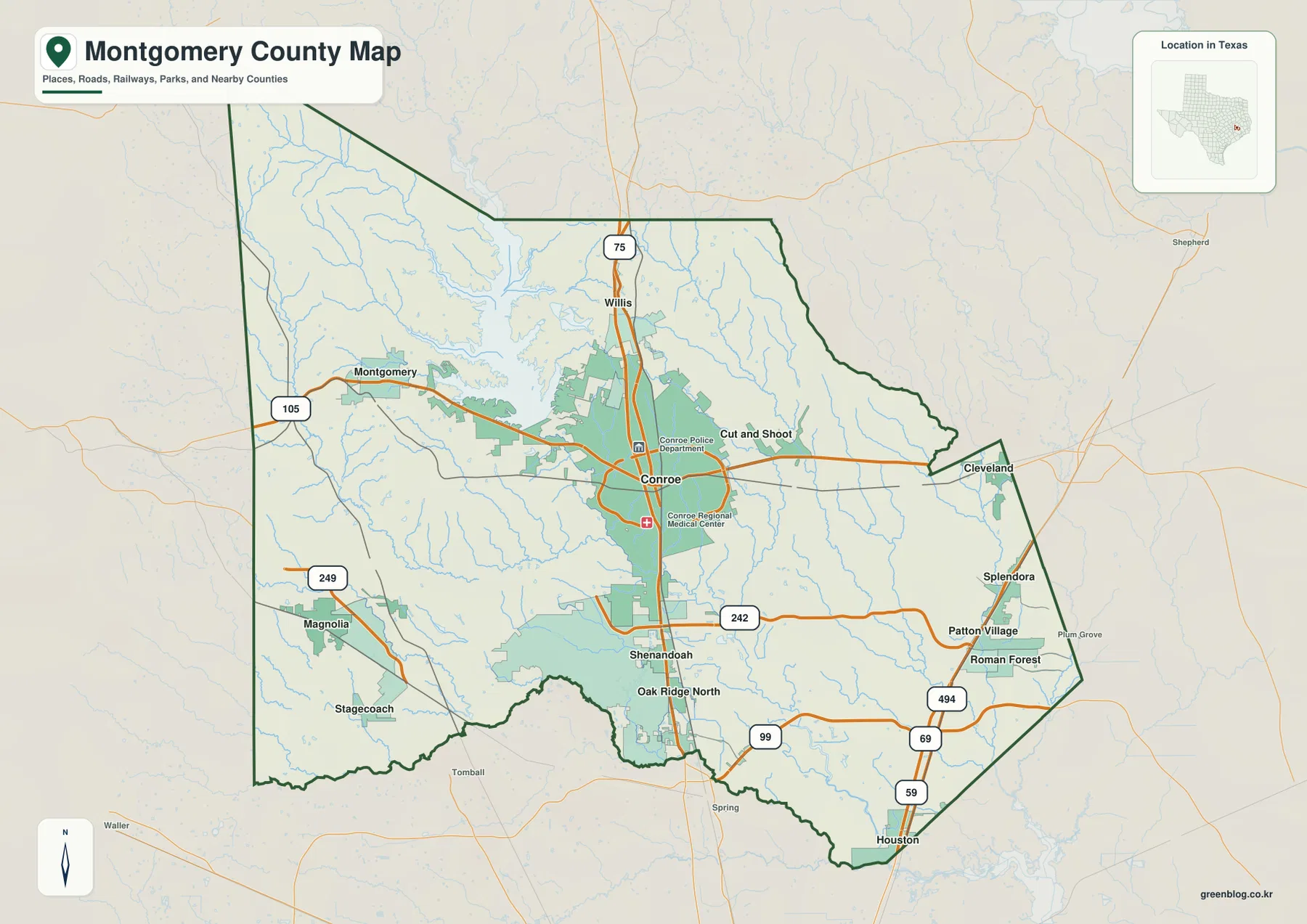
Conroe is the strongest developed place on the general county map. Road 75 runs north toward Willis, while Route 105 extends west toward Montgomery and the Lake Conroe side. An eastward route leads toward Cut and Shoot, giving Conroe three clear directional references before the denser southern network begins.
South of Conroe, Route 242 crosses near Shenandoah and continues east. Route 99 is farther south, with 494, 69, and 59 providing additional references toward the southeastern and eastern edges. The road spacing and developed shading become more continuous in this direction than around the lake-side northwest.
Magnolia is well southwest of Conroe near Route 249, with Stagecoach farther south. Montgomery lies west of Conroe, while Willis is north. Reading these places as separate directions rather than one urban line helps explain why the county contains several settlement clusters divided by lake shore, creek valleys, and wooded hills.
The ranked city map shows a strong Conroe lead and a north-south spread of smaller cities
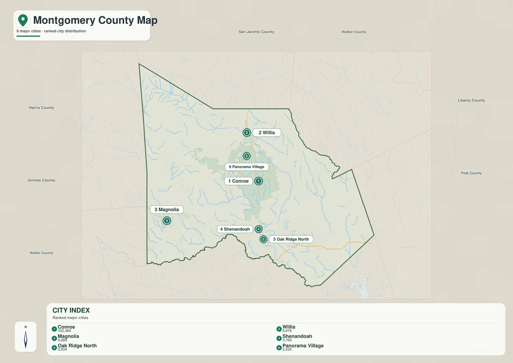
The city map ranks six major cities. Conroe is number 1, followed by Willis, Magnolia, Shenandoah, Oak Ridge North, and Panorama Village. The lower index prints the values 102,360 for Conroe, 6,878 for Willis, 4,068 for Magnolia, 3,705 for Shenandoah, 3,034 for Oak Ridge North, and 2,525 for Panorama Village.
No year is shown for those figures, so this article treats them only as values printed on the map rather than confirmed current population counts. Their positions are more useful for this page. Willis lies north of Conroe, Magnolia is southwest, Shenandoah and Oak Ridge North are close together south of Conroe, and Panorama Village sits in the central-northern corridor between Conroe and Willis.
With most minor roads and labels removed, the city map makes the concentration around Conroe and the southern corridor easy to see. The northwest around Lake Conroe has much less ranked-city shading, reinforcing the difference between the lake-and-hill landscape there and the more urbanized southern side.
Lake Conroe dominates the northwest water landscape
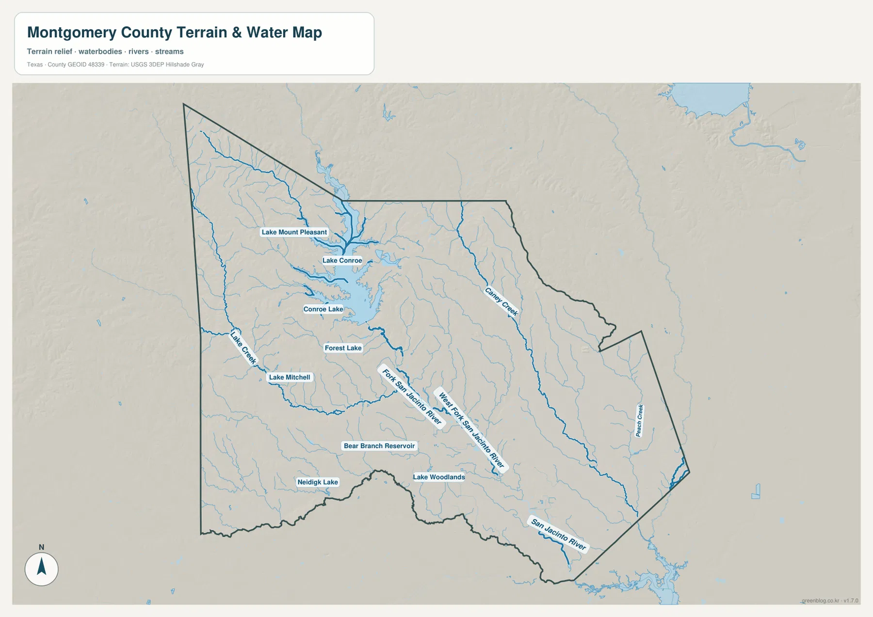
Lake Conroe is the largest and most obvious named water body on the terrain-and-water map. Its irregular shoreline occupies much of the northwestern and north-central interior, with numerous short tributaries entering from surrounding hills. Lake Mount Pleasant is labeled on the western side, and smaller water bodies including Conroe Lake, Forest Lake, and Lake Mitchell appear farther south and southwest.
Lake Creek enters from the western side below the main lake area. Caney Creek follows a long valley through the northeastern interior, while Peach Creek is labeled farther east. These streams do not all drain through one visible corridor on the map; instead they divide the county into several separate valleys around the lake, central hills, and eastern lowlands.
West Fork San Jacinto River carries the central drainage into the southern lowlands
South of the Lake Conroe area, the West Fork San Jacinto River becomes the most important named river reference. It runs through the central-southern interior and continues toward the lower county, where San Jacinto River is labeled near the southern boundary. This river corridor corresponds closely with some of the lowest green terrain on the elevation map.
Bear Branch Reservoir and Neidigk Lake are labeled in the southwest, while Lake Woodlands appears closer to the southern urban area. These smaller water bodies provide useful local references near Shenandoah and Oak Ridge North. Their setting is different from Lake Conroe: instead of a large lake surrounded by broad uplands, the southern map is dominated by lower river and creek corridors close to a denser road network.
The terrain-and-water map is intended for geographic reference. It can help locate Lake Conroe, Lake Creek, Caney Creek, Peach Creek, the West Fork San Jacinto River, San Jacinto River, and the smaller named lakes and reservoirs, but it is not a flood-hazard map, parcel map, legal water-boundary product, or navigation chart.
Northwestern hills descend toward broad southern and southeastern lowlands
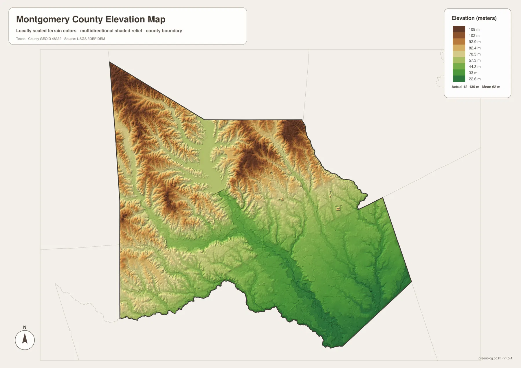
The elevation map reports an actual range of about 12 to 130 meters and a mean elevation of about 62 meters. The highest brown terrain is concentrated across the northwest and west, with additional ridges around the north-central Lake Conroe area. In contrast, the south and southeast are broadly green and lower, especially along the San Jacinto River and major creek corridors.
The northwest is not a single smooth upland. Tributaries cut narrow green valleys through brown and tan ridges, and the Lake Conroe shoreline reaches into many of those lower channels. This creates a strongly textured hill-and-valley pattern around the lake even though the county’s absolute elevations remain modest.
Moving south from Conroe, the terrain becomes progressively lower and less rugged. The Shenandoah–Oak Ridge North side occupies broad green terrain, while Peach Creek and the southeastern drainage network also follow low corridors. The difference between the displayed minimum and maximum elevation is about 118 meters, enough to make the northwest-versus-southeast contrast obvious on the shaded map.
The elevation layer is best used for relative terrain comparison rather than survey-grade or engineering-grade measurement. Its value here is to connect Conroe, Willis, Magnolia, Lake Conroe, and the San Jacinto River system with the county’s clear shift from higher northwest hills to lower southern terrain.
Comparing both sides of Conroe reveals the county’s strongest geographic contrast
Move northwest from Conroe toward Montgomery and Lake Conroe and the landscape becomes less urban and more strongly shaped by shoreline, tributaries, and ridges. The water map fills this area with an irregular lake edge and branching streams, while the elevation layer alternates between brown uplands and narrow green valleys.
Move south instead toward Shenandoah and Oak Ridge North and the pattern changes. Roads and developed areas become more continuous, Lake Woodlands appears near the urban corridor, and the West Fork San Jacinto River enters a much lower landscape. Farther east, Peach Creek follows another broad low valley. These two directions from Conroe explain more about the county than a simple city-and-lake title alone.
A practical reading order is to locate Conroe and the surrounding cities first, then match Lake Conroe and the San Jacinto River system to the same positions, and finally compare the elevation layer. Smaller creek names and road numbers are often easier to inspect in the downloadable high-resolution JPG files than in the browser previews.
Frequently Asked Questions
Which cities are ranked on the Montgomery County city map?
The map ranks Conroe first, followed by Willis, Magnolia, Shenandoah, Oak Ridge North, and Panorama Village. It also prints index values for each city, but no year is shown, so this article does not present those figures as confirmed current population counts.
Which water features are the best starting points?
Lake Conroe is the clearest northwestern reference. From there, Lake Creek, Caney Creek, and Peach Creek help divide the interior, while the West Fork San Jacinto River and San Jacinto River provide the main southern river references. Lake Woodlands and Bear Branch Reservoir are useful smaller landmarks.
What elevation range is shown for Montgomery County?
The supplied elevation map reports an actual range of about 12 to 130 meters and a mean elevation of about 62 meters. The northwest and west are generally higher, while the southern and southeastern river and creek valleys occupy lower terrain.
Sources and Reference Data
- U.S. Census Bureau TIGER/Line Shapefiles — official county-boundary and road geometry for geographic reference.
- USGS National Hydrography — official resources for rivers, creeks, lakes, reservoirs, and other water features.
- USGS 3D Elevation Program — official elevation resources used for terrain information.
- USGS The National Map Viewer — an official viewer for comparing geographic layers.
Map File Information
Download four high-resolution A3 JPG maps of Montgomery County, Texas, in one ZIP file.
- Included Files: county map, ranked city map, terrain and water map, elevation map
- File Type: JPG
Related Maps
- San Jacinto County Texas map
- Walker County Texas map
- Waller County Texas map
- Washington County Texas map
- Polk County Texas map
Green Map creates custom-edited map images using open geographic data sources such as geoBoundaries, Natural Earth, OpenStreetMap, and government open data.
These maps are edited visual materials, not raw data files, and are provided for education, documents, presentations, and graphic reference.