Irwin County lies in south-central Georgia with Ocilla as its county seat and principal city reference. The county is largely rural on the supplied maps, but its physical geography is far from empty: the Alapaha River occupies a western valley, the Willacoochee River and Satilla Creek organize much of the east, and smaller tributaries divide the interior into repeated low corridors. The four map views on this page separate those features so they remain readable. The general map shows Ocilla, numbered roads, streams, and the boundary; the city view isolates Ocilla; the water map labels rivers, creeks, lakes, and ponds; and the elevation map reports an actual range of about 67 to 122 meters with a mean of 96 meters. The downloadable ZIP contains four high-resolution A3 JPG originals for readers who need larger map files than the web previews.
Ocilla is the easiest reference point because it sits close to the middle of the county and is crossed by several important roads. Route 32 runs east-west through the city, while Routes 129 and 11 continue south. Other numbered roads spread across the west, north, and southern edge. Beyond Ocilla, settlement labels become sparse but stream lines become more prominent. That contrast is important for reading Irwin County: roads and one central city provide orientation, while rivers, creeks, and gentle uplands explain much of the space between them.
Table of Contents
Ocilla, Numbered Roads, and an Irregular County Outline
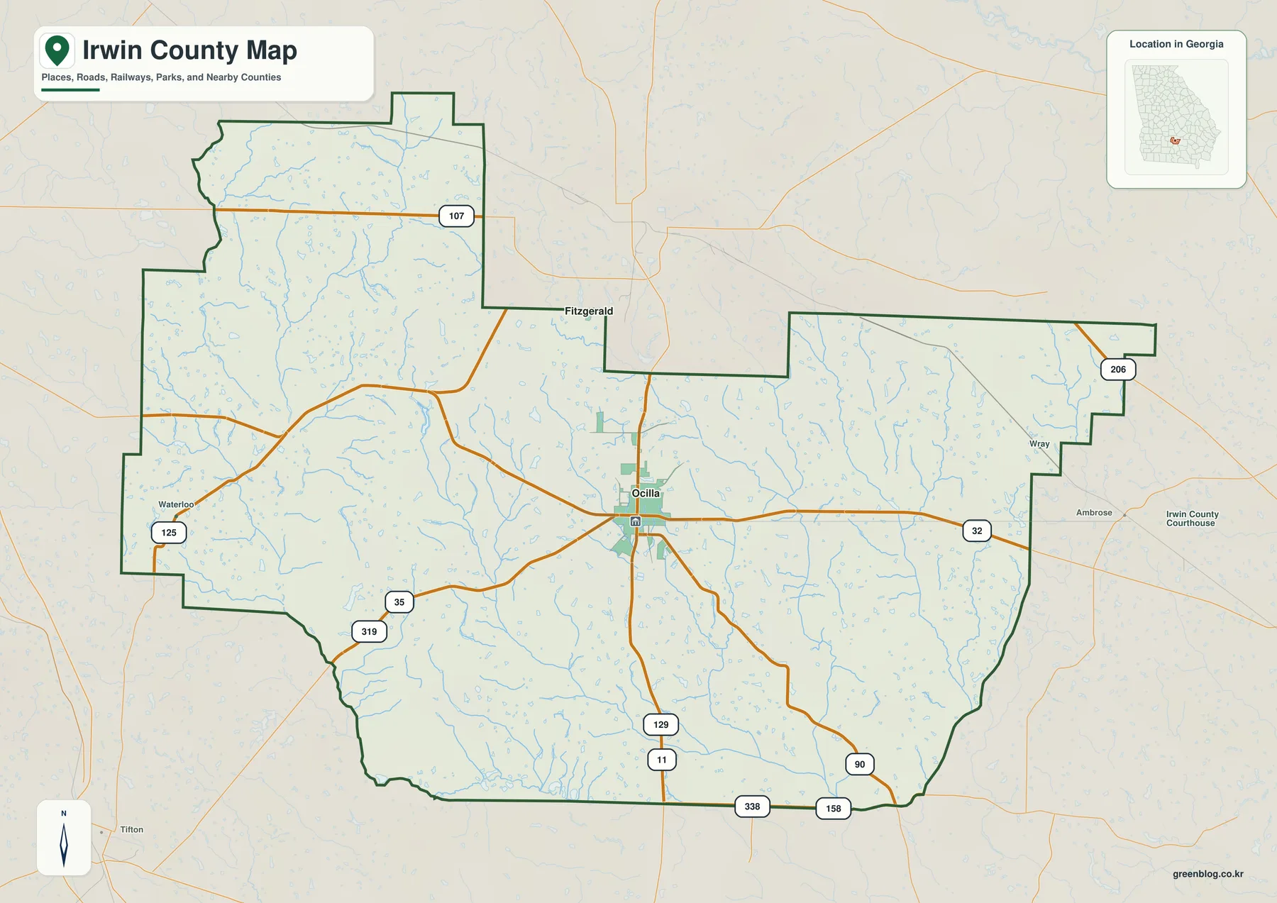
Ocilla is the strongest place label inside the boundary and serves as the natural starting point for the general map. Route 32 crosses the city from west to east. Routes 129 and 11 continue south, giving the central county a clear north-south reference. Routes 35 and 319 cross the southwestern interior, Route 125 appears on the western side, and Route 107 provides a northern reference. Along the lower edge, Routes 338 and 158 are labeled, while Route 90 appears toward the southeast. At this scale, these roads are most useful for understanding direction rather than for turn-by-turn navigation.
The county boundary has a distinctive shape. A northern extension rises above the western half, the north-central boundary steps inward, and a broad eastern block projects toward the Coffee County side. Numerous blue tributaries fill the open spaces between roads, so the rural interior is not a featureless plain. Small valleys divide the county repeatedly, especially where tributaries approach the larger western and eastern waterways. This detail becomes much more obvious on the dedicated terrain-and-water map.
Several place names outside Irwin County help with regional orientation. Fitzgerald appears just north of the boundary, Waterloo lies to the west, and Wray and Ambrose are shown beyond the eastern side. They should not be mistaken for places highlighted inside the county. The general map uses them as surrounding references, making it easier to understand where Ocilla sits within south-central Georgia and how the numbered roads continue beyond the county line.
Why Ocilla Is the Only Ranked City on This View
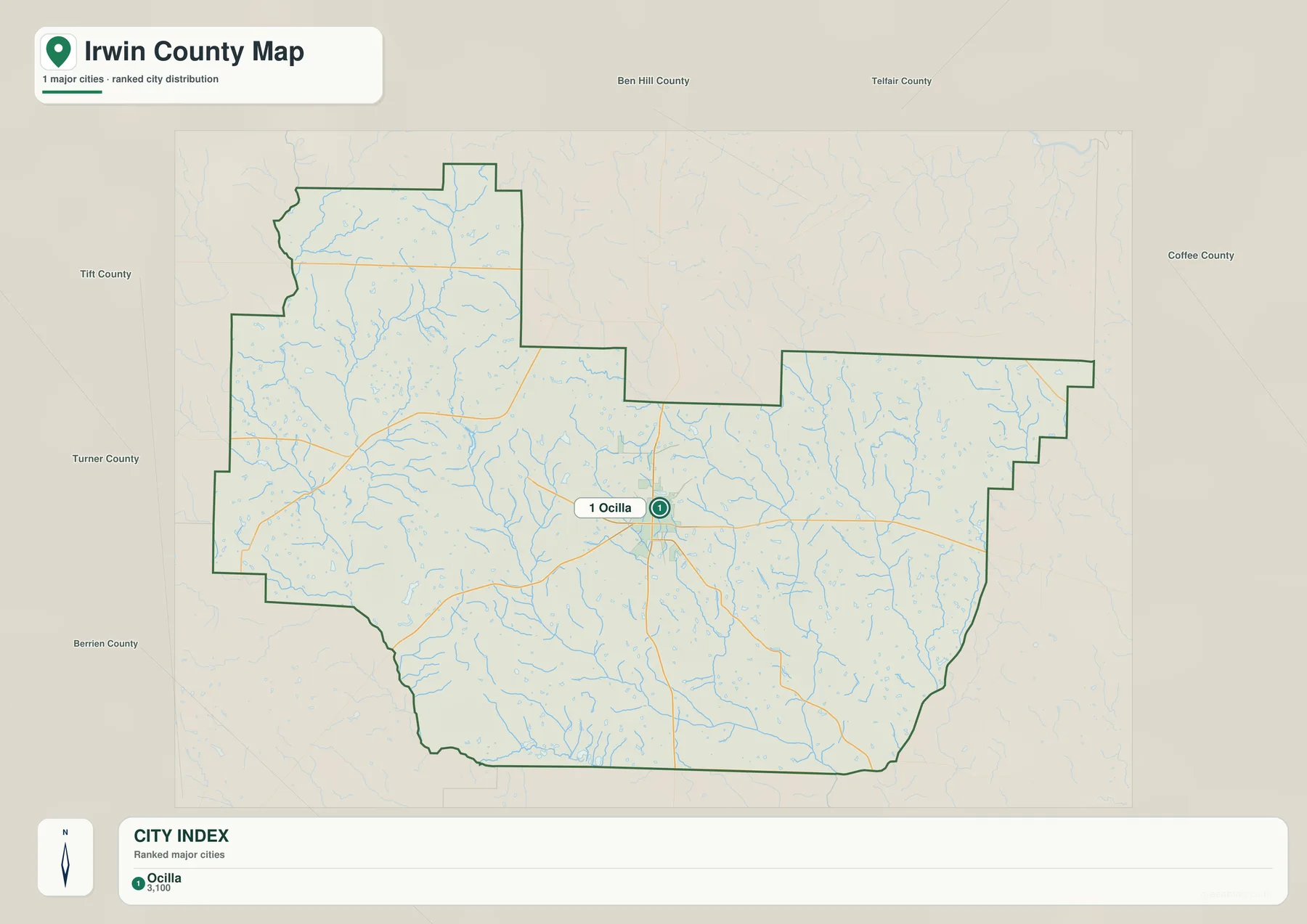
The city map is intentionally sparse. Its CITY INDEX contains one ranked place: Ocilla at 3,100. That number is reproduced from the supplied map only to explain the graphic and should not be treated as a newly verified population estimate for this article. Anyone who needs current demographic figures can use the U.S. Census Bureau source listed below. The practical value of this view is its simplicity: it shows where Ocilla sits within the unusual county outline without competing road, facility, or water labels.
The older page text mentioned both Ocilla and Irwinville, describing Irwinville as a historic rural reference point. The current four-map package, however, does not label Irwinville on the ranked city map. This rewrite therefore avoids implying that it is one of the visible city labels. Ocilla is the actual city reference shown on the new map, while Irwinville belongs to the older contextual material rather than the present city graphic.
Ben Hill, Telfair, Coffee, Tift, Turner, and Berrien counties appear around the frame. Their placement helps define Irwin County’s position in the region: Ben Hill is to the north, Coffee is east, and Tift, Turner, and Berrien provide western and southern context. These labels are intended for orientation rather than survey work. Because the interior city layer is so simple, the surrounding county names become especially helpful for understanding the county’s broader setting.
Alapaha River, Willacoochee River, and the Interior Creek Valleys
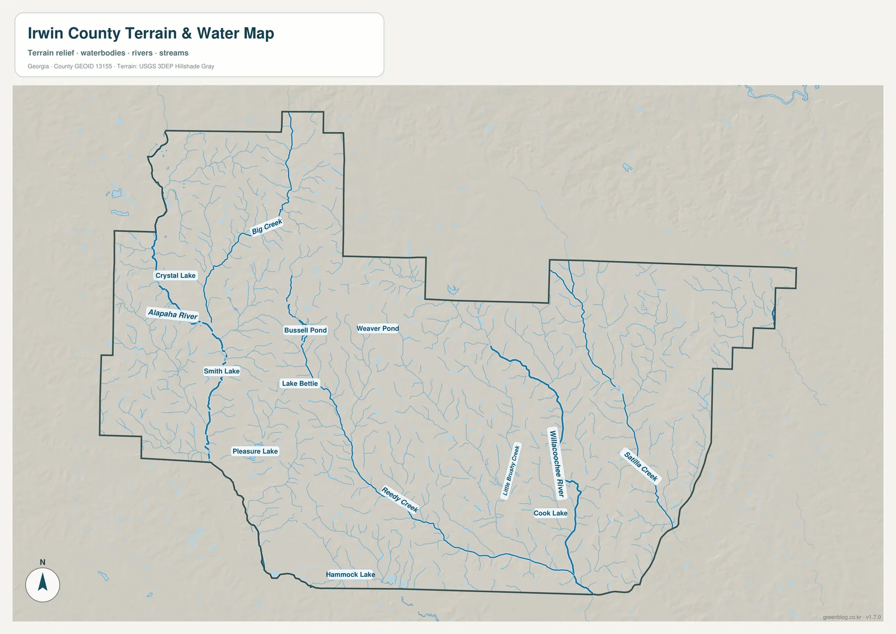
The Alapaha River is the strongest western water reference. It runs through a low corridor on the western side of the county and receives smaller tributaries from the surrounding rural interior. Big Creek is labeled farther north and joins the broader western drainage pattern. Crystal Lake sits close to the Alapaha corridor, with Smith Lake and Pleasure Lake farther south. These waters are modest compared with a large reservoir, but together they make the western side of Irwin County easy to recognize on the water map.
The eastern half is organized by a different group of channels. The Willacoochee River forms a long north-south reference through the east-central interior, with Little Brushy Creek nearby. Satilla Creek occupies another long valley farther east and continues toward the southeastern boundary. Cook Lake is labeled close to the Willacoochee corridor. Placing these features beside the Alapaha River shows that Irwin County is divided among multiple drainage valleys rather than being centered on one single river.
Several smaller waters provide useful inland landmarks. Bussell Pond and Weaver Pond appear in the north-central part of the county, while Lake Bettie is farther south near a stronger creek line. Reedy Creek runs through the south-central interior and continues eastward through low ground. Hammock Lake appears near the southern edge. These names are valuable in a rural county where many areas have few settlement labels; a creek, pond, or lake can provide a clearer position reference than a distant town name.
This map is designed to show water features at county scale. It does not determine flood status for a parcel, legal property limits, water depth, or public access to a pond or stream. Those decisions require current local or agency records. For ordinary map reading, the useful relationships are the Alapaha River in the west, the Willacoochee River in the east-central county, Satilla Creek closer to the eastern edge, and the smaller creeks that connect the rural interior with those larger valleys.
Elevation from About 67 to 122 Meters
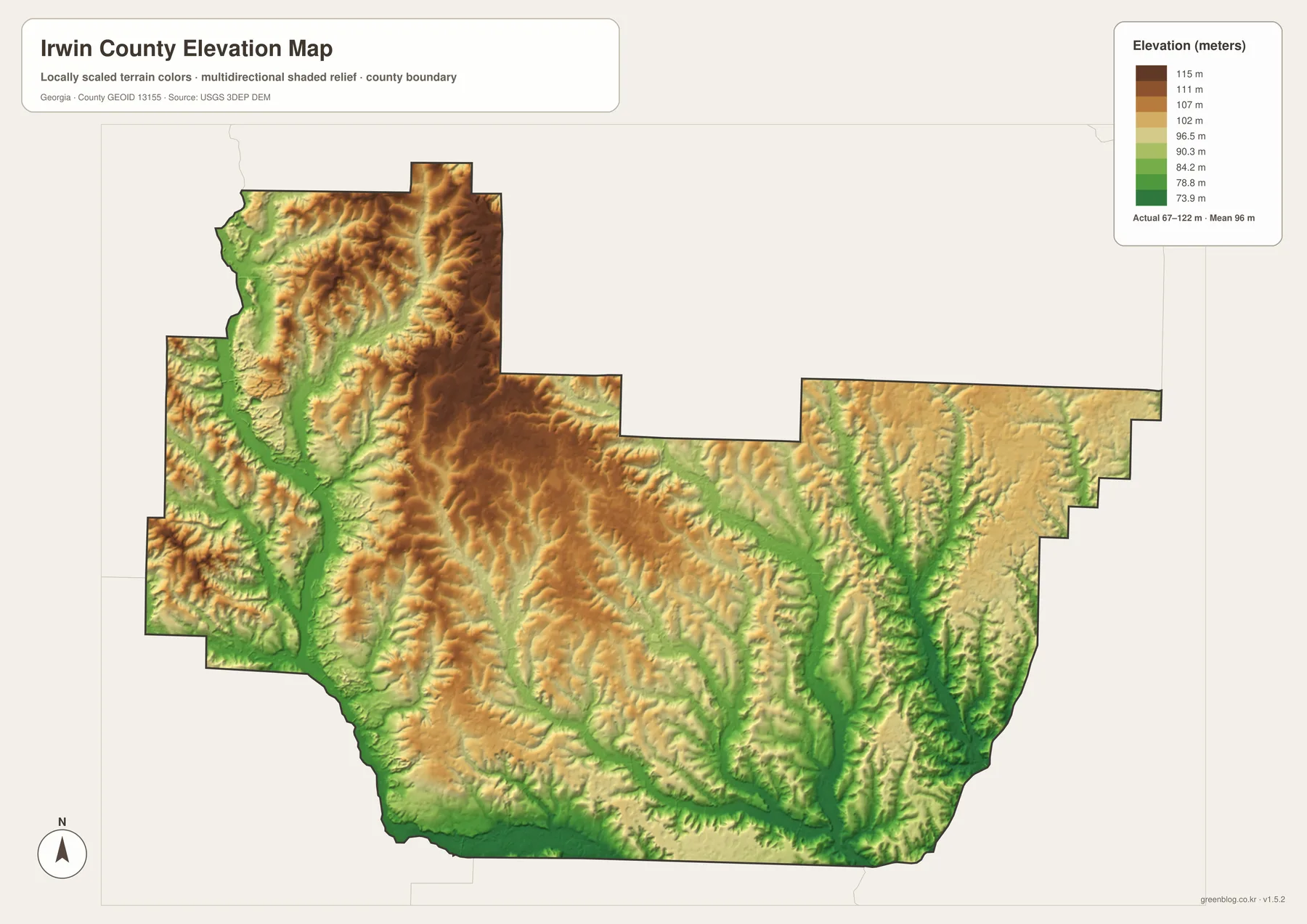
The supplied elevation map reports an actual range of approximately 67 to 122 meters, with a mean of 96 meters. That is a modest overall difference, but the shaded relief reveals more structure than a flat-road map. Brown and tan higher ground is concentrated through much of the central and northern interior, while long green lowlands follow the western river corridor, the eastern waterways, and several southern tributaries. The county is therefore gently rolling rather than uniformly level.
The Alapaha River valley is easy to match with the relief. A green low corridor runs through the western side and widens around some tributary junctions. Big Creek also occupies lower terrain as it approaches the same western system. Moving east from the river, short ridges become more visible before the terrain drops again around the central creek network. This alternating pattern of small uplands and low drainage channels explains why the relief appears textured even though the total elevation range is only about 55 meters.
The Willacoochee River and Satilla Creek form another set of low corridors in the eastern half. Green valleys extend southward along both channels, and smaller tributaries cut into the surrounding tan terrain. Reedy Creek also occupies lower ground through the south-central county. The highest areas are not dramatic mountain ridges; they are broad, gently elevated interfluves between the larger waterways. That distinction matters when describing Irwin County accurately.
The elevation layer is appropriate for broad county comparison, not for determining the exact height of a building site, road project, drainage design, or property corner. More detailed elevation data and field work may be necessary for site-level decisions. For a geography class, county profile, or presentation, the 67–122 meter range clearly shows how slightly higher central ground separates the Alapaha, Willacoochee, Satilla, and smaller creek valleys.
Ocilla’s Rural Setting Between Two Major Drainage Valleys
The source material in the package states that Irwin County was established in 1818 and describes agriculture, forestry, peanut production, and Civil War-era history as parts of its local background. The maps here do not measure crop output, forest acreage, or historical sites. Instead, they provide the geographic framework beneath that context: Ocilla near the center, a sparse settlement pattern beyond the city, numbered roads crossing rural land, and the Alapaha and Willacoochee river systems separated by gently higher interior ground.
The general reference map is the best place to start when Ocilla, numbered roads, the county outline, and surrounding places all matter. The city map is cleaner when the goal is simply to locate Ocilla. The water view is the strongest reference for the Alapaha River, Willacoochee River, Big Creek, Reedy Creek, Satilla Creek, and named lakes, while the elevation layer explains how those waterways occupy lower corridors between modest uplands.
Ocilla ties those themes together. Route 32 crosses the city from west to east, Routes 129 and 11 continue south, and numerous smaller streams spread into the surrounding countryside. Traveling conceptually west from Ocilla brings the Alapaha River valley into view; moving east leads toward the Willacoochee River and Satilla Creek side. Between them lies gently higher terrain cut by many smaller tributaries. Comparing the four maps makes that rural structure easier to understand than a city list alone.
Frequently Asked Questions
Why is Ocilla the only ranked city on the city map?
The supplied city view ranks only Ocilla, with a displayed CITY INDEX value of 3,100. The older article mentioned Irwinville as historical context, but it is not shown as a ranked city on the current map.
Which rivers and creeks are easiest to identify?
The Alapaha River is the main western reference, while the Willacoochee River and Satilla Creek are prominent in the east. Big Creek, Reedy Creek, and Little Brushy Creek provide additional named valleys, and Crystal Lake, Lake Bettie, and Cook Lake are useful small-water landmarks.
What elevation range is shown for Irwin County?
The map reports an actual range of about 67 to 122 meters and a mean of 96 meters. Central and northern uplands are generally a little higher, while the Alapaha, Willacoochee, Satilla, and southern creek valleys occupy lower terrain.
What is included in the A3 map ZIP?
The archive contains four large JPG originals covering the general county reference, Ocilla city location, waterways, and elevation. Keeping the subjects in separate files makes roads, the city label, creek names, and relief easier to read when printed or placed in a document.
Map File Information
Irwin County A3 Map Files
- Included Files: Map files described on this page
- File Type: ZIP archive
- Intended Use: Printing, education, presentations, and map-based projects
Related Maps
Irwin County Data and Map References
- U.S. Census Bureau QuickFacts: Irwin County – current official county statistics
- Irwin County official website – county government and local information
- New Georgia Encyclopedia: Irwin County – county history and the 1818 establishment date
- Census TIGER/Line boundary resources – county and neighboring-boundary reference geometry
- USGS hydrography resources – reference data for the Alapaha and Willacoochee rivers, creeks, lakes, and ponds
- USGS 3DEP elevation resources – source elevation data for comparing the 67–122 meter terrain range
Green Map creates custom-edited map images using open geographic data sources such as geoBoundaries, Natural Earth, OpenStreetMap, and government open data. These maps are edited visual materials, not raw data files, and are provided for education, documents, presentations, and graphic reference.