A Portugal Map must balance a long north–south mainland with two Atlantic archipelagos that lie far beyond the Iberian Peninsula. If every territory were placed at one true scale, the mainland district labels would become too small for a practical landscape page. The supplied set solves that problem by giving continental Portugal the main panel and placing the Azores and Madeira in separate framed insets.
Three versions use this arrangement for different tasks. The color map labels the 18 mainland districts, marks Lisbon, and distinguishes sea and land; the black-and-white map retains those labels with reduced color coverage; and the outline removes the names and capital symbol for activities or custom graphics. Spain remains visible beyond the eastern border, while the two island boxes keep the whole national territory in view.
The color and monochrome previews measure 1200×848 pixels, and the outline measures 1200×849 pixels. They are simplified raster references rather than navigation charts, survey products, or authoritative boundary datasets. Their value lies in comparing mainland district shapes, the capital’s position, the single land border with Spain, and the inclusion of both autonomous Atlantic regions without adding roads, terrain, rivers, or municipal detail.
목차
Why This Portugal Map Was Compiled
The mainland is narrow enough that labels can compete with boundaries, especially in the north and along the coast. Viana do Castelo, Braga, Porto, Aveiro, and neighboring interior districts occupy limited horizontal space. Farther south, larger areas such as Beja and Évora provide more room. A consistent layout makes those contrasts legible without reducing the Azores and Madeira to tiny marks or omitting them entirely.
Inset boxes are a page-design device, not a statement about distance. The Azores appear as a scattered chain in the upper box, and Madeira appears with nearby island shapes in the lower box. Their placement beside the mainland allows each archipelago to remain recognizable, but readers should not measure the ocean gap, compare scale, or infer travel time from this Portugal Map.
Understanding Portugal’s Regional Layout
Mainland Portugal occupies the western and southwestern edge of the Iberian Peninsula. The Atlantic borders its west and south, while Spain forms the entire land boundary to the north and east. On the labeled Portugal Map, the coastal sequence can be followed from Viana do Castelo and Porto through Aveiro, Coimbra, Leiria, Lisboa, Setúbal, Beja, and Faro.
The interior side is organized around districts including Vila Real, Bragança, Viseu, Guarda, Castelo Branco, Santarém, Portalegre, and Évora. Braga lies in the northwest, and Lisbon’s district is highlighted by a red star near the Tagus estuary area. The star identifies the capital location, but the graphic does not provide a complete city network or distinguish urban boundaries.
These mainland divisions are districts, while the Azores and Madeira are autonomous regions. The island boxes show geographic outlines and regional inclusion, not district subdivisions within the archipelagos. A worksheet should therefore avoid asking learners to read every internal administrative level from the same sheet. The files are most reliable when the task is limited to mainland district orientation and recognition of the two Atlantic regions.
No scale bar, coordinates, road classes, relief shading, river network, or municipality boundaries appear. The map can help a reader see why Porto is in the north, Faro in the south, and Spain to the east, but it cannot determine driving distance or route choice. Use current transport and geographic sources for navigation, precise measurement, or boundary-sensitive work.
How the Map Set Is Structured
The mainland is placed on the right side of each landscape canvas. That decision leaves room on the left for the ocean label, the Azores box, and the Madeira box while keeping the narrow country large enough to read. Spain’s pale or gray field provides contrast beyond the border. This shared framework helps each Portugal Map version function as part of one coordinated set.
The source artwork contains embedded wording that should be interpreted carefully. “acores” and “braganca” omit the Portuguese diacritics used in Açores and Bragança, while some names use inconsistent capitalization. “OCEANO ATLANTICO” is Portuguese wording without the expected accents rather than an English water label. The protected images remain unchanged, so formal publications should provide corrected names in surrounding text or a separate key.
Map Variations Included in This Set
Each Portugal Map answers a distinct practical question. The color version asks readers to orient themselves quickly, the monochrome version keeps reference labels while making annotations more prominent, and the outline invites users to supply names or categories. Selecting the version according to the task keeps the page clear and prevents decorative features from competing with new information.
1️⃣ Color-Based Regional Map
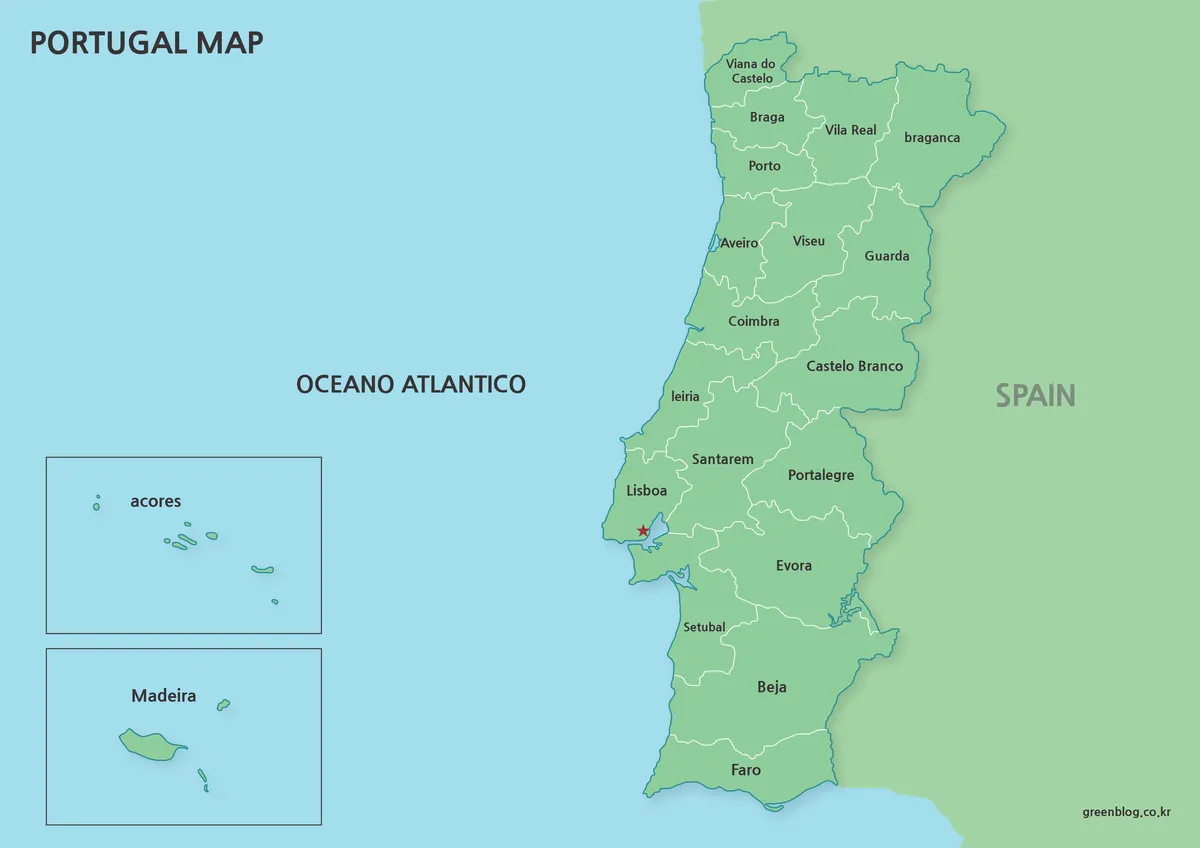
The color Portugal Map uses green land, pale blue ocean, white mainland district lines, and a red star for Lisbon. Spain appears in a related green field beyond the darker national border. The simple palette creates a hierarchy of country shape, district pattern, capital, and island insets. Because every Portuguese district shares one fill, green does not represent population, elevation, land cover, or another measured value.
This is the strongest introductory version for a slide, country profile, or labeled reference sheet. New symbols should differ from the red capital marker, and route lines should remain distinct from district borders. If data are added, include a dated legend with units and source information rather than allowing viewers to interpret the decorative base color as a category.
2️⃣ Black-and-White Boundary Map
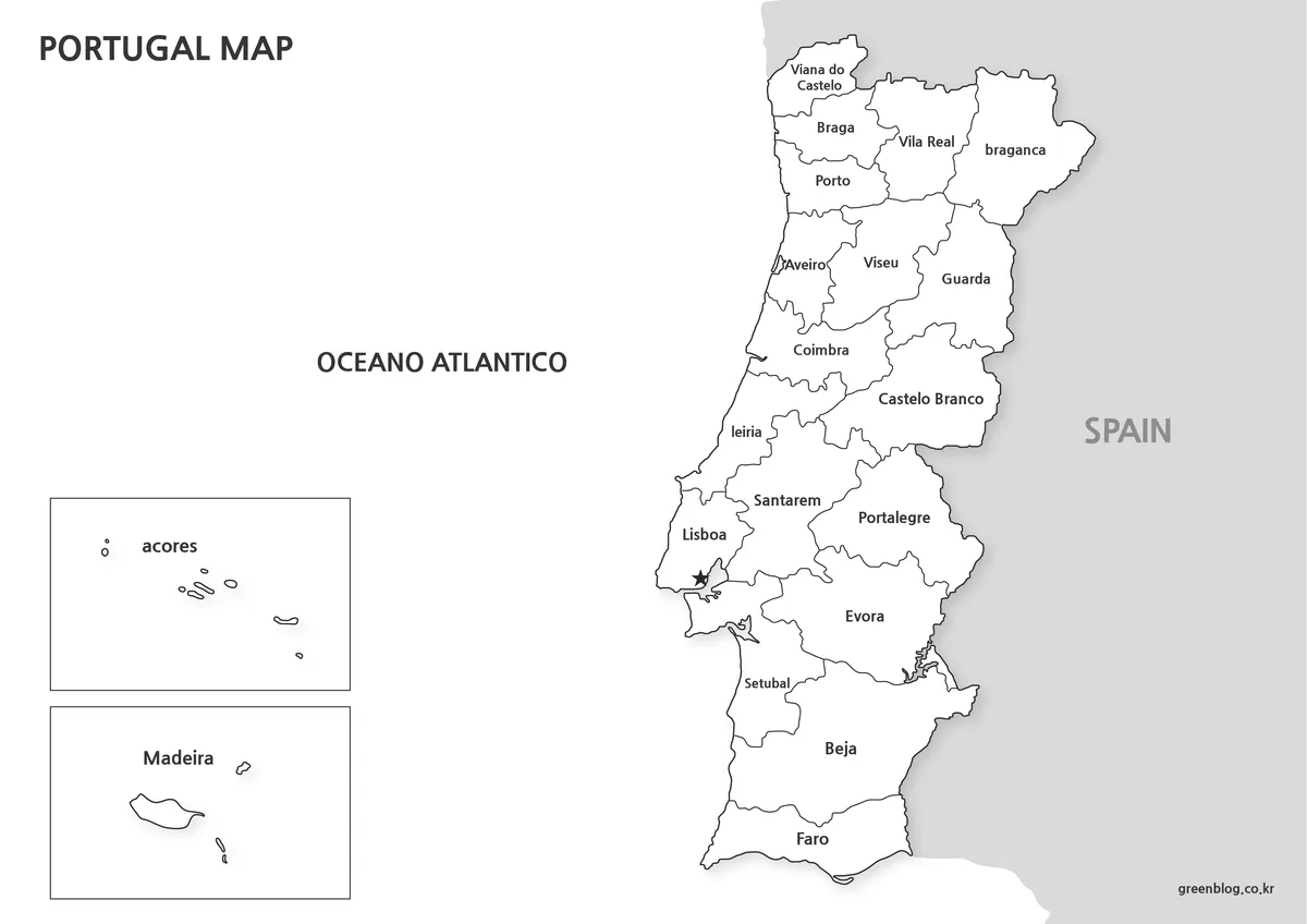
The black-and-white Portugal Map retains the 18 district names, Lisbon star, Spain label, Atlantic wording, and both island boxes. White land and ocean reduce ink coverage, while dark boundaries remain visible against Spain’s light gray background. Handwritten arrows, highlighter marks, numbered callouts, and colored pencils gain more contrast than they would on the green and blue reference.
This version works as a labeled worksheet, discussion handout, report figure, or answer key. It is not a blank quiz because the district names remain. Print one proof at the intended size before producing multiple copies: compact northern labels and thin internal lines can become difficult to distinguish after aggressive reduction or low-quality photocopying.
3️⃣ Outline-Only Map for Graphic Work
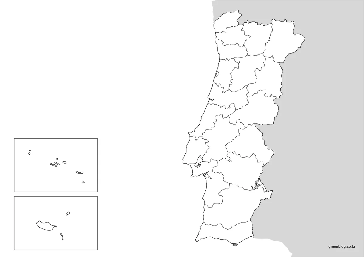
The outline Portugal Map removes the title, district names, Lisbon marker, Spain label, and ocean text. It preserves the mainland coastline and district boundaries, Spain’s gray surrounding field, and the two framed island groups. This makes the file geographically blank enough for activities while retaining the administrative structure that differentiates it from a simple national silhouette.
Students can label the mainland districts, identify the capital, distinguish coastal and inland areas, or add the names of the two autonomous regions. Designers can assign colors to selected districts or build a thematic legend. Use numbered keys where northern shapes are too small for long text, and keep the inset boxes visible so the final graphic does not imply that Portugal consists only of the mainland.
The file is a raster base rather than an editable geographic database. Enlarging it substantially may soften thin lines, and filling regions requires care around narrow boundaries. It should not be used for legal boundary interpretation, cadastral work, exact area calculation, or GIS analysis. A current authoritative dataset is necessary for those tasks.
Practical Contexts for Using These Maps
For a classroom sequence, display the color Portugal Map while explaining the mainland, Spain, Lisbon, the Azores, and Madeira. Distribute the outline for recall, then use the monochrome sheet as a labeled reference. The coordinated geometry lets learners compare their work without adjusting to a different coastline or inset arrangement.
For presentations, choose color when immediate recognition matters and monochrome when other charts already carry the palette. Crop cautiously: removing the left side also removes the island boxes and changes the national scope. Place legends or callouts in open space without covering either inset, and state when the boxes are not drawn at the mainland’s scale.
- District study: follow the mainland divisions from the northern border to Algarve.
- Island context: keep the Azores and Madeira visible as separate autonomous regions.
- Print work: use monochrome for notes and outline for independent labeling.
- Design: add a legend, date, units, and source to a duplicate of the outline.
Additional Notes for Reading the Portugal Map
A map that combines mainland districts and island insets prioritizes legibility over a single geographic scale. It can show that the Azores and Madeira belong to Portugal and preserve their general island shapes, but it cannot compare their true distance, area, or orientation with the mainland. Captions should explain that design choice whenever spatial measurement could be misunderstood.
Formal use also requires a naming check. Embedded labels without diacritics should not be copied automatically into an official list, and the graphics do not display internal island municipalities or all urban places. Compare new annotations with a current official source, record the date, and describe the map as a general district reference rather than a complete administrative atlas.
Frequently Asked Questions
The preserved FAQ addresses editing, printing, and graphic use. In every case, remember that a Portugal Map with island insets is intended for visual reference: preserve the original files, test small labels at output size, and use an authoritative source for measurements or boundary-sensitive decisions.
Can I edit the map files for my own work?
Yes. Adjusting size, adding text, or making small changes for personal or internal use is fine. Please avoid redistributing modified files.
Will the maps remain clear when printed?
They were prepared in a print-friendly color mode, and boundary lines stay sharp even when printed in black and white.
Are these maps suitable for graphic editing?
The outline version in particular works well as a starting image in common editing software, making it easier to build custom visuals.
Download Information
The protected ZIP groups the three coordinated map treatments shown above. Download the archive, keep an untouched master copy, and edit duplicates for labels, colors, notes, or classroom instructions. Compare the previews first so the selected file already matches the project’s need for reference detail or customization.
Map File Information
This archive combines two labeled district references with an unlabeled boundary base.
- Included Versions: Color labeled, black-and-white labeled, and blank outline
- Intended Use: Study, printing, annotation, presentations, and design
Related Maps
Additional Resources
- VisitPortugal: About Portugal — Read an official overview of mainland Portugal, the Azores, and Madeira.
Green Map creates custom-edited map images using open geographic data sources such as geoBoundaries, Natural Earth, OpenStreetMap, and government open data. These maps are edited visual materials, not raw data files, and are provided for education, documents, presentations, and graphic reference.