Keya Paha County occupies a wide strip of north-central Nebraska directly below the South Dakota line. Springview is the main administrative and road reference, with U.S. 183 running north–south and Nebraska Highway 12 crossing the same area from west to east. The Niobrara River forms the winding southern edge of the county, while the Keya Paha River drains the northeastern side near Burton. This page compares the general county map, the sparse city distribution, the river and creek network, and an elevation range of about 536 to 807 meters. Four original high-resolution JPG maps are also available together in a ZIP file for printing or close viewing. High-resolution map files are available for download in the section below.
The physical landscape is more useful than town density for understanding this county. Higher ground covers much of the west and northwest, then the surface falls toward lower eastern valleys and the two major rivers. Along the southern boundary, dozens of short tributaries descend sharply toward the Niobrara. Farther east, Burton Creek, Spring Creek, Holt Creek, and other channels divide the uplands before reaching larger drainage routes. Once Springview, the Niobrara River, and the Keya Paha River are located, the rest of the county becomes much easier to organize.
Table of Contents
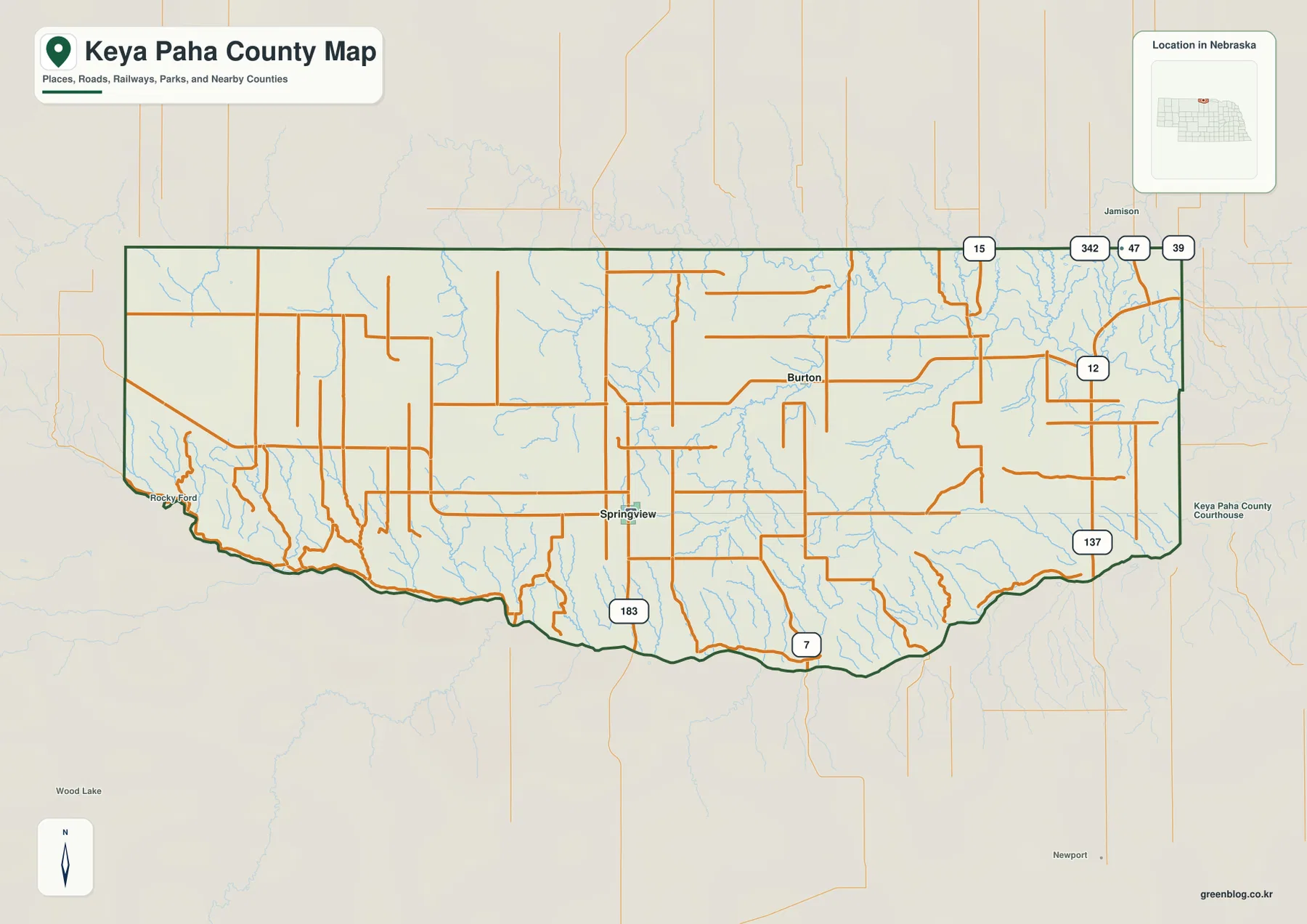
Springview makes U.S. 183 and Highway 12 the simplest road framework
Springview is the best starting point on the general county map. U.S. 183 runs through the community and continues south toward the Niobrara River, while Highway 12 crosses the area from west to east. Nebraska Department of Transportation reference material confirms that the two routes share a short section around Springview. In a county with few large settlements, that highway junction provides a much stronger orientation point than a dense street network would.
North and west of Springview, many rural roads run in long straight segments across broad uplands. South of town, the network becomes less regular as roads approach the deeply cut tributaries above the Niobrara River. Burton lies to the east and northeast, with Highway 12 and local roads connecting the surrounding ranch country. The map also labels Highway 137 in the southeast, Highway 7 along the southern interior, and Highway 15 near the northeastern side, giving several additional route references around the county.
The outer frame is just as useful. South Dakota is directly north, while Boyd, Holt, Rock, Brown, and Cherry counties appear around the Nebraska sides of the map. The southern boundary is notably irregular because it follows the Niobrara River rather than a straight survey line. That relationship between the county line and the river becomes one of the easiest features to remember after only a brief look at the map.
Only Springview and Burton appear in the ranked city distribution
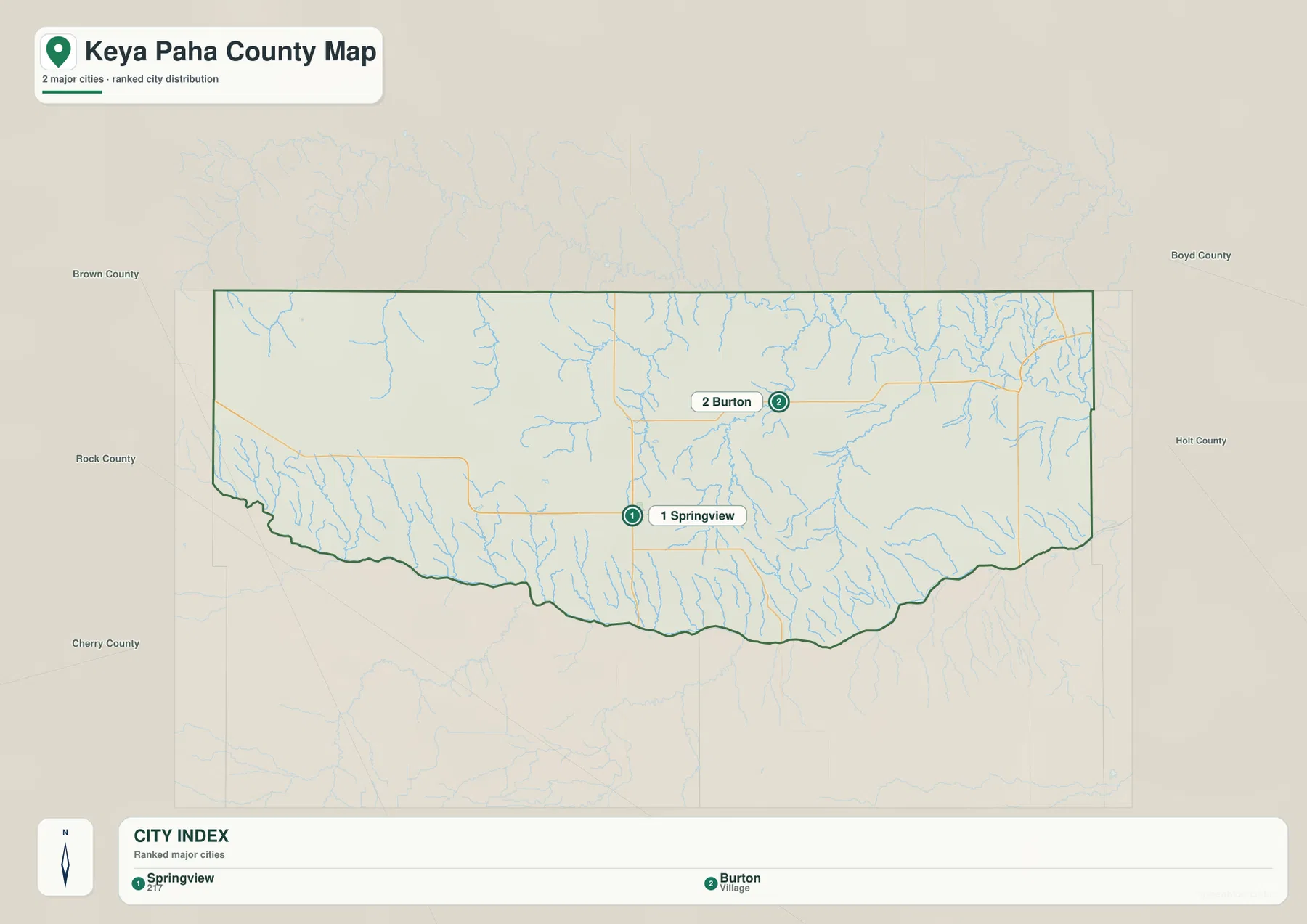
The city-distribution map is strikingly simple. It ranks Springview first and Burton second, showing how lightly settled the county is. Springview has an index value of 217 printed beside its name, while Burton is labeled as a village without a separate numeric value on the graphic. Those labels are best treated as part of the supplied map rather than a live population table; current population questions should be checked against recent Census data.
The two settlements also occupy different geographic settings. Springview lies near the middle of the county’s southern half and close to the U.S. 183–Highway 12 road junction. Burton is farther northeast, within a landscape crossed by Burton Creek and near the broader Keya Paha River drainage. Large areas of ranchland and stream-cut terrain lie between them, so the county is not organized around a continuous chain of towns.
Local history gives the pair an additional connection. Springview community records explain that Keya Paha County was created from the part of Brown County north of the Niobrara River in 1884. The following year Springview and Burton became the final two candidates for the county seat, and Springview won the election. The modern city map still places those two names at the center of the county’s settlement story.
The Niobrara shapes the south while the Keya Paha River drains the northeast
The Niobrara River is the easiest water feature to identify. It follows the entire southern side of the county in a broad series of bends and forms most of the county line there. Numerous short tributaries descend from the higher land to the north. Turtle Creek and Chimney Creek are labeled in the southwest, while Dry Creek appears farther east along the southern interior. The concentration of short valleys makes the southern margin look much more dissected than the central uplands.
The Keya Paha River occupies a very different setting in the northeast. It flows eastward across the upper-right part of the county and continues beyond the boundary. Camp Creek and Wolf Creek are labeled near this system, while Burton Creek and Spring Creek occupy long valleys farther south and west. Together they explain why the eastern half contains a much denser pattern of drainage lines than the higher western half.
Central Keya Paha County includes Holt Creek and East Holt Creek, two long channels that provide useful north–south references. Cottonwood Creek and Lost Creek appear farther west. The county therefore does not drain in one simple direction. Some valleys lead toward the Niobrara along the south, while others connect with the Keya Paha River or eastern tributary systems. That split is easiest to recognize when the water map is viewed together with the elevation surface.
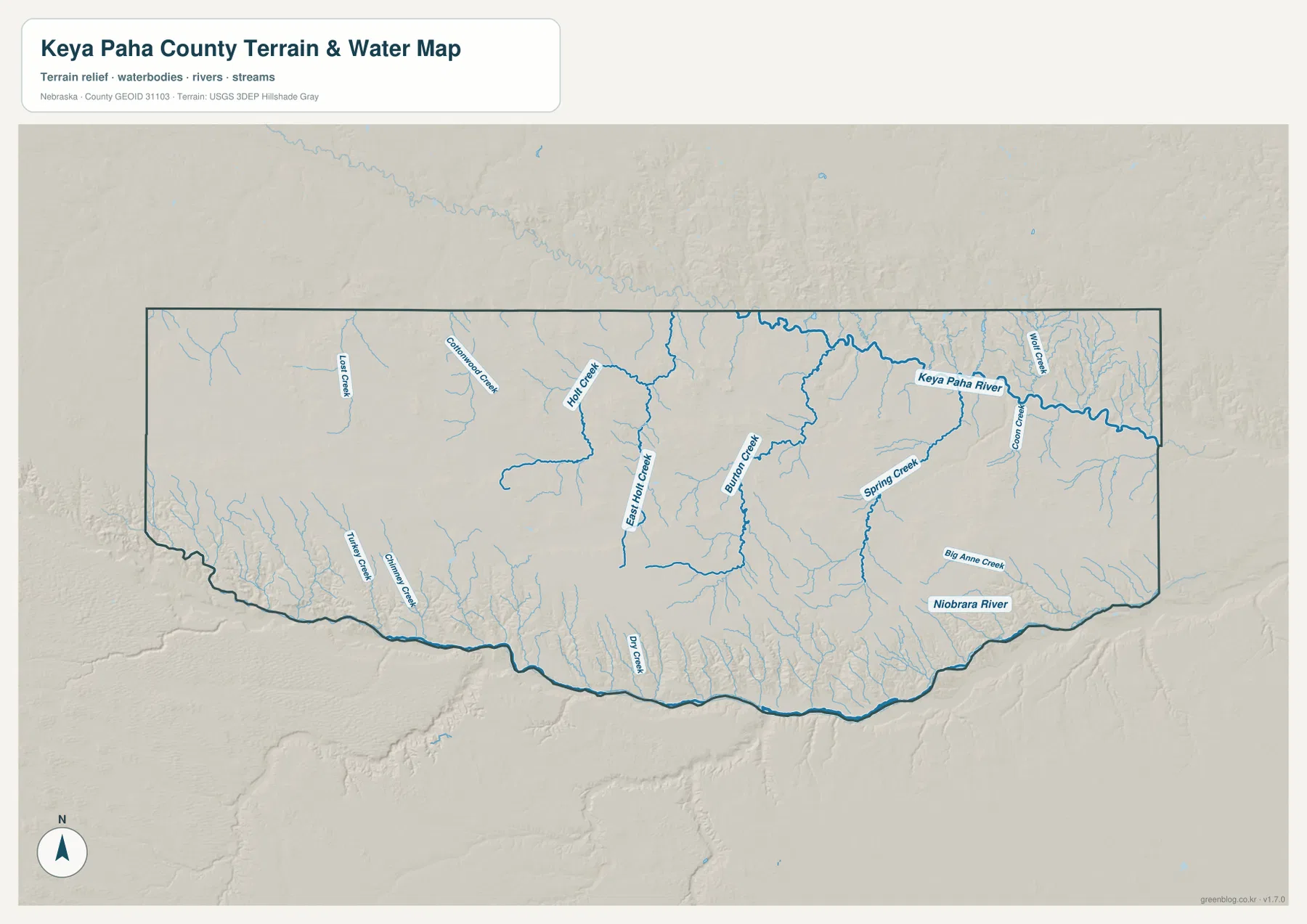
This water map is intended for general geographic reference. It is not a flood map, parcel map, real-time stream gauge, or access guide. River levels, bridge conditions, public access, and flood hazards can change and should be checked with the appropriate agency when those details matter. For map reading, the important point is how the two major rivers and many smaller creeks organize the county’s terrain.
Elevation falls from 807-meter western uplands toward lower eastern valleys
The supplied elevation map gives an actual county-wide range of about 536 to 807 meters, with a mean near 692 meters. Brown and orange colors dominate the west and northwest, while green becomes increasingly common toward the east and northeast. The difference between the mapped high and low points is roughly 271 meters, a substantial amount of local relief for a county often viewed simply as ranch and prairie country.
The Niobrara corridor is particularly clear. A long green lowland follows the southern boundary, and dozens of narrow tributary valleys cut northward into higher terrain. In the western half, brown uplands can lie close to the green river floor, producing sharp local transitions. Farther east, the entire landscape becomes lower, although the tributaries still create deep branching valleys.
The northeastern corner has its own complex lowlands around the Keya Paha River and its tributaries. Green channels branch through the surface while narrow ridges remain between them. Burton sits within this more heavily dissected eastern setting, whereas western Keya Paha County contains broader and more continuous high ground. The water and elevation maps line up closely enough that most named streams can be traced as green corridors even without reading their labels.
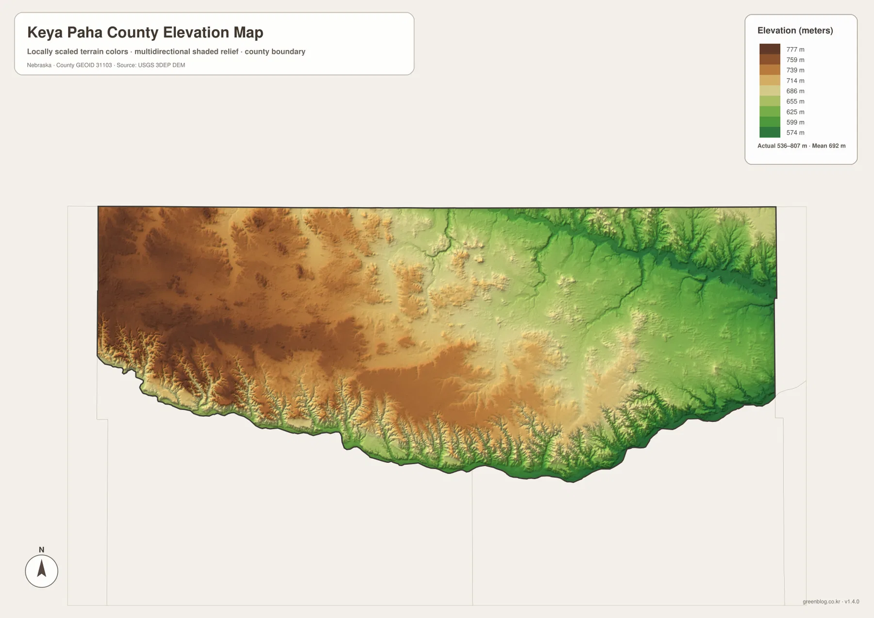
The elevation surface is generalized for county-scale comparison. It is not survey-grade information for a parcel, building site, drainage design, road grade, or engineering project. Those tasks require current detailed elevation data such as the USGS 3D Elevation Program and, where appropriate, professional measurements. For regional study, the 536–807 meter range clearly shows how much the western uplands, river bluffs, and eastern valleys differ.
Springview sits between the Niobrara bluffs and broader northern uplands
Springview is not directly on the Niobrara River. Several miles of rolling land, short creeks, and steep tributary valleys lie between the community and the southern boundary. North of Springview, the uplands are broader and the road pattern becomes straighter. This contrast is especially easy to see by switching between the county map and the elevation map.
East of Springview, Burton Creek and Spring Creek lead toward the more dissected eastern half of the county. Farther northeast, the Keya Paha River becomes the dominant natural reference. Burton lies closer to that eastern drainage setting, while Springview remains the better transportation and government reference because of U.S. 183 and Highway 12. The two communities therefore help describe different parts of the same county.
Springview’s own community history describes the village as centrally located within Keya Paha County and records the 1885 county-seat election. The same source notes that the Niobrara forms the county’s southern side and remains an important natural feature in the region. On the modern maps, those facts appear visually: Springview sits well inside the county while the river traces a separate winding line along the south.
The Niobrara boundary is easier to remember than the county outline itself
The southern boundary is one of the county’s most recognizable features because it follows the Niobrara River rather than a straight survey line. The general county map shows the green boundary bending repeatedly from west to east, and the water map places the river in the same position. Instead of memorizing the irregular outline, a reader can simply remember that the Niobrara defines the south.
The elevation map adds another layer to that boundary. The river floor appears as a low green strip, while higher land rises immediately to the north through a dense series of tributary ravines. The contrast is strongest in the western half, where high brown terrain approaches the river more closely. In the east, overall elevations are lower but the branching valley pattern remains pronounced.
This makes the Niobrara a useful reference for roads as well. U.S. 183 leaves Springview and heads south toward the river, Rocky Ford marks the western side near the boundary, and Highway 137 provides another reference farther east. Using the river first and the roads second creates a much clearer mental map than trying to memorize individual county-line bends.
Choose the map by whether you need roads, settlements, water, or relief
The general county map is the best first choice for Springview, Burton, U.S. 183, Highway 12, Highway 137, Highway 7, and the surrounding county boundaries. The city-distribution map is intentionally much simpler and is useful when the main question is how sparse settlement is and where Springview and Burton sit relative to one another.
For physical geography, the terrain-and-water map provides the most useful named detail. It follows the Niobrara River, Keya Paha River, Holt Creek, Burton Creek, Spring Creek, Turtle Creek, and many smaller tributaries. The elevation map removes much of that labeling and emphasizes height instead, making the western uplands, southern river bluffs, and lower eastern terrain easy to compare.
A practical study sequence is to locate Springview and the main highways first, trace the Niobrara and Keya Paha rivers on the water map, and then compare those same areas with the elevation surface. The WebP images on the page are convenient previews, while the original JPG files are better for enlarging small labels or printing. These are general-reference products, so legal boundaries, flood determinations, live road conditions, surveying, and engineering work should use the latest authoritative source for the specific task.
Frequently Asked Questions
Where is the Keya Paha County seat?
Springview is the county seat. Keya Paha County government and Springview community sources identify it as the administrative center, and the general map shows it near the U.S. 183–Highway 12 junction. Local history records that Springview defeated Burton in the 1885 county-seat election.
Why is the southern county line so irregular?
Most of the southern boundary follows the Niobrara River. The county and water maps show the boundary bending with the river rather than following a straight survey line. On the elevation map, the same corridor appears as a low green strip with many steep tributary valleys descending from the north.
Can the 536–807 meter elevation range be used for surveying or construction?
No. The range is a generalized county-scale summary intended to compare high western uplands with lower river valleys and eastern terrain. Parcel surveys, construction, drainage design, and road engineering require current detailed elevation data and professional measurements rather than this regional reference map.
Map File Information
The county, city-distribution, terrain-and-water, and elevation maps are available together in one ZIP file. It contains four original high-resolution JPG maps suitable for detailed viewing and printing.
- Included Files: County map, city-distribution map, terrain-and-water map, elevation map
- File Type: JPG files in a ZIP archive
Related Maps
Sources and references
These official and public sources provide additional context for Keya Paha County government, Springview history, roads, administrative boundaries, waterways, and elevation. The maps on this page are simplified for readable regional reference, so legal, engineering, and current-condition decisions should be checked against the original authoritative datasets and notices.
- Keya Paha County, Nebraska official website – county government information
- Village of Springview – History – county formation and Springview county-seat history
- Nebraska Department of Transportation – state highways and U.S. 183 / Highway 12 references
- U.S. Census Bureau TIGER/Line – administrative boundary and geographic reference data
- USGS National Hydrography – river and stream data
- USGS 3D Elevation Program – elevation data
Green Map creates custom-edited map images using open geographic data sources such as geoBoundaries, Natural Earth, OpenStreetMap, and government open data. These maps are edited visual materials, not raw data files, and are provided for education, documents, presentations, and graphic reference.