Hayes County occupies a quiet part of southwestern Nebraska where small communities are separated by long stretches of rural land. Hayes Center provides the main interior reference point, while Hamlet sits near the southwest edge along U.S. 6. The maps on this page make that sparse settlement pattern easier to understand by adding roads, creek valleys, and elevation. High-resolution JPG versions of the map files are also available in one downloadable ZIP for printing or closer inspection.
The county becomes much more interesting when the settlement map is compared with the terrain sheets. Western and northwestern areas stand higher, while a web of drainage valleys cuts progressively lower ground toward the east and south. Red Willow Creek dominates the eastern side, Blackwood and Little Blackwood creeks cross the interior, and several smaller channels divide areas that look almost empty on the city map. That contrast between few towns and many natural corridors is one of the defining features of Hayes County.
Table of Contents
Start with Hayes Center, then trace the roads toward the county edges
The general county map makes Hayes Center the easiest place to begin. It lies a little east of the county midpoint, where Nebraska Highway 25 and several local roads create a recognizable junction pattern. From there, roads extend west into broad agricultural country, north toward the Lincoln County side, and south toward the lower parts of the county. The map is useful because it provides enough surrounding context to show how Hayes Center functions as an internal anchor even though it is a very small community by urban standards.
Hamlet occupies a very different setting. It appears close to the southwestern corner beside U.S. 6, the route that approaches from the Wauneta direction and continues along the southern part of the region. A reader using the map for orientation can quickly see that Hamlet is not simply another stop near Hayes Center. The two communities are separated by a large rural interior, and the road network between them is made up of several north-south and east-west connections rather than one short direct corridor.
The wider frame also matters. The city sheet labels neighboring counties around the Hayes boundary, including Lincoln, Dundy, Frontier, Red Willow, Hitchcock, Perkins, and Chase. Those names help place Hayes County within southwestern Nebraska without requiring a separate statewide map. Along the south, Palisade deserves special attention because Nebraska state references identify the village as extending into both Hayes and Hitchcock counties. It is a useful reminder that a community can sit on an administrative edge even when the county border on a simplified map looks perfectly clear.
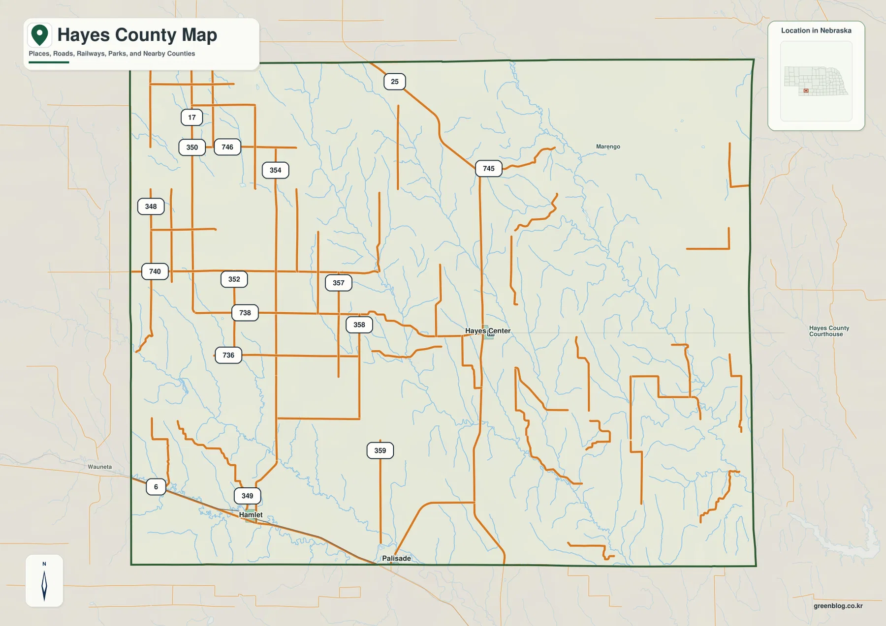
A number of smaller labels and numbered roads appear on the general sheet as well. They help with relative location but should not be treated as a live navigation layer. Seasonal road conditions, construction, closures, and the exact status of small rural roads can change. For actual driving, use the county map to understand direction and context, then confirm the route with current highway or local road information.
A two-place city index reveals how sparse the settlement pattern is
The city location map highlights only Hayes Center and Hamlet in its ranked index. Hayes Center appears as the first location and Hamlet as the second, with a large open area between the two markers. This is a very different visual pattern from counties where several towns form a chain along one river or highway. In Hayes County, the simplified settlement layer emphasizes distance, rural space, and the importance of roads that connect isolated communities across the interior.
Because the city sheet removes most road labels and terrain color, it is particularly good for comparing position. Hayes Center is slightly east of center, while Hamlet is pushed close to the southwest boundary. Once those two points are fixed in mind, the other maps become easier to interpret. The road sheet explains how they are connected, the water sheet shows the valleys crossing the space between them, and the elevation sheet explains why the surface is far more varied than the sparse city pattern might suggest.
Hayes County’s official website identifies Hayes Center as the location of county government offices. The county’s historical page states that Hayes County was created in 1877, formally organized late in 1884, and that Hayes Center was founded the following year with the county-seat role in mind. These facts add useful context to the map: Hayes Center is significant because it is the administrative focus of a large rural county, not because it forms a dense urban center.
Hamlet has its own geographic role. Hayes County planning material describes the community, originally called Hudson, as established in 1890 and located in the southwest part of the county along U.S. Highway 6. That description matches the position shown on the map. For a reader studying local settlement geography, the two communities therefore represent two distinct situations: an interior county seat and a small highway settlement near the edge.
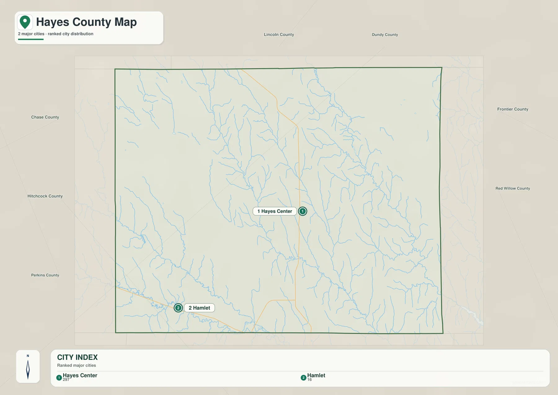
Palisade is a good example of why this city index should not be read as a complete legal list of every community associated with the county. The Nebraska Blue Book notes that Palisade lies in both Hayes and Hitchcock counties. It appears near the southern boundary on the general map, yet the simplified city index contains only Hayes Center and Hamlet. The two sheets serve different purposes, and the broader administrative sources are the better reference when a boundary-spanning community matters.
Red Willow Creek and the Blackwood creeks carve up the eastern half
The terrain and water map changes the impression of Hayes County immediately. Instead of a large open rectangle, the eastern half becomes a dense network of valleys. Red Willow Creek is one of the most prominent named channels, running through the northeastern and eastern part of the county with many short tributaries feeding into it. Sand Creek and Dry Creek appear closer to the eastern boundary, while the central area contains the long valley of Skunk Creek.
Farther west, Little Blackwood Creek and Blackwood Creek form another important pair of named drainage corridors. Their valleys are distinct even though the names are similar, and numerous smaller channels join them from the surrounding uplands. This is especially clear where shaded relief exposes the cut of the valleys. Areas that look nearly featureless on the city map become a repeating pattern of ridges and shallow-to-deeper draws when the water layer is added.
The southwest has a different set of labels. Sinking Water Creek crosses part of that corner, Frenchman Creek appears near the lower edge, and the Culbertson Canal is shown along the south. These features should be used as geographic references rather than as a guide to current flow, irrigation operations, or flood conditions. The map is designed to show where named waterways and terrain breaks occur, not to report real-time water levels or legal water-management boundaries.
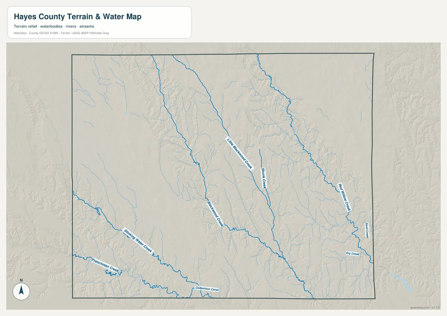
The shaded surface adds another layer of information. Eastern tributaries branch repeatedly toward Red Willow Creek, while the Skunk Creek corridor forms a long, clear incision through the central area. Western ground is broader in places, but the Blackwood creeks and Sinking Water Creek still cut noticeable valleys. The pattern is important because it connects directly with the elevation map: many of the green, lower fingers on that sheet correspond to the channels visible here.
Elevation falls from high western ground into lower eastern valleys
The elevation map reports an actual county-scale range from about 792 to 1,041 meters, with a mean near 921 meters. That produces a mapped spread of roughly 249 meters between the lowest and highest values. Brown and dark tan dominate much of the west and northwest, while colors transition through lighter tan and green toward the east and southeast. The broad pattern is straightforward: the western side stands higher, and many of the lowest corridors are associated with the drainage network farther east and south.
The surface is not a simple tilted plane, however. Creek valleys cut into high ground in the west, and ridges remain between low channels in the east. The branching green forms around Red Willow Creek show this clearly. Little Blackwood Creek and Blackwood Creek also carve lower paths through otherwise elevated terrain, while the southwestern drainage near Hamlet and the Frenchman Creek area creates its own band of lower relief.
Hayes Center sits in an intermediate part of the county rather than at either elevation extreme. Comparing the city and elevation sheets shows higher terrain expanding to the west and a more dissected set of valleys toward the east and southeast. Hamlet, by contrast, lies near the lower southwestern corridor associated with U.S. 6 and the drainage network near the county edge. The difference helps explain why the two communities can occupy the same county but appear in noticeably different terrain settings.
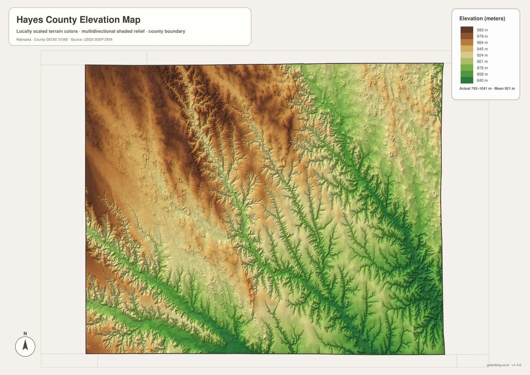
Use this sheet for regional relief, not parcel-level measurements. The colors and shaded relief are excellent for identifying the broad western upland, the eastern valley network, and the way streams dissect the surface. They are not a replacement for survey data, engineering-grade elevations, or a site-specific grading plan. USGS 3D Elevation Program data and professional surveys are the appropriate sources when precise heights are required.
Boundary communities and neighboring counties add useful context
Hayes County can look self-contained when only the dark county outline is considered, but the surrounding labels show how closely it relates to neighboring areas. Lincoln and Dundy counties lie to the north side of the broader frame, Frontier and Red Willow are to the east, Hitchcock is south, and Perkins and Chase appear to the west. These labels are especially helpful for readers who know southwestern Nebraska by county names rather than by individual small towns.
Palisade illustrates the difference between a legal boundary and a community landscape. Nebraska’s Blue Book notes that the village is in both Hayes and Hitchcock counties. On the general map its label sits near the southern edge, where a casual glance might otherwise make it seem entirely inside or entirely outside Hayes County. When administrative detail matters, the boundary should be checked against official data rather than inferred from the location of a single text label.
Natural features ignore county lines as well. Red Willow Creek and other drainage corridors continue beyond the border, while roads such as U.S. 6 connect Hayes County directly with places outside it. For geography study, it is useful to follow those features across the boundary. For statistics, county government, property records, and other administrative questions, the dark county line becomes the critical reference instead.
Pick the map by the question, not by the amount of detail
The general county map is the best choice when the task is to locate Hayes Center, Hamlet, Palisade, U.S. 6, Highway 25, or the main network of numbered roads. It balances names, transportation, streams, and boundaries without emphasizing one theme too heavily. The city map is simpler and better when the only question is where the two highlighted settlements sit relative to each other and to the county edges.
Choose the terrain and water map when creek names, drainage directions, and valley shapes matter. Red Willow Creek, Skunk Creek, Little Blackwood Creek, Blackwood Creek, Sinking Water Creek, Frenchman Creek, and several other channels can be followed much more clearly there. Choose the elevation map when the main interest is the high western ground, the lower eastern valleys, or the county’s 792–1,041 meter mapped range.
For a classroom project or county comparison, a useful sequence is to begin with the general map for names and roads, switch to the city sheet to establish settlement spacing, and then compare the water and elevation sheets. That approach turns several isolated observations into one geographic story. Hayes Center becomes the interior administrative reference, Hamlet becomes the southwest highway settlement, and the large rural space between them becomes a landscape structured by creek valleys and a west-to-east elevation change.
The downloadable JPG files are preferable to the on-page previews when small labels or shaded-relief detail need to be printed. One map can be used by itself, or all four can be kept together for side-by-side comparison. These are general reference maps, so legal boundary determinations, land surveying, engineering design, and current road restrictions should always be checked with the appropriate official source.
Frequently Asked Questions
Where are Hayes Center and Hamlet relative to each other?
Hayes Center is slightly east of the county midpoint, while Hamlet is close to the southwest boundary along U.S. 6. The city map shows a large rural gap between the two. Use the map for orientation and relative position; exact driving distance and travel time depend on the route and should be checked with current road information.
Why does Palisade appear on the general map but not in the two-place city index?
The city sheet is a simplified ranking that highlights Hayes Center and Hamlet. Palisade sits near the southern county line and Nebraska state references identify it as a village that extends into both Hayes and Hitchcock counties. The general map includes it as useful boundary context, while the city index is intentionally narrower.
Can the 792–1,041 meter elevation range be used for surveying?
No. The elevation sheet is intended to show county-scale relief, including the high western uplands and the lower creek valleys to the east and south. Parcel elevations, construction grades, drainage design, and other precise work require current authoritative elevation data and, when appropriate, a professional survey.
Map File Information
The ZIP package contains the same county, city, terrain-and-water, and elevation maps discussed on this page as original high-resolution JPG files.
- Included Files: County map, city location map, terrain and water map, elevation map
- File Type: JPG files in a ZIP archive
Related Maps
Sources and references
The following official and public sources are useful for checking county administration, history, boundary context, hydrography, and elevation. The maps on this page are simplified for readable geographic reference, so specialized or current questions should be verified against the appropriate source.
- Hayes County, Nebraska official website – county offices and Hayes Center administrative information
- Hayes County Historical Information – county formation and Hayes Center history
- Nebraska Legislature Blue Book – Local Government – county and Palisade administrative context
- U.S. Census Bureau TIGER/Line – county boundary and geographic reference data
- USGS National Hydrography – river and stream reference data
- USGS 3D Elevation Program – elevation data
Green Map creates custom-edited map images using open geographic data sources such as geoBoundaries, Natural Earth, OpenStreetMap, and government open data. These maps are edited visual materials, not raw data files, and are provided for education, documents, presentations, and graphic reference.