Hamilton County occupies a largely agricultural part of central Nebraska between the Platte River edge in the northwest and the Big Blue drainage to the east and south. Aurora is the county seat and largest community, while Hampton, Giltner, Phillips, Marquette, Hordville, and Stockham are scattered among broad rural blocks. The west and southwest stand higher, and the land gradually drops into the Platte corridor and the lower creek valleys farther east.
This page explains Aurora and the smaller communities, U.S. 34, Highway 14, Interstate 80, the Platte and Big Blue rivers, Lincoln Creek, Beaver Creek, and an elevation range of about 496 to 585 meters. The original high-resolution JPG map files can also be downloaded together in a ZIP when larger labels, printable copies, or classroom material are needed.
Table of Contents
Aurora is the county seat and the main road and service center
Aurora is the Hamilton County seat and by far the largest city represented on the supplied maps. The Nebraska Association of County Officials says the county boundaries were authorized in 1867, the county was formally organized in 1870, and the name honors Alexander Hamilton, the first U.S. Secretary of the Treasury. Aurora’s location near the center-south of the county makes it the clearest reference point for roads and surrounding towns.
Phillips and Giltner lie west of Aurora, Hampton is to the east, and Marquette and Hordville occupy the northern half. Stockham appears farther south on the general county map even though it is not included in the six-city ranking graphic. The result is a dispersed settlement pattern rather than one continuous built-up corridor.
The current Nebraska Counties profile reports that about 91 percent of Hamilton County land is classified as agricultural. That helps explain why large spaces separate the towns on the map and why the county road network is much more extensive than its urban footprint. The supplied maps are not land-cover or parcel-use products, however, so they should not be used to identify the use of an individual property.
U.S. 34 and Highway 14 cross at Aurora while Interstate 80 runs farther south
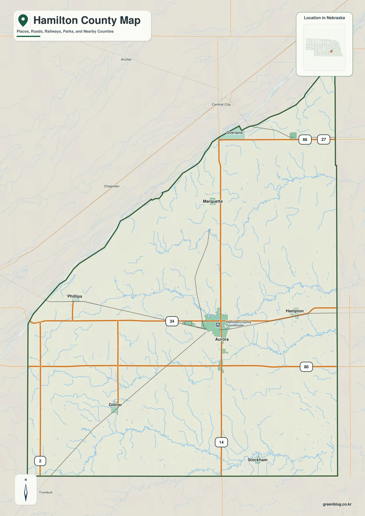
U.S. 34 is the most obvious east-west road through the inhabited middle of the county. It approaches Aurora from the Phillips area and continues toward Hampton, while Highway 14 crosses Aurora from north to south and provides a direct reference for Marquette and Stockham. Rail lines follow the same broad central transportation geography.
Interstate 80 crosses the southern portion of Hamilton County and carries long-distance east-west traffic. Around Aurora, Highway 14 connects the I-80 side of the county with U.S. 34 and the city center. Additional state and county roads extend toward Hampton, Hordville, Giltner, and the rural northeast.
The county road pattern is relatively straight across the broader lowland around Aurora and the east, but it becomes more irregular across the higher west and southwest where small tributary valleys interrupt the rural grid. Current road surfaces, construction, closures, and travel times should be checked with live Nebraska transportation information before a trip.
Six ranked communities show how strongly Aurora outweighs the smaller villages
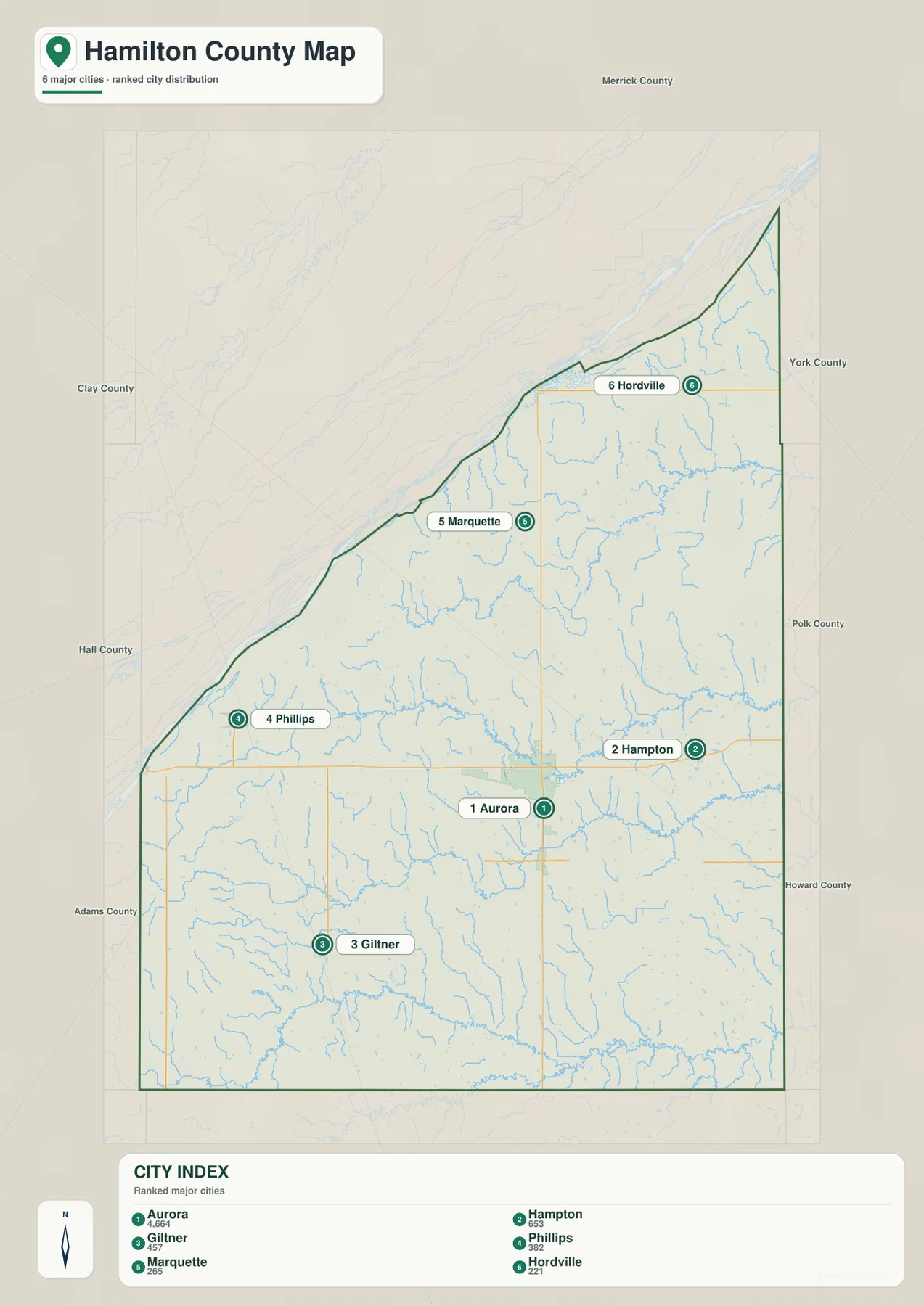
The city distribution map ranks Aurora first, followed by Hampton, Giltner, Phillips, Marquette, and Hordville. Aurora occupies the central-southern part of the county, Hampton lies east, Giltner and Phillips are west, and Marquette and Hordville are farther north. The six markers spread across much of the county instead of forming a single cluster.
No connector lines or mileage labels appear on the supplied city map. The useful comparison is therefore positional rather than distance-based. Pairing this graphic with the road map makes it easy to see which communities relate most closely to U.S. 34, Highway 14, or the northern county roads without inventing straight-line or driving distances.
The printed ranking values are 4,664 for Aurora, 653 for Hampton, 457 for Giltner, 382 for Phillips, 265 for Marquette, and 221 for Hordville. They belong to the supplied city graphic rather than a continuously updated population table. Current official counts should be checked with the U.S. Census Bureau or Hamilton County sources when needed.
Platte River forms the northwest edge while the Big Blue system drains the east and south
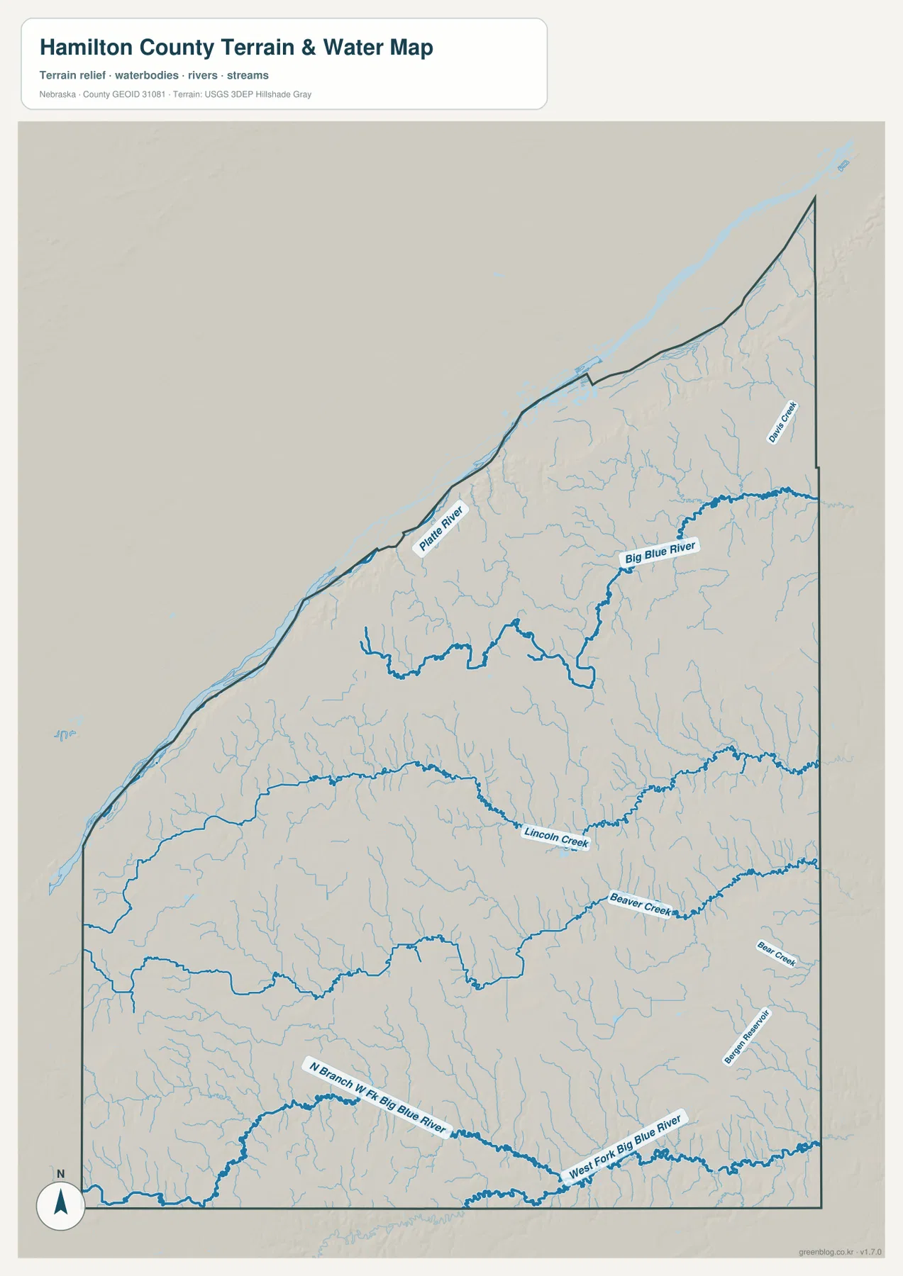
Platte River is the largest water feature along the county’s northwest side. Its broad low corridor follows the irregular boundary and is visibly different from the smaller interior streams. The same lowland also stands out as one of the darkest green areas on the elevation map.
Big Blue River defines the major drainage on the northeastern and eastern side. Dry Creek and numerous unnamed tributaries descend from the interior toward the Big Blue valley, cutting shallow but closely spaced channels through agricultural land. The river’s low corridor becomes especially clear near the eastern boundary.
Lincoln Creek crosses the central county, and Beaver Creek creates another long eastward valley farther south. Near the southern boundary, North Branch West Fork Big Blue River and West Fork Big Blue River form additional low routes. Together these waterways show that Hamilton County sits between the Platte system and the broader Big Blue basin.
This water map is intended for geographic reference. It does not define flood zones, legal water rights, parcel boundaries, present streamflow, channel depth, navigability, or public access. Those questions require current information from USGS and the responsible local or state agencies.
Western ground rises about 89 meters above the lowest Platte and eastern valleys
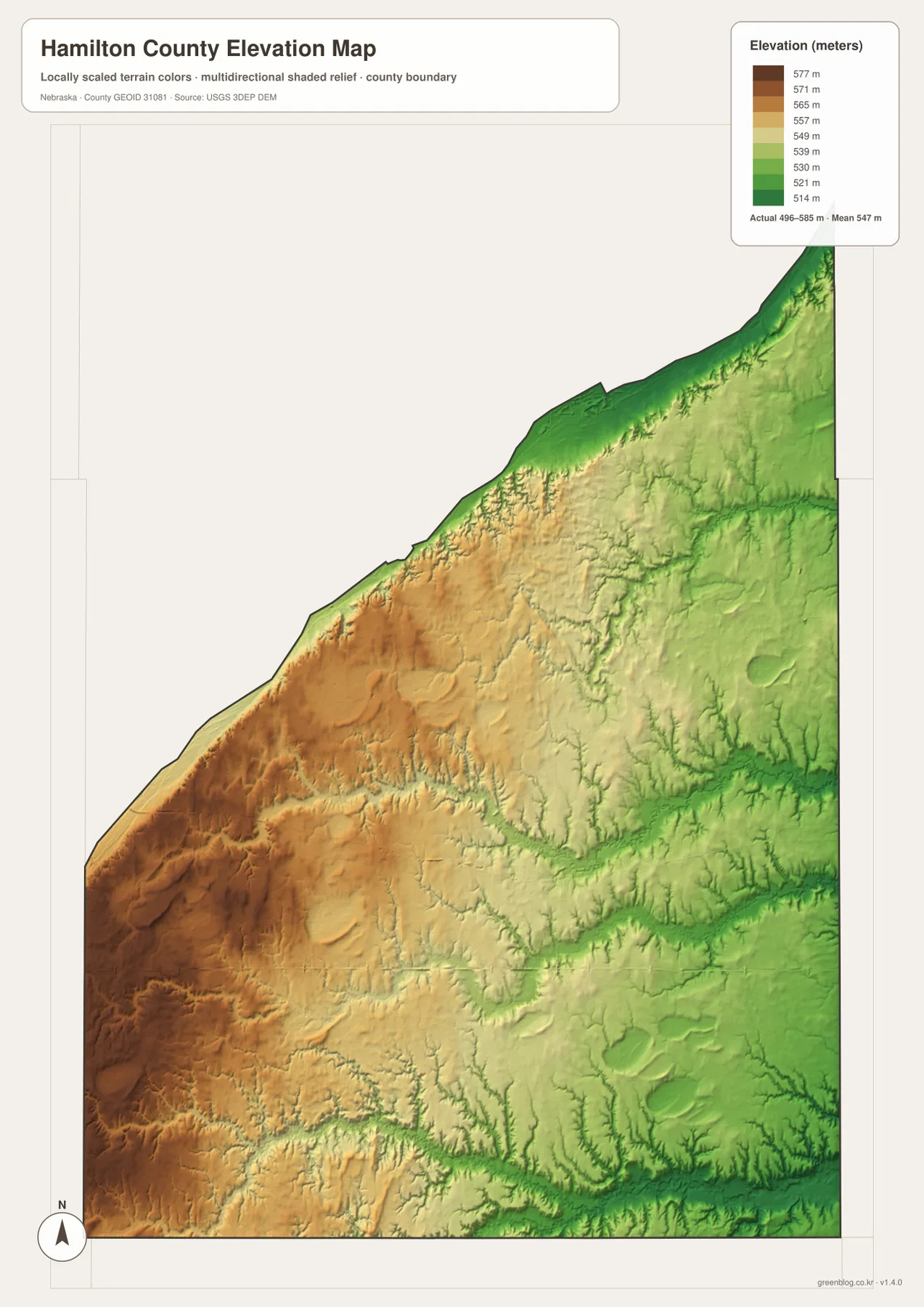
The elevation map reports an actual county-wide range of approximately 496 to 585 meters, with a mean near 547 meters. The highest brown terrain covers much of the west and southwest, while green colors increase toward the Platte boundary and the eastern drainage country. Total mapped relief is about 89 meters.
Small tributaries cut shallow valleys through the western high ground before reaching lower parts of the county. Lincoln Creek and Beaver Creek form longer green corridors through the middle and south, and Big Blue River occupies a broader low area farther east. The match between drainage lines and elevation lows is especially clear when the water and elevation maps are viewed together.
The southern West Fork Big Blue system creates another distinct low route, so Hamilton County is not simply a smooth west-to-east slope. Instead, several river and creek corridors interrupt the higher agricultural surface and create multiple low bands around the county.
The elevation colors are scaled locally for Hamilton County and should be used only for comparisons within this map. Similar colors on another county map may represent different absolute heights. The generalized surface is not survey-grade information for engineering, construction, drainage design, or property work.
County government moved from Orville City to Aurora after years of contested elections
The Plainsman Museum says Hamilton County’s boundaries were approved in 1867 and the county was formally organized by Governor David Butler in 1870. Orville City became the first county seat and hosted many early county institutions, including elections, a post office, school activity, a newspaper, and the first county fair.
As settlement expanded, residents repeatedly debated moving the county seat to Aurora. Several elections and legal disputes followed before county government finally shifted to Aurora in the late 1870s. A courthouse built there in 1877 burned in 1894, and the red-stone courthouse completed in 1895 still stands on Aurora’s courthouse square.
The 1879 railroad helped turn Aurora into Hamilton County’s permanent center
The Plainsman Museum’s Aurora history dates the town to 1871 and notes that the Burlington & Missouri River Railroad arrived in 1879. Telegraph service, regular trains, and improved mail service followed in the same period, reinforcing Aurora’s role as a commercial and administrative center.
Aurora is also home to the Plainsman Museum, which preserves Hamilton County history from pioneer settlement through agriculture, schools, transportation, and community life. The Nebraska State Historical Society traces the local historical society to 1935 and says the present museum facility opened in 1976. It provides useful historical context for the towns and rural landscape shown on these maps.
Use Aurora and the Platte boundary as the two easiest map anchors
For basic orientation, locate Aurora and follow U.S. 34 west toward Phillips and east toward Hampton. Highway 14 then leads north toward Marquette and south toward Stockham, while Giltner and Hordville complete the broader settlement picture.
For physical geography, begin at Platte River along the northwest boundary, then move across the county toward Big Blue River. Lincoln Creek and Beaver Creek occupy the space between those larger drainage settings, and the elevation map shows the western high ground gradually breaking into lower green valleys.
The downloadable high-resolution JPG files are especially useful when small county-road labels or tributary names are difficult to read in the web previews. Starting with Aurora’s roads and then comparing the Platte-Big Blue drainage pattern with the elevation surface gives a clear overview of Hamilton County.
Frequently Asked Questions
Does the city map show distances from Aurora to the other communities?
No. The supplied city map ranks and locates Aurora, Hampton, Giltner, Phillips, Marquette, and Hordville, but it does not include connector lines or mileage. Use the road map for relative position and a current routing service when actual driving distance is needed.
Where is the lowest terrain in Hamilton County?
The broadest low areas occur along the Platte River boundary in the northwest and in the Big Blue and major creek valleys farther east and south. The mapped elevation range is about 496 to 585 meters, while the western and southwestern interior is generally higher.
Was Aurora always the county seat?
No. Orville City was the original county seat. After repeated elections and disputes in the 1870s, county government moved to Aurora, where the present courthouse was completed in 1895.
Map File Information
The ZIP contains the original high-resolution JPG files for the Hamilton County boundary and road map, city distribution map, terrain and water map, and elevation map.
- Included Files: Use only the versions confirmed in the article and supplied images
- File Type: Use the confirmed download contents
- Intended Use: Printing, education, presentations, and map-based projects
Related Maps
Sources and references
- Nebraska Association of County Officials – Hamilton County
- Hamilton County, Nebraska – Official Website
- Plainsman Museum – Hamilton County History
- Plainsman Museum – Aurora History
- USGS National Hydrography
- USGS 3D Elevation Program
These maps are intended for geographic reference. For legal boundaries, land ownership, flood determinations, water rights, road conditions, construction, surveying, or other decisions requiring current authoritative information, consult Hamilton County and the responsible state or federal agency.
Green Map creates custom-edited map images using open geographic data sources such as geoBoundaries, Natural Earth, OpenStreetMap, and government open data. These maps are edited visual materials, not raw data files, and are provided for education, documents, presentations, and graphic reference.