Arthur County sits in west-central Nebraska’s Sandhills, where the county seat of Arthur is surrounded by broad ranch country, repeated dune-like ridges, and many small lakes. Nebraska Highways 61 and 92 provide the clearest road references on the map, while the elevation view shows higher ground across the west and northwest and lower terrain toward the east and southeast. High-resolution map files are available for download in the section below.
This page combines the county road map, a city distribution map, a terrain-and-water view, and an elevation map. The original high-resolution JPG versions are also available together in a ZIP below, so the maps can be used at a larger size for printing, classroom material, or personal reference.
Table of Contents
Arthur is the single community at the center of a wide rural county
Arthur County lies in west-central Nebraska within the Sandhills region. Arthur County’s official website serves the county government from Arthur, and the Nebraska Association of County Officials also identifies Arthur as the county seat and principal incorporated village. That local pattern is reflected directly in the supplied city map, which selects Arthur as the only ranked major place.
The surrounding county labels help establish the wider setting. Grant County is north, McPherson County is east, Hooker County is southeast, Garden County is west, and Keith County lies to the southwest. The outer boundary is relatively simple, but the terrain inside it is not: hundreds of elongated Sandhills ridges give the county a textured surface even where roads and settlements are sparse.
Highways 61 and 92 make Arthur the main road reference
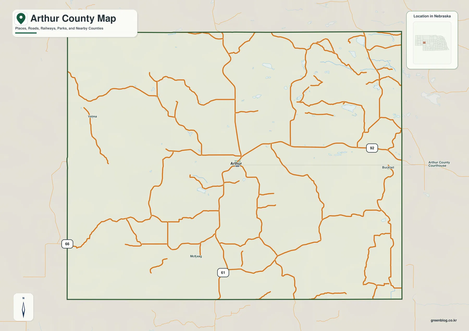
The road map places Arthur close to the center of the county. Nebraska Highway 61 approaches from the south, reaches the Arthur area, and continues north toward Grant County. Highway 92 approaches from the east and meets the local road network near Arthur. Nebraska Department of Transportation records for Arthur County confirm both 61 and 92 as the primary state-numbered highways shown on the county map.
Beyond those two highways, the map contains a network of widely spaced rural roads. Velma is labeled toward the western side, while Bucktail and the Arthur County Courthouse appear east of the county seat. Several roads curve or change direction as they cross the Sandhills, producing a very different pattern from the tight street grids found in more urban Nebraska counties.
The map is useful for general orientation, but it should not be treated as a live routing product. A short-looking line across the county may not match the usable road distance because drivers have to follow the available road network around hills, wet areas, and private land. Current Nebraska 511 information is the better source for closures, construction, and seasonal travel conditions.
Why the city map shows only Arthur
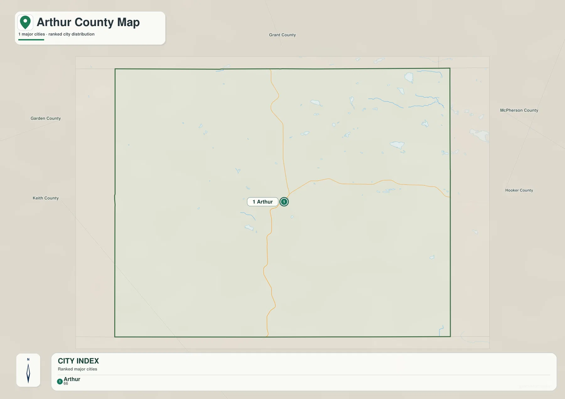
The city distribution map contains one ranked major place: Arthur. Because there is no second ranked city, the graphic does not draw a connector or display a city-to-city straight-line distance. That is an intentional result of the local settlement pattern rather than missing map content.
Arthur sits close to the intersection of the county’s most important numbered roads, making it the most practical reference point for the rest of the map. The Nebraska Legislature’s county information and the county government’s own website both identify Arthur as the county seat. From this central point, the county extends into large rural areas in every direction with very little continuous built-up land.
A one-place city map is especially useful here because it avoids giving small rural labels the same weight as an incorporated community. Historical names and ranch-area labels still help with local orientation, but they are not equivalent to a ranked city. The simplified city view therefore communicates the county’s unusually dispersed settlement pattern clearly.
Small Sandhills lakes are more prominent than large river channels
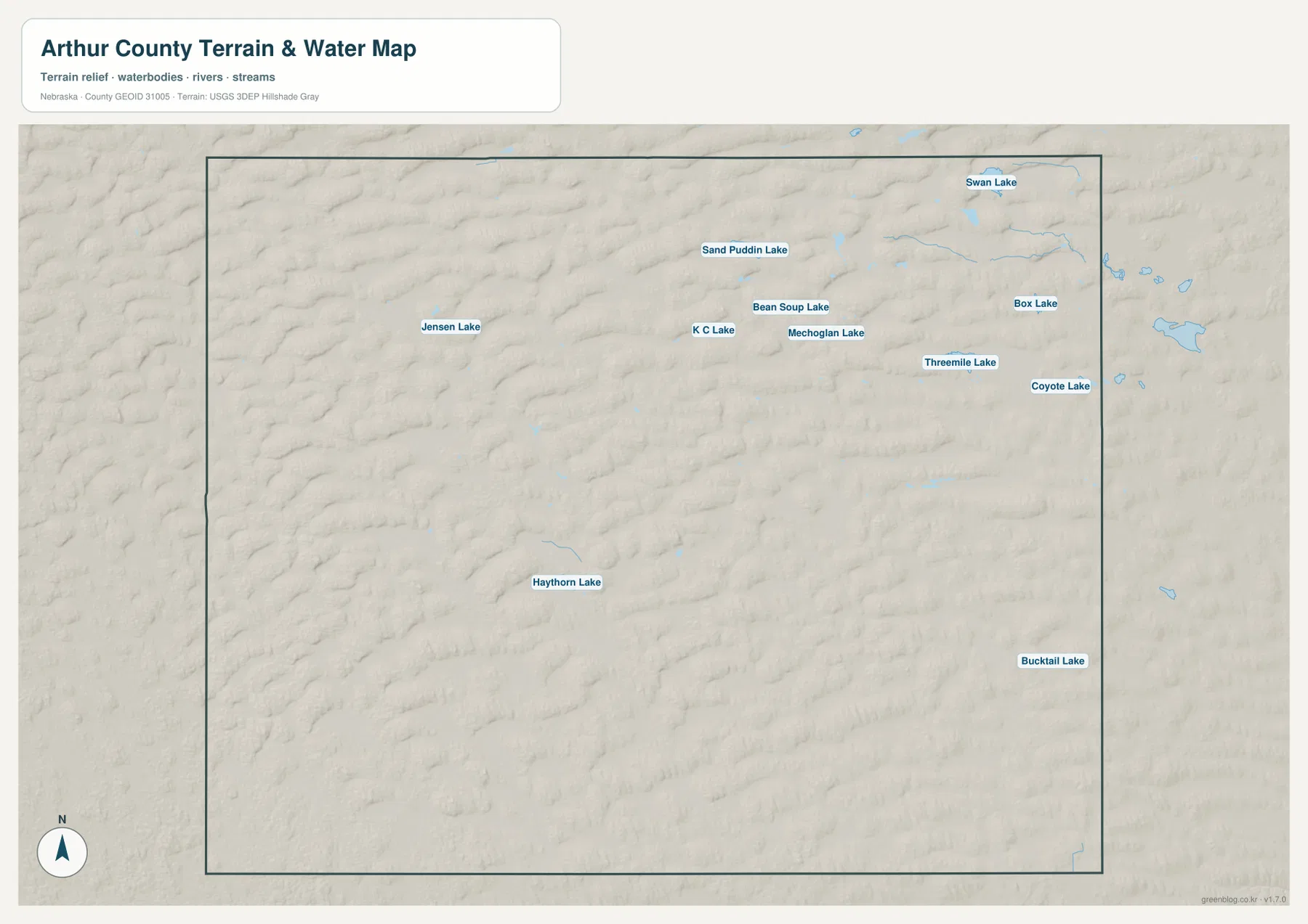
The water map is notable for its many small named lakes rather than a single dominant river. Swan Lake, Box Lake, and Coyote Lake appear in the northeast, while Threemile Lake, Mechoglan Lake, Bean Soup Lake, K C Lake, and Sand Puddin Lake form a loose cluster farther west. This concentration of blue water features gives the northern and northeastern part of the county a very different appearance from the drier-looking south.
Jensen Lake is isolated in the northwest, Haythorn Lake appears in the west-central to southwestern interior, and Bucktail Lake is labeled in the southeast. The lakes do not form one connected chain. Instead, they occupy separate low pockets between Sandhills ridges, which is one of the most useful relationships to notice when comparing this view with the elevation map.
The map does not show a large named river crossing the county from one side to the other. That makes Arthur County different from many Nebraska county pages where a major river provides the main geographic spine. Here, small lakes and local depressions are the more visible water features, while the rolling terrain itself dominates the landscape.
This is a geographic reference map, not a flood, water-right, fishing-access, or parcel map. A lake symbol does not establish public access or a constant water level, and the condition of small Sandhills lakes can change with weather and season. Current land-management and agency information should be checked before using a specific waterbody for recreation or field access.
Elevation ranges from about 1,035 to 1,241 meters
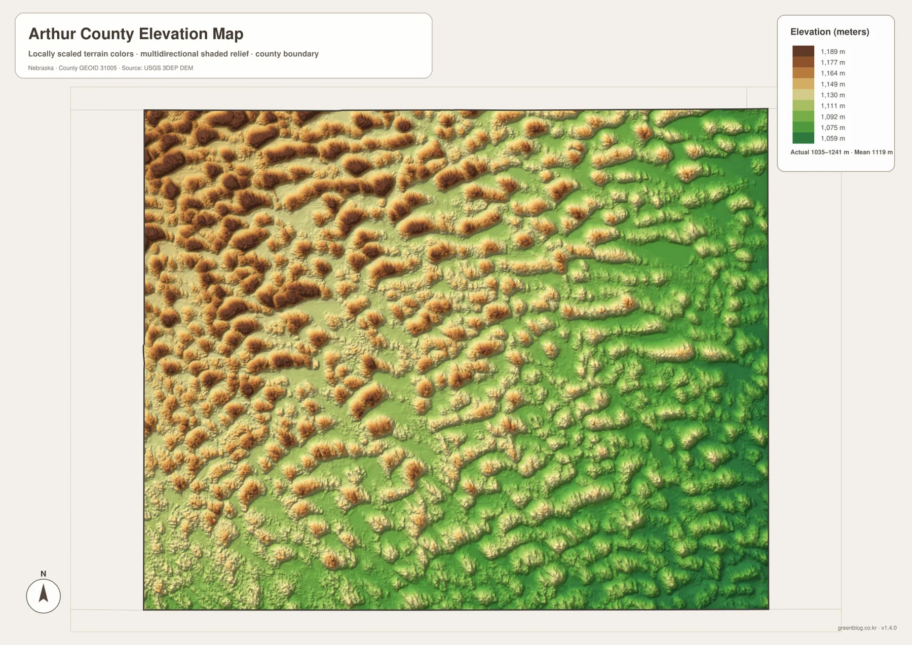
The elevation map reports an actual county-wide range of roughly 1,035 to 1,241 meters, with a mean near 1,119 meters. Higher tan and brown terrain is concentrated in the west and northwest, while greener lower ground becomes more common toward the east and southeast. The difference is only a little over 200 meters across the county, yet the relief looks pronounced because small ridges and hollows repeat continuously.
Rather than one mountain ridge, the map shows many rounded and elongated hills. The northwest contains the densest concentration of higher ridges, the central area mixes ridges with broader low pockets, and the eastern half contains larger areas of green between the hills. The same pattern continues into the south, where lower southeastern terrain is crossed by scattered higher ridges.
Comparing this view with the water map helps explain the lake pattern. Many small waterbodies occupy lower depressions between ridges, particularly in the northern half. The relationship is not identical for every lake, but the two maps together make it easier to see why water appears as separate pockets instead of as one continuous river corridor.
The elevation colors are scaled locally for Arthur County and are intended for relative comparison within this map. A similar color on another county map may represent a different height. The surface is also generalized and should not be used as survey-grade elevation for engineering, construction, drainage design, or property work.
Sandhills terrain shapes the road pattern and rural settlement
Putting the road and elevation maps side by side helps explain why the local network is so widely spaced. Roads cross long stretches of rolling Sandhills, and many of them bend or change direction rather than forming a perfectly regular grid. Outside the Arthur area, there are few concentrated settlements to create a dense web of local streets.
History Nebraska describes Arthur’s Baled Hay Church as a distinctive example of architecture within the Sandhills of west-central Nebraska. Its use of local grass and hay is a reminder that the same prairie landscape visible on the map has shaped local building traditions and ranch life. The county map therefore represents more than an administrative outline; the terrain is closely tied to how the area has been settled and used.
Arthur County was organized in 1913 after an earlier boundary proposal
Arthur County’s official history explains that boundaries for the future county were established in 1887, but the county did not formally organize until 1913. History Nebraska gives the same sequence and notes that Arthur became the county seat when the county was organized. The county was named for Chester A. Arthur, the twenty-first president of the United States.
The first permanent courthouse was built in 1914. Arthur County’s official site notes that the small 26-by-28-foot building became known as possibly the smallest courthouse in the United States before it was replaced by the present courthouse in the early 1960s. The modern county map labels the courthouse near Arthur, keeping that administrative history tied to a specific place on the map.
Which Arthur County map is most useful for your task?
For orientation, start with Arthur and the intersection of Highways 61 and 92. Then use the neighboring county labels to place Arthur County within west-central Nebraska. This general map is the best option when roads, the county outline, and scattered local place names need to be visible together.
For natural geography, begin with Swan Lake and the cluster of small northern lakes, then switch to the elevation view. The higher western ridges and lower eastern terrain become much easier to understand when the lake locations are compared with nearby depressions. The city map is the cleanest choice when the goal is simply to show where Arthur sits inside the county.
For printing or classroom use, the high-resolution JPG files in the ZIP are preferable to the smaller web previews. The county map emphasizes roads and boundaries, the city map isolates Arthur, the water map highlights named lakes, and the elevation map shows the repeated Sandhills ridges and the west-to-east change in relief.
Frequently Asked Questions
Why does the city map show only Arthur?
Arthur is the only ranked major place on the supplied city map and is the county seat. With no second ranked city, there is no appropriate city-to-city connector or straight-line mileage to display. The map is intended to show Arthur’s position within a very rural county.
Why are small lakes so prominent on the Arthur County water map?
The supplied water map emphasizes many separate Sandhills lakes, including Swan Lake, Sand Puddin Lake, Bean Soup Lake, Box Lake, and Bucktail Lake. They occupy low pockets among the county’s repeated ridges, so small waterbodies are more visually prominent here than a single large river corridor.
Can the 1,035-1,241 meter elevation range be used for surveying?
No. The range summarizes a generalized county-wide elevation surface intended for geographic comparison. Engineering, construction, drainage design, and surveying require original elevation data and, where appropriate, professional field measurements.
Map File Information
The ZIP contains the original high-resolution JPG files for the Arthur County boundary and road map, city distribution map, terrain and water map, and elevation map.
- Included Files: Use only the versions confirmed in the article and supplied images
- File Type: Use the confirmed download contents
- Intended Use: Printing, education, presentations, and map-based projects
Related Maps
Sources and references
- Arthur County, Nebraska official website
- Arthur County – About
- History Nebraska – Arthur County Historical Note
- Nebraska Department of Transportation – Arthur County Highway Map
- U.S. Census Bureau TIGER/Line Shapefiles
- USGS 3D Elevation Program
These maps are intended for geographic reference. For legal boundaries, land ownership, road conditions, water rights, construction, surveying, or other decisions requiring current authoritative information, consult Arthur County and the responsible state or federal agency.
Green Map creates custom-edited map images using open geographic data sources such as geoBoundaries, Natural Earth, OpenStreetMap, and government open data. These maps are edited visual materials, not raw data files, and are provided for education, documents, presentations, and graphic reference.