Treasure County in east-central Montana is easiest to understand by starting with the Yellowstone River and Hysham. The river crosses the county through a broad, low corridor, while Hysham sits close to that corridor and the main east-west transportation route. North and south of the river, the landscape changes into rolling and more deeply cut uplands. Comparing the boundary, water, and elevation maps makes those relationships much clearer than looking at the county outline alone.
This page explains the county boundary and road network, the location of Hysham, the principal streams and water features, and the major elevation differences. Each map can be viewed in the article, and the original high-resolution JPG files are also available together in the download ZIP below for printing or personal reference.
Table of Contents
Where Treasure County sits in Montana
Treasure County lies in east-central Montana. Hysham is the county seat, and the official county planning material describes the Yellowstone River as a central natural feature of the area. That description matches the supplied maps closely: Hysham appears beside the river corridor, major roads converge near it, and much of the surrounding countryside opens into sparsely settled hills and drainage valleys.
The county outline is irregular rather than rectangular. Rosebud County borders the northern and eastern side, while Yellowstone County and Big Horn County lie toward the west and southwest. Some edges follow long straight or stepped segments, while part of the western boundary bends with a river course. Keeping the outer boundary visible while reading the road and water layers helps prevent nearby places outside Treasure County from being mistaken for locations inside it.
County map: Hysham, roads, boundaries, and nearby places
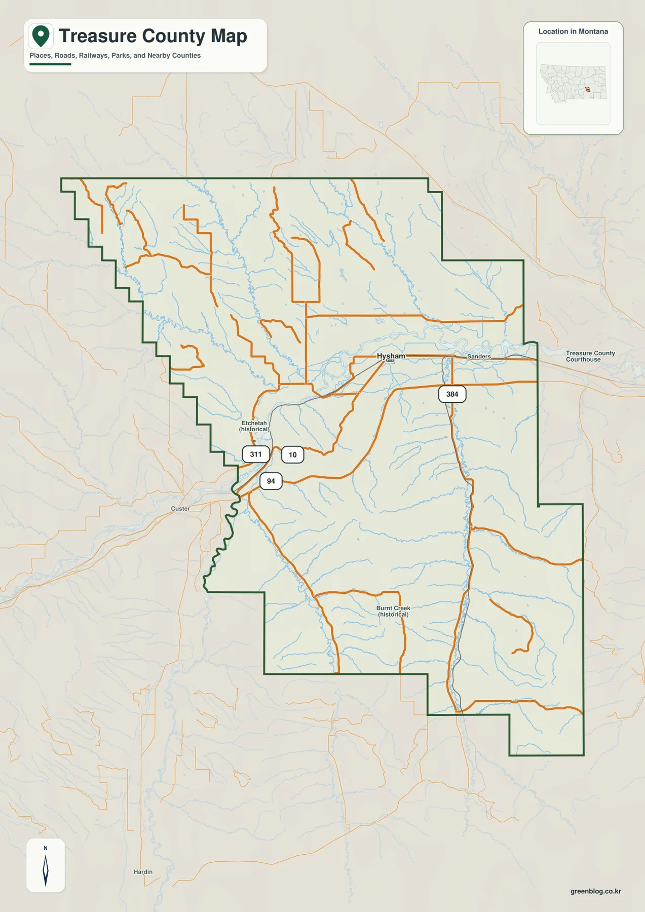
The general county map places Hysham near the Yellowstone River and shows the main road network around the central valley. Interstate 94 enters from the west and follows the broad river corridor, while other numbered roads, including routes marked 10, 311, and 384 on the map, connect the central area with locations farther north and south. The concentration of roads around Hysham makes it a useful reference point for orienting the rest of the county.
Sanders is labeled east of Hysham, and Custer appears just outside the western side of the county. The map also includes historical place labels such as Etchetah and Burnt Creek. Those labels are useful for geographic reference, but a name on the map should not be interpreted as proof that every place has the same present-day municipal or administrative status. For current addresses, services, or jurisdictional questions, consult the county or other responsible public agency.
The northern part of Treasure County spreads broadly east and west, while the southern boundary extends farther down and breaks into several stepped sections. That shape matters when estimating travel. A location that appears close in a straight line may require a longer drive because roads follow valleys and avoid rougher terrain. Use this map to understand direction and relative position, then use a current routing service for driving distance and travel time.
Hysham as the single ranked city on the city map
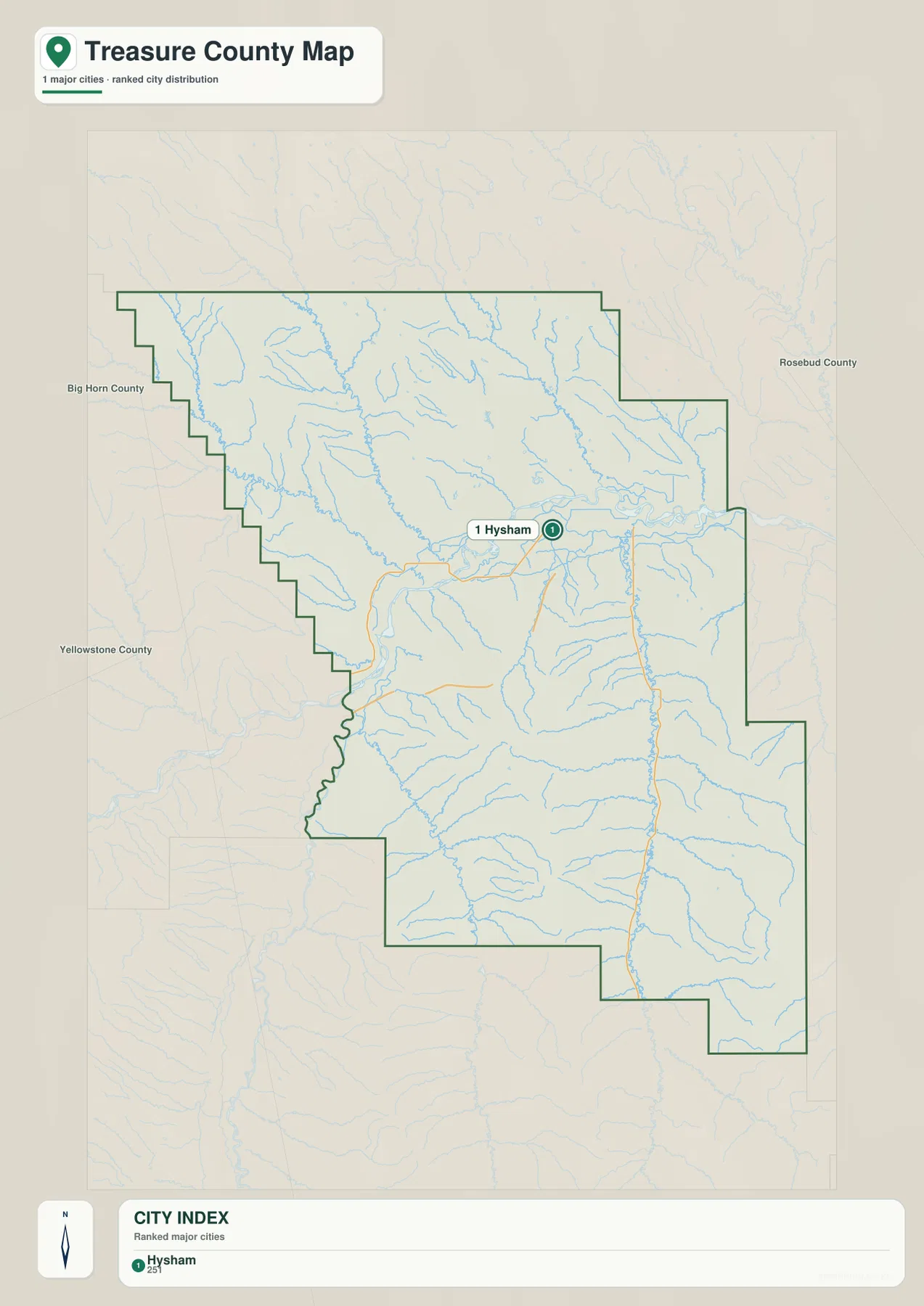
The supplied city distribution map identifies one ranked major city: Hysham. Because there is only one selected city, the map does not draw a connector to a second city and does not display a city-to-city straight-line distance. This differs from county maps where two or more ranked cities can be compared directly. Here, the value of the city map is its simplicity: it shows exactly where the county’s principal town sits within the much larger rural area.
Hysham is not at the geometric center of the county, but it is near the central Yellowstone River valley and the main east-west road corridor. Broad uplands extend north of it, and higher, more dissected country occupies much of the south. When the city map is compared with the elevation map, the town’s setting in a lower valley becomes immediately apparent.
The map is also useful for understanding why a list of several large towns is not appropriate for this county page. The county is predominantly rural, and the official 2025 county wildfire plan identifies Hysham as the one incorporated town and county seat. Unincorporated and historical place names still matter locally, but they should not be presented as if they were equivalent ranked cities.
Yellowstone River, tributaries, canals, and reservoir features
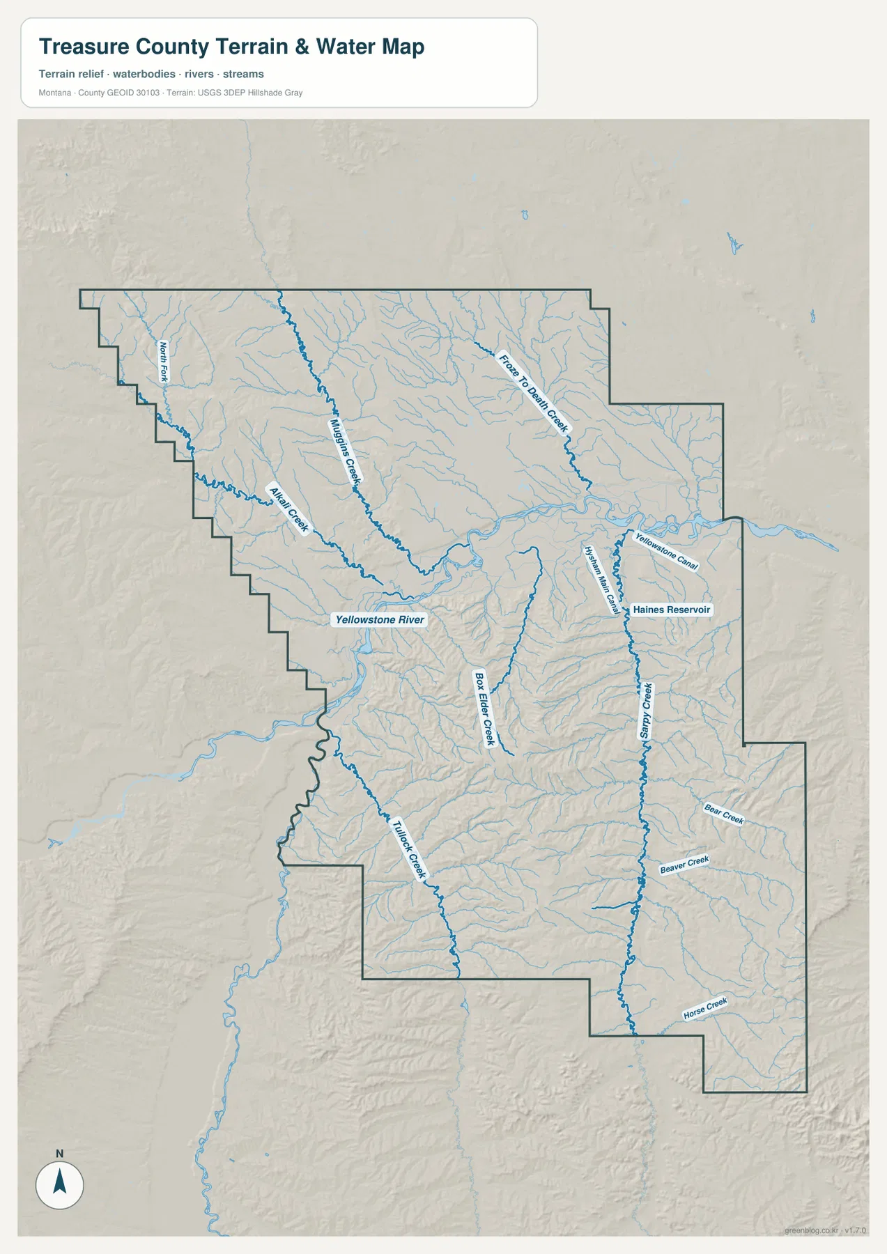
The Yellowstone River is the dominant water feature on the terrain and water map. It enters from the west, curves through the central portion of Treasure County, and continues east. The river occupies a visibly lower corridor than the hills to the north and south, and many smaller streams descend toward it. This pattern gives the county a clear geographic spine even though the political boundary itself is irregular.
Several named tributaries are visible north of the river, including North Fork, Alkali Creek, Mustang Creek, and Froze To Death Creek. South of the Yellowstone, Box Elder Creek and Tullock Creek stand out, while Sarpy Creek forms a long north-south drainage in the eastern half of the county. Beaver Creek, Bear Creek, and Horse Creek join the Sarpy Creek system from the surrounding hills. Following these names on the map is an effective way to see how the upland valleys descend toward the main river.
The eastern-central area also shows the Yellowstone Canal and Haines Reservoir. These features add a human water-management layer to the natural stream network. The map is intended as a geographic reference for relative location and terrain context; it is not a floodplain map, water-right record, parcel survey, or navigation chart. Questions about legal access, water rights, flood risk, or engineering conditions should be checked against the appropriate current agency records.
Elevation map: a low river corridor between higher uplands
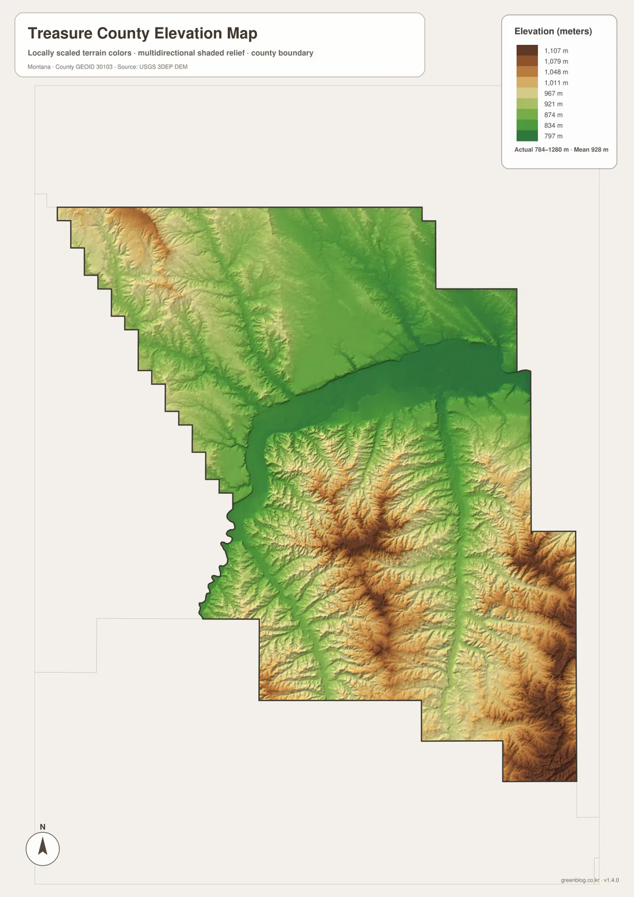
The elevation map makes the county’s terrain contrast especially clear. The legend reports an actual elevation range of about 784 to 1,280 meters, with a mean near 928 meters. Darker green follows the lowest ground around the Yellowstone River, creating a broad east-west band through the middle of the county. Hysham lies near this low corridor rather than in the higher southern country.
South of the river, the land rises and becomes more deeply divided by stream valleys. Brown and darker tan areas mark higher ground across the south-central and southeastern sections, while narrow green valleys trace the drainage routes between ridges. Sarpy Creek and its tributaries cut through this higher terrain. The northwestern edge also contains elevated ground, but the broadest and strongest relief on the map is south of the Yellowstone.
The colors are locally scaled for Treasure County, so they are best used to compare elevations within this map. A similar color on another county map may represent a different absolute height. The surface is also generalized for regional visualization. It should not be treated as survey-grade elevation data for construction, drainage design, property boundaries, or other engineering work; those uses require original elevation datasets and, when necessary, field survey measurements.
Why the Yellowstone valley matters to settlement and transportation
Reading the four map views together shows a strong connection between the lower Yellowstone valley, Hysham, and the main transportation corridor. The river occupies lower ground than most of the southern uplands, and the principal east-west road follows the same general corridor. The official county plan also notes that much of the population is concentrated near the river valley. That does not mean every road or residence sits directly beside the river, but it helps explain the pattern visible on the maps.
The surrounding uplands are equally important to the county’s geography. North of the river, rolling terrain is crossed by numerous small creeks. To the south, ridges and valleys become more pronounced, especially around the Sarpy Creek drainage. When the basic road map is compared with the elevation map, the more limited road pattern in parts of the high country becomes easier to understand without reducing the landscape to a simple north-versus-south description.
Practical ways to use the maps
For a first look at Treasure County, begin with the general map and locate Hysham, the county boundary, and the Yellowstone River. Next, follow Interstate 94 and the other numbered routes to see how the central valley connects with the county edges. This sequence works well for basic orientation because it anchors roads and places to one easily recognized natural feature.
If your interest is physical geography, move from the water map to the elevation map. Trace the Yellowstone River first, then follow tributaries such as Sarpy Creek, Tullock Creek, Box Elder Creek, Mustang Creek, and Froze To Death Creek into the surrounding uplands. The elevation colors show why many of those tributaries occupy narrow valleys and why the central river corridor appears broader and lower.
For classroom, presentation, or print use, the downloaded JPG files provide more resolution than the web preview images. The county map is useful for boundaries and road context, the city map gives a clean view of Hysham’s location, the water map emphasizes river and creek relationships, and the elevation map highlights relief. Keeping these purposes separate makes each map easier to read than a single graphic crowded with every available layer.
A brief county background
Treasure County was created in 1919 from part of Rosebud County, with Hysham established as the county seat. Historical Montana water-resource material records the county’s organization in April 1919, while current county planning documents continue to identify Hysham as the local governmental center. This history fits the map pattern: the town occupies the main river and transportation corridor rather than the more rugged uplands.
Current county planning material describes Treasure County as a predominantly rural landscape shaped by agriculture, ranching, river valleys, and rolling hills. The supplied maps visualize that description without requiring a dense statistical profile. The central Yellowstone corridor forms the most continuous lowland, while broad uplands and creek valleys occupy much of the remaining area. Together, those features give the county a recognizable physical structure despite its relatively small number of major settlements.
Frequently Asked Questions
What is the best place to locate first on the Treasure County map?
Start with Hysham and the Yellowstone River. Hysham is the county seat and sits close to the main river and road corridor, so it provides a useful anchor for the rest of the map. From there, you can follow the river east and west or compare the town with the higher terrain to the south.
Why does the city map not show a straight-line distance between cities?
The supplied city map contains only one ranked major city, Hysham. A connector and straight-line distance require at least two selected cities, so no city-to-city line is appropriate here. For road mileage from Hysham to communities inside or outside the county, use a current routing service rather than estimating from the map.
Can the elevation values be used for surveying or engineering?
No. The map shows an approximate county-wide elevation range of 784 to 1,280 meters and is designed to visualize relative relief. Construction, engineering, drainage, and boundary work require original elevation data and, where appropriate, professional field measurements. The map should be treated as a geographic overview rather than a survey product.
Map File Information
Treasure County map files
- Included Files: Use only the versions confirmed in the article and supplied images
- File Type: Use the confirmed download contents
- Intended Use: Printing, education, presentations, and map-based projects
Related Maps
Sources and references
- Treasure County official website
- 2025 Treasure County Community Wildfire Protection Plan
- U.S. Census Bureau TIGER/Line Shapefiles
- USGS National Hydrography
- USGS 3D Elevation Program
These maps are intended for geographic reference. For legal boundaries, water rights, flood determinations, engineering, surveying, or other decisions that require current authoritative information, consult Treasure County and the responsible state or federal agency.
Green Map creates custom-edited map images using open geographic data sources such as geoBoundaries, Natural Earth, OpenStreetMap, and government open data. These maps are edited visual materials, not raw data files, and are provided for education, documents, presentations, and graphic reference.