Sweet Grass County sits in south-central Montana, where Big Timber occupies a practical crossroads between the Yellowstone River valley and the Boulder River valley. The county stretches from broad rolling country in the north through a central river corridor and far into rugged mountain terrain in the south. The maps on this page show boundaries, roads, settlements, waterways, lakes, and elevation, and the matching high-resolution JPG map files are available for download for printing or personal reference.
Looking at the maps together makes the county easier to understand than a single road map can. Big Timber is positioned close to the meeting of two major rivers, Interstate 90 runs east-west through the Yellowstone corridor, and U.S. 191 heads north from town. Farther south, the land rises sharply and roads become more closely tied to river valleys. That contrast between a lower central corridor and mountainous southern country is one of the defining patterns visible across the set.
Table of Contents
Roads and county boundaries converge on Big Timber
The general county map places Big Timber near the center of the transportation network. Interstate 90 follows the Yellowstone River corridor from west to east, connecting the Big Timber area with Greycliff and the Reed Point direction. U.S. 191 leaves Big Timber and runs north toward the upper part of the county, while Route 298 serves the southwest side and the map also shows Route 371 farther north. McLeod appears southwest of Big Timber along the Boulder River corridor, and Greycliff is shown to the southeast near the Yellowstone valley.
The county outline is distinctive because it is broad across the north but extends south in a long, stepped shape. Labels around the boundary include Park County, Wheatland County, Meagher County, Golden Valley County, Stillwater County, and Carbon County. Those surrounding names are useful orientation points, especially when the map is used to understand trips that cross a county line. The southern extension also signals a major geographic change: the farther the county reaches into the mountains, the less its landscape resembles the open central valley near Big Timber.
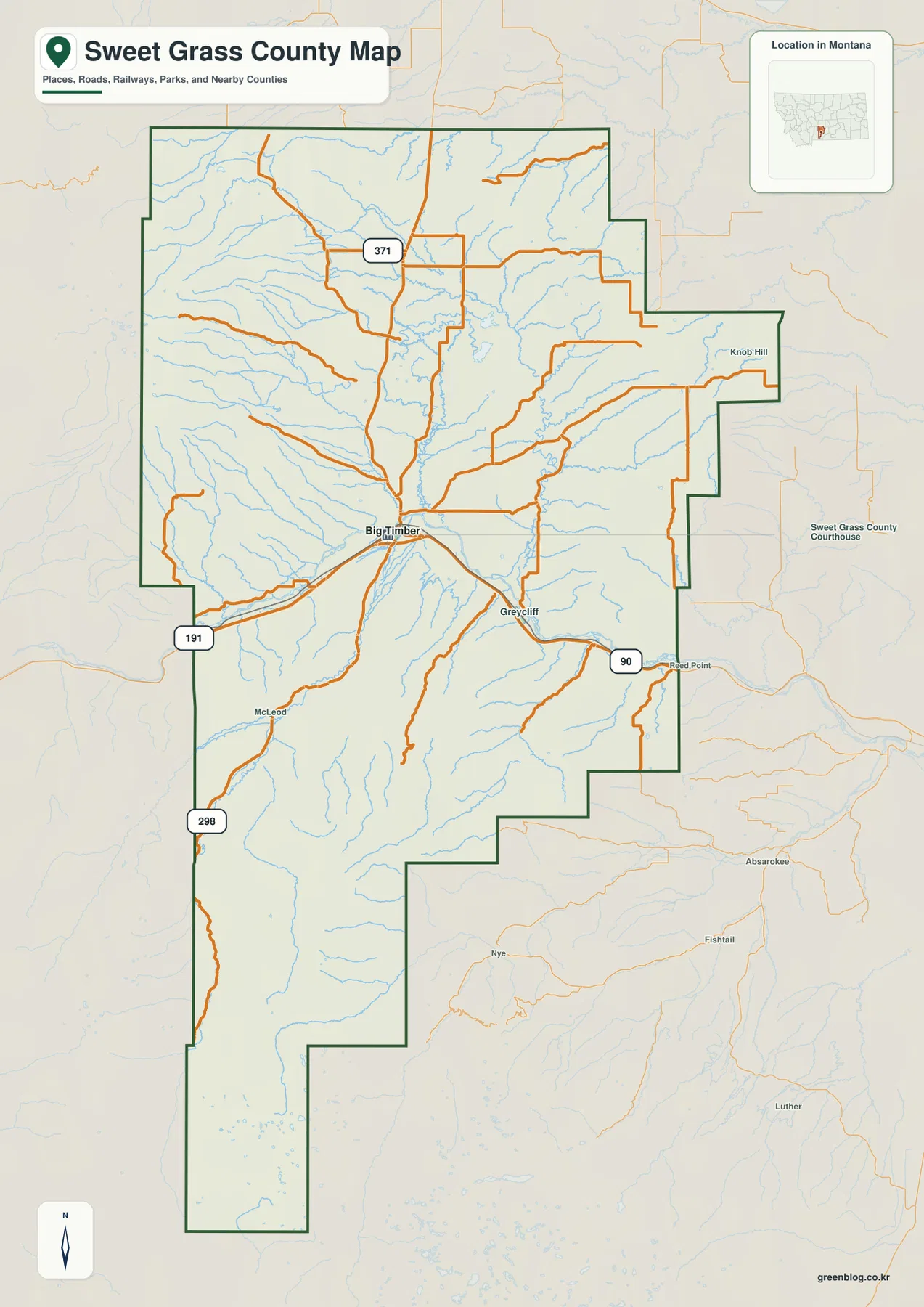
Big Timber is not just the largest label on the map. A Montana Department of Environmental Quality source-water report describes the town as the county seat and places it near the confluence of the Boulder River and Yellowstone River. That setting helps explain why several road corridors meet here. The map therefore works well for understanding both administrative geography and the physical reasons that transportation and settlement concentrate around one part of the county.
The settlement pattern is strongly centered on one town
The city distribution map simplifies the settlement picture by ranking major cities rather than trying to label every small community. In the supplied city index, Big Timber is the only ranked major city. That does not mean the rest of Sweet Grass County is empty. The general map identifies smaller places such as Greycliff and McLeod, while nearby communities outside the boundary provide additional geographic context. The city map is best read as a quick guide to the dominant urban center, not as a complete directory of every populated place.
Big Timber’s position becomes even more meaningful when the road network is considered. Interstate 90 gives the town a direct east-west connection through the Yellowstone valley. U.S. 191 reaches north from town, while routes following the Boulder River open access toward the mountainous south. Because southern Sweet Grass County is more rugged and its valleys are narrower, the road system is less evenly distributed there. For visitors or researchers, this makes Big Timber a logical reference point when measuring where other features sit within the county.
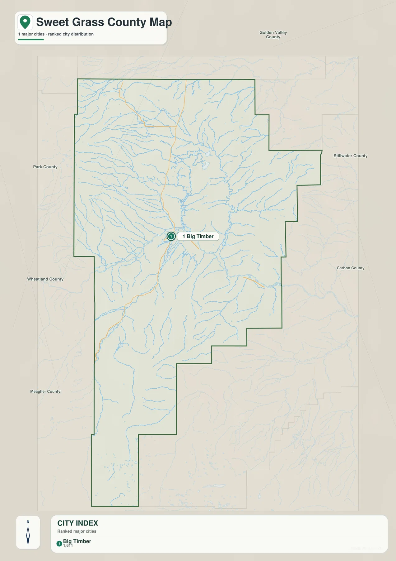
This map should not be treated as a travel-time or turn-by-turn navigation product. Its strength is visual scale: it quickly shows how one main town relates to the large surrounding county. When planning an actual drive, especially into mountain valleys, current road conditions and a navigation service are still necessary. For general geographic understanding, however, the simplified city view makes the county’s sparse settlement pattern immediately clear.
The Yellowstone and Boulder rivers define the central corridor
The terrain and water map reveals a dense network of streams feeding into larger river systems. The Yellowstone River crosses the Big Timber area and continues east, while the Boulder River comes north from the mountains and meets the Yellowstone near town. The U.S. Geological Survey maintains named monitoring locations for both the Boulder River at Big Timber and the Yellowstone River at Big Timber, confirming the importance of these two rivers in the county’s central hydrology.
Northwest of the central valley, the map labels Sweet Grass Creek and Rein Lake. Spring Creek appears in the northeast, and Otter Creek is shown closer to the middle. Upper Glaston Lake and Lower Glaston Lake sit in the north-central part of the county. The southern half becomes more mountainous and includes East Boulder River, West Fork Stillwater River, Kent Lake, Owl Lake, Fish Lake, and Pentad Lake. Seeing these names on shaded relief helps distinguish broad drainage areas from the steeper stream valleys farther south.
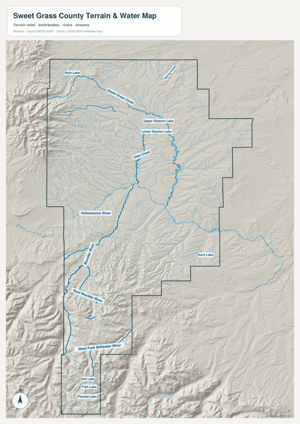
The water map is a geographic reference rather than a flood, parcel, legal-boundary, or navigation map. It can show where streams are located and how they relate to the surrounding terrain, but it should not be used to determine flood exposure, property limits, access rights, or safe water travel. For those decisions, current agency data are required. As an overview, it is especially useful for explaining why roads and settlements tend to occupy lower valleys while the stream network fans through the high country.
Elevation rises sharply toward the southern high country
The elevation map makes the county’s strongest topographic contrast easy to see. Big Timber and the Yellowstone corridor appear in lower green tones, while the western edge and the long southern extension shift toward yellow, tan, and brown. The supplied elevation graphic reports an actual range of about 1,143 to 3,430 meters and a mean of about 1,713 meters. That is a large difference within one county and helps explain why the central valley and the southern mountains support very different road and settlement patterns.
Sweet Grass County’s own growth-policy material discusses the Crazy Mountains to the northwest and Beartooth-related geology in the southern part of the county. Those descriptions match the broad relief pattern visible here: pronounced mountain ridges appear along the western and southern portions, while lower ground extends through the central river corridor. The color transitions are therefore more than decorative. They give a quick visual explanation for why several streams descend from higher country toward the Yellowstone system and why major transportation stays closer to lower terrain.
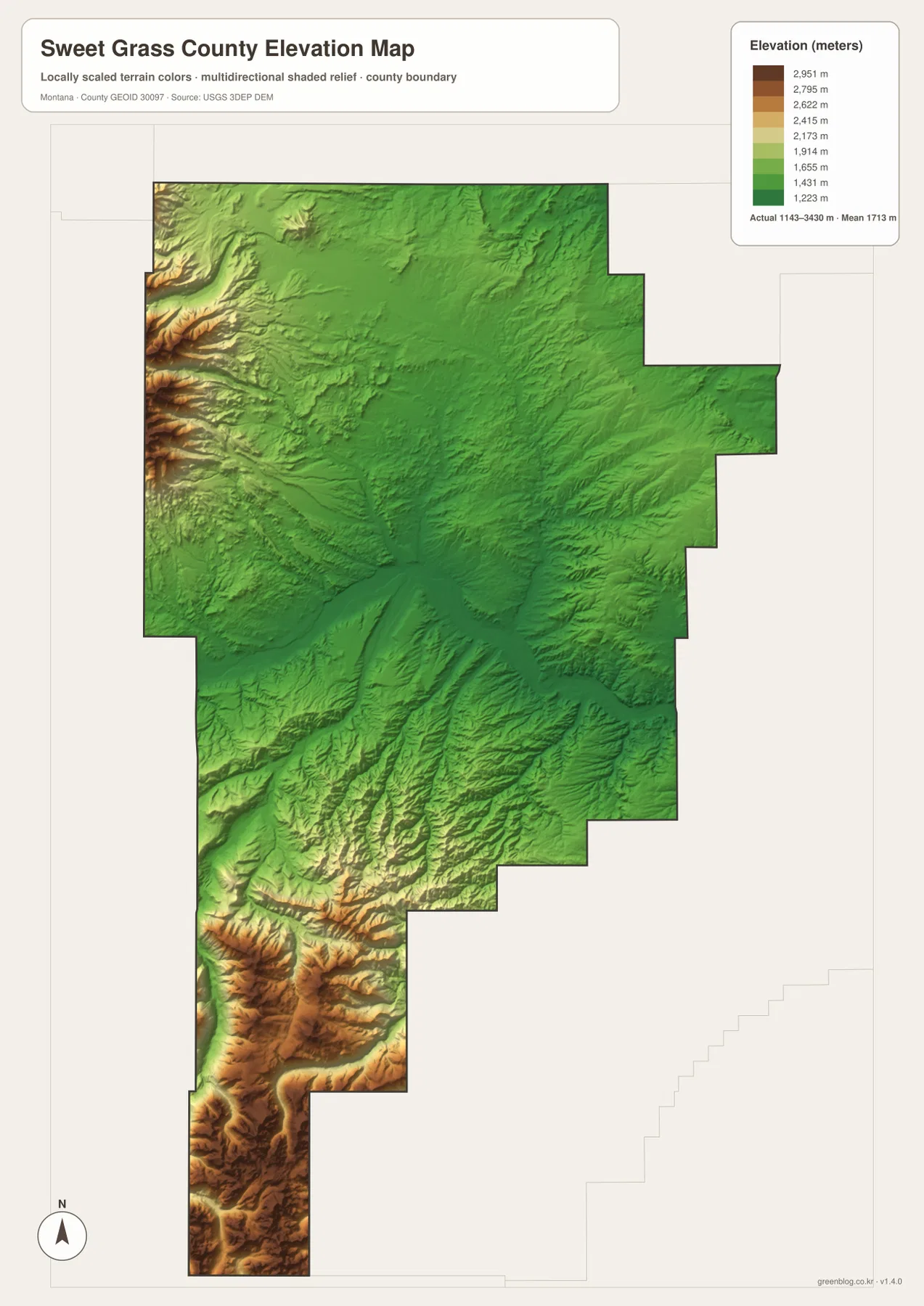
This elevation surface is generalized for regional viewing. It is not survey-grade elevation data and should not replace engineering measurements, site surveys, or detailed trail information. It is well suited to broad comparison, though. A reader can identify the low central valley, the rising mountain fronts, and the way streams occupy lower channels through rugged ground without needing to interpret a dense contour map.
Choosing the map that fits the question
For county orientation, the general map is the best starting point because it combines the boundary, named places, roads, railways, and nearby counties. It is the most useful choice when someone needs to locate Big Timber, Greycliff, McLeod, or major routes on one page. The city distribution map is intentionally simpler. It is better when the main question is where the county’s dominant urban center lies and how far that center appears from the edges of the county.
The terrain and water map becomes more useful when rivers, lakes, and valleys matter. It clarifies the relationship between Yellowstone River, Boulder River, Sweet Grass Creek, and the smaller streams that descend from the mountains. The elevation map answers a different question by showing where the land rises most sharply. Using the two together can explain why a stream follows a particular valley or why a road corridor stays in lower terrain rather than crossing the highest ridges.
The four files complement one another. A practical sequence is to find a place or highway on the general map, compare the settlement pattern on the city view, trace nearby water on the terrain map, and then check the elevation surface. That approach works for classroom projects, personal trip research, regional presentations, or printed reference sheets without requiring specialized GIS software.
Details that are easy to miss on a first look
Sweet Grass County is not a uniformly shaped or uniformly settled place. Its northern portion is broad, while the boundary narrows and steps south into much higher terrain. If only the road map is viewed, the county can seem to revolve almost entirely around Big Timber. The water and elevation maps add the missing context by showing the extensive headwater country and mountain valleys that occupy much of the southern area.
Some labels near the edge of the general map fall outside the Sweet Grass County boundary. Places such as Reed Point, Absarokee, and Nye can appear in the surrounding background because they help orient the viewer, not because every label belongs to the county itself. The same principle applies to neighboring county names. Reading the dark county outline first prevents confusion when using the map for local study.
The downloadable JPG files are larger than the on-page WebP previews and are better suited to printing or close inspection. Even so, their purpose is geographic overview. Property ownership, legal boundaries, flood zones, active road closures, and site-specific elevations require current authoritative datasets. These maps work best as an accessible first layer for understanding how Big Timber, rivers, roads, and mountain terrain fit together across Sweet Grass County.
Frequently Asked Questions
Where is Big Timber within Sweet Grass County?
Big Timber lies slightly north of the county’s midpoint, close to the Yellowstone River and the Boulder River confluence. Interstate 90 passes through the area from west to east, and U.S. 191 runs north from town. The supplied city distribution map identifies Big Timber as the county’s main ranked city.
Which map best shows the southern mountain terrain?
The elevation map gives the clearest overview because its colors show the strong rise from the central valley into the southern high country. For a closer look at mountain valleys and streams, pair it with the terrain and water map, which labels East Boulder River, West Fork Stillwater River, and several lakes in the southern part of the county.
What is included in the downloadable archive?
The ZIP archive contains four high-resolution JPG files matching the maps shown on the page: the general county map, city distribution map, terrain and water map, and elevation map. They can be used for printing, personal reference, classroom work, or other non-specialized map needs.
Map File Information
The download archive contains the same four Sweet Grass County maps shown on this page as original high-resolution JPG files.
- Printable Size: 2572 × 3638 px each
- File Type: JPG
Related Maps
Sources and references
- Sweet Grass County Growth Policy – county history, geology, and local geographic context
- Montana DEQ Big Timber Source Water Report – Big Timber location and the Boulder–Yellowstone confluence area
- USGS Yellowstone River at Big Timber, MT – river monitoring location in Sweet Grass County
- USGS Boulder River at Big Timber, MT – Boulder River monitoring location and drainage information
- U.S. Census Bureau TIGER/Line Shapefiles – boundary and transportation reference data
- USGS 3D Elevation Program – elevation-data reference
Green Map creates custom-edited map images using open geographic data sources such as geoBoundaries, Natural Earth, OpenStreetMap, and government open data. These maps are edited visual materials, not raw data files, and are provided for education, documents, presentations, and graphic reference.