Hill County spans a broad part of north-central Montana, with Havre as the clearest urban and road reference and Hingham farther west along the U.S. 2 corridor. Much of the north and west is open, relatively low country, while the southeastern corner rises sharply around the Bear Paw uplands near Rocky Boy’s Agency and St. Pierre. The terrain-and-water map adds another layer: Milk River and Fresno Reservoir organize the north, Sage Creek marks the west-central interior, and Big Sandy Creek with Beaver Creek helps define the southeast. High-resolution JPG versions of the maps are available together in the download ZIP below.
The City of Havre identifies Havre as the Hill County seat, and USDA NRCS material describes Havre and Hingham among the county’s incorporated communities. That makes the map easy to approach: begin with Havre, follow U.S. 2 west through Hingham and Inverness, then compare the lower northern water corridors with the much higher Bear Paw country in the southeast.
Table of Contents
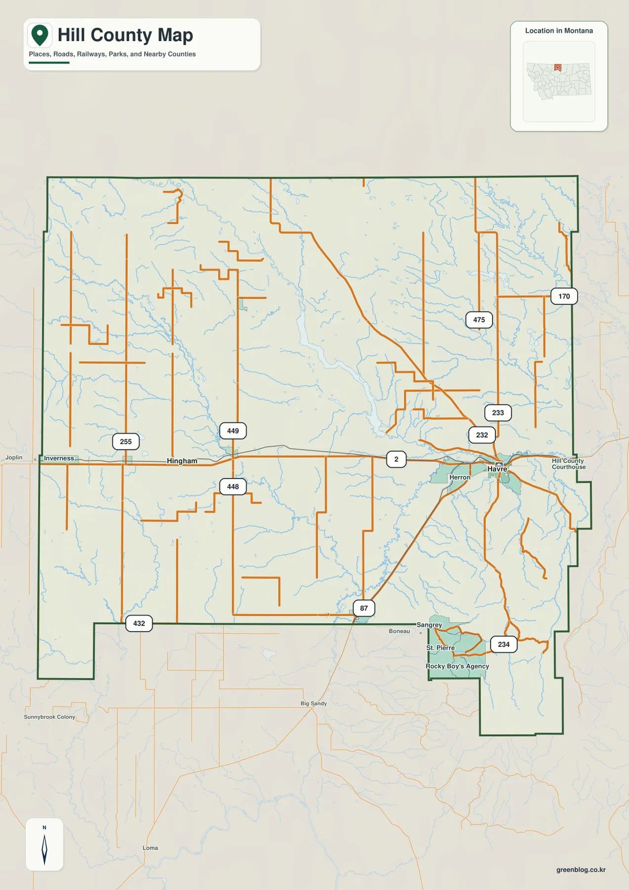
Havre anchors the main east-west and southbound road corridors
On the general county map, Havre sits in the east-central part of Hill County. U.S. 2 runs west through Hingham and Inverness and continues east toward Blaine County. U.S. 87 leaves the Havre area toward the southwest, providing the strongest road reference for the southern interior.
Routes 232 and 233 are labeled around Havre, while routes 475 and 170 extend through the north and northeast. Around Hingham, routes 449 and 448 provide additional rural references, and Route 255 appears farther west near the Inverness side. Route 432 reaches into the county’s southwestern projection.
Route 234 is prominent in the southeast around Rocky Boy’s Agency, St. Pierre, and Sangrey. The road network is noticeably denser around Havre and the southeastern communities than across the broad northern and western interior. Because this is a static map, current construction, winter closures, and unpaved-road conditions should be checked separately.
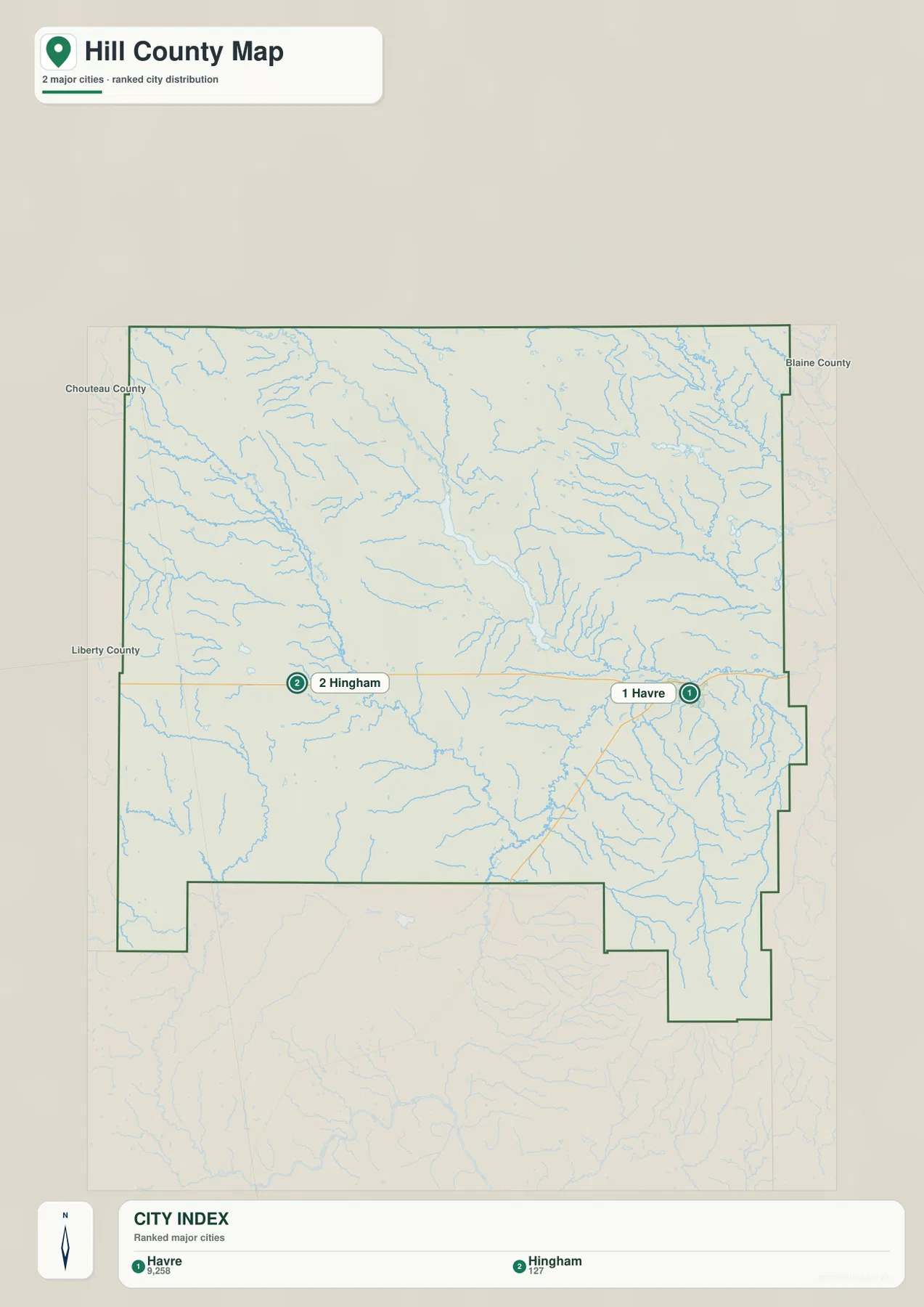
Havre and Hingham are the two ranked cities
The city map ranks two places: Havre and Hingham. Its printed index lists Havre at 9,258 and Hingham at 127. These are values embedded in the supplied map and should not be treated as guaranteed current population estimates. Current demographic totals should be checked through recent U.S. Census Bureau data.
Havre lies in the east-central part of the county, while Hingham sits farther west along the same broad U.S. 2 corridor. The surrounding labels for Liberty, Chouteau, and Blaine counties help place Hill County within northern Montana.
No connector line or mileage label is printed between Havre and Hingham. The spacing on the map should therefore be treated only as a location reference, not as straight-line distance or road mileage. Actual travel should be checked on the general map and with current navigation information.
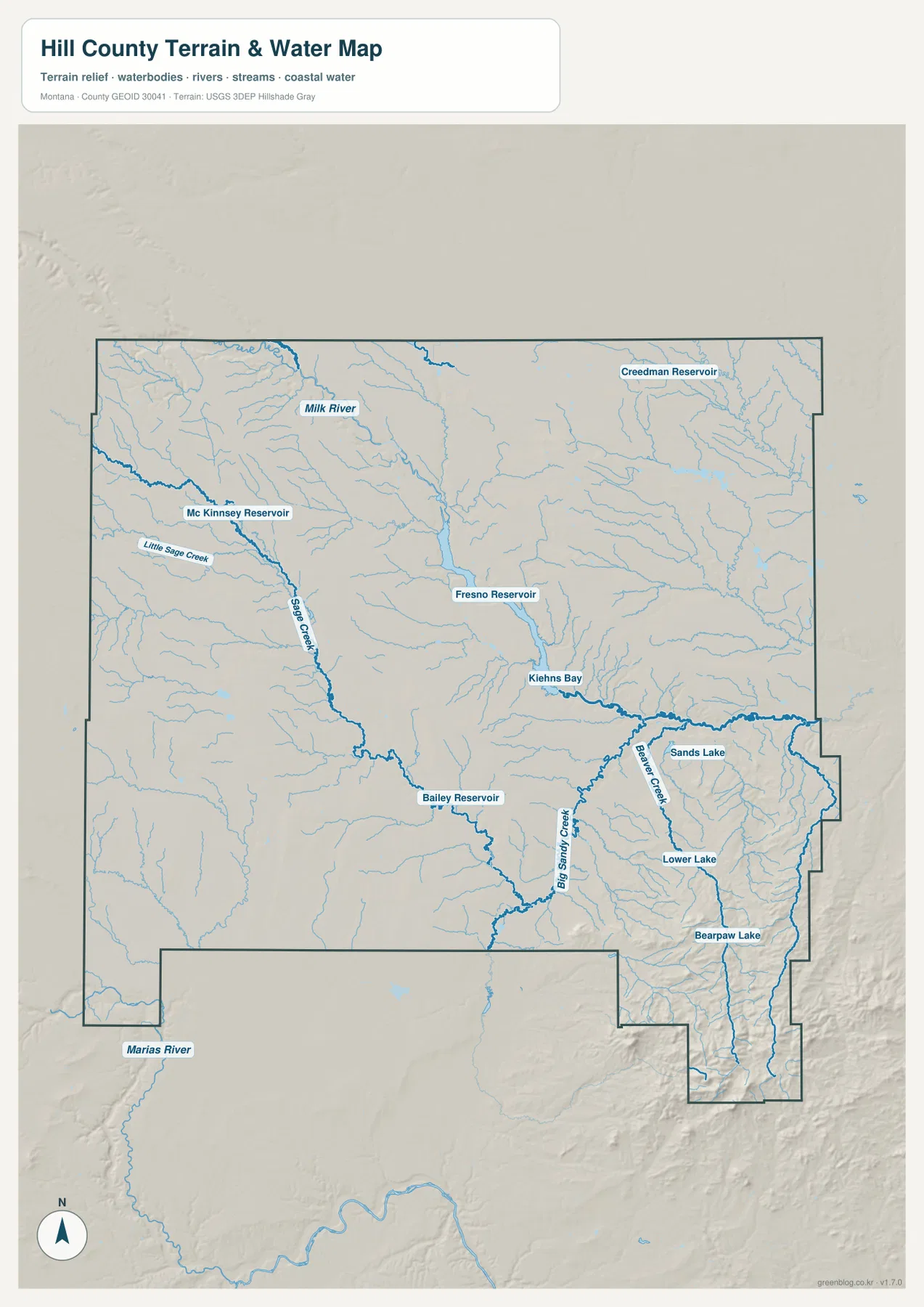
Milk River and Fresno Reservoir organize the northern interior
The terrain-and-water map makes Milk River one of the strongest features in the northern part of Hill County. The river crosses the upper interior, and Fresno Reservoir forms a long water body near the center-north. USDA NRCS material for Hill County also identifies Fresno Dam on the Milk River as an important local water feature.
Kiehns Bay appears on the lower side of Fresno Reservoir, while Creedman Reservoir lies farther northeast. Mc Kinnsey Reservoir is positioned in the west near Sage Creek. In a county with large areas of sparse settlement, these water bodies provide useful references for locating otherwise similar-looking rural terrain.
The terrain-and-water map is designed for geographic reference. It does not establish flood zones, water depth, parcel boundaries, water rights, navigation conditions, or safe crossing locations. Current access and water conditions should be checked through the appropriate agencies.
Sage Creek and Big Sandy Creek divide the southern interior
Sage Creek provides a long drainage reference through the west-central part of the county. Little Sage Creek joins from the west, and numerous smaller tributaries enter as the channel continues south. This creek helps organize a large area away from the main U.S. 2 settlement corridor.
Farther southeast, Big Sandy Creek becomes one of the strongest named drainages on the map. Beaver Creek joins from the east, and Sands Lake, Lower Lake, and Bearpaw Lake sit within the more rugged terrain nearby. Bailey Reservoir provides another reference farther west between the Sage Creek and Big Sandy Creek areas.
Marias River is labeled outside the southwestern county boundary and is useful only as a nearby regional landmark. The southeastern lakes and creeks sit much closer to high relief, which becomes especially clear when the same area is viewed on the elevation map.
Elevation rises from about 747 meters to 2,091 meters
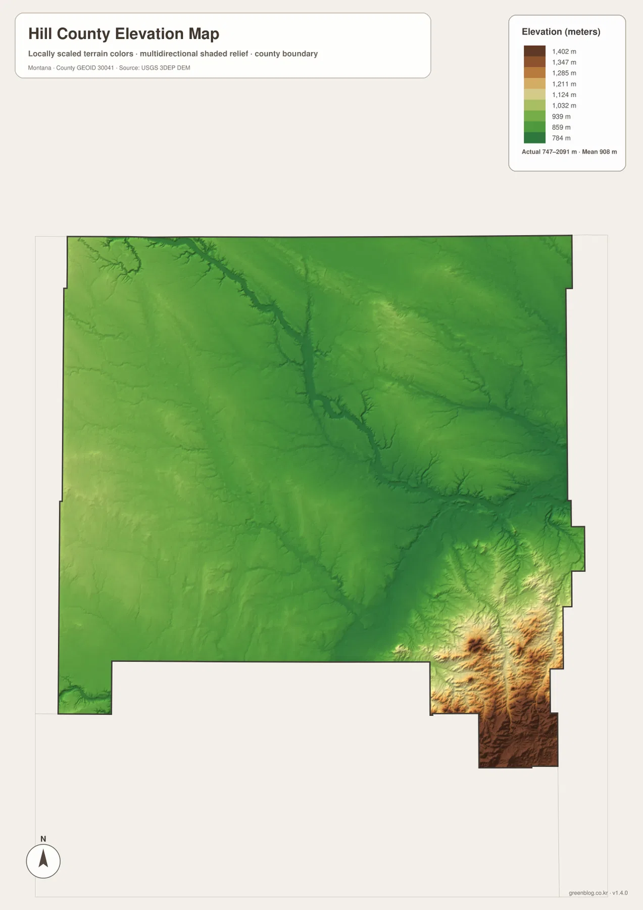
The elevation map reports an actual Hill County range of about 747 to 2,091 meters, with a mean elevation near 908 meters. Most of the north and west appears in green, indicating broad lower terrain. Milk River and the Fresno Reservoir corridor also remain within this lower part of the county.
The strongest elevation increase occurs in the southeast around the Bear Paw uplands near Rocky Boy’s Agency and St. Pierre. Ridges and narrow valleys are packed much more closely together there, and the colors change quickly through yellow and brown. Big Sandy Creek and Beaver Creek occupy lower routes within this high country.
The central interior is somewhat higher than the northern plain but does not reach the same relief as the southeast. Sage Creek and many tributaries remain visible as lower drainage corridors. The elevation map is intended for county-wide comparison only and should not be used as survey-grade or engineering-grade data for a specific property.
Use Havre to separate the western plains from the Bear Paw country
A practical way to read Hill County is to begin at Havre and divide the map into two broad directions. Westward, U.S. 2 links Hingham and Inverness across open lower country. North of that corridor, Milk River and Fresno Reservoir provide the strongest water references. South and southeast of Havre, the road network turns toward Rocky Boy’s Agency and the higher Bear Paw terrain.
Sage Creek and Mc Kinnsey Reservoir help with the west-central area, while Fresno Reservoir and Bailey Reservoir organize the middle. Big Sandy Creek, Beaver Creek, Sands Lake, and Bearpaw Lake are useful for the southeast. The elevation map ties those features together by showing how sharply the southeastern terrain rises above the rest of the county.
The WebP images embedded in the article are convenient for quick browsing. The high-resolution JPG files in the ZIP are better for printing or enlarging small road, creek, and reservoir labels. Because these are static reference maps, current road conditions, reservoir levels, and land-access restrictions should be checked through current official sources.
Frequently Asked Questions
Does the city map show the distance between Havre and Hingham?
No. The city map ranks and locates Havre and Hingham but does not print a connector line, straight-line distance, or road mileage between them. Use the general county map and current navigation information for an actual trip.
Where is the highest terrain in Hill County?
The highest terrain is concentrated in the southeastern Bear Paw uplands near Rocky Boy’s Agency and St. Pierre. Most of the northern and western county is much lower and gentler.
Can the 747–2,091 meter elevation range be used for a property or engineering project?
No. The range is a county-wide reference for comparing the low northern plains with the higher Bear Paw terrain. Precise site elevations should come from an authoritative source such as the USGS 3D Elevation Program and, when necessary, a professional survey.
Map File Information
Download the Hill County county, city, terrain-and-water, and elevation maps as high-resolution A3 JPG files.
- Included Files: county map, city map, terrain and water map, elevation map
- File Type: ZIP containing 4 JPG files
Related Maps
Sources and References
County government information is available from the official Hill County website. The City of Havre website identifies Havre as the Hill County seat, and the USDA NRCS Hill County Long Range Plan provides local context on communities, the Milk River, and Fresno Dam.
Boundary and road-reference data can be checked through U.S. Census Bureau TIGER/Line Shapefiles. Hydrographic data are available from USGS National Hydrography, and elevation data through the USGS 3D Elevation Program.
Green Map creates custom-edited map images using open geographic data sources such as geoBoundaries, Natural Earth, OpenStreetMap, and government open data. These maps are edited visual materials, not raw data files, and are provided for education, documents, presentations, and graphic reference.