Cuming County lies in northeastern Nebraska, where West Point anchors a broad Elkhorn River valley surrounded by rolling agricultural uplands. Wisner and Beemer sit northwest of the county seat along the same river-and-highway corridor, while Bancroft is farther northeast. The terrain rises most strongly toward the west and southwest and drops into the Elkhorn valley and lower northeastern drainage country. High-resolution map files are available for download in the section below.
This page explains the county roads and settlements, the straight-line city connections from West Point, the Elkhorn River and its tributaries, and an elevation range of about 388 to 516 meters. The original high-resolution JPG versions of the supplied maps can also be downloaded together in a ZIP for printing, classroom use, or personal reference.
Table of Contents
West Point sits at the center of Cuming County’s Elkhorn Valley history
West Point is the county seat and the easiest place to begin reading the map. Cuming County’s official history says the Nebraska Settlement Association selected the townsite in 1857. It was first called New Philadelphia, but the name soon changed to West Point because it was the westernmost established settlement in the Elkhorn River Valley at the time.
The territorial legislature first defined Cuming County’s boundaries in 1855 and revised them in 1857. History Nebraska records that county officers were elected at West Point on October 12, 1858, and West Point was chosen as the county seat in the same election. On the modern map, the town remains a natural hub where roads converge beside the Elkhorn corridor.
The county government’s town history highlights four principal communities: West Point, Wisner, Beemer, and Bancroft. West Point, Beemer, and Wisner follow the Elkhorn valley toward the northwest, while Bancroft sits in a separate northeastern drainage area. That split is one of the simplest ways to understand the county’s settlement pattern.
U.S. 275 follows the Elkhorn through Wisner, Beemer, and West Point
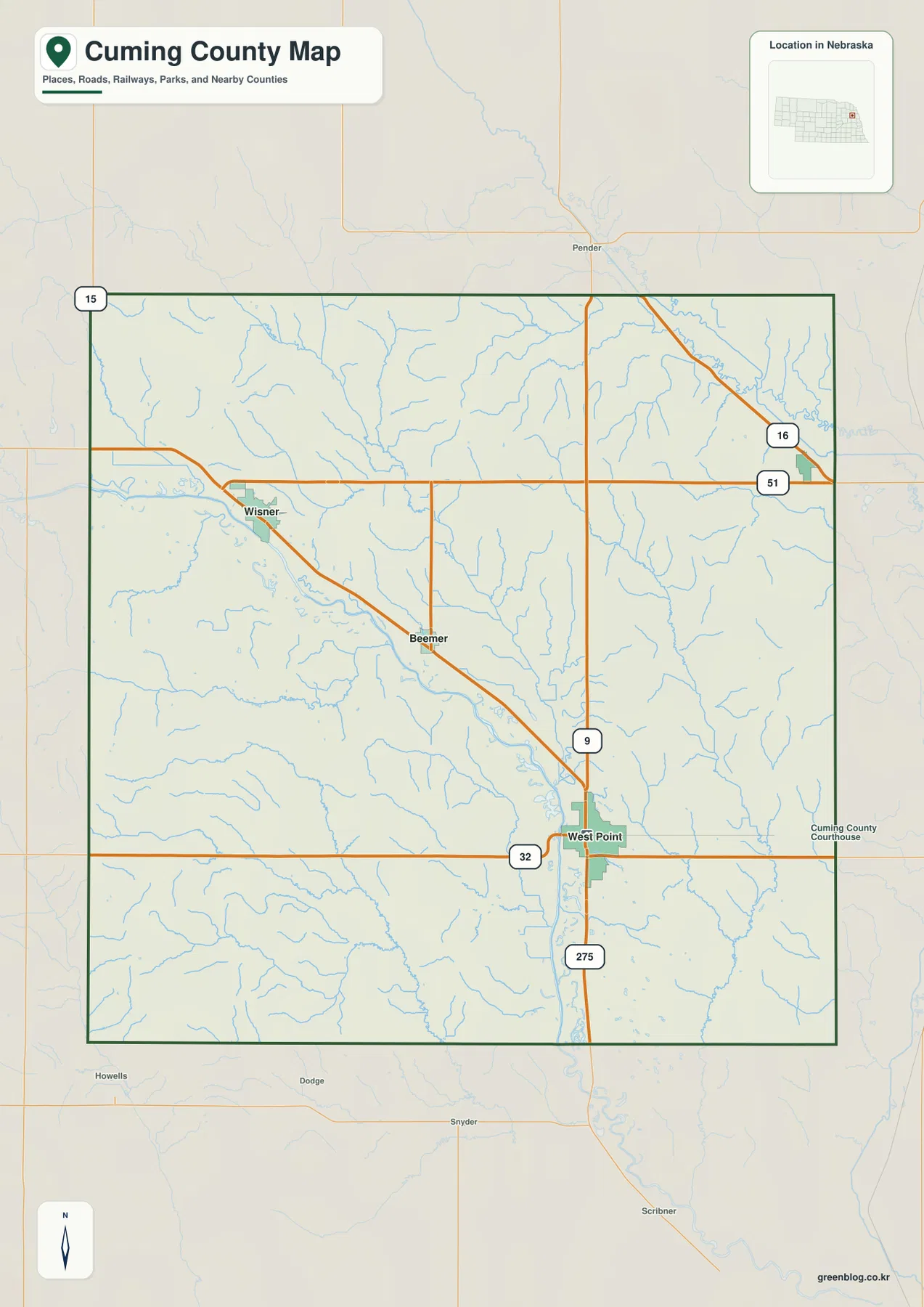
U.S. 275 is the strongest transportation feature on the general map. It enters from the northwest near Wisner, continues through Beemer, and reaches West Point before running south toward Scribner in neighboring Dodge County. A railroad follows much the same valley, reinforcing the close relationship between the Elkhorn, transportation, and town locations.
At West Point, Route 32 provides an east-west reference and Route 9 continues north. Route 51 crosses the upper part of the county toward Bancroft, where Route 16 is also visible. Route 15 appears near the northwestern edge and helps orient the Wayne County side.
The Elkhorn valley supports long, relatively direct transportation lines, while the western and northeastern uplands contain many short creek valleys that break up the local road grid. The map is useful for county-wide orientation, but current construction, closures, surface conditions, and travel times should be checked with live Nebraska transportation information.
West Point is 8 direct miles from Beemer, 14 from Bancroft, and 15 from Wisner
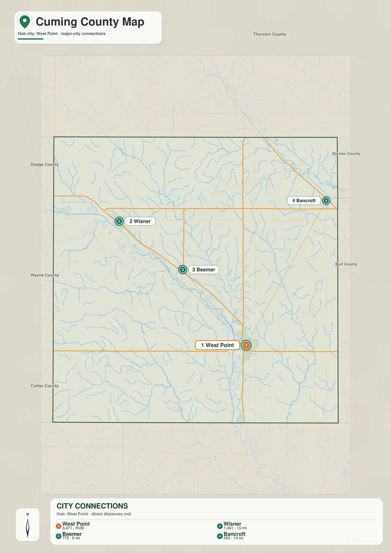
The city-connection map uses West Point as the hub. It shows approximately 8 straight-line miles to Beemer, 14 miles to Bancroft, and 15 miles to Wisner. These are direct point-to-point measurements rather than road mileage, so actual driving distances depend on the route and exact starting and ending locations.
Beemer and Wisner lie northwest of West Point near the Elkhorn River and U.S. 275. Bancroft sits to the northeast, away from the main Elkhorn transportation corridor. The three lines therefore show both distance and direction, making the map useful for quickly distinguishing the river towns from Bancroft’s separate location.
The values printed on the supplied city map are 3,471 for West Point, 1,461 for Wisner, 775 for Beemer, and 593 for Bancroft. They are part of the supplied ranked-city graphic rather than a continuously updated population table. Current demographic figures should be checked with the U.S. Census Bureau or another authoritative source when needed.
Elkhorn River receives a dense network of creeks from both sides
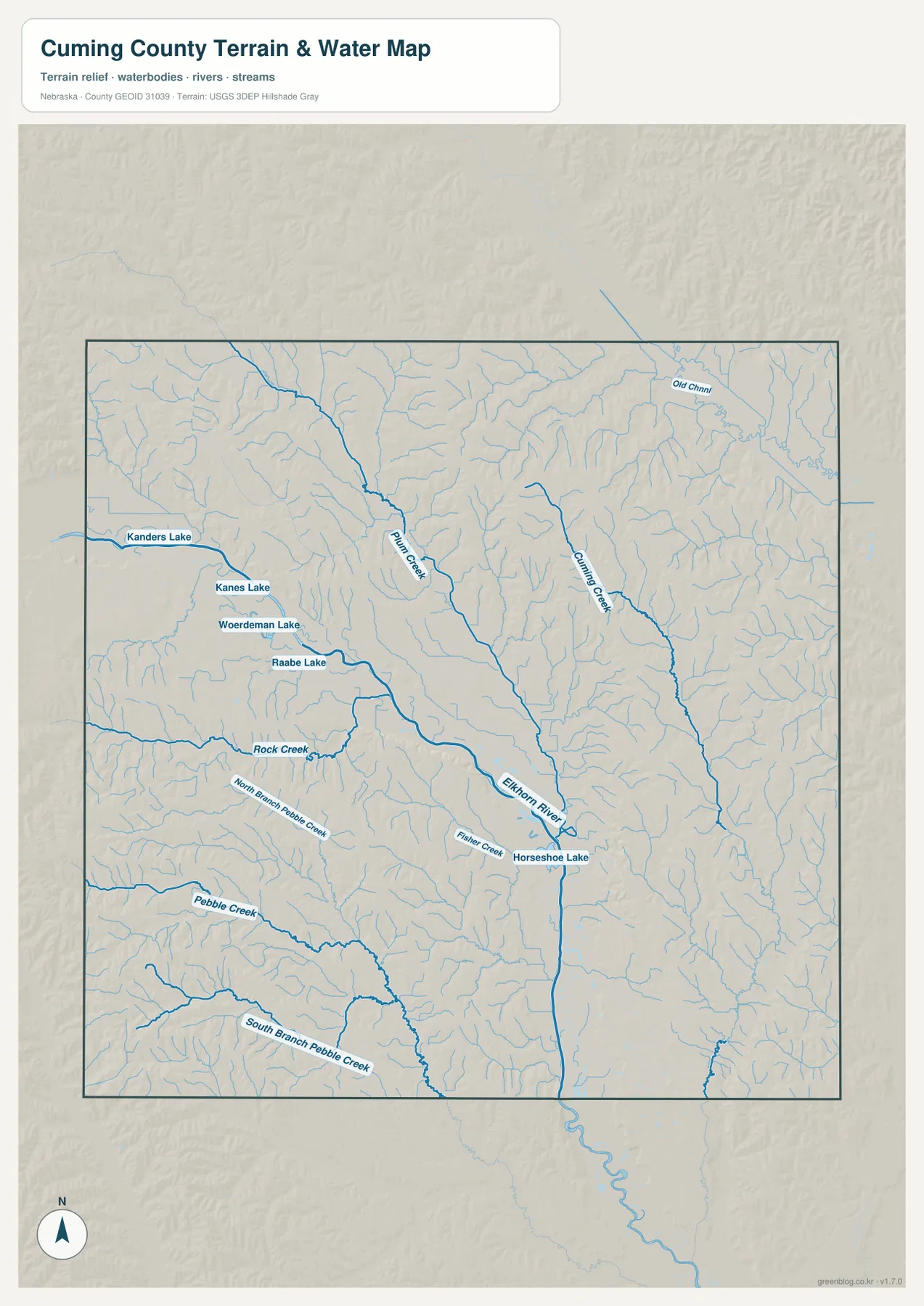
The Elkhorn River is the defining watercourse. It crosses the county from the Wisner area through Beemer toward West Point and then leaves the county to the south. Its valley is broad enough to stand out on both the terrain and elevation maps, and the U.S. 275 corridor follows the same general route.
Plum Creek descends southeastward from the north-central side, while Cuming Creek cuts a parallel drainage farther east. Both receive numerous short tributaries from the surrounding uplands before approaching the lower Elkhorn country. These branching channels explain why the northern half looks much more dissected than a simple road map might suggest.
Rock Creek occupies the west, with North Branch Pebble Creek, Pebble Creek, and South Branch Pebble Creek extending across the southwestern interior. Fisher Creek lies closer to West Point. Small standing-water features include Kanders Lake, Kanes Lake, Woerdeman Lake, Raabe Lake, and Horseshoe Lake.
This map is intended for geographic reference. It does not define flood zones, legal water rights, parcel boundaries, channel depth, navigability, or public access. Those questions require current information from USGS and the appropriate local or state agencies.
The Elkhorn valley sits well below the western and southwestern uplands
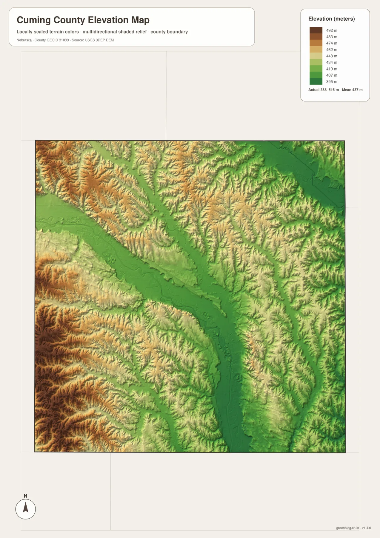
The elevation map reports an actual county-wide range of approximately 388 to 516 meters, with a mean near 437 meters. The darkest green terrain follows the Elkhorn River from northwest to south. Lower ground also spreads across the northeastern corner, while most tributary valleys appear as green cuts through higher surrounding terrain.
The highest brown terrain is concentrated in the west and southwest. Rock Creek and the Pebble Creek branches divide these uplands into repeated ridges and valleys. The total relief is about 128 meters, enough to make the county look surprisingly textured even though it remains part of Nebraska’s agricultural plains.
Plum Creek and Cuming Creek create long lower routes through the northern and eastern uplands. Their green valleys feed toward the Elkhorn corridor, and the relationship becomes especially clear when the water and elevation maps are viewed together. West Point, Beemer, and Wisner all sit close to the county’s major lowland.
The elevation colors are scaled locally for Cuming County and should be used to compare places within this map. Similar shades on another county map may represent different absolute elevations. The generalized surface is not survey-grade information for engineering, construction, drainage design, or property work.
West Point developed from an Elkhorn settlement into a railroad center
Cuming County’s official history says the Nebraska Settlement Association selected the West Point townsite along the Elkhorn in 1857. A sawmill and other businesses followed, and the river valley attracted additional settlers during the early 1860s. The county’s account says newcomers described the productive valley as the “Garden of the West.”
History Nebraska records that the Fremont, Elkhorn and Missouri Valley Railroad reached West Point on November 25, 1870. The county’s town histories show that rail development also shaped Wisner and Beemer. On today’s map, the railroad and U.S. 275 still follow the Elkhorn valley through those same communities.
Wisner, Beemer, and Bancroft each grew around a different local setting
Wisner was platted in 1871 in anticipation of railroad construction and was named for Samuel P. Wisner, a vice president of the Sioux City & Pacific Railway. Beemer developed near Rock Creek, where a mill operated using water power, and the town later grew around the railroad route.
Bancroft followed a different northeastern story. Cuming County’s town history says land was provided for the Sioux City & Nebraska Railway and a townsite was platted in 1880. Its position away from the Elkhorn corridor is easy to see on the city map, where Bancroft sits northeast of West Point rather than along the Wisner-Beemer line.
Use West Point and the Elkhorn River as two simple map anchors
For basic orientation, start at West Point and follow U.S. 275 northwest through Beemer to Wisner. Then shift northeast along Route 51 toward Bancroft. The city-connection view simplifies the same arrangement with three direct-distance lines from West Point.
For physical geography, begin with the Elkhorn River and trace Plum and Cuming creeks into the north before moving west to Rock Creek and the Pebble Creek branches. The elevation map adds the vertical context by showing the Elkhorn valley in green and the western uplands in tan and brown.
For printing or classroom display, the downloadable high-resolution JPG files preserve more road labels and creek detail than the web previews. The county map emphasizes roads and settlements, the city map shows West Point-centered direct distances, the water map identifies the Elkhorn tributaries, and the elevation map highlights the contrast between the river valley and higher western ground.
Frequently Asked Questions
Are the distances from West Point to Beemer, Bancroft, and Wisner driving distances?
No. The city map shows straight-line distances of about 8 miles to Beemer, 14 miles to Bancroft, and 15 miles to Wisner. Actual driving mileage depends on the roads used and the exact starting and ending points.
Where is the lowest terrain in Cuming County?
The Elkhorn River valley through the center of the county contains the lowest broad terrain. The county-wide elevation range is about 388 to 516 meters, with higher ground becoming more common toward the west and southwest.
Can the water map be used for flood or property decisions?
No. It is a geographic reference showing the Elkhorn River, Plum Creek, Cuming Creek, Rock Creek, Pebble Creek, and several small lakes. Flood risk, water rights, parcel boundaries, channel conditions, and access questions require current authoritative records.
Map File Information
The ZIP contains the original high-resolution JPG files for the Cuming County boundary and road map, city-connection map, terrain and water map, and elevation map.
- Included Files: Use only the versions confirmed in the article and supplied images
- File Type: Use the confirmed download contents
- Intended Use: Printing, education, presentations, and map-based projects
Related Maps
Sources and references
- Cuming County – History of Cuming County
- Cuming County – Cuming County Towns
- History Nebraska – Cuming County Historical Note
- U.S. Census Bureau TIGER/Line Shapefiles
- USGS National Hydrography
- USGS 3D Elevation Program
These maps are intended for geographic reference. For legal boundaries, land ownership, flood determinations, water rights, road conditions, construction, surveying, or other decisions requiring current authoritative information, consult Cuming County and the responsible state or federal agency.
Green Map creates custom-edited map images using open geographic data sources such as geoBoundaries, Natural Earth, OpenStreetMap, and government open data. These maps are edited visual materials, not raw data files, and are provided for education, documents, presentations, and graphic reference.