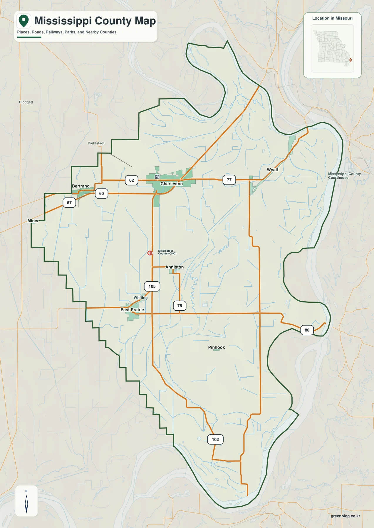
Mississippi County sits in the northeastern part of Missouri’s Bootheel, and its outline immediately shows how strongly the Mississippi River shapes the county. The eastern and northern edges follow broad river bends instead of straight survey lines, while the interior is a low, open plain crossed by roads and drainage channels. Charleston is the easiest place to begin reading the map because it occupies a central position in the county’s northern half.
The maps on this page separate the main details so roads and boundaries do not compete visually with town labels, waterways, or elevation shading. After using the WebP previews on the page, you can download the matching high-resolution JPG originals in one ZIP for A3 printing, classroom materials, reports, or closer inspection on a large screen.
Table of Contents
Charleston links the northern road network to the long southern plain
Charleston lies near the middle of the county’s upper half, where routes 60 and 62 provide a clear west-east reference. Bertrand is to the west near Route 57, while Route 77 continues east toward Wyatt and the Mississippi River side of the county. This arrangement makes Charleston useful not only as the county seat but also as a visual anchor when comparing the road map with the city map.
Route 105 heads south from Charleston toward Anniston and Whiting before the road pattern opens into the broad lowlands around East Prairie. Routes 75, 80, and 102 provide additional references farther south. The western county line is made of stepped straight segments, but the river side bends repeatedly, so a point that appears close in a straight line may require a more indirect drive on the actual road network.
The county’s northern tip is especially distinctive. The boundary narrows and curls around old river bends before widening again, producing a shape that is very different from the rectangular outlines common in many interior counties. The map is useful for understanding that geography, but current navigation should still be checked separately because road construction, closures, bridge access, and travel conditions can change.
From Bertrand and Wyatt to East Prairie: towns are spread across the county
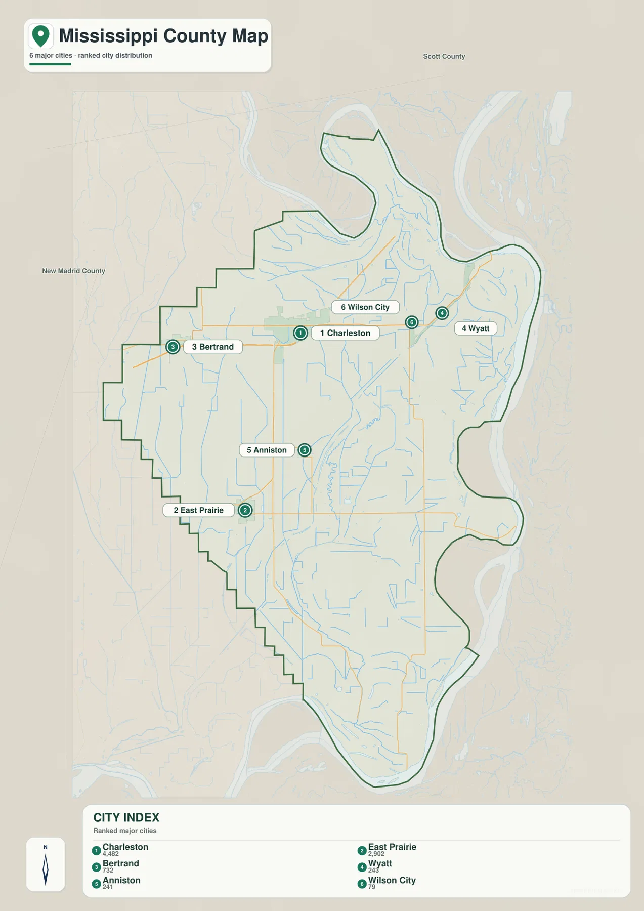
The simplified city map highlights Charleston, East Prairie, Bertrand, Wyatt, Anniston, and Wilson City. Charleston and Bertrand occupy the northern interior, while Wyatt sits farther east near the river. Wilson City appears between Charleston and Wyatt but slightly to the north, creating a small group of northern reference points that is easy to remember before looking at the more detailed road map.
East Prairie is separated from those northern places by a wide stretch of flat countryside and sits in the southwest part of the county. Anniston lies between Charleston and East Prairie but farther east than the direct north-south line between them. The pattern is useful for understanding that Mississippi County does not have one continuous built-up strip; its principal communities are scattered across a large rural landscape.
The city map is intended for orientation rather than route planning. River bends, drainage ditches, bridges, and the available road network can make the real trip between two towns different from what a straight visual comparison suggests. Use the city labels to learn where places sit relative to one another, then return to the county map or a current navigation service when you need a specific route.
River bends, lakes, bayous, and ditches fill the lowland map
The Mississippi River is the dominant water feature, wrapping around the county’s northeast side before running south along much of the eastern boundary. Big Lake and Fish Creek appear inland in the north, while Stevenson Bay and Brewer Lake sit closer to the river. Together they show that water features are not confined to the main channel; the broad plain behind the river contains many smaller lakes and channels.
Near the center of the county, Bayou Ditch crosses the low ground around Henson Lake. Farther south, the map labels Spillman Ditch, Black Bay, Fish Lake Ditch, and Ricefield Pond. The number of named ditches is an important clue to the working landscape because artificial drainage channels help move water across ground where natural elevation differences are small.
Sixmile Pond and James Bayou become useful landmarks in the southern half, and Big Oak Lake stands out close to the county’s lower end. James Bayou runs through terrain that also appears low on the elevation map, providing a clear example of how the water and elevation views complement one another. This map is not a flood-risk product, depth chart, navigation chart, or legal boundary survey; it is a geographic reference for locating named water features.

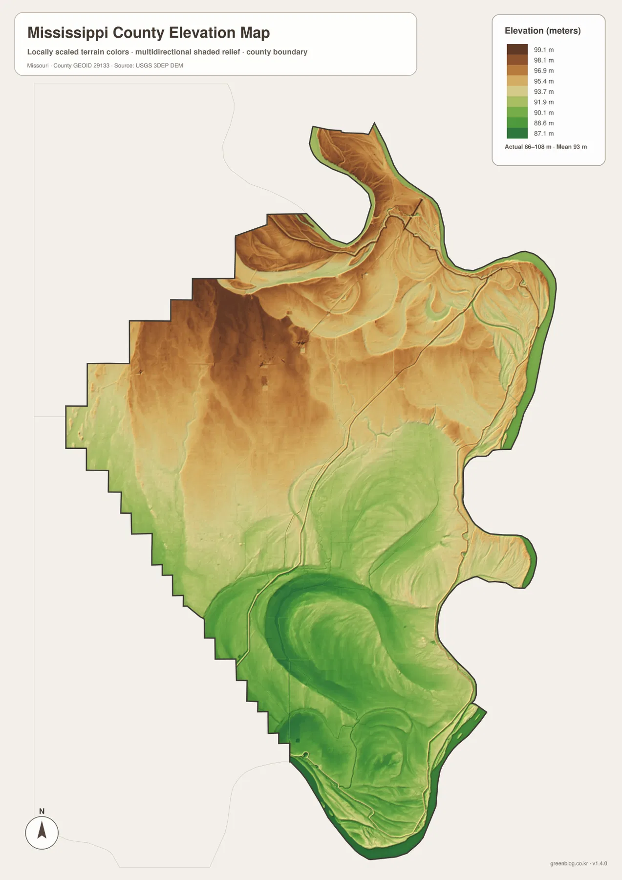
Only 86 to 108 meters, but the north-to-south change is visible
The elevation map shows an actual range of roughly 86 to 108 meters, with a mean near 93 meters. A spread of about 22 meters across the county is small, so Mississippi County should be read as a low plain rather than a landscape of pronounced hills and valleys. Even so, the color scale reveals a consistent difference between somewhat higher northern ground and lower areas farther south.
Brown and tan shades are most noticeable in the north and northwest, including areas west and northwest of Charleston. Green becomes more common through the central-southern part of the county and along much of the Mississippi River edge. Broad curved green areas in the south echo the low ground associated with former channels and drainage features, which becomes easier to recognize when the elevation and water maps are viewed side by side.
The elevation image is designed for county-scale comparison, not site engineering. It can show which parts of the county are generally higher or lower, but it should not be used to determine a building pad elevation, drainage slope, property boundary, or other point-specific measurement. Those decisions require survey-grade or higher-resolution official data for the exact location.
What becomes clearer when the map views are compared
Starting with Charleston makes the four views easy to connect. The road map establishes how the northern routes meet and how the county stretches south. The city map then shows East Prairie standing apart in the southwest, while the water map explains why the eastern boundary is so irregular and why drainage channels occur far from the main river. Finally, the elevation map shows that those waterways occupy a landscape where only modest height differences separate one low area from another.
The WebP previews are convenient for quick browsing, while the downloadable JPG files preserve more detail for printing or enlargement. The ZIP contains the county map, city map, water map, and elevation map shown on this page. They are suitable as general reference graphics, but legal boundaries, property ownership, flood status, and real-time road conditions should always be confirmed with the appropriate current official source.
Frequently Asked Questions
Why is Charleston a useful starting point on the map?
Charleston lies near the center of the northern half of Mississippi County, where routes 60 and 62 provide a strong west-east reference. From there, Bertrand is to the west, Wyatt is toward the river in the east, and the road network continues south toward Anniston and East Prairie.
What does the 86–108 meter elevation range tell me?
It shows that the county is very flat overall. The north is somewhat higher, while the south and much of the river margin are lower, but the total change is modest compared with hilly parts of Missouri. The subtle relief helps explain why drainage ditches and bayous are so prominent.
Can the water map be used to determine flood risk?
No. It shows the locations of rivers, lakes, bayous, ponds, creeks, and drainage ditches for geographic reference. Flood zones, levee conditions, current river stages, and property-specific risk should be checked with current official flood and hydrologic sources.
Map File Information
The download ZIP contains high-resolution JPG versions of the Mississippi County county map, city map, water map, and elevation map.
- File Type: JPG
Related Maps
Sources and References
County boundaries and major road references are supported by U.S. Census Bureau TIGER/Line, waterways by USGS National Hydrography, and elevation data by the USGS 3D Elevation Program. These maps are general county references rather than substitutes for legal surveys or live operational information.
Green Map creates custom-edited map images using open geographic data sources such as geoBoundaries, Natural Earth, OpenStreetMap, and government open data. These maps are edited visual materials, not raw data files, and are provided for education, documents, presentations, and graphic reference.