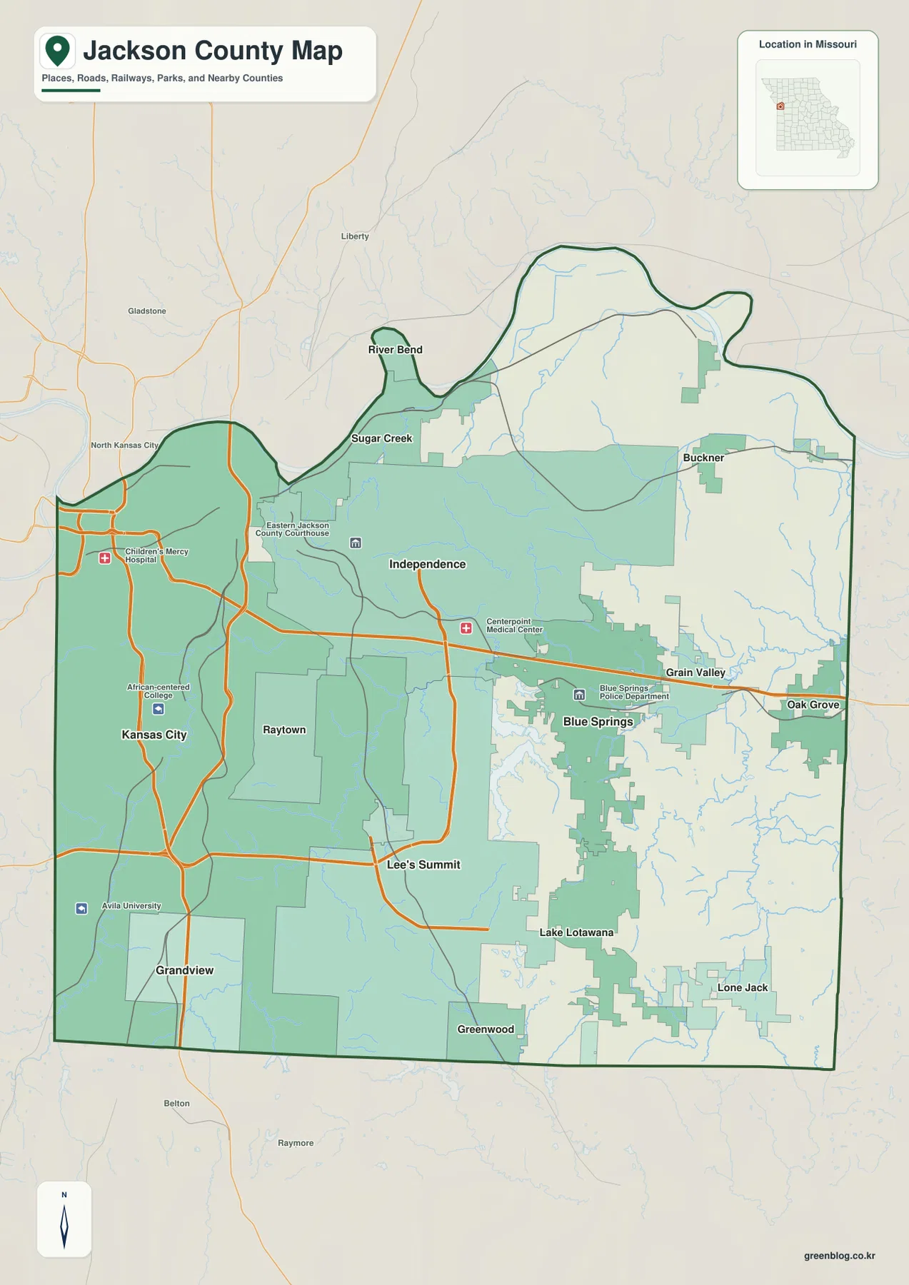
Jackson County occupies the western edge of Missouri and contains a large share of the Kansas City metropolitan area. Kansas City fills much of the west, Independence anchors the center, and Lee’s Summit, Blue Springs, Raytown, and Grandview form additional major urban areas. The Missouri River follows the northern edge, while Blue River, Big Blue River, Little Blue River, and several lakes cut through the developed landscape. The elevation layer spans roughly 213 to 337 meters. High-resolution JPG versions of the same map themes are available together in the ZIP for printing, enlarging labels, or offline reference. High-resolution map files are available for download in the section below.
Unlike many predominantly rural Missouri counties, Jackson County combines continuous metropolitan development with river valleys, reservoirs, and rolling uplands. The western and central cities are closely connected, but the eastern side contains larger gaps between communities and more visible drainage terrain. Comparing the road, city, water, and elevation layers makes the transition from dense urban land to the county’s outer hills and stream valleys easier to see.
Table of Contents
Kansas City and Independence define the western and central core
Kansas City occupies a broad area along the western side of the county, while Independence lies immediately to the east and forms another major urban center. The general map shows multiple major highways and arterial roads linking the two. Jackson County courthouse facilities are also represented within this urban area, reflecting the county’s administrative presence in both Kansas City and Independence.
East of Independence, Sugar Creek and River Bend provide smaller northern references, while Buckner lies farther east. Blue Springs and Grain Valley occupy the east-central corridor. To the south and southwest, Raytown, Grandview, Lee’s Summit, Lake Lotawana, Greenwood, and Lone Jack help show how far the developed metropolitan area extends across the county.
Lee’s Summit and Blue Springs anchor the southeastern metropolitan area
Lee’s Summit occupies a large south-central area and sits between the Kansas City side of the county and the more open eastern landscape. Blue Springs lies northeast of Lee’s Summit, with Grain Valley and Oak Grove extending the urban corridor toward the eastern boundary. Lake Lotawana and Greenwood add smaller community references to the southeast.
Raytown is positioned between Kansas City and Independence on the southwestern side of the central urban area, while Grandview lies farther south. In the western half of the county, city boundaries can be difficult to distinguish without the shaded urban areas and road network. Moving east, the spaces between cities become wider and stream valleys become more prominent.
The city layer ranks six major urban centers
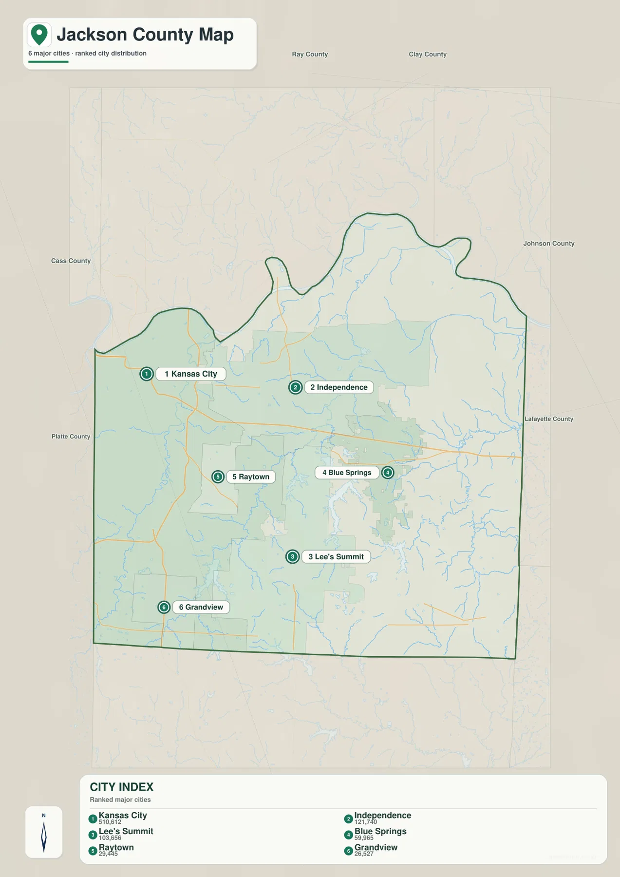
The ranked city map places Kansas City first, Independence second, Lee’s Summit third, Blue Springs fourth, Raytown fifth, and Grandview sixth. The CITY INDEX displays values of 510,612 for Kansas City, 121,740 for Independence, 103,656 for Lee’s Summit, 59,965 for Blue Springs, 29,445 for Raytown, and 26,527 for Grandview. These values belong to the supplied map dataset and should not be treated as current official population estimates.
The distribution is more useful than the raw numbers. Kansas City is west, Independence is central, Lee’s Summit is south-central, Blue Springs is east-central, and Raytown and Grandview lie to the southwest. The numbered markers represent ranking rather than road mileage or travel time.
The Missouri River creates the broad northern lowland
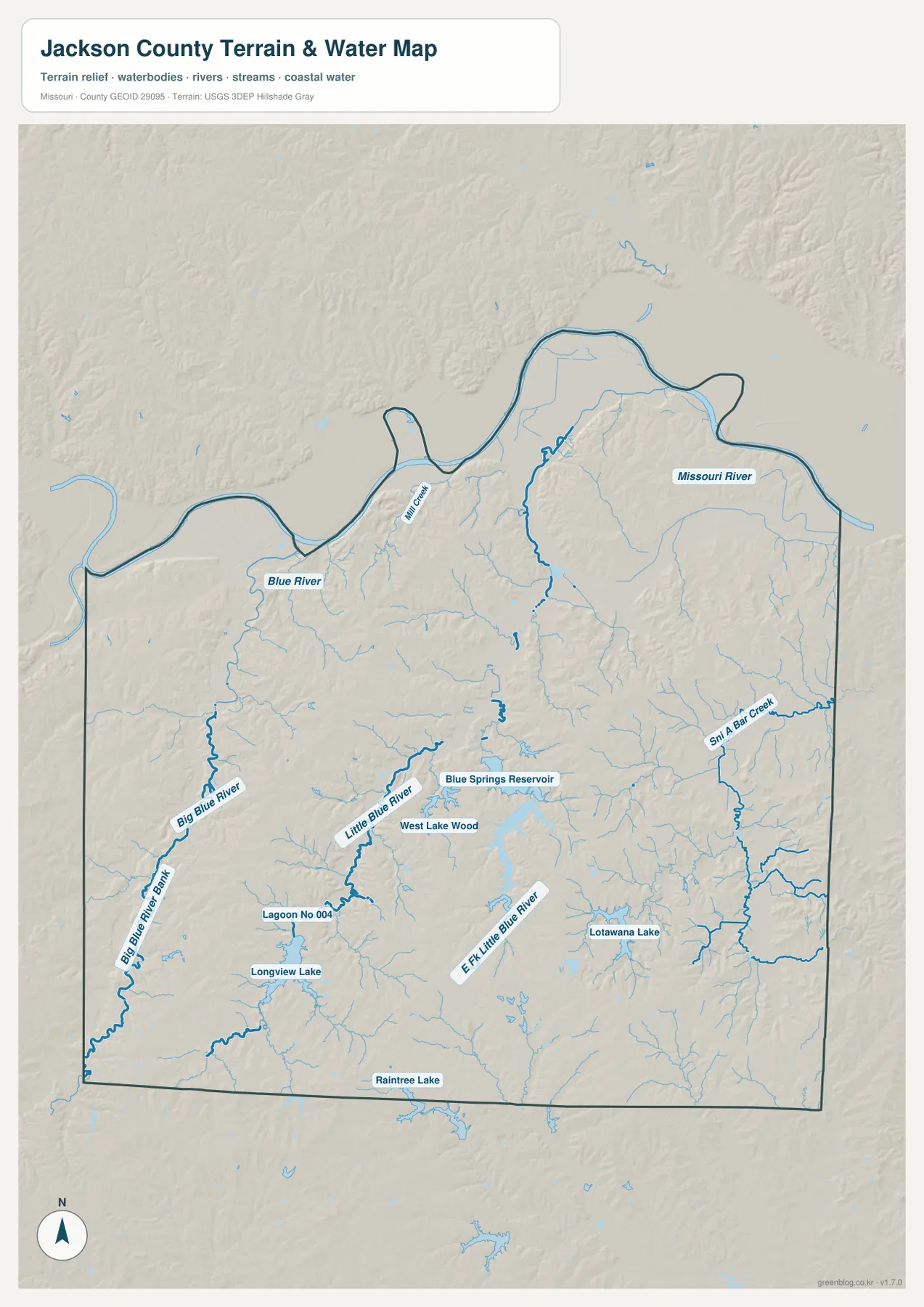
The Missouri River is the largest water feature on the county map and follows much of Jackson County’s northern edge. Its floodplain forms a broad low corridor north of Independence and along the northeastern boundary. On the elevation layer, this river edge is among the darkest green and lowest areas in the county.
Mill Creek and other smaller tributaries descend from the interior toward the Missouri River. The contrast is particularly noticeable north and east of Independence, where the flat river lowland meets more strongly rolling terrain over a short distance. The terrain-and-water layer is intended for geographic reference rather than current river stage, flood forecasting, or legal floodplain decisions.
Blue River and Big Blue River cut through the western urban area
Blue River runs through the western portion of Jackson County, and Big Blue River appears farther south and southwest. These waterways remain visible geographic corridors even within heavily developed parts of Kansas City, Raytown, and the surrounding metropolitan area.
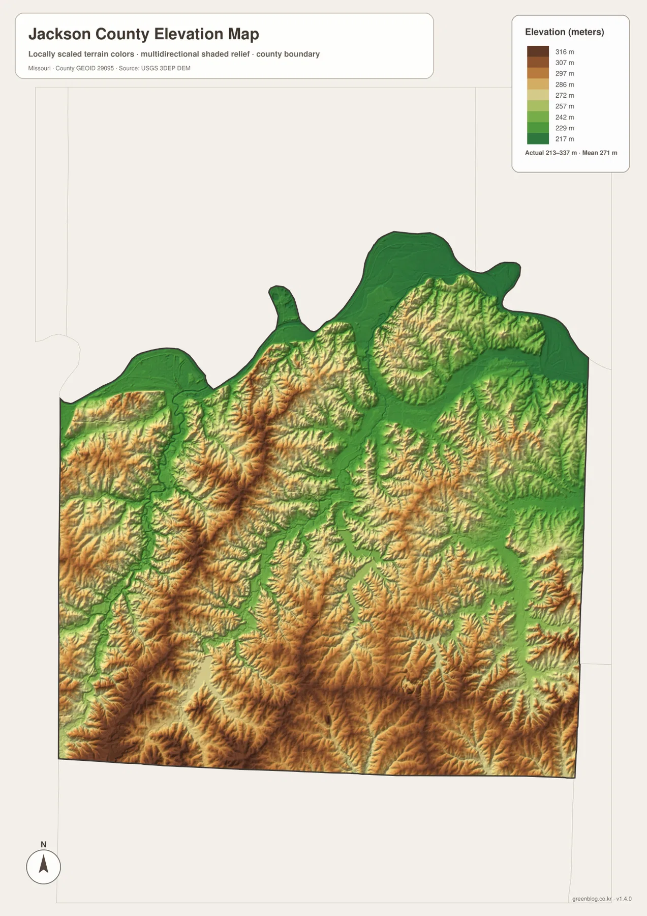
On the elevation layer, the river valleys appear as lower green strips bordered by higher tan and brown uplands. The southwestern part of the county contains some of the stronger relief on the map, so the urban road network overlays a landscape with more local elevation change than a simple city map might suggest.
Little Blue River connects central Jackson County with major lakes
Little Blue River is a major interior drainage and is joined by East Fork Little Blue River. Blue Springs Reservoir appears in the south-central to east-central area, with Longview Lake farther southwest. Lake Lotawana provides another prominent water body southeast of Lee’s Summit, and Raintree Lake is labeled near the southern boundary.
Jackson County Parks + Rec materials identify Blue Springs Lake, Lake Jacomo, and Longview Lake as major park and recreation waters. Fleming Park contains Lake Jacomo and Blue Springs Lake, while Longview Lake Park forms another large recreation area. Those official park references are useful for matching the map’s urban communities with its largest public lake landscapes.
Sni-A-Bar Creek marks the more open eastern side
Sni-A-Bar Creek runs through the eastern side of Jackson County near the Grain Valley and Oak Grove corridor. This area contains fewer continuous urban blocks than the Kansas City–Independence core, and many small tributaries become easier to see on the terrain-and-water layer.
The elevation map shows repeated low creek valleys separated by rolling ridges. That pattern is especially clear east of Blue Springs and south of Buckner, where the urban footprint begins to give way to more open land. The eastern side therefore provides a strong contrast with the densely developed western half.
Elevation ranges from about 213 to 337 meters
The elevation map reports an actual mapped range of approximately 213 to 337 meters, with a mean near 271 meters. The lowest areas follow the Missouri River and major stream valleys. Higher ground is more extensive across the south, southwest, and parts of the interior, where tan and brown ridges rise above the drainage corridors.
The Lee’s Summit and Grandview side contains notable rolling relief, while Big Blue River and its tributaries create lower green channels through the uplands. Little Blue River and eastern creeks produce similar ridge-and-valley patterns. This map is appropriate for county-scale terrain comparison and should not be used as survey-grade or engineering-grade elevation data.
Independence adds a distinct Truman-era historical reference
Independence is one of Jackson County’s major cities and is closely associated with Harry S. Truman. The Harry S. Truman Presidential Library’s educational material describes Independence as the place where Truman grew up, went to school, began his political career, spent much of his private life, and was eventually buried at the presidential library.
The Truman Library itself is in Independence and provides a useful historical landmark within the county’s metropolitan geography. That history also gives the city a role distinct from neighboring Kansas City. The map is useful for locating Independence within the county, while the Truman Library’s official site provides the historical detail.
County government operates across Kansas City and Independence
Jackson County’s official government site lists the Jackson County Courthouse in Kansas City and county facilities in Independence. County Legislature meetings are held in Kansas City, with scheduled meetings also taking place at the Eastern Jackson County Courthouse in Independence. That two-center arrangement fits a county whose services are spread across a large metropolitan area.
County pages provide current information about property assessment, records, elections, parks, and other public services. The map can establish the geographic relationship between Kansas City and Independence, but current office locations, hours, and department contacts should always be checked on the official county website.
Choosing the right downloadable map
Use the general county map for cities and major roads. The ranked city layer is the fastest way to compare Kansas City, Independence, Lee’s Summit, Blue Springs, Raytown, and Grandview. The terrain-and-water map is more useful for the Missouri River, Blue River, Little Blue River, reservoirs, and lakes, while the elevation layer makes the difference between low river corridors and higher southern uplands much clearer.
The download ZIP contains high-resolution JPG versions of the same map themes shown on the page. They are useful for enlarging labels, printing a reference sheet, or comparing layers side by side. The files are intended for general geographic reference and do not replace live navigation, flood warnings, legal boundary surveys, or professional elevation measurements.
Frequently Asked Questions
What is the easiest place to start when reading the Jackson County maps?
Kansas City and Independence are the clearest starting points. Together they occupy much of the western and central county and make it easy to orient Lee’s Summit, Blue Springs, Raytown, Grandview, and the major river corridors.
Do the numbers on the city map show driving distance?
No. They rank Kansas City, Independence, Lee’s Summit, Blue Springs, Raytown, and Grandview within the supplied city dataset. The markers and CITY INDEX values are not road mileage or travel times.
What elevation range does the Jackson County map show?
The elevation layer shows an actual range of about 213 to 337 meters, with a mean near 271 meters. The Missouri River and major stream valleys are lower, while much of the south and southwest is higher and more rolling.
Map File Information
Download the map files associated with this page for reference, printing, and compatible visual projects.
- Included Files: Use only the versions confirmed in the article and supplied images
- File Type: Use the confirmed download contents
- Intended Use: Printing, education, presentations, and map-based projects
Related Maps
Sources and references
- Jackson County, Missouri – Official Website – county government and public services
- Jackson County Parks + Rec – Park Attractions & Maps – Blue Springs Lake, Lake Jacomo, Longview Lake, and park information
- Harry S. Truman Presidential Library – Independence – local history and Truman-related places
- U.S. Census Bureau TIGER/Line Shapefiles – county boundary and road data
- USGS National Hydrography – rivers, streams, and water features
- USGS 3D Elevation Program – elevation data
Green Map creates custom-edited map images using open geographic data sources such as geoBoundaries, Natural Earth, OpenStreetMap, and government open data. These maps are edited visual materials, not raw data files, and are provided for education, documents, presentations, and graphic reference.