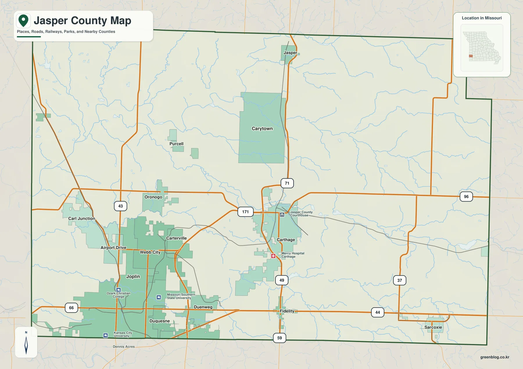
Jasper County occupies southwestern Missouri, where Joplin forms the largest urban center and Webb City, Carterville, Carl Junction, and Duquesne extend the developed area north and east. Carthage provides a second major center farther east. The Spring River and its forks cross the county through broad low valleys, while higher terrain becomes more prominent toward the east and southeast. The general map highlights Route 66, I-44, the 49–71 corridor, Routes 171, 43, 37, and 59, and the elevation layer spans roughly 247 to 369 meters. High-resolution JPG versions of the same map themes are available in the download ZIP for printing and offline reference.
A useful way to read Jasper County is to compare the Joplin–Webb City urban belt with Carthage and the more open eastern countryside. The Spring River system lies between and around these communities, and its valleys explain many of the lower corridors visible on the elevation map. Moving east from the heavily developed southwest, the landscape becomes more rolling and the spacing between towns increases.
Table of Contents
Joplin and Carthage provide two strong county reference points
Joplin occupies the southwestern corner of Jasper County and is the largest urban area on the supplied map. Webb City and Carterville continue north and northeast from Joplin, while Carl Junction lies farther northwest. Carthage forms a separate concentration farther east and is labeled with the Jasper County Courthouse and Mercy Hospital Carthage.
Route 171 provides an important east-west connection between the Joplin side and Carthage, while I-44 crosses the southern county. The 49–71 corridor runs north-south through the Carthage area, and Routes 43, 37, and 59 provide additional local references. The map is intended for county-scale orientation, not current traffic or turn-by-turn navigation.
Webb City, Carterville, and Carl Junction extend the Joplin urban belt
Webb City lies directly north of Joplin, and Carterville occupies the corridor between Webb City and Carthage. Carl Junction is farther northwest near Route 43, while Oronogo sits north of Webb City. Purcell appears still farther north in a more rural setting. Together, these places create a close-spaced cluster that distinguishes western Jasper County from the more widely separated towns farther east.
The northern and eastern county contain places such as Jasper, Carytown, and Sarcoxie, where developed areas are smaller and open land is more prominent. East of Carthage along Route 96, the urban footprint thins quickly and creek valleys and higher ground become easier to see. That contrast helps explain why a single county map can look highly urban in the southwest and much more rural in the east.
The city layer ranks six major communities
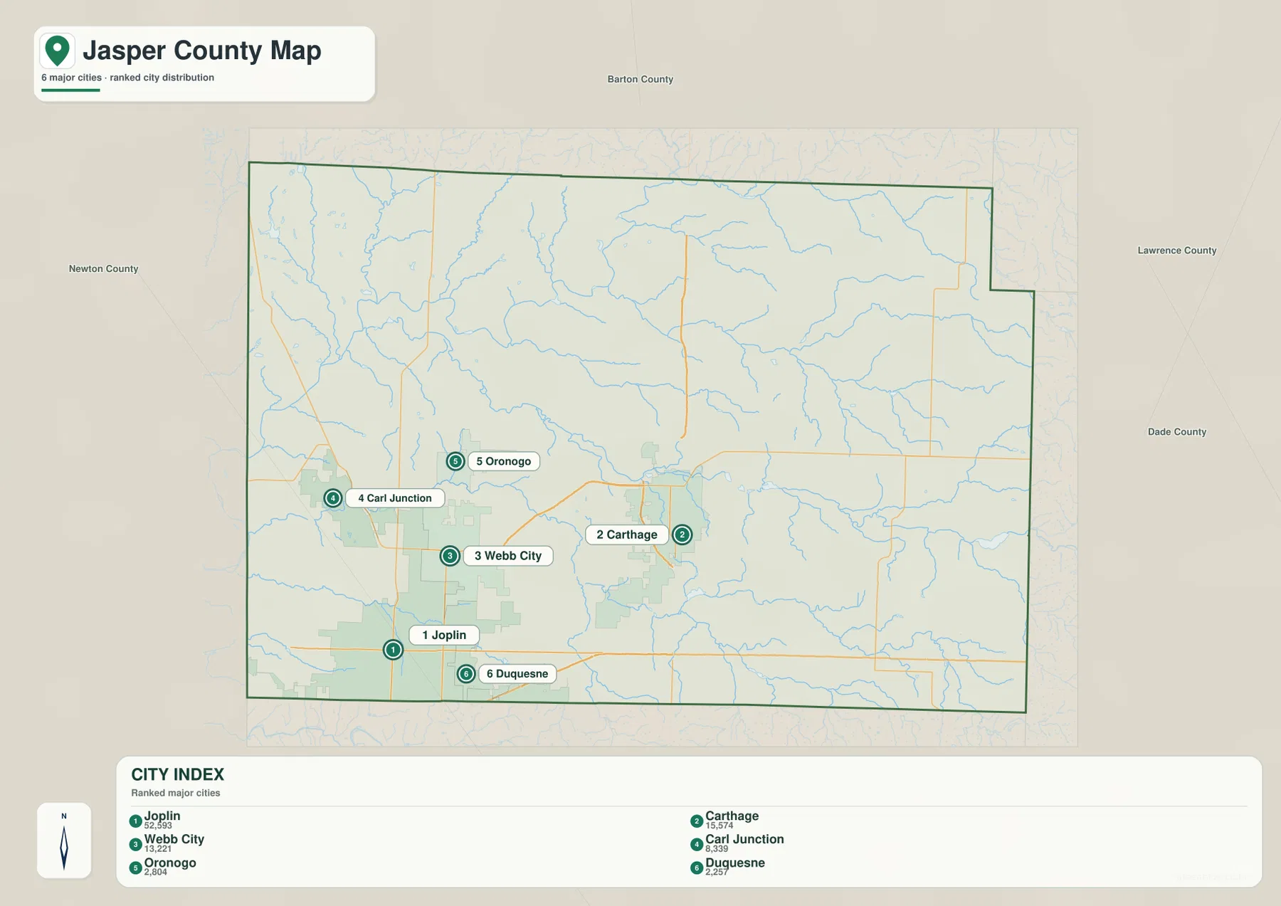
The ranked city map places Joplin first, Carthage second, Webb City third, Carl Junction fourth, Oronogo fifth, and Duquesne sixth. The CITY INDEX displays values of 52,593 for Joplin, 15,574 for Carthage, 13,221 for Webb City, 8,339 for Carl Junction, 2,804 for Oronogo, and 2,257 for Duquesne. These are values associated with the supplied map dataset and should not be treated as current official population estimates.
The distribution itself is more useful than the raw numbers. Joplin, Webb City, and Duquesne cluster in the southwest, with Carl Junction and Oronogo extending the developed area northward. Carthage sits distinctly east of that group as another major center. The numbered markers show rank rather than road mileage or travel time.
Spring River forms the broad central and western low corridor
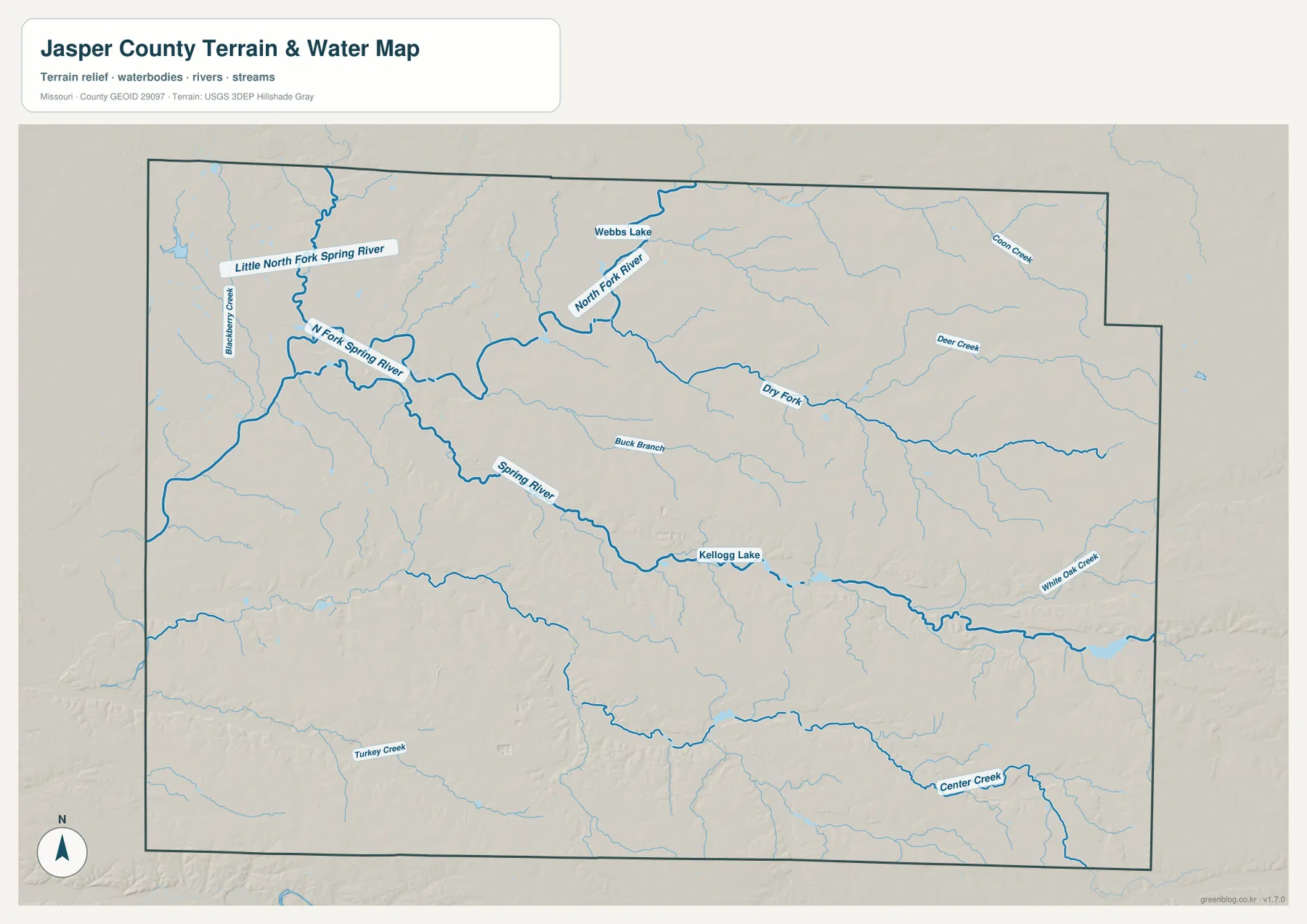
Spring River is the dominant watercourse on the terrain-and-water map. Its system collects water from the northwest and crosses the central part of the county through a broad lower corridor. North Fork Spring River and Little North Fork Spring River join the drainage from the northwest, while Blackberry Creek is one of several smaller named tributaries.
The main Spring River valley is easy to match with the elevation map because it appears as a long green lowland between higher ridges. The river also helps separate parts of the Joplin urban area from Carthage and the eastern uplands. The water layer is a geographic reference rather than a current river-stage or flood-warning product.
Dry Fork and eastern tributaries divide the country east of Carthage
Dry Fork runs through the eastern half of Jasper County and forms one of the most prominent tributary valleys away from the Spring River. Deer Creek and Coon Creek add smaller drainage lines farther north and east. This part of the county has fewer continuous urban blocks and more extensive ridges between streams.
The elevation layer shows the same shift. Much of the east and northeast is higher than the broad Spring River corridor, with yellow, tan, and brown terrain surrounding narrow green valleys. North-central Jasper County also includes the labeled North Fork River and Webbs Lake, which provide useful local references when matching the water and road maps.
Center Creek and southern tributaries add another valley system
Center Creek is a major named stream along the southern and southeastern part of the county. Turkey Creek appears farther southwest, while Buck Branch and several smaller tributaries cross the area south of the Spring River. Kellogg Lake provides a small central water landmark.
White Oak Creek approaches the Spring River system from the east. These smaller waterways may be less obvious on the general road map, but they create distinct lower corridors on the elevation layer. Moving east from Joplin and Duquesne, the valleys remain green while the land between them rises into broader uplands.
Elevation ranges from about 247 to 369 meters
The elevation map reports an actual mapped range of approximately 247 to 369 meters, with a mean near 304 meters. Western Jasper County and the Spring River corridor contain much of the lower green terrain. Higher ground becomes increasingly prominent in the east and southeast, where tan and brown ridges cover larger areas.
Joplin and Webb City sit within the lower western side of the county, while the landscape east of Carthage and toward Sarcoxie rises more consistently. Spring River and Dry Fork cut long lower valleys through the uplands. The map is useful for county-scale terrain comparison but should not be used as survey-grade or engineering-grade elevation data.

Joplin and Webb City grew within the Tri-State mining region
Lead and zinc mining is an important part of Jasper County’s history. Missouri Department of Natural Resources describes Jasper County as the center of the Missouri portion of the Tri-State Mining District, where lead and zinc mining began in the mid-1800s and continued until 1957. Joplin, Webb City, Carterville, and nearby communities developed within that broader mining economy.
The supplied maps are not mine-location maps, so they should not be used to infer where individual historic shafts, waste areas, or cleanup sites are located. The mining history is useful as regional context for the dense western urban corridor and its transportation network. Missouri DNR maintains separate official information about former mining areas, environmental impacts, and restoration work.
Historic Route 66 connects Joplin with Carthage
Historic Route 66 is another strong local reference. Visit Joplin describes the road as running through Joplin along Main Street before heading toward the Kansas state line, while Carthage is also part of the historic Route 66 corridor in southwest Missouri. The route remains an important part of the identity of both cities.
Route 66 is marked on the supplied county map near Joplin. Modern regional travel relies heavily on I-44 and other highways, but the historic road adds useful context for understanding how the southwest Missouri cities developed and connected. Travelers should use current city tourism information for the exact drivable historic alignment and present-day attractions.
Carthage courthouse and Joplin offices reflect two service centers
The official Jasper County County Clerk page lists the Jasper County Courthouse at 302 S Main Street in Carthage and also provides county court services in Joplin. That arrangement reflects the county’s geography: Carthage is the traditional courthouse center, while Joplin is the largest urban area.
On the general map, the courthouse label in Carthage provides an easy administrative landmark. Readers who need a specific county department should check the current official county page before traveling because offices and court functions can be located in different buildings or cities.
Choosing the right downloadable map
Use the general county map for towns and major roads. The ranked city map is best for comparing Joplin, Carthage, Webb City, Carl Junction, Oronogo, and Duquesne. The terrain-and-water map is more useful for Spring River, its forks, Dry Fork, Center Creek, and smaller lakes, while the elevation layer shows the contrast between lower western valleys and higher eastern terrain.
The ZIP contains high-resolution JPG versions of the same map themes shown on the page. They are useful for enlarging labels, printing a reference sheet, or comparing layers side by side. The files are intended for general geographic reference and do not replace live navigation, flood warnings, mine-hazard information, legal boundary surveys, or professional elevation measurements.
Frequently Asked Questions
What are the best places to use as reference points in Jasper County?
Joplin and Carthage are the clearest pair. Joplin anchors the large southwestern urban area, while Carthage is a major eastern city and the location of the Jasper County Courthouse.
Are the city map values current population counts?
They should not be treated as current official population estimates. The values beside Joplin, Carthage, Webb City, Carl Junction, Oronogo, and Duquesne belong to the supplied CITY INDEX dataset, while the numbered markers show rank.
What elevation range does the Jasper County map show?
The elevation layer shows an actual range of about 247 to 369 meters, with a mean near 304 meters. The Spring River and western side are generally lower, while the east and southeast rise into broader uplands.
Map File Information
Download the map files associated with this page for reference, printing, and compatible visual projects.
- Included Files: Use only the versions confirmed in the article and supplied images
- File Type: Use the confirmed download contents
- Intended Use: Printing, education, presentations, and map-based projects
Related Maps
Sources and references
- Jasper County Missouri – County Clerk – Carthage courthouse and Joplin county court information
- Missouri Department of Natural Resources – Southwest Missouri Tri-State Mining District – Jasper County lead-and-zinc mining history and restoration information
- Visit Joplin – Historic Route 66 – Route 66 through Joplin and regional travel context
- U.S. Census Bureau TIGER/Line Shapefiles – county boundary and road data
- USGS National Hydrography – rivers, streams, and water features
- USGS 3D Elevation Program – elevation data
Green Map creates custom-edited map images using open geographic data sources such as geoBoundaries, Natural Earth, OpenStreetMap, and government open data. These maps are edited visual materials, not raw data files, and are provided for education, documents, presentations, and graphic reference.