St. Louis is an independent city on the eastern edge of Missouri, separated from St. Louis County and treated by the U.S. Census Bureau as a county equivalent. The Mississippi River forms the long eastern boundary, while the western edge meets communities in St. Louis County. Within the fixed city boundary, I-70, I-64/U.S. 40, I-44, and I-55 create a dense highway framework around downtown and the surrounding neighborhoods. High-resolution map files are available for download in the section below.
This page separates the city into a general boundary-and-road map, a single-city index map, a terrain-and-water map focused on the Mississippi River and River des Peres, and an elevation map showing roughly 44 to 187 meters of relief. High-resolution JPG originals of all four can be downloaded together in one ZIP for enlargement, A3 printing, classroom materials, reports, or personal reference.
Table of Contents
An independent-city boundary rather than a conventional county
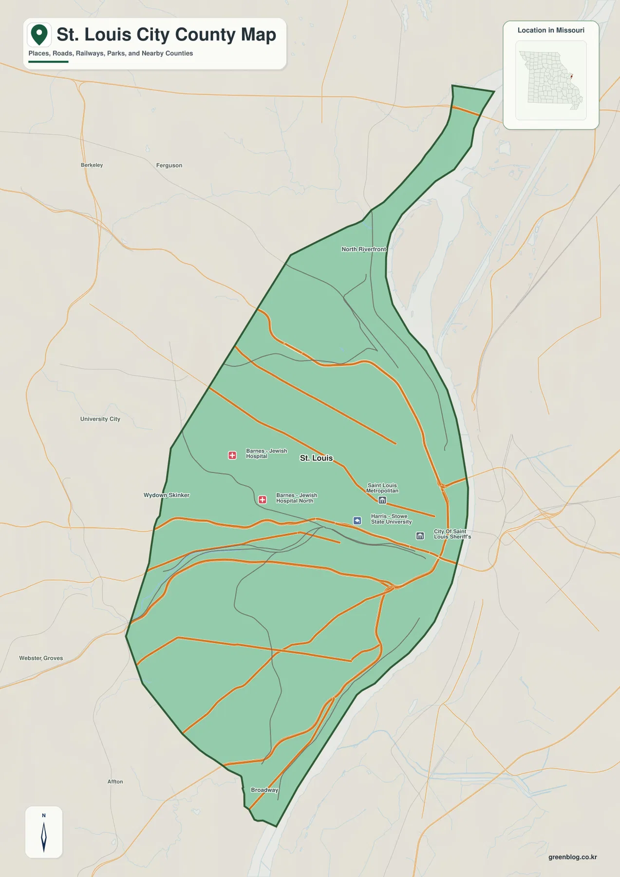
The first thing to understand on the general map is that the City of St. Louis is not inside St. Louis County. The city’s official history explains that the present boundary was established when St. Louis separated from St. Louis County in 1876. That makes nearby places such as Ferguson, University City, Webster Groves, and Affton useful outside references rather than communities within the mapped jurisdiction.
The western city line changes direction several times as it runs north and south, while the Mississippi River provides a much clearer eastern edge. North Riverfront forms a long narrow extension at the top of the map, and the southern boundary narrows toward the Broadway side before meeting the river corridor. Learning this elongated outline first makes the transportation and water maps much easier to read.
Several institutions are labeled near the center, including Barnes-Jewish Hospital and Harris-Stowe State University, while civic and police-related markers appear closer to downtown. Unlike a large rural county map, the St. Louis map shows a dense concentration of roads and urban facilities across most of the jurisdiction.
I-70, I-64, I-44, and I-55 organize the urban road network
St. Louis contains several major interstate corridors within a relatively compact boundary. I-70 serves the northern and Mississippi River side, I-64/U.S. 40 crosses the central city, I-44 approaches downtown from the southwest, and I-55 enters from the south near the river. The city’s official transportation history identifies these routes as the interstate system that reshaped travel between the central city and the surrounding region.
The road pattern becomes especially dense around downtown, where interstate approaches, major arterials, bridges, and local streets come together. Farther west and south, the spacing between the major roads increases even though the city remains continuously developed. Using the river as the eastern reference makes it easier to distinguish the parallel and diagonal highway corridors.
Current city transportation information also covers MetroLink, buses, rail, walking, and bicycling in addition to driving. The map on this page is primarily a geographic road reference rather than a live traffic map, so current closures, construction, and transit schedules should be checked through the appropriate transportation agency.
Why the city index contains only St. Louis
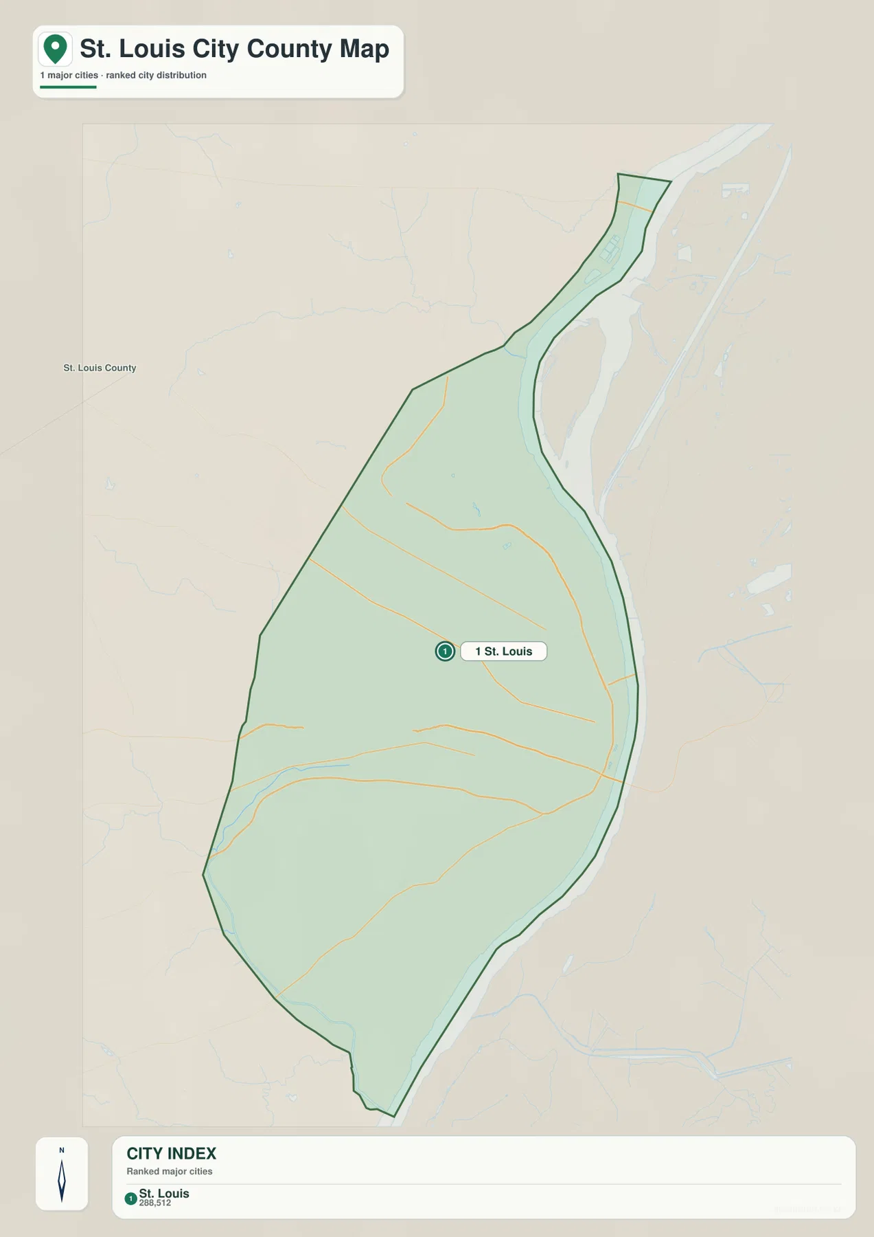
The city map contains a single ranked place: St. Louis, with an index value of 288,512. This is different from most county city maps, where several incorporated municipalities are compared inside one county boundary. Because St. Louis itself is the independent county-equivalent jurisdiction, there is no second incorporated city inside the same mapped boundary.
The simplified city view removes much of the street and facility detail so the relationship between the St. Louis boundary, St. Louis County to the west, and the Mississippi River to the east is easier to see. It is therefore best used as an orientation layer rather than as a neighborhood or municipal-comparison map.
The displayed index number belongs to the map package’s city dataset and should not be treated as a live population count. For current demographic figures, the latest Census Bureau estimates or official City of St. Louis statistics are the appropriate sources.
Mississippi River, River des Peres, and the Chain of Rocks water corridor
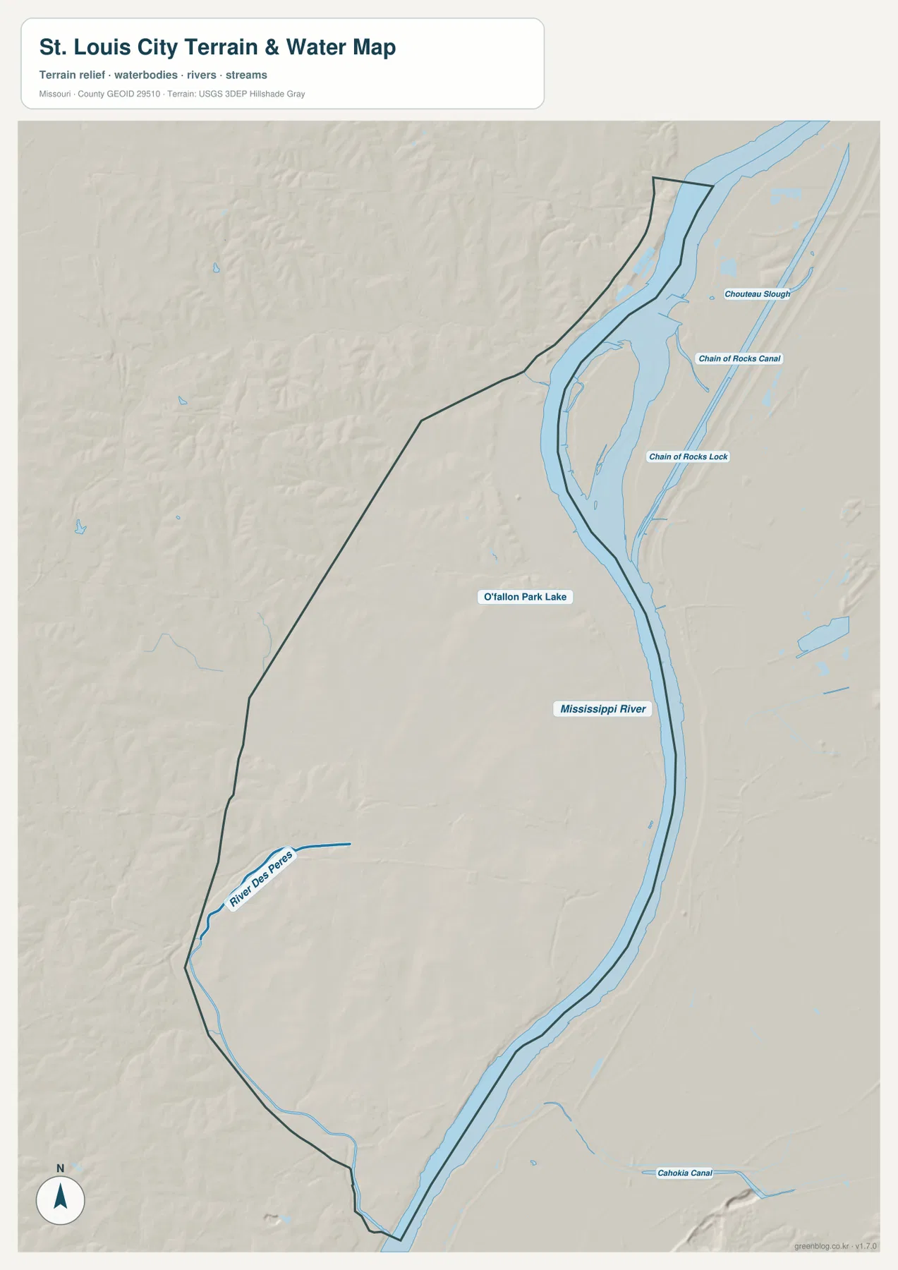
The Mississippi River is the dominant water feature and follows the entire eastern side of the city. Its broad channel and adjacent low ground create a strong contrast with the higher interior neighborhoods. In the north, Chouteau Slough, the Chain of Rocks Canal, and Chain of Rocks Lock appear beside the main river corridor, adding a more complex set of channels and engineered water features.
River des Peres provides the strongest interior water reference in the south and southwest. It approaches the southern edge of the city and continues toward the Mississippi River, forming a lower corridor through terrain that rises noticeably to the west. On the elevation map, this route is visible as a green low zone between higher neighborhoods.
O’Fallon Park Lake is a much smaller waterbody in the north-central city. Although it is minor compared with the Mississippi River, it provides a useful inland landmark and illustrates how the water map combines major rivers, engineered channels, drainage corridors, and urban lakes within one dense metropolitan area.
The terrain-and-water map is intended for geographic reference, not flood determination, river-stage analysis, navigation, levee assessment, parcel boundaries, or legal water boundaries. Mississippi River and River des Peres conditions can change, so current flood or safety decisions require up-to-date official information.
Elevation ranges from about 44 to 187 meters
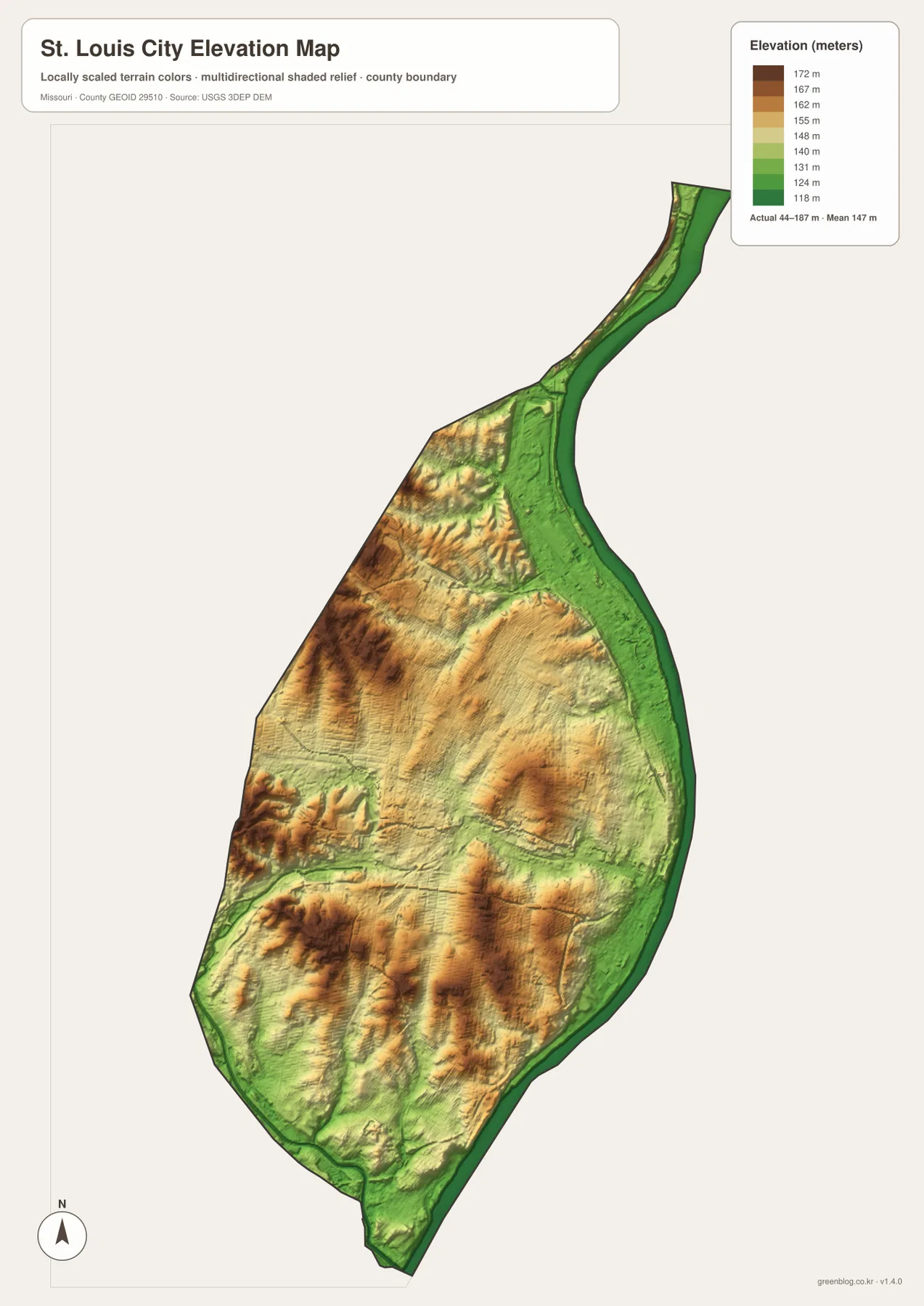
The elevation map reports an actual range of roughly 44 to 187 meters and a mean near 147 meters. The lowest dark-green terrain follows the Mississippi River along the eastern edge, producing a nearly continuous low corridor from the northern riverfront to the southern boundary.
Higher tan and brown terrain occupies much of the west and southwest. Short ridges and shallow valleys create noticeably stronger relief there than along the river. Additional locally high ground appears in the northwest, showing that the city is not simply a flat plain rising evenly away from the Mississippi.
River des Peres forms another lower green corridor through the southwest and south. Central St. Louis sits closer to the citywide mean but still contains repeated local rises and depressions. Comparing the water and elevation maps makes the close relationship between the river corridors and the lowest terrain immediately visible.
This citywide elevation surface is useful for broad relief comparison, not for engineering, construction, drainage design, parcel-level elevation decisions, or survey-grade measurement. Site-specific work requires more detailed official elevation data or field surveying.
Compare the fixed city boundary with highways, river lowlands, and western hills
Start with the Mississippi River as the eastern reference and then trace I-70, I-64/U.S. 40, I-44, and I-55 across the city. The general map is best for roads and institutions, while the city index map provides the simplest view of St. Louis as one independent jurisdiction surrounded by separate municipalities and St. Louis County.
For terrain, begin with the Mississippi River and River des Peres, then locate the Chain of Rocks features and O’Fallon Park Lake. Switching to the elevation map shows why the eastern riverfront and southern drainage corridors appear lower than the western interior.
St. Louis is highly urbanized, but its physical geography still changes substantially over a short distance. The fixed independent-city boundary contains low riverfront land, higher western and southwestern neighborhoods, and a major drainage corridor along River des Peres. Using all four map views together gives a clearer picture than a street map alone.
The downloadable JPG originals contain more pixels than the WebP previews embedded on the page, making them better for enlargement, A3 printing, classroom handouts, reports, and personal reference. They remain general-purpose maps, however. Legal boundaries, live traffic restrictions, flood conditions, and precise site elevations should always be checked against current official sources.
Frequently Asked Questions
Is the City of St. Louis part of St. Louis County?
No. St. Louis separated from St. Louis County in 1876 and is an independent city. The Census Bureau treats it as a county equivalent, which is why this map package uses a county-style boundary, water, and elevation workflow.
How much elevation change is shown across St. Louis?
The elevation map shows an actual range of about 44 to 187 meters with a mean near 147 meters. The Mississippi River corridor is lowest, while western and southwestern terrain rises substantially higher.
Which waterways are the easiest references on the terrain map?
Start with the Mississippi River along the eastern boundary and River des Peres in the south and southwest. In the north, the Chain of Rocks Canal, Chain of Rocks Lock, and Chouteau Slough provide useful additional references.
Map File Information
The download ZIP contains high-resolution JPG versions of the St. Louis City general map, city map, terrain-and-water map, and elevation map.
- File Type: JPG
Related Maps
Sources and References
Boundary and road reference data are supported by U.S. Census Bureau TIGER/Line, water features by USGS National Hydrography, and elevation data by the USGS 3D Elevation Program. The independent-city boundary history is documented by the City of St. Louis history page, and current mobility resources are available through St. Louis City Transportation Information.
Green Map creates custom-edited map images using open geographic data sources such as geoBoundaries, Natural Earth, OpenStreetMap, and government open data. These maps are edited visual materials, not raw data files, and are provided for education, documents, presentations, and graphic reference.