St. Louis County forms most of the suburban ring around the independent City of St. Louis and contains a wide variety of communities, from Florissant and University City in the east and north to Chesterfield, Ballwin, Kirkwood, and the much more expansive Wildwood area in the west. The Missouri River borders the northern side, while higher and much more rugged terrain develops across the west and southwest. High-resolution map files are available for download in the section below.
This page separates those features into a general county map, a ranked city map, a terrain-and-water map, and an elevation map covering roughly 37 to 274 meters of relief. High-resolution JPG originals of all four can be downloaded together in one ZIP for enlargement, A3 printing, classroom materials, reports, or personal reference.
Table of Contents
A county boundary wrapped around the independent City of St. Louis
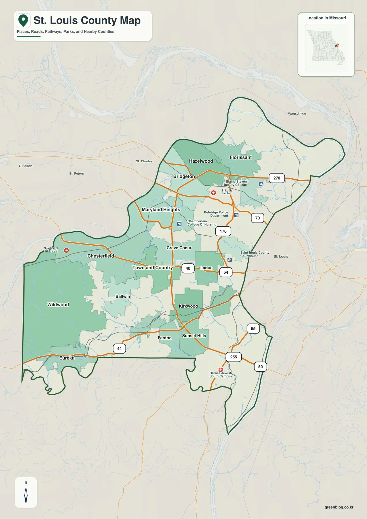
The first important feature on the general map is the county boundary itself. St. Louis city is a separate jurisdiction and appears as an excluded area on the eastern side of the county. That creates a complex outline, with St. Louis County extending north, west, and south of the independent city rather than forming a simple compact shape.
Florissant and Hazelwood provide strong northern references, with Bridgeton farther west. Maryland Heights and Creve Coeur occupy the central-western corridor, Chesterfield lies farther west, and Town and Country, Ladue, Kirkwood, Sunset Hills, and Fenton fill the south-central side. Wildwood and Eureka mark the broad, much hillier western and southwestern portions.
The major highway network includes I-70, I-270, I-170, I-64/U.S. 40, I-44, I-55, I-255, and U.S. 50. I-70 organizes the northern urban corridor, I-64/U.S. 40 runs through the Chesterfield and Ladue side, and I-44 provides the clearest route across Eureka, Fenton, and the southwest. These roads make better first references than the much denser network of local streets.
Clayton is the county seat, and the general map marks the St. Louis County Courthouse in the eastern-central part of the county. Because the suburban area contains so many municipalities, it is often easier to divide the map into broad I-270, I-64/U.S. 40, and I-44 corridors before locating smaller places.
Florissant and Chesterfield lead six widely distributed major cities
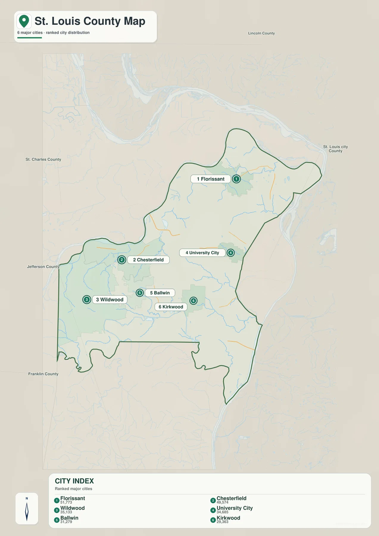
The city map highlights Florissant, Chesterfield, Wildwood, University City, Ballwin, and Kirkwood. The map index labels Florissant with 51,773, Chesterfield with 49,574, Wildwood with 35,133, University City with 34,685, Ballwin with 31,279, and Kirkwood with 29,363. The top two cities sit in very different parts of the county, illustrating how development is spread across multiple suburban corridors.
Florissant anchors the northern urban area, while Chesterfield sits along the western Missouri River side. Wildwood covers a broad southwestern area, University City lies immediately west of the independent city, and Ballwin and Kirkwood provide south-central references. Their distribution shows that St. Louis County is not organized around a single central municipality.
The six-city ranking is only one way to understand the county. Clayton carries major administrative functions, while Maryland Heights, Hazelwood, Creve Coeur, Town and Country, and other municipalities are also prominent on the general map. The ranked view is most useful for quick comparison of several large communities rather than for identifying every important place.
The contrast becomes clearer when the city and elevation maps are compared. Wildwood and parts of Chesterfield extend into hillier western terrain, while Florissant and University City occupy generally lower parts of the metropolitan landscape. Urban development therefore crosses very different physical settings within the same county.
Missouri River lowlands and a dense interior creek network
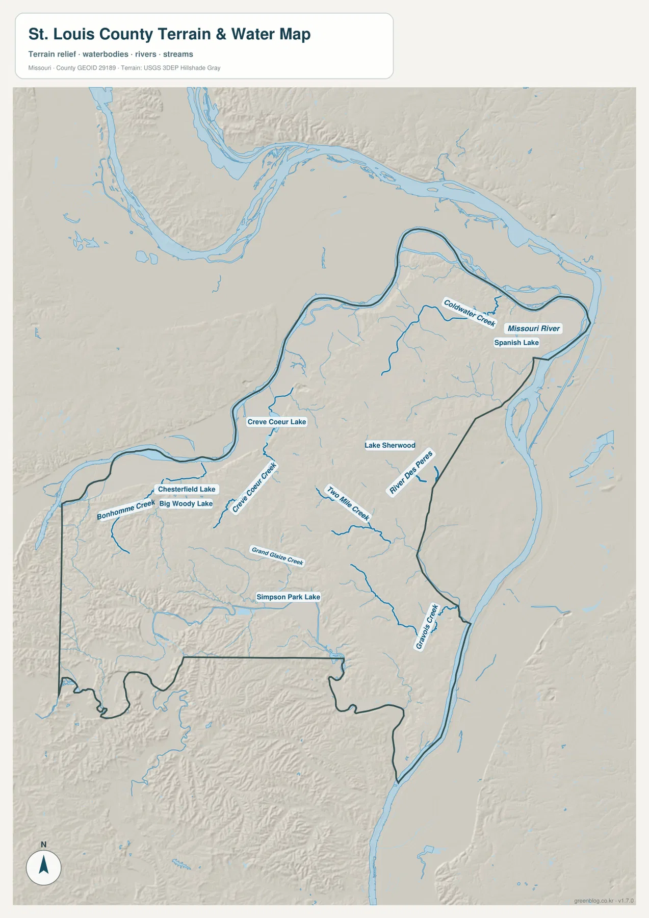
The Missouri River is the dominant water feature along the northern side of the terrain map. Its broad low corridor separates St. Louis County from St. Charles County for much of the northern boundary. Coldwater Creek and Spanish Lake provide additional references in the northeast near the Florissant side.
Creve Coeur Lake and Creve Coeur Creek stand out in the central-western county. Around Chesterfield, Chesterfield Lake, Big Wood Lake, and Bonhomme Creek provide more local water landmarks. Even in heavily developed suburbs, these waterways occupy distinct low corridors that remain easy to trace on both the water and elevation maps.
Farther south, Grand Glaize Creek crosses the south-central county near Simpson Park Lake. Two Mile Creek, River des Peres, and Gravois Creek organize additional drainage closer to the St. Louis city boundary and southeastern county. Lake Sherwood gives another useful inland water reference near the central-eastern side.
The terrain-and-water map is intended for geographic reference, not flood determination, river-stage analysis, navigation, parcel boundaries, or legal water boundaries. Missouri River levels and local creek or lake conditions can change, so current flood or safety decisions should rely on up-to-date official information.
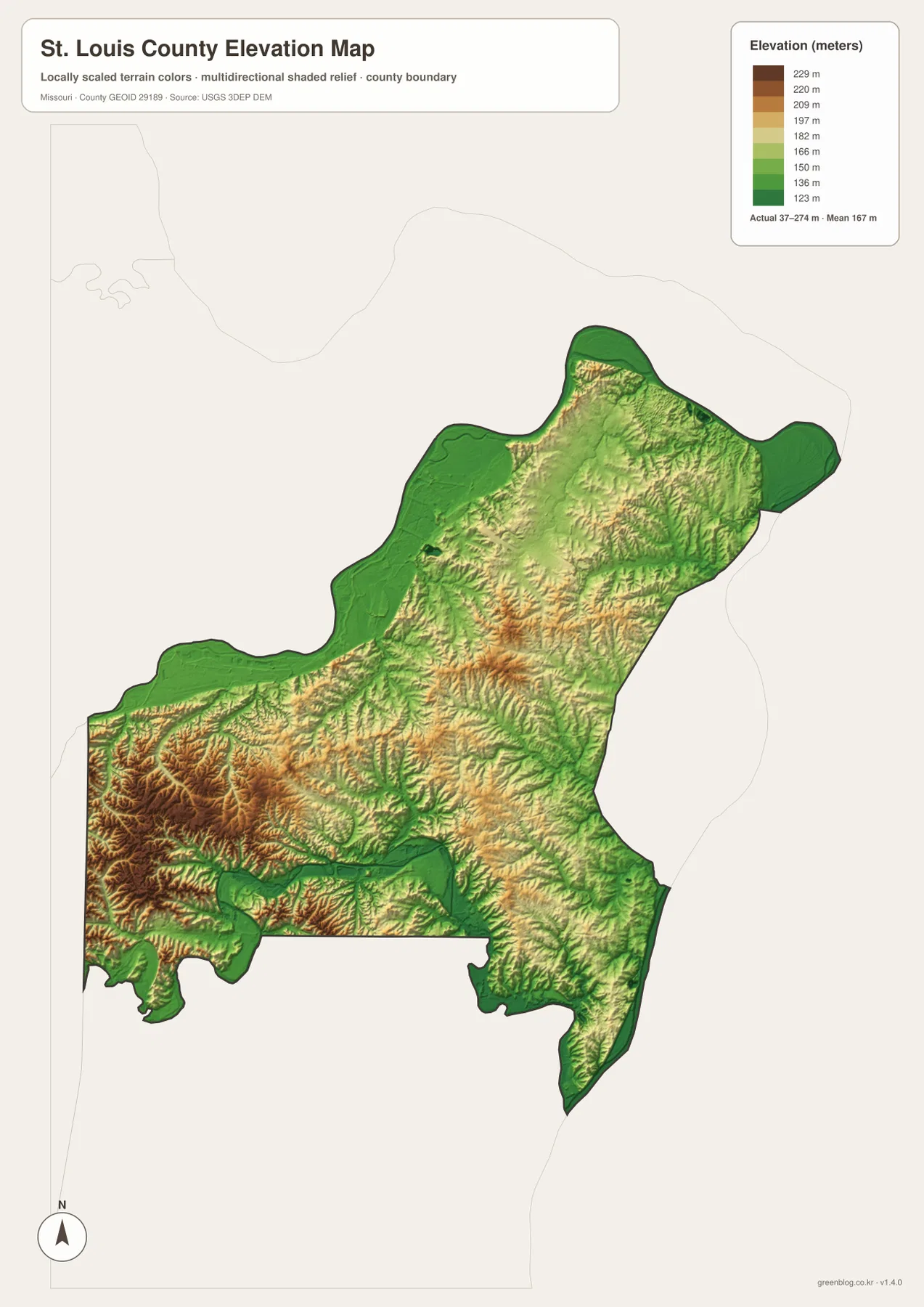
Elevation ranges from about 37 to 274 meters
The elevation map reports an actual range of roughly 37 to 274 meters and a mean near 167 meters. The highest brown terrain is concentrated across the west and southwest, especially around Wildwood, where narrow ridges and stream-cut valleys create the strongest relief in the county.
Chesterfield and the western interior also contain elevated ground, but the terrain drops sharply near the Missouri River and along creek valleys. Creve Coeur Creek and Bonhomme Creek form green lower corridors that divide the higher western terrain into separate ridges.
The northern Missouri River side is much lower, and the eastern inner suburbs generally sit below the western uplands. In the southeast, Gravois Creek and River des Peres create additional lower routes. The county therefore has a strong west-to-river contrast, although local ridges and valleys interrupt any simple one-direction slope.
This county-scale elevation surface is useful for broad relief comparison, not for engineering, construction, drainage design, parcel-level elevation decisions, or survey-grade measurement. Site-specific work requires more detailed official elevation data or field surveying.
Compare suburban corridors with river lowlands and western hills
Start with I-270 when roads and settlement locations matter most. Florissant and Hazelwood sit to the north, Creve Coeur and Chesterfield lie to the west, and Kirkwood, Fenton, and Sunset Hills organize the southern side. I-64/U.S. 40 and I-44 then provide clear east-west references through the central-western and southwestern suburbs.
For terrain, begin with the Missouri River and Creve Coeur Creek, then compare Bonhomme Creek, Grand Glaize Creek, and River des Peres. Switching to the elevation map shows that these waterways occupy lower green corridors while Wildwood and much of the western county rise substantially higher.
St. Louis County is intensely urbanized, but its physical landscape is far from uniform. The north contains broad river lowlands, the west and southwest are strongly hilly, and interior creeks repeatedly divide the suburban terrain. Using the road, city, water, and elevation maps together provides a much clearer picture than any one layer alone.
The downloadable JPG originals contain more pixels than the WebP previews embedded on the page, making them better for enlargement, A3 printing, classroom handouts, reports, and personal reference. They remain general-purpose maps, however. Legal boundaries, live traffic restrictions, flood conditions, and precise site elevations should always be checked against current official sources.
Frequently Asked Questions
Are St. Louis County and the City of St. Louis the same jurisdiction?
No. The City of St. Louis is an independent city separate from St. Louis County. On the county map it appears as an excluded jurisdiction on the eastern side, while Clayton serves as the county seat for St. Louis County.
How much elevation change is shown across St. Louis County?
The elevation map shows an actual range of about 37 to 274 meters with a mean near 167 meters. Missouri River and creek corridors are low, while Wildwood and much of the western and southwestern county rise much higher.
Which waterways are the best starting points on the terrain map?
Start with the Missouri River along the north and Creve Coeur Creek in the central-western county. Bonhomme Creek, Grand Glaize Creek, and River des Peres provide additional references for the west, south-central, and southeastern drainage areas.
Map File Information
The download ZIP contains high-resolution JPG versions of the St. Louis County general map, city map, terrain-and-water map, and elevation map.
- File Type: JPG
Related Maps
Sources and References
Boundary and road reference data are supported by U.S. Census Bureau TIGER/Line, water features by USGS National Hydrography, and elevation data by the USGS 3D Elevation Program. County government and administrative information is available from the official St. Louis County website.
Green Map creates custom-edited map images using open geographic data sources such as geoBoundaries, Natural Earth, OpenStreetMap, and government open data. These maps are edited visual materials, not raw data files, and are provided for education, documents, presentations, and graphic reference.