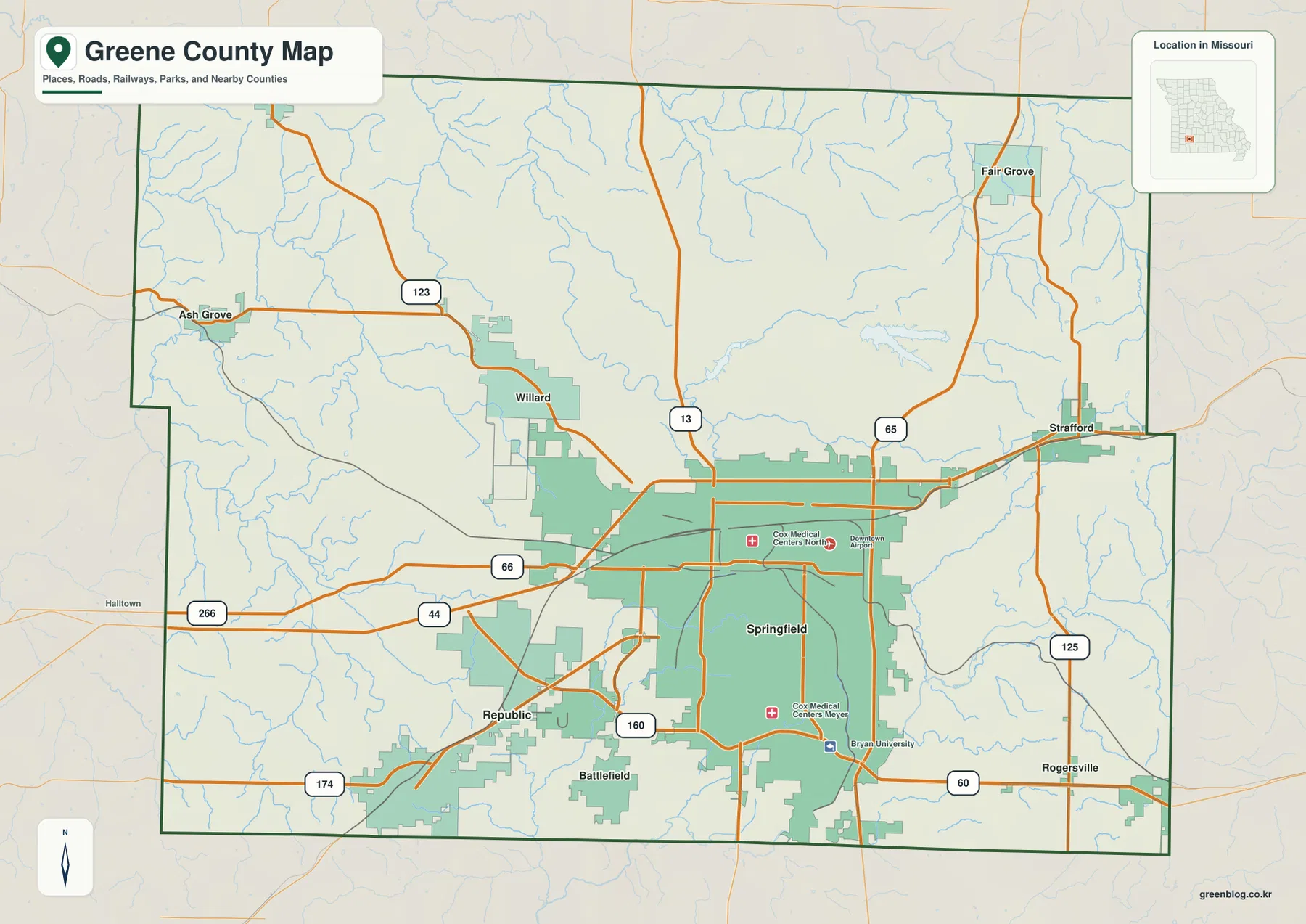
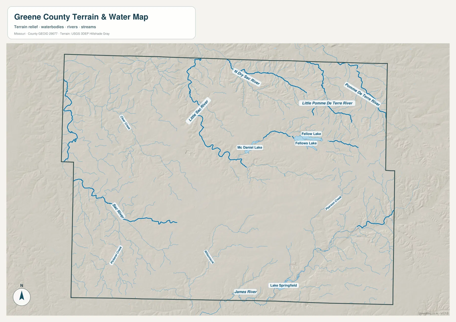
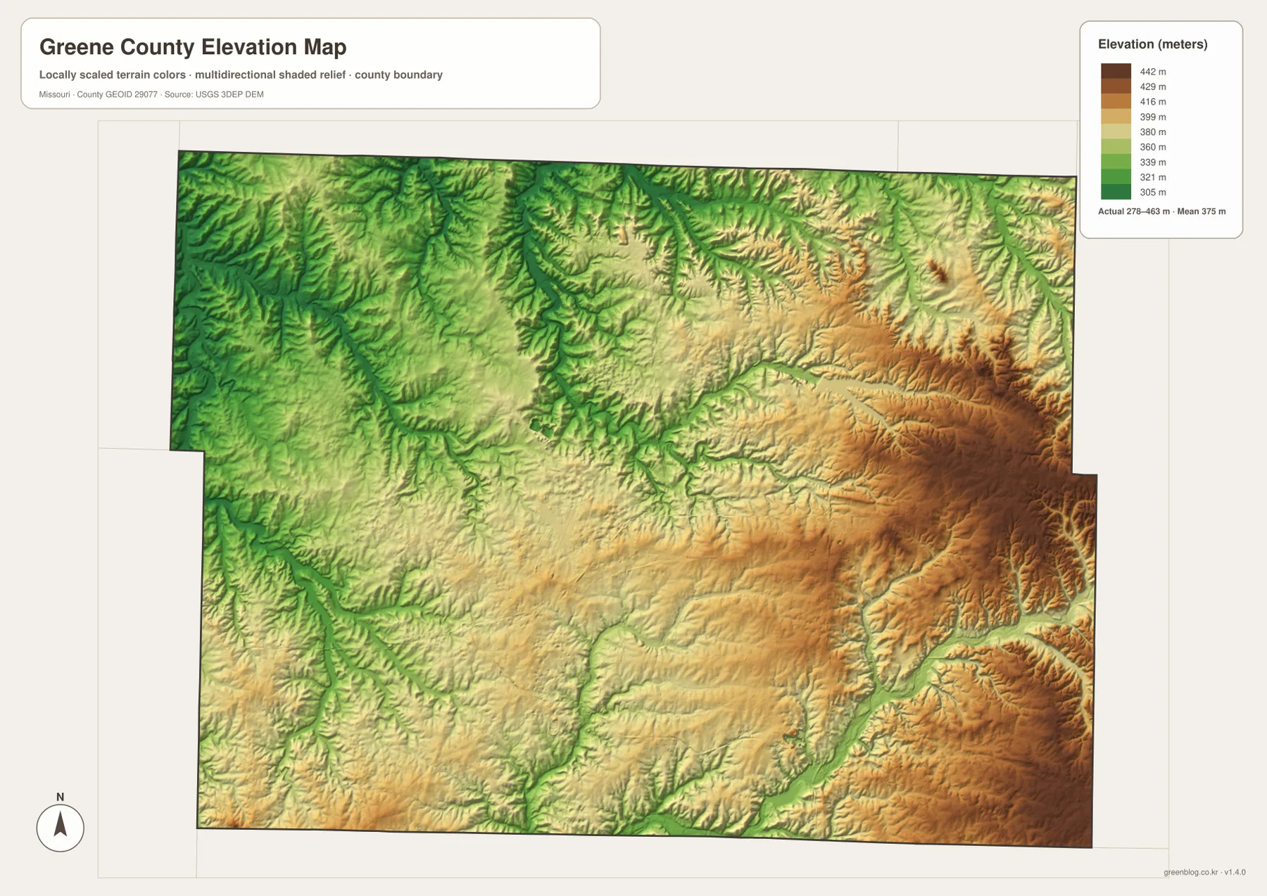
Greene County sits in southwestern Missouri, where Springfield forms a large urban core surrounded by Republic, Willard, Battlefield, Strafford, Rogersville, Fair Grove, Ash Grove, and broad rural areas. The general map highlights I-44, U.S. 65, Route 13, U.S. 60, Route 160, and several state highways. The terrain-and-water layer adds the Little Sac River, North Sac River, James River, Pomme de Terre River, and several important lakes. The elevation map then shows a county-scale range of roughly 278 to 463 meters. High-resolution JPG versions of the same map themes are available together in a ZIP for printing, enlarging labels, or offline reference. High-resolution map files are available for download in the section below.
Greene County differs from many rural Missouri counties because the Springfield urban area occupies a large part of the center and south. Just beyond that developed area, however, the landscape quickly becomes a mix of creek valleys, rolling Ozark uplands, and smaller communities. Looking from Ash Grove in the west to Fair Grove and Rogersville in the east makes the contrast especially clear.
Table of Contents
Start with Springfield, I-44, and U.S. 65
Springfield is the dominant place on the general map and the easiest anchor for the entire county. I-44 runs east-west across the northern side of the urban area, while U.S. 65 forms a strong north-south reference on the east. Route 13 approaches from the north, U.S. 60 helps organize the southeastern side, and Route 160 is useful around Republic and the southern edge of Springfield. Cox Medical Centers North and Meyer, along with Bryan University, provide additional labels inside the metropolitan area.
Willard lies northwest of Springfield, Republic is southwest, and Battlefield is directly south of the main urban area. Strafford sits east along the I-44 corridor, Rogersville is farther southeast near U.S. 60, and Fair Grove occupies the northeastern part of the county. The map therefore shows both a large metropolitan center and a ring of smaller towns separated by rural land.
Ash Grove and Willard mark the west, while Strafford and Rogersville mark the east
Ash Grove is close to the western county line and is connected eastward by Route 123. Willard lies closer to Springfield’s northwestern edge, where the urban footprint begins to give way to a more rural road network. Moving west from Springfield, small streams and open land become more prominent than continuous development.
On the eastern side, Strafford is closely associated with the I-44 corridor, while Rogersville appears farther south near U.S. 60. Fair Grove provides a separate northeastern reference. Comparing these towns reveals how major roads radiate from Springfield but still leave broad areas of rolling countryside between the smaller communities.
Six ranked cities summarize the urban pattern
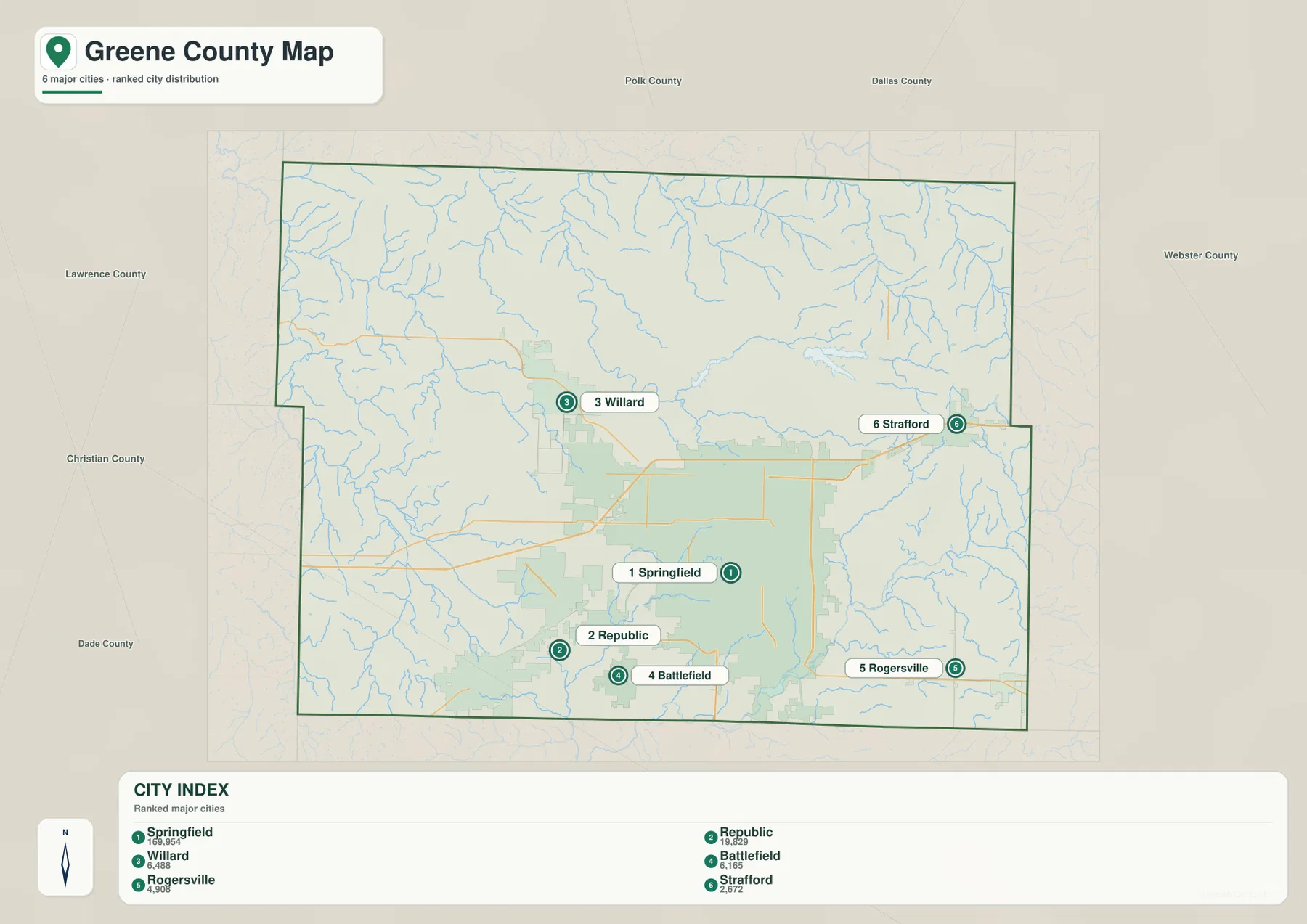
The city distribution map ranks Springfield first, Republic second, Willard third, Battlefield fourth, Rogersville fifth, and Strafford sixth. The CITY INDEX also displays values of 169,954 for Springfield, 19,829 for Republic, 6,488 for Willard, 6,165 for Battlefield, 4,908 for Rogersville, and 2,672 for Strafford. These are values attached to the map’s city-ranking dataset and should not be treated as current official population estimates.
The geography is more important than the numbers. Springfield occupies the center and south, Republic and Battlefield cluster to the southwest and south, Willard lies northwest, Strafford is east, and Rogersville is southeast. The numbered markers are ranking labels, not measurements of driving distance or travel time.
Little Sac River and North Sac River define the northern valleys
The Little Sac River is one of the most prominent watercourses in northern Greene County. It bends southward through the north-central area, while North Sac River approaches from the northeast. Numerous smaller tributaries feed both systems, producing a dense pattern of narrow valleys north of Springfield.
McDaniel Lake is shown along the Little Sac River corridor, and Fellows Lake lies farther east. These two water bodies are among the easiest landmarks on the northern water map. Their locations also correspond with lower terrain on the elevation layer, making them useful for comparing water features with the surrounding ridges.
Pomme de Terre River adds a separate northeastern drainage
The northeastern part of the water map labels Pomme de Terre River and Little Pomme de Terre River. These channels occupy rolling country east and northeast of Fair Grove and are surrounded by many short tributaries. This part of Greene County looks quite different from the broad Springfield urban area, with narrow valleys separating higher Ozark ridges.
The elevation layer reinforces that contrast. Warmer colors become more common toward the east, while creek channels remain lower. The water map is intended for general geographic reference rather than real-time flood conditions, so current river stages and warnings should be checked through official hydrologic sources when needed.
James River and Lake Springfield organize the southern drainage
James River appears along the southern side of the county and provides a major natural reference below Springfield. Lake Springfield lies southeast of the city and occupies a long, low corridor on the water map. On the elevation layer, the river and lake sit within green valley terrain bordered by higher ridges to the east and southeast.
Sac River is labeled farther southwest, and smaller channels such as Pickering Creek and Patterson Creek add detail to the southern and eastern sides. Even within a heavily developed county, these river valleys remain important geographic features. Comparing the road map with the water layer helps explain why developed areas, highways, and natural corridors form the patterns they do.
Elevation ranges from about 278 to 463 meters
The elevation map reports an actual mapped range of approximately 278 to 463 meters, with a mean near 375 meters. Lower green terrain is widespread in the west and northwest and follows many of the major creek valleys. The east and southeast contain more tan and brown shading, indicating higher Ozark uplands.
Higher terrain in the eastern half is not one continuous mountain. It is divided by many branching valleys associated with the Pomme de Terre system, Patterson Creek, James River tributaries, and other streams. The western side is generally lower but still includes rolling hills and incised creeks. This layer is designed for county-scale terrain comparison and should not replace survey-grade or engineering-grade elevation data.
Springfield’s urban footprint sits inside a varied Ozark landscape
The size of Springfield can make Greene County look primarily urban on the general map, but the water and elevation layers reveal a more varied landscape. North of the city, the Little Sac River and Fellows Lake occupy rolling rural terrain. East toward Strafford and Rogersville, higher ridges become more obvious. West toward Republic and Willard, the terrain is generally gentler but still divided by small streams.
A practical way to read the set is to locate a town on the general map, identify a nearby river or lake on the water layer, and then check the same location on the elevation map. Repeating that process around Springfield, Fair Grove, and Rogersville quickly shows how roads and urban development sit within the larger Ozark terrain.
County government information is centered in Springfield
Greene County’s official website provides access to county services including property assessment, records, road closures, planning, and zoning. The Greene County Clerk’s office is located at the Historic Courthouse at 940 N Boonville Ave in Springfield, connecting the map’s largest city with the county’s administrative services.
Greene County’s official historical material states that the county was organized in 1833 and that early county court sessions were held in Springfield. The modern metropolitan area is very different from the early county seat, but Springfield has remained central to county government. For current hours, contacts, and services, the county’s official pages are the appropriate source.
Choosing the right downloadable map
Use the general county map for communities and highways, and the ranked city layer for a quick comparison of Springfield, Republic, Willard, Battlefield, Rogersville, and Strafford. The water map is best for the Little Sac, North Sac, Pomme de Terre, and James river systems as well as the major lakes. The elevation map gives the clearest view of the lower west and the higher eastern uplands.
The ZIP contains high-resolution JPG versions of the same map themes shown on the page. They are useful for enlarging labels, printing a reference sheet, or comparing layers side by side. The files are intended for general geographic reference and do not replace live navigation, flood warnings, legal boundary surveys, or professional elevation measurements.
Frequently Asked Questions
What is the easiest place to use as a reference in Greene County?
Springfield is the clearest starting point. It occupies a large central area and is connected with I-44, U.S. 65, Route 13, U.S. 60, Route 160, and many local roads, making the surrounding towns easy to orient.
Do the numbers on the city map show distance?
No. They rank Springfield, Republic, Willard, Battlefield, Rogersville, and Strafford within the supplied city dataset. The markers and CITY INDEX values are not road mileage or travel times.
What elevation range does the Greene County map show?
The elevation layer shows an actual range of about 278 to 463 meters, with a mean near 375 meters. The western side is generally lower, while higher Ozark uplands are more extensive in the east and southeast.
Map File Information
Download the map files associated with this page for reference, printing, and compatible visual projects.
- Included Files: Use only the versions confirmed in the article and supplied images
- File Type: Use the confirmed download contents
- Intended Use: Printing, education, presentations, and map-based projects
Related Maps
Sources and references
- Greene County Missouri Official Website – current county services and official information
- Greene County Clerk – county clerk office at the Historic Courthouse in Springfield
- History of Greene County, Missouri – county organization and early Springfield history
- U.S. Census Bureau TIGER/Line Shapefiles – boundary and road data
- USGS National Hydrography – rivers, streams, and water features
- USGS 3D Elevation Program – elevation data
Green Map creates custom-edited map images using open geographic data sources such as geoBoundaries, Natural Earth, OpenStreetMap, and government open data. These maps are edited visual materials, not raw data files, and are provided for education, documents, presentations, and graphic reference.