Washington County stretches along Minnesota’s eastern edge beside Wisconsin, with the St. Croix River forming the defining boundary for much of its length. The county changes noticeably from south to north: Woodbury, Oakdale, and Cottage Grove form a dense southern suburban group, Stillwater occupies a prominent river position in the middle, and Hugo, Forest Lake, Scandia, and Marine on St. Croix spread across a more open northern landscape. The page combines roads and settlements with water and elevation, and the high-resolution originals of all four maps can be downloaded together as JPG files in the ZIP box below. High-resolution map files are available for download in the section below.
The strongest geographic reference is the St. Croix River. It runs down the east side past Marine on St. Croix, Stillwater, and Afton, while the Mississippi River meets the county at the far south. Between those two large rivers is an interior full of smaller lakes, streams, ridges, and shallow valleys. Big Marine Lake, Big Carnelian Lake, Lake Elmo, Sunrise River, and Silver Creek are among the named features that make the county much more varied than a simple suburban-edge map would suggest.
Table of Contents
Woodbury, Oakdale, and Stillwater anchor the southern half
Woodbury is the clearest urban anchor in the southern part of Washington County. Its developed area occupies a large block near the southwest side of the county, with Oakdale and Lake Elmo immediately to the north and Afton toward the St. Croix River. Cottage Grove extends farther south, while Newport sits close to the Mississippi River and the county’s southwestern notch. On the general map, municipal boundaries and road density make this southern cluster look very different from the wider spacing found north of Stillwater.
Stillwater is easy to identify because it sits directly beside the St. Croix River. Minnesota 95 follows the river corridor through this part of the county, and the road network links Stillwater westward toward Grant, Mahtomedi, Oakdale, and the broader Twin Cities area. That position gives Stillwater a different geographic role from Woodbury: Woodbury belongs to the dense southern suburban belt, while Stillwater is a river city framed by steep valley terrain on one side and inland roads on the other.
At the south end, U.S. 61 and U.S. 10 appear near the Cottage Grove and Mississippi River corridor. Farther north, a separate set of routes serves Forest Lake, Hugo, and Scandia. The road pattern therefore does not behave like one continuous urban grid. It tightens in the south, loosens through the middle, and spreads across larger blocks in the north. This general map is best for orientation rather than live navigation; construction, closures, and turn restrictions should always be checked with current transportation information.
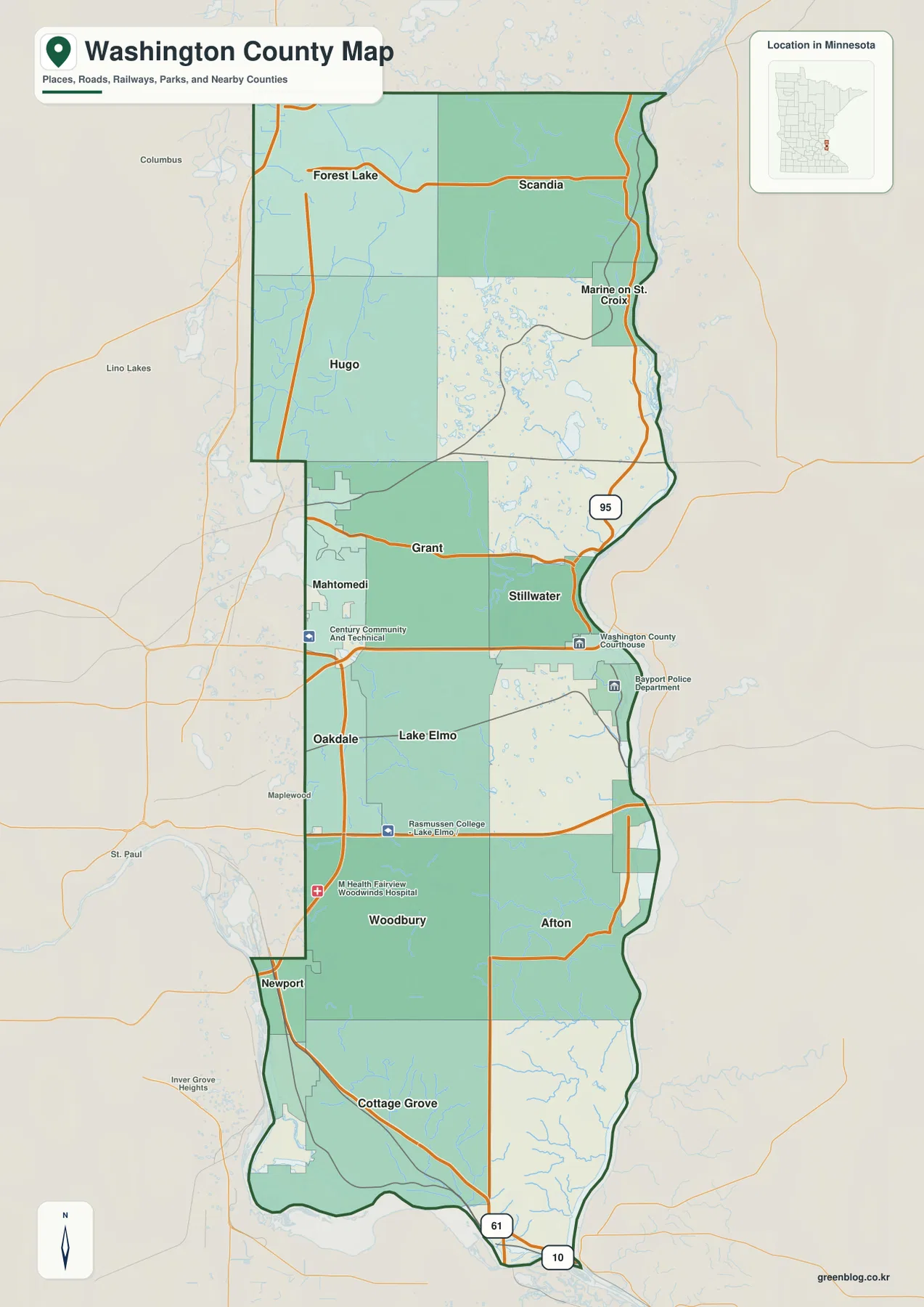
The surrounding geography helps explain the county’s unusual outline. St. Paul, Maplewood, and Lino Lakes lie to the west, while Wisconsin is across the St. Croix River to the east. The Mississippi River curves along the southern end. Instead of a simple rectangular border, Washington County has a long river-defined eastern side and an irregular southern edge, so the shape of the county is closely tied to the two major rivers around it.
Six highlighted cities reveal three different settlement zones
The city map ranks six major communities and makes their north–south distribution especially clear. Its CITY INDEX lists Woodbury at 78,305, Cottage Grove at 40,992, Oakdale at 28,585, Forest Lake at 20,729, Stillwater at 19,355, and Hugo at 16,340. Those figures are best treated as the reference values used on this map rather than as a substitute for a current Census table. The useful point is the contrast in city size and location across the county.
Woodbury, Cottage Grove, and Oakdale cluster in the southern half, where municipal boundaries are close together. Forest Lake and Hugo sit much farther north and west, separated from the southern group by a more open middle section. Stillwater occupies a third setting altogether: it is farther east than the other highlighted cities and sits beside the St. Croix River. The county therefore makes more sense as a southern urban cluster, a central river city, and a northern Forest Lake–Hugo group than as a single chain of equally spaced towns.
Forest Lake is the easiest northern reference point because it sits near the northwest side of the county and near several important roads and lakes. Hugo lies south of it and marks the transition toward the more developed southern area. Stillwater provides the eastern comparison point. Once these three positions are fixed, Woodbury, Oakdale, and Cottage Grove can be placed much more easily, and the long vertical proportions of Washington County become obvious.
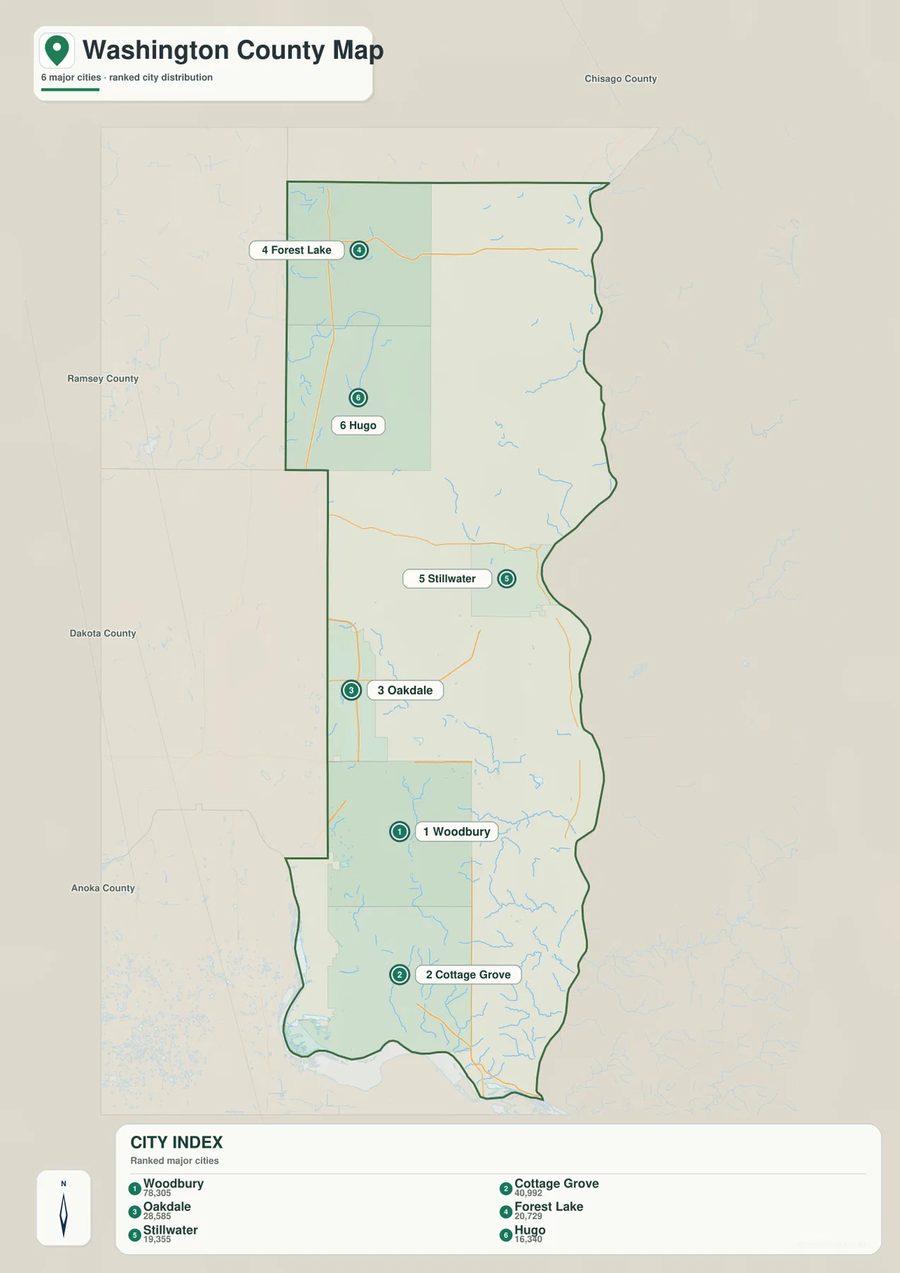
This is not a route-distance diagram. It does not claim that straight lines between the highlighted cities represent roads or driving mileage. Its value is visual comparison: it shows where the six communities sit and how strongly the county’s population centers are weighted toward the south. For actual travel between Woodbury, Stillwater, Forest Lake, and the other cities, the road map or a current navigation service is the appropriate next step.
The St. Croix and Mississippi frame a lake-and-stream interior
The St. Croix River dominates the eastern water boundary from the northern part of Washington County down past Stillwater and Afton. At the opposite end, the Mississippi River forms the major southern water reference. Between them, the interior water map is surprisingly busy. Rather than one large central river, Washington County contains many lakes and shorter tributaries that drain toward the St. Croix, the Mississippi, or neighboring basins.
In the north, Sunrise River crosses the upper part of the county and Hardwood Creek appears farther south near the Hugo area. Oneka Lake and Rice Lake are nearby, while Big Marine Lake and Mud Lake stand out farther east. Sea Lake appears near the northeastern side. These features make the Forest Lake–Hugo–Scandia area look much more water-rich than the simple road map suggests, with lakes and streams breaking the landscape into many smaller pieces.
Farther south, Big Carnelian Lake is a major named lake in the interior west of the St. Croix. Silver Creek drops toward the river, and Long Lake and Lake Elmo provide additional landmarks closer to the developed central-southern area. Valley Branch reaches the St. Croix farther south, while Trout Brook and other small channels occupy the lower part of the county before the Mississippi River corridor. Matching these names with Stillwater, Lake Elmo, Afton, and Cottage Grove helps explain why roads often bend around drainage features rather than following a perfect grid.
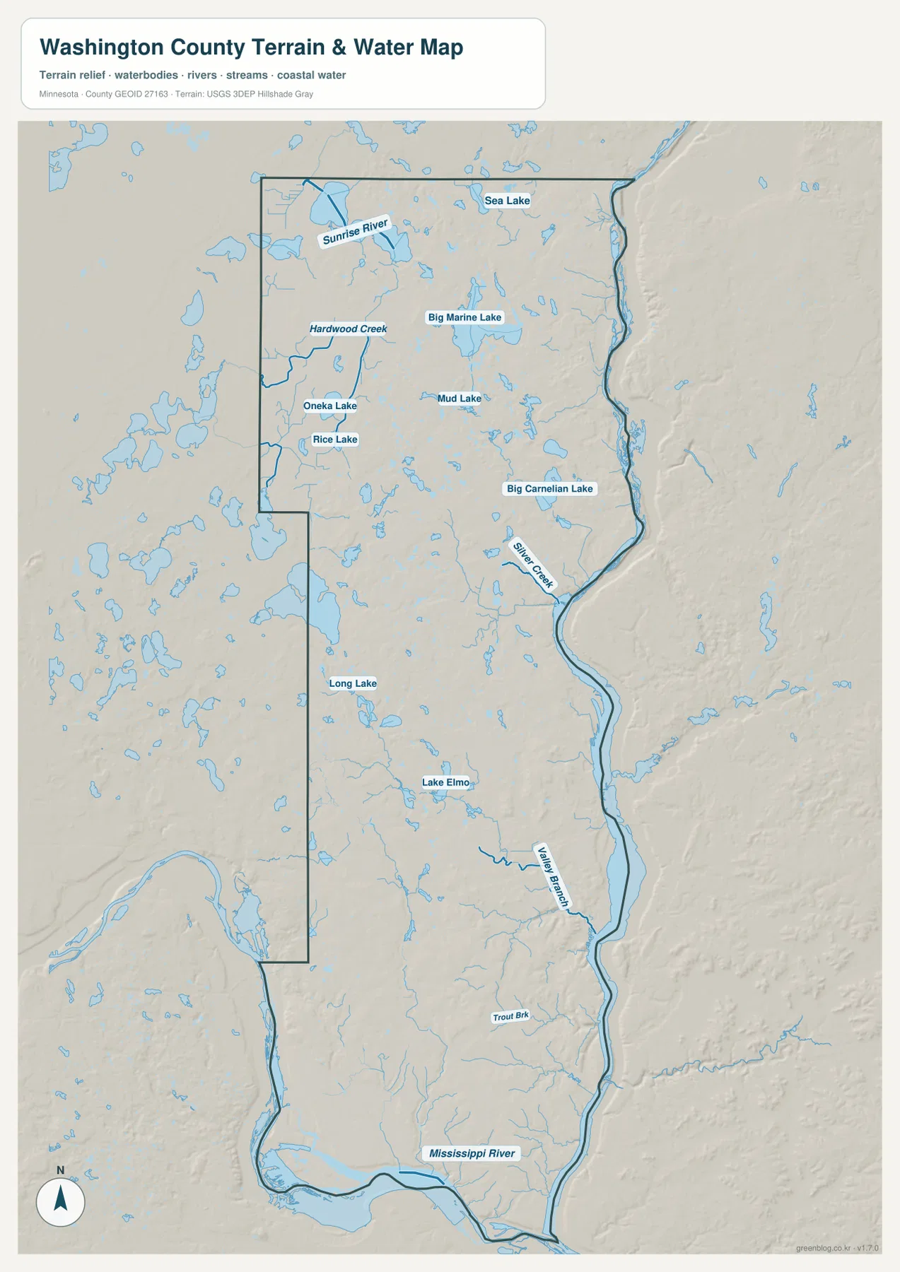
Washington County’s official Parks & Trails site provides detailed maps for places such as Big Marine Park Reserve, Lake Elmo Park Reserve, Cottage Grove Ravine Regional Park, and St. Croix Bluffs Regional Park. Those park maps are useful for trails and facilities; this county-scale water map serves a different purpose by showing how the parks, lakes, rivers, and cities sit within the broader landscape. It is not a flood-risk, water-depth, navigation, or water-quality map, so safety and property decisions require more specialized current sources.
A 194–335 meter range separates river lowlands from interior ridges
The elevation legend gives an actual county range of about 194 to 335 meters and a mean near 280 meters. The lowest green bands follow the St. Croix River along the eastern edge and the Mississippi River at the south. Moving inland, the map shifts through yellow and tan into brown ridges and uplands. The total range is only about 140 meters, but the shaded relief makes the transition from river valleys to interior high ground look sharp in several places.
The contrast is especially clear around Stillwater, where the low St. Croix corridor lies immediately beside higher inland terrain. A similar pattern appears near Afton and farther south: green lowland hugs the river, while short tributary valleys cut back into higher ground. Silver Creek and Valley Branch fit naturally into these lower corridors. The combination of water and elevation helps explain why eastern Washington County can feel much more rugged than its position on the edge of the Twin Cities might suggest.
Northern Washington County contains both relatively gentle areas near Forest Lake and Hugo and more strongly dissected terrain toward Scandia and Marine on St. Croix. Big Marine Lake and neighboring water bodies occupy lower pockets among higher ground. The south also contains a strong contrast, with low Mississippi River terrain near the bottom edge and rolling uplands farther inland around Cottage Grove and Afton. The county is therefore not characterized by one simple rise from west to east; rivers and tributaries repeatedly carve lower passages through the uplands.
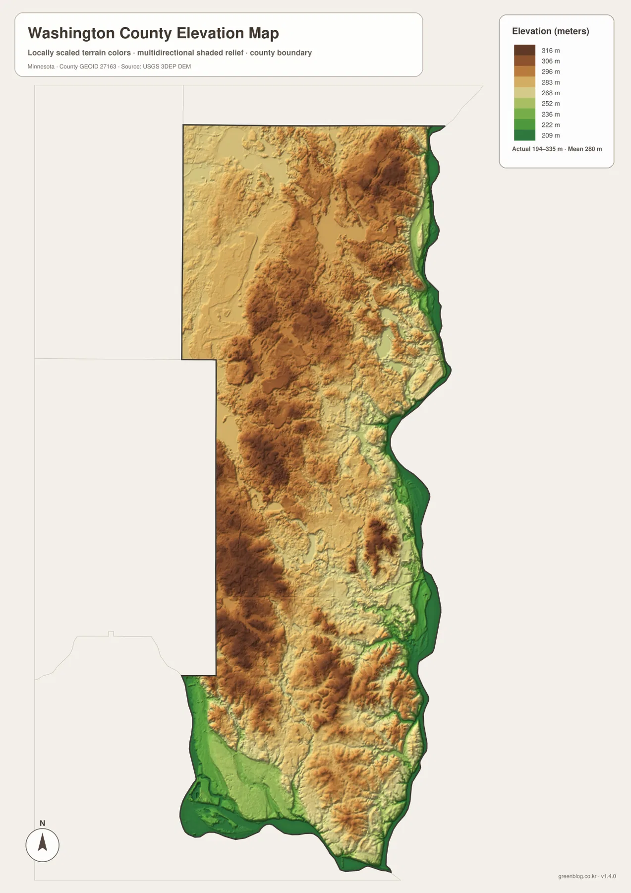
This elevation image is generalized for county-scale comparison. It should not be used to establish the exact elevation of a parcel, road grade, drainage structure, or construction site. Those uses require source elevation data, field verification, and professional surveying where appropriate. For ordinary map reading, the image is most useful for seeing why Stillwater and Afton sit beside pronounced river valleys and why the interior between Woodbury, Hugo, and Scandia contains so much rolling relief.
A useful way to combine the four Washington County views
For a first look, start with Woodbury and Stillwater. Woodbury fixes the southern urban side of the county, while Stillwater fixes the St. Croix River edge. Then add Forest Lake and Hugo in the northwest to appreciate the county’s long north–south shape. Cottage Grove and Newport complete the southern end near the Mississippi River. This sequence makes the boundary map easier to follow than trying to identify every community at once.
Next, trace the St. Croix from Marine on St. Croix through Stillwater and Afton, then move inland to Big Marine Lake, Big Carnelian Lake, Lake Elmo, Sunrise River, Hardwood Creek, and Silver Creek. When the same places are checked on the elevation map, the river valleys become low green corridors and the interior rises into tan and brown ridges. The relationship between water and relief is one of the most distinctive features of Washington County.
Use the general map when roads, municipal names, and the county boundary matter most. Use the city map to compare the six highlighted population centers without extra detail. Choose the water map for rivers, creeks, and lakes, and the elevation map for the 194–335 meter relief and the steep contrast along the St. Croix. Keeping those roles separate makes each map easier to read and avoids crowding unrelated information onto one page.
Frequently Asked Questions
Where does the St. Croix River run along Washington County?
The St. Croix River follows most of the county’s eastern side, passing the Marine on St. Croix, Stillwater, and Afton areas. On the elevation map, the river corridor appears as a long low green band beside higher inland terrain. Comparing the general and water maps is the clearest way to place the river relative to the county’s cities.
Which cities are highlighted on the Washington County city map?
The map highlights Woodbury, Cottage Grove, Oakdale, Forest Lake, Stillwater, and Hugo. Woodbury is the largest reference value in the CITY INDEX, followed by Cottage Grove and Oakdale. Forest Lake and Hugo form the northern group, while Stillwater is the eastern river city.
What does the Washington County elevation map show?
The legend reports an actual elevation range of about 194 to 335 meters and a mean near 280 meters. The lowest terrain follows the St. Croix and Mississippi river corridors, while higher rolling ground occupies much of the interior. The map is intended for broad comparison rather than survey or engineering measurements.
Map File Information
The ZIP contains the high-resolution JPG originals of the Washington County general map, city map, water map, and elevation map shown on this page.
- Included Files: 4 high-resolution JPG maps
Related Maps
Sources and references
- Minnesota Department of Transportation — Washington County Maps — road and municipal mapping references
- Washington County Parks & Trails — official county park and trail information and maps
- U.S. Census Bureau TIGER/Line Shapefiles — county boundaries and geographic reference data
- USGS National Hydrography — rivers, streams, and water features
- USGS 3D Elevation Program — elevation and terrain reference data
Green Map creates custom-edited map images using open geographic data sources such as geoBoundaries, Natural Earth, OpenStreetMap, and government open data. These maps are edited visual materials, not raw data files, and are provided for education, documents, presentations, and graphic reference.