Dunklin County occupies the southeastern Missouri Bootheel, where the land changes sharply from higher ground in the north to broad lowlands around Kennett and the long southern end of the county. Kennett is the strongest southern reference, while Malden, Campbell, and Clarkton organize the northern road network. The water layer adds the St. Francis River, Varney River, Little River, old channels, and numerous named drains. An elevation range of about 70 to 161 meters makes the northern upland stand out clearly against the flatter south. High-resolution JPG versions of the maps are available together in the download ZIP for printing, close inspection, or offline use.
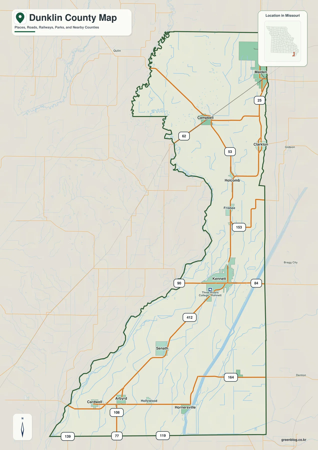
The county is broad in the north and narrows toward Arkansas. U.S. 412 crosses the Kennett area, while Routes 25, 53, 62, 84, 90, 108, 153, and 164 provide useful orientation elsewhere. The western boundary bends with rivers and lowland channels instead of following one simple straight line, and long drainage features become especially noticeable in the south. Moving between the road, water, and elevation views makes this north-south contrast much easier to understand than a single map can.
Table of Contents
Kennett anchors the southern half of the county
Kennett is the most prominent place on the general county map and sits in the southern half of Dunklin County. U.S. 412 approaches from the southwest and continues northeast, while Route 84 and Route 90 provide strong east-west reference lines near town. Three Rivers College–Kennett is labeled as well, making the urban area easy to identify. North of Kennett, the main road continues toward Holcomb and then toward the Clarkton and Campbell area.
South of Kennett, Senath is the next major city shown on the map. Cardwell, Arbyrd, and Hollywood appear near the southwestern end, while Hornersville occupies the southern east side. Routes 108, 77, 119, and 139 help distinguish the extreme south, and Route 164 runs east from the Hornersville area. These roads are useful for county-scale orientation, but the map is not a substitute for current turn-by-turn navigation or road-condition information.
Malden, Campbell, and Clarkton organize the northern road network
Malden sits close to the eastern county line in the north, Campbell lies farther southwest, and Clarkton occupies a position below both of them. Route 25 links the Malden and Clarkton side of the county, while Routes 62 and 53 are useful around Campbell. The north is easier to understand as several connected small-city areas rather than one continuous urban strip. Roads spread between them across rural land and the higher terrain visible on the elevation map.
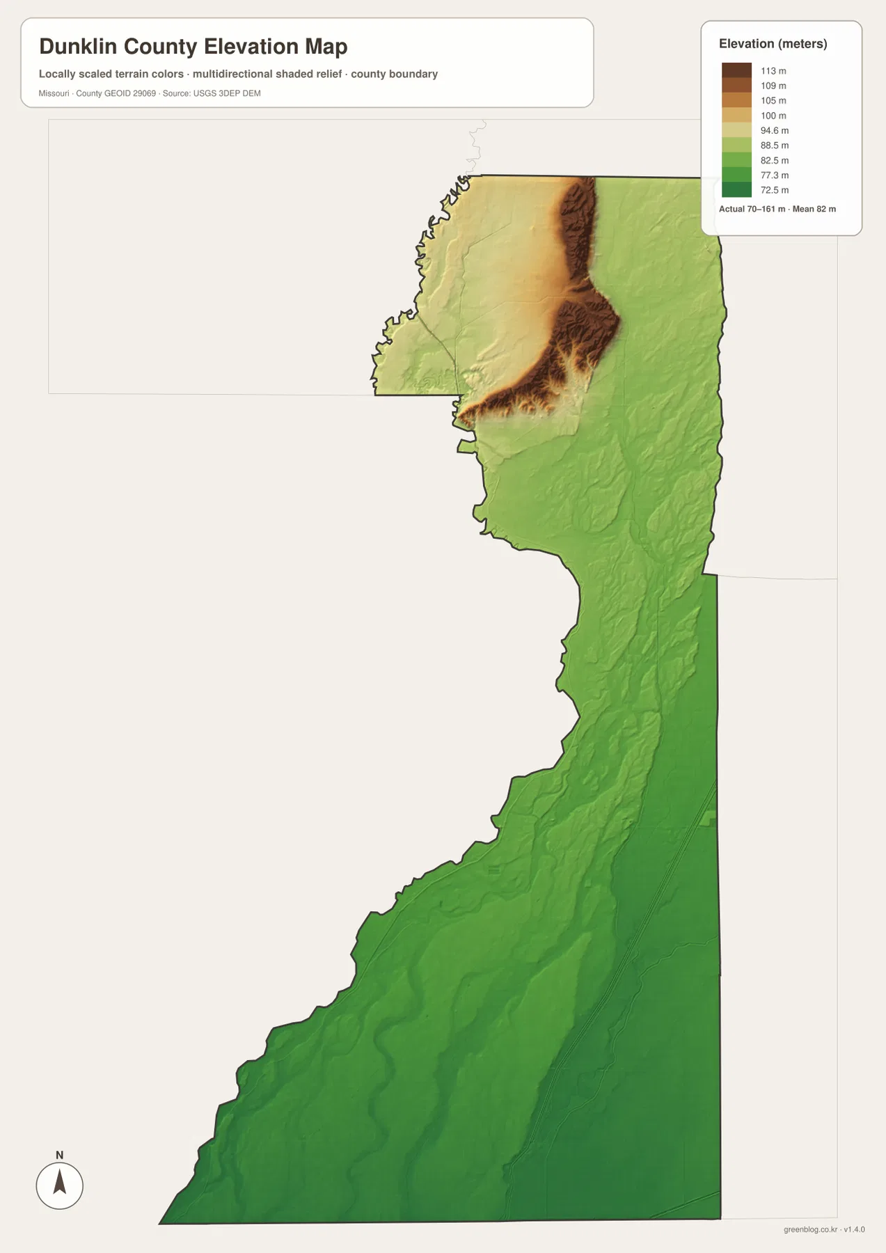
The northern elevation pattern is unusual for the Missouri Bootheel. Missouri Department of Conservation material describes a raised sandy feature called Malden Ridge extending through Malden toward Arkansas. The supplied elevation map shows a narrow band of higher brown and tan terrain in the north, surrounded by much lower green lowlands. That contrast helps explain why the Malden area looks different from the broad, flat landscape around Kennett and farther south.
Six ranked cities extend across a long north-south county
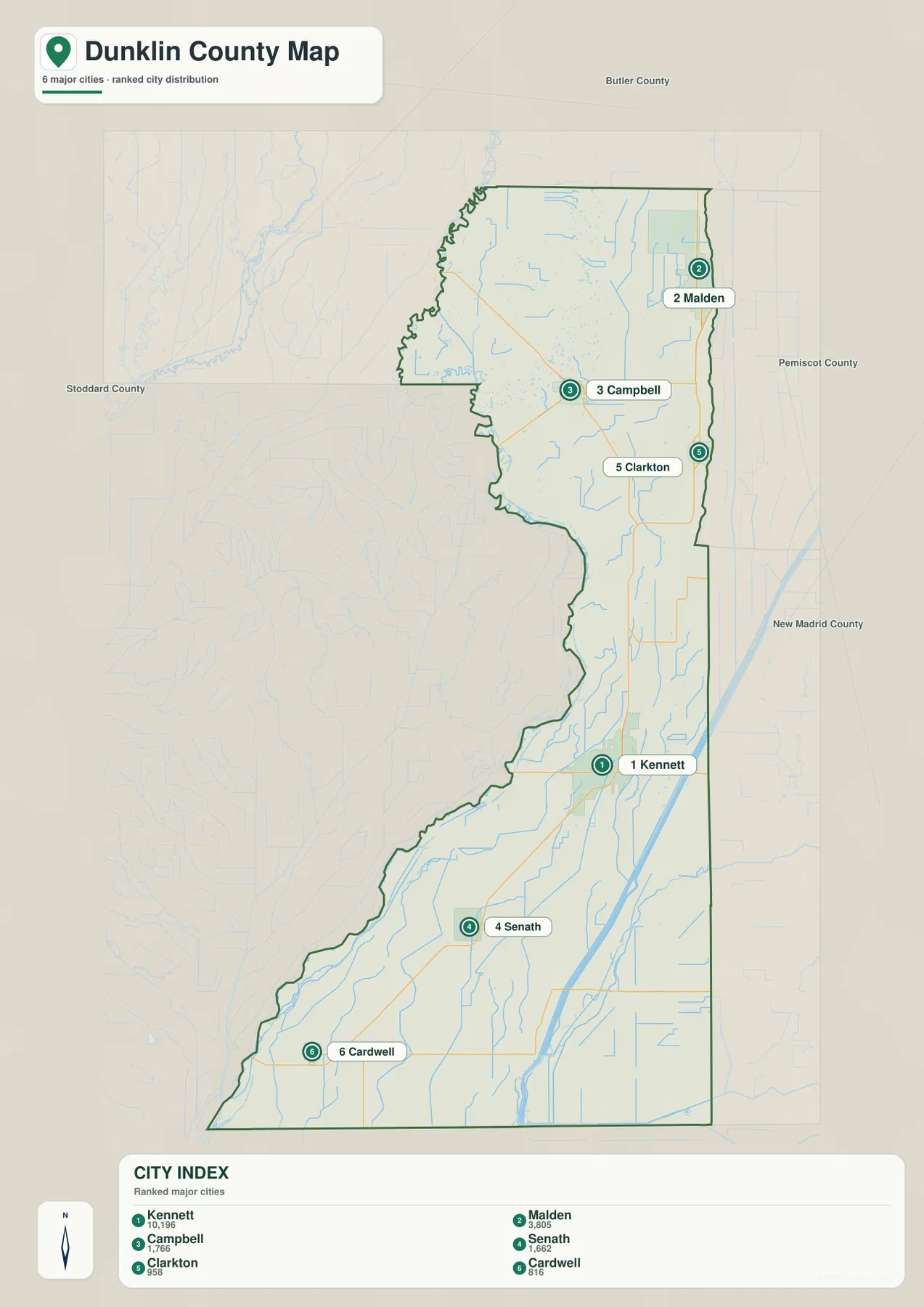
The ranked city map identifies Kennett first, Malden second, Campbell third, Senath fourth, Clarkton fifth, and Cardwell sixth. These numbers are ranking markers used by the map’s city index, not driving-distance measurements and not a substitute for current official population statistics. The distribution matters more than the numbers: Kennett sits in the southern middle, Malden is far to the northeast, and Campbell occupies a northern interior position.
Senath and Cardwell extend the settlement pattern farther south, while Clarkton fills the gap between the northern cities and the Kennett area. Because Dunklin County is unusually long, the ranked city layer is useful for seeing how far apart its major population centers are. It works best as a distribution map rather than a route planner. Readers can return to the general map whenever they need road numbers, smaller communities, or nearby county labels.
The St. Francis River helps explain the western boundary
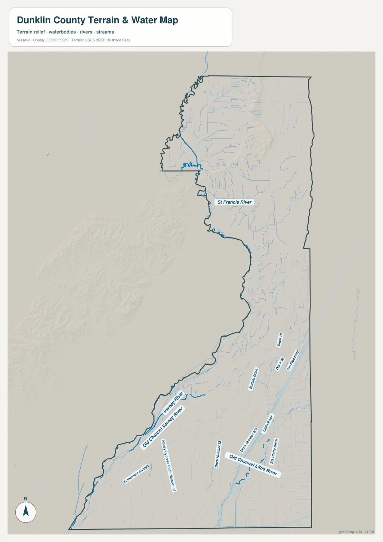
The St. Francis River is the largest named watercourse in the northern and central part of the terrain-and-water map. It enters near the northwest, bends repeatedly, and follows portions of the western side of the county. The irregular county outline makes more sense when the river is visible, because several boundary segments lie close to the winding channel. Small tributaries descend from the higher northern ground and join the broader lowlands around the St. Francis system.
The elevation layer adds an important second view. Much of the St. Francis corridor appears in lower green tones, but higher ground rises nearby in the northern part of the county. That close juxtaposition of a low river corridor and a narrow upland is one of Dunklin County’s clearest geographic features. It also distinguishes the north from the more uniformly low terrain around Kennett, Senath, and the southern Bootheel.
Varney River and old channels cross the central lowlands
Farther south, the water map labels Varney River and Old Channel Varney River. Kinnamon Slough appears in the same broad lowland region. These names show that the central and southern Bootheel landscape contains more than a few modern river lines; old channels, sloughs, and engineered drains are part of the mapped water network as well. The distinction is easiest to see on the terrain-and-water layer, where the channels can be followed separately.
This part of the county remains low on the elevation map, generally in the green end of the local scale. Long ridges like the one visible in the north are largely absent. The water map is intended as a geographic reference, not as a flood-risk, parcel-boundary, or drainage-engineering document. Anyone needing current water levels or emergency information should consult official hydrologic and local government sources.
Little River and named drains define the southern Bootheel
Little River is a major feature of the southeastern half of the water map, and Old Channel Little River is labeled separately nearby. Several named drainage features appear around the same lowland: Drain Number 35, Drain Number 19, Drain Number 239, Buffalo Ditch, Trim Foot Drain, and Holly Cypress Ditch Number 24. The abundance of named drains is one of the most distinctive features of this map and fits the extremely low, flat setting of southern Dunklin County.
These channels run through the same broad plain that contains Kennett, Senath, Hornersville, and Cardwell. On the elevation layer, most of the southern county remains green with relatively little local relief compared with the north. The general road map adds another clue: many roads and channels form long, straight or gently curving lines across the lowland. Together the maps show a landscape that is much flatter and more drainage-focused than the higher northern area.
Elevation ranges from about 70 to 161 meters
The elevation map gives an actual mapped range of roughly 70 to 161 meters, with a mean near 82 meters. Even though those numbers are modest compared with mountainous counties, the difference is visually striking. A narrow elevated zone in the north is colored tan and brown, while most of the central and southern county is green. That pattern makes the Bootheel lowlands and the higher Malden-area terrain immediately distinguishable.
The high northern ground is not one isolated peak. It forms an elongated ridge-like area that transitions quickly into lower surrounding land. South of that feature, the county becomes overwhelmingly flat, especially around Kennett and the Little River drainage. The elevation map is suitable for county-scale comparison, but it is not survey-grade data for construction, drainage design, or parcel-specific elevation decisions. Those uses require more precise official measurements.
South of Kennett, the Bootheel plain becomes even more obvious
Following the general map south from Kennett toward Senath and Cardwell, the terrain becomes visually simple but the water network becomes more complex. U.S. 412 provides the main Kennett reference, while Routes 108, 77, 119, and 139 help identify the extreme southern part of the county. Route 164 extends east in the Hornersville area. The lack of major relief does not mean the landscape is featureless; named drains and old channels provide many of the strongest local landmarks.
The water layer is especially useful here because several channels run in roughly parallel directions through the lowland. Once Senath or Hornersville is located on the road map, nearby drains can be found on the water map and then compared with the nearly uniform green elevation surface. Cardwell, at the southwestern end, provides another useful reference close to the county boundary. This approach works well in a flat landscape where hills are not available as obvious landmarks.
North and south tell two different geographic stories
Northern Dunklin County combines Malden, Campbell, and Clarkton with the St. Francis River and a narrow belt of higher terrain. The southern half is dominated by Kennett, Senath, Cardwell, Little River, and a network of old channels and drainage ditches across low ground. The county’s long shape puts these settings far enough apart that a reader can easily miss the contrast when looking only at roads.
Switching between layers solves that problem. Use the general map for city names and numbered routes, the ranked city map for the six highlighted communities, the water map for rivers and drains, and the elevation layer for the 70–161 meter contrast. Because all four maps share the same county outline, a location found in one view can be followed into the others without losing orientation.
Kennett is also the county’s administrative reference
Dunklin County’s official website lists the courthouse at 100 Kennett Court Square in Kennett. Its courthouse history page states that Dunklin County was formed in 1845 and that Kennett was selected as the county seat. That official background fits the map’s visual emphasis on Kennett as the principal southern city and a central point for county services.
University of Missouri Extension also maintains its Dunklin County office in Kennett, providing another public reference for local programs and county information. For natural-landscape context, Missouri Department of Conservation material describes Malden Ridge and other elevated sandy ridges of the Bootheel. These sources complement the map set by connecting visible places and terrain to current public information and regional geographic background.
Frequently Asked Questions
What is the easiest city to use as a reference in Dunklin County?
Kennett is the clearest starting point. U.S. 412 and Routes 84 and 90 are close by, and the city sits between the northern communities and the long southern part of the county.
Do the numbers on the city map represent driving distance?
No. They rank six highlighted cities—Kennett, Malden, Campbell, Senath, Clarkton, and Cardwell. The markers are not mileage or travel-time measurements.
What elevation range does the Dunklin County map show?
The elevation layer shows an actual range of about 70 to 161 meters, with a mean near 82 meters. Higher ground is concentrated in the north, while most of the central and southern Bootheel is much lower and flatter.
Map File Information
Download the map files associated with this page for reference, printing, and compatible visual projects.
- Included Files: Use only the versions confirmed in the article and supplied images
- File Type: Use the confirmed download contents
- Intended Use: Printing, education, presentations, and map-based projects
Related Maps
Sources and references
- Dunklin County Official Website – courthouse and county government information in Kennett
- Dunklin County Courthouse – county formation history and Kennett as county seat
- University of Missouri Extension – Dunklin County – the Kennett county office and local programs
- Missouri Department of Conservation – A Prairie in the Swamp – regional context for Malden Ridge and Bootheel sand ridges
- U.S. Census Bureau TIGER/Line Shapefiles – boundary and road data
- USGS 3D Elevation Program – elevation data
Green Map creates custom-edited map images using open geographic data sources such as geoBoundaries, Natural Earth, OpenStreetMap, and government open data. These maps are edited visual materials, not raw data files, and are provided for education, documents, presentations, and graphic reference.