Barton County lies along western Missouri, where Lamar provides the clearest central reference for a landscape of dispersed small towns, broad rural areas, numerous creek valleys, and a road network built around a few strong corridors. This Barton County Missouri Map set separates those layers so they are easier to understand: the county map shows boundaries, towns, roads, and rail lines; the city map simplifies the main population points; the water map brings the creek network forward; and the elevation map shows the contrast between lower western ground and higher terrain toward the east and southeast. High-resolution JPG versions can be downloaded from the map file box below.
The quickest way to orient yourself is to find Lamar slightly east of the county’s center. U.S. 160 crosses the county from west to east through Lamar, while I-49 and U.S. 71 form a prominent north-south corridor nearby. Liberal and Mindenmines sit well to the west, Golden City is close to the southeastern edge, and Milford appears in the northeast. Because these communities are spread in several directions rather than concentrated in one urban cluster, the maps are especially useful for seeing how roads, streams, and elevation shape the spaces between them.
Table of Contents
Lamar as the practical center of the county road picture
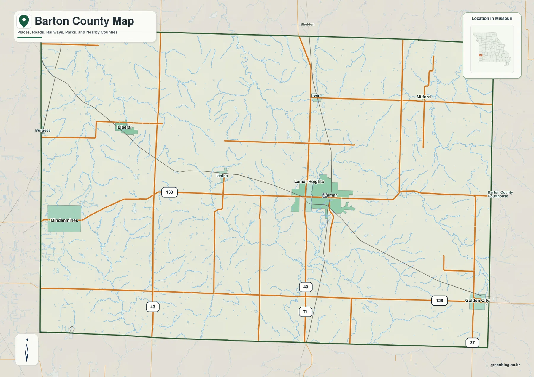
On the general county map, Lamar stands out as the strongest reference point. Its developed area is shown near the central-eastern part of Barton County, and several highways converge in the surrounding area. U.S. 160 runs east-west through the city, making it easy to trace a line toward Mindenmines in the west or toward the eastern county boundary. I-49 and U.S. 71 are labeled just south of Lamar and continue north-south, creating a second major orientation line. Starting with those two directions makes the rest of the county much easier to read.
The settlement pattern becomes more varied as you move away from Lamar. Liberal is in the northwest quadrant, Mindenmines is farther south on the western side, and Golden City sits close to the southeastern boundary. Milford appears in the northeast, while Irwin and Iantha provide smaller reference points in the north-central part of the map. Burgess is shown near the far western edge and Sheldon just beyond the northern boundary area. The result is a county where towns are separated by broad stretches of rural land, so the relationship between each place and the nearest numbered road is often more useful than a simple list of town names.
Two strong road axes: U.S. 160 east-west and I-49/U.S. 71 north-south
Barton County does not require a dense metropolitan street grid to understand its regional movement. Instead, a few long routes provide the clearest framework. U.S. 160 cuts across the middle of the county and passes directly through Lamar. The I-49/U.S. 71 corridor intersects that east-west route around the Lamar area and continues in a north-south direction. Together, those roads create a simple cross-shaped framework that can be used to locate many of the county’s smaller communities and secondary routes.
Other numbered roads add useful detail. Missouri Route 43 is labeled on the western side, Route 126 runs across the southern part of the county, and Route 37 appears near Golden City at the southeast. Several additional orange road lines connect the smaller settlements and rural areas between these numbered corridors. A diagonal rail line is also visible on the county map, giving another clue to how transportation has crossed the county. The map is best treated as a geographic reference rather than a live navigation product; current construction, closures, traffic, and turn-by-turn directions should be checked with an up-to-date transportation source.
Six indexed communities reveal how widely the towns are spaced
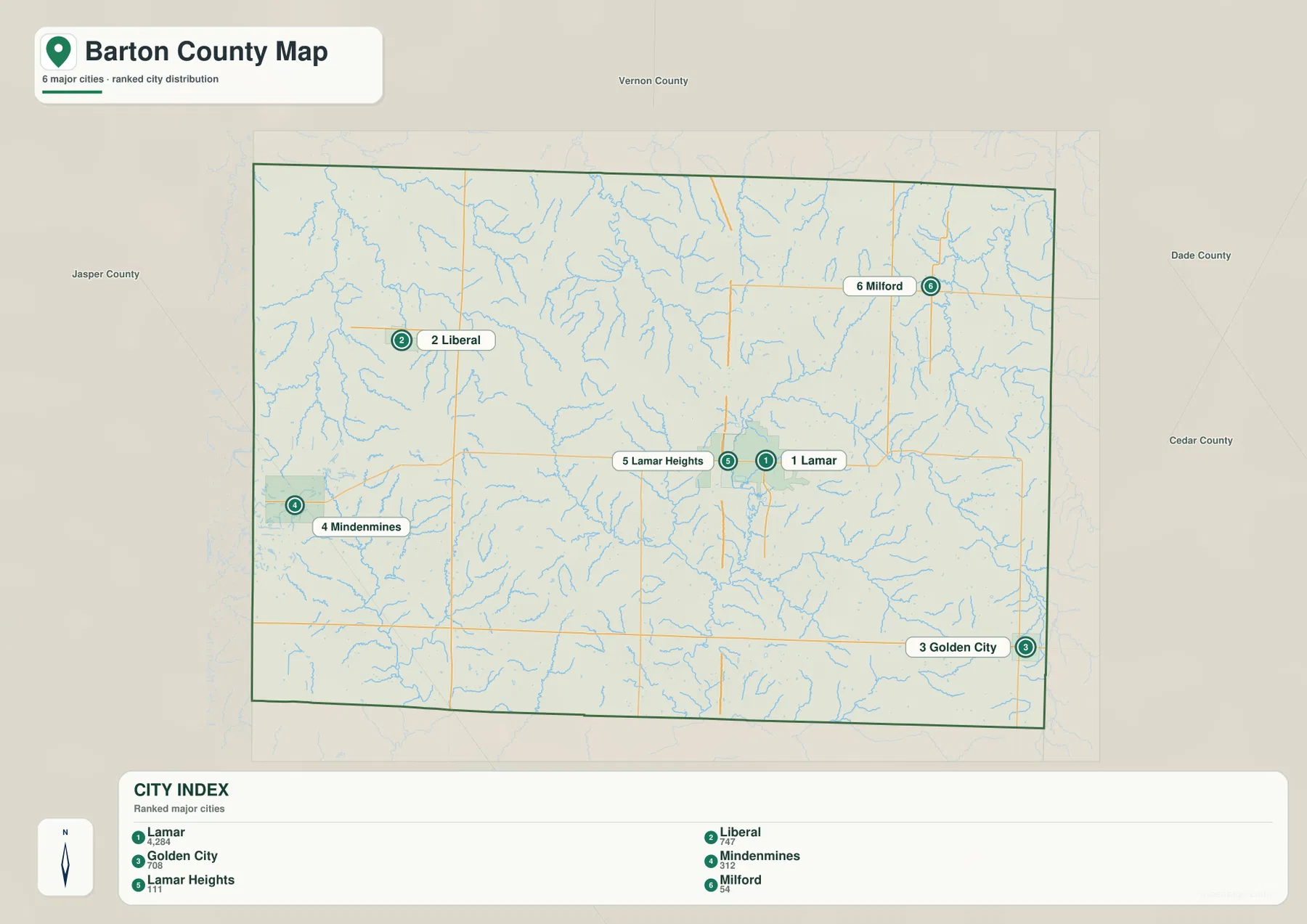
The city map strips away much of the road detail and ranks six communities so their positions can be compared quickly. Lamar is marked first, followed by Liberal, Golden City, Mindenmines, Lamar Heights, and Milford. The labels on this supplied map also include population figures, but the most valuable information for geographic reading is the spacing. Lamar and Lamar Heights are very close together near the center-east, while Liberal and Mindenmines are separated across the western side. Golden City is isolated in the southeast, and Milford provides a northeastern point that balances the pattern.
This layout shows why a countywide map is useful for Barton County. A visitor who only knows Lamar could easily underestimate the distance to Liberal or Golden City. The simplified city view makes those differences obvious because there are few competing labels. For classroom work, planning a regional graphic, or explaining where a place sits within the county, this version is cleaner than the general map. When road numbers or small settlements matter, the general county map can then be used as the second step.
Dry Wood Creek and the Spring River branches divide the rural interior
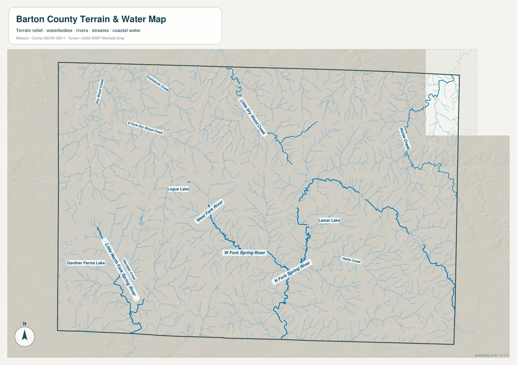
The water map changes the visual character of Barton County. Instead of the large road grid, it reveals a dense network of small tributaries that cut through the rural landscape. Dry Wood Creek and Little Dry Wood Creek are labeled in the northwest, with East Fork Dry Wood Creek and Cow Creek adding more branches in the same general area. Horse Creek appears farther east. These waterways make the northern half of the county look much more dissected than it does on a road-focused map, even though many of the channels are small.
Farther south, the Spring River system becomes the stronger reference. West Fork Spring River and North Fork Spring River are shown with heavier blue lines, and Little North Fork Spring River continues through the southwest. Lamar Lake is labeled near the center-east, Logue Lake lies farther west, and Gardner Farms Lake appears in the southwest. Pettis Creek is another named feature in the southern interior. Taken together, these labels show that Barton County is not organized around one dominant river; it is a branching landscape of creeks, forks, and small lakes that feed larger drainage systems beyond the county.
The water layer is useful for understanding relative positions, but it should not be treated as a flood map, legal water boundary, parcel survey, or boating chart. County-scale stream lines are simplified for reference, and the presence of a blue line does not by itself describe flood frequency, channel depth, public access, or navigability. For those questions, users should consult the appropriate official hydrology, property, or emergency-management records.
Higher ground toward the southeast and lower corridors along the streams
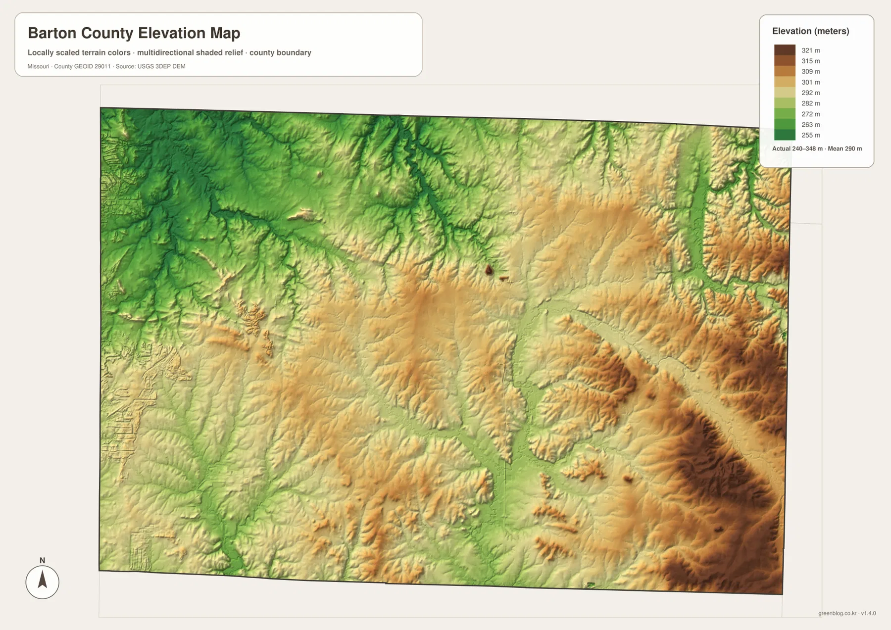
The elevation map gives a third way to interpret the same county. Its legend reports an actual elevation range of about 240 to 348 meters, with a mean near 290 meters. Greens represent relatively lower terrain, while yellows, tans, and browns mark higher areas. The broad western and northwestern side is dominated by lower colors, whereas the east and especially the southeast contain more elevated terrain. That pattern is visible even before looking at individual creek valleys.
Within the higher areas, narrow green corridors follow stream valleys and create a branching relief pattern. Comparing those corridors with the water map helps connect the North Fork and West Fork Spring River systems to lower ground carved into the uplands. The southeast includes some of the strongest brown relief, while the western side appears broader and gentler at county scale. This does not mean the west is perfectly flat or the east is uniformly high; the purpose of the map is to show relative elevation across the county, not to replace a site survey or engineering-grade elevation model.
Prairie country near Mindenmines adds context to the western map
One county-specific feature worth knowing is Prairie State Park near Mindenmines. Missouri State Parks describes it as a major surviving tallgrass prairie landscape, preserving a type of open country that once covered a much larger share of Missouri. The park itself is not the main subject of these four maps, but it provides useful environmental context for the western side of Barton County. When the general and elevation maps show broad stretches of lower, open-looking country around Liberal and Mindenmines, the prairie resource helps explain why this part of the county has a different character from the more strongly dissected southeast.
Lamar provides an equally important civic reference. Barton County’s official site centers county government resources in Lamar, and the City of Lamar history page notes that the town was laid out in 1856. Those facts help explain why Lamar appears as the strongest urban marker in the map set without turning the article into a historical profile. The geographic point is simple: Lamar is both a road junction and a major local center, while the rest of Barton County is distributed among smaller towns and wide rural spaces.
Which Barton County map works best for a specific task?
Use the general county map when roads and towns need to be seen together. It is the best choice for locating Lamar along U.S. 160, following the I-49/U.S. 71 corridor, or comparing Golden City, Liberal, Mindenmines, and Milford with the road network. Choose the city map when the goal is simply to compare the six indexed communities without the visual weight of every road and tributary. It is especially effective for a presentation or classroom page that needs clean geographic orientation.
The water map is more informative for creek names, lake locations, and the branching drainage pattern, while the elevation map explains where those valleys sit within higher and lower terrain. Looking at the two together makes the central and southern Spring River branches easier to understand. For print use, the downloadable high-resolution JPG files preserve more detail than the smaller WebP previews in the article, so labels and linework remain easier to inspect when the map is enlarged.
What becomes clearer when roads, water, and relief are compared
Barton County looks relatively simple when viewed only as an administrative outline, but the four layers reveal distinct internal regions. The Lamar area is defined by the crossing of major highways and a concentration of development. Liberal and Mindenmines occupy a more open western setting, while Golden City sits apart in the southeast. The creek network adds another level of detail, especially in places where the general map shows large rural gaps. Finally, the elevation surface shows that those gaps are not uniform: some are broad lower plains, while others contain higher uplands broken by narrow valleys.
This comparison is also a useful reminder that no single map answers every question. A road map may make a place look empty because it omits most terrain detail; a water map may make the same area look crowded because it includes many tributaries. The elevation layer can then explain why the blue lines follow certain corridors. For Barton County, the most informative reading comes from moving between these layers rather than treating any one version as a complete description of the landscape.
Frequently Asked Questions
How can I find Lamar quickly on the Barton County map?
Follow U.S. 160 across the middle of the county and look slightly east of center. Lamar is shown where that east-west route meets the major north-south I-49/U.S. 71 corridor. On the city map, Lamar is also labeled as the first of the six indexed communities, which makes it an easy reference for locating the other towns.
Which map is best for Dry Wood Creek and the Spring River branches?
The water map is the clearest choice because it labels Dry Wood Creek, Little Dry Wood Creek, West Fork Spring River, North Fork Spring River, and several lakes and smaller tributaries. Pair it with the elevation map if you also want to see how those waterways follow lower valleys through the surrounding terrain.
Can the elevation map be used for surveying or construction measurements?
No. The elevation map is a county-scale reference designed to compare higher and lower terrain. Its 240–348 meter range and shaded relief are useful for regional interpretation, but they are not a substitute for a parcel survey, engineering plan, or site-specific elevation measurement.
Map File Information
The Barton County county, city, water, and elevation maps are bundled as original high-resolution JPG files.
- File Type: JPG
Related Maps
Sources and References
- Barton County, Missouri official website – county government and local resources
- City of Lamar: History – local history and civic context
- Missouri State Parks: Prairie State Park – tallgrass prairie context near Mindenmines
- U.S. Census Bureau TIGER/Line Shapefiles – boundary and transportation reference data
- USGS National Hydrography – hydrography reference data
- USGS 3D Elevation Program – elevation reference data
Green Map creates custom-edited map images using open geographic data sources such as geoBoundaries, Natural Earth, OpenStreetMap, and government open data. These maps are edited visual materials, not raw data files, and are provided for education, documents, presentations, and graphic reference.