Yellow Medicine County stretches across southwestern Minnesota from the high country near Canby to the Minnesota River valley at Granite Falls. The county is unusually easy to understand as an east–west contrast: Granite Falls occupies low ground on the eastern side, Canby sits much higher near the western edge, and Clarkfield, Hanley Falls, Wood Lake, and Echo are spread across the broad middle and southeast. The maps on this page separate roads and settlements, city distribution, waterways, and elevation, and the high-resolution JPG originals can be downloaded together from the ZIP box below. High-resolution map files are available for download in the section below.
Relief is one of the county’s defining features. The elevation legend reports an actual range of about 234 to 530 meters with a mean near 343 meters. Brown and orange high ground dominates the far west around Canby, while dark green follows the Minnesota River valley near Granite Falls. Between those extremes, the Yellow Medicine River and its tributaries cross the county toward lower eastern terrain, linking the water map and elevation map in a particularly clear way.
Table of Contents
Granite Falls and Canby frame the county from opposite ends
Granite Falls is the easiest eastern reference on the general map. The city lies beside the Minnesota River, where the county boundary bends around the river valley. U.S. 212 appears immediately to the north near the Montevideo direction, and Minnesota 67 is marked west of Granite Falls. South of the city, Hanley Falls and Wood Lake occupy the eastern interior, while Echo sits farther southeast in the county’s lower extension.
Canby anchors the opposite side. It lies near the junction of Minnesota 68 and U.S. 75, with Porter southeast and St. Leo farther east. Long road segments cross open agricultural country between Canby and the middle of the county. Compared with the Granite Falls side, the western road pattern is more widely spaced and the settlements are farther apart, reflecting the broad rural landscape visible on the map.
Clarkfield provides a useful midpoint because it sits north of the county’s central area along Minnesota 59. Roads from the Canby side and Granite Falls side pass through or near this part of the county, making Clarkfield a natural reference for east–west orientation. Hanley Falls lies southeast of Clarkfield, Wood Lake farther east, and Echo in the southeastern extension. The towns therefore form several separate groups rather than one continuous urban corridor.
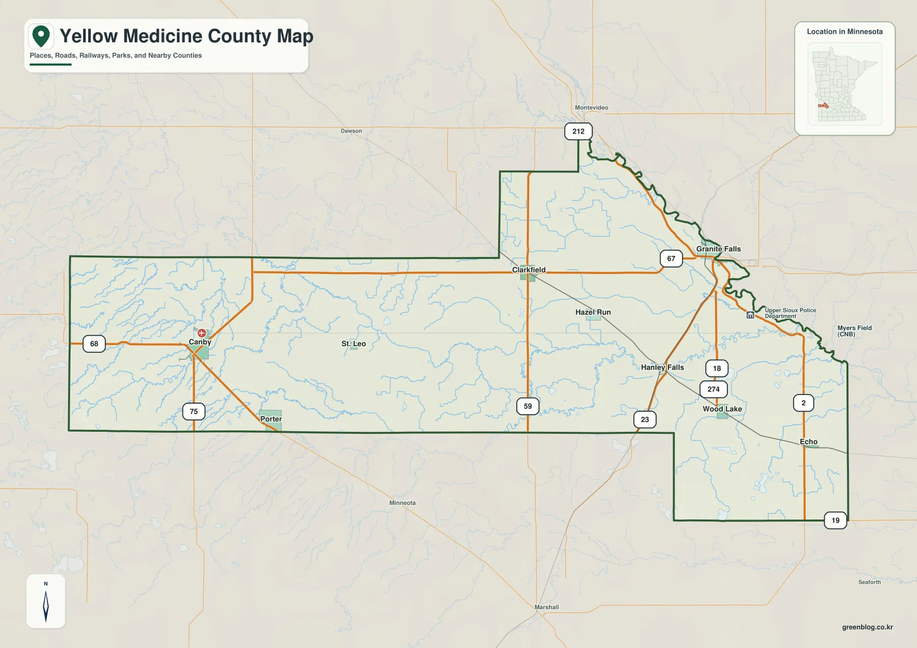
Nearby places reinforce the county’s location in southwestern Minnesota. Montevideo is shown beyond the northeastern side, Marshall lies south of the central county, and Dawson appears northwest. The eastern boundary is irregular where it follows the Minnesota River, while much of the western half is more geometric. The southeastern extension around Wood Lake and Echo gives Yellow Medicine County an outline that differs sharply from a simple rectangle.
Yellow Medicine County’s 2025 Comprehensive Plan describes the Minnesota River Valley on the east side as a distinctive river landscape with rock outcrops, while the central and western portions are strongly agricultural. That county description matches the contrast visible in the supplied maps: low river country in the east, broad open uplands in the middle, and the highest terrain toward the far west.
The city map reveals two distant anchors and a dispersed middle
The city view highlights six communities in its CITY INDEX: Granite Falls 2,685, Canby 1,556, Clarkfield 913, Wood Lake 368, Hanley Falls 248, and Echo 197. These are the reference values printed on the supplied map and work well for comparing the relative size of the highlighted places. For the latest official population figures, a current U.S. Census Bureau table should be used instead.
Granite Falls and Canby occupy almost opposite ends of the county. Granite Falls is the largest highlighted community and sits in the low eastern river country, while Canby is the second-largest and represents the western highland side. Clarkfield lies between them but farther north, making it the most useful central reference. The three positions alone reveal how long the county is from west to east.
Wood Lake, Hanley Falls, and Echo form a smaller southeastern group. Wood Lake and Hanley Falls are relatively close compared with the distance to Canby, while Echo sits farther south in the county’s lower extension. The pattern shows that Yellow Medicine County does not have one compact cluster of towns; instead, settlements are distributed across several distinct parts of the county.
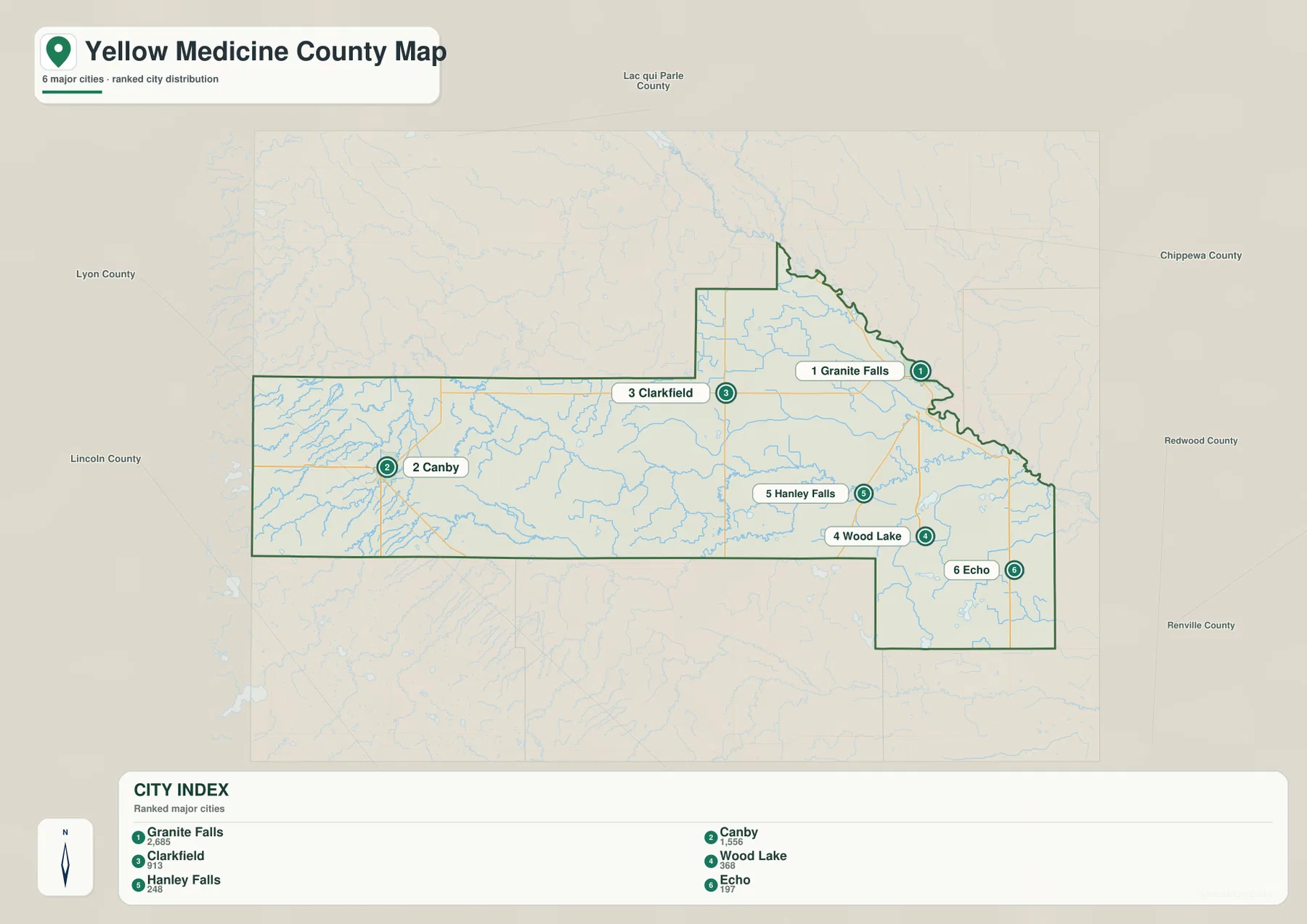
The city map is a location and ranking view, not a road-distance diagram. It does not show driving mileage between Granite Falls, Canby, and Clarkfield, and straight visual separation should not be treated as travel time. Its strength is the simplified comparison of where the six communities sit within the county and how widely they are spaced.
The Yellow Medicine River crosses the county toward the Minnesota River
The Yellow Medicine River is the most prominent interior waterway on the supplied water map. It crosses the central and eastern parts of the county and continues toward the low Minnesota River side near Granite Falls. Spring Creek feeds the system from the middle of the county, and numerous smaller channels join from both north and south. The river provides a clear geographic line through areas that otherwise look open on the road map.
Farther west, the Lac qui Parle River and Lazarus Creek form another major drainage area. The Lac qui Parle River runs through the western interior and continues northward, while Lazarus Creek enters from the west. Around Canby, many short tributaries are packed into the high terrain, creating a dense pattern of blue lines on the water map. These western channels contrast with the broad Minnesota River valley at the opposite end of the county.
Several named lakes add smaller reference points. Lanners Lake and Lake Louie lie near the central part of the county, Spellman Lake is farther south, and Wood Lake and Lone Tree Lake appear in the east. Tyson Lake, Curtis Lake, and Timm Lake are visible in the southeastern extension. No single large lake dominates the county; instead, scattered lakes and a branching stream network accompany the major rivers.
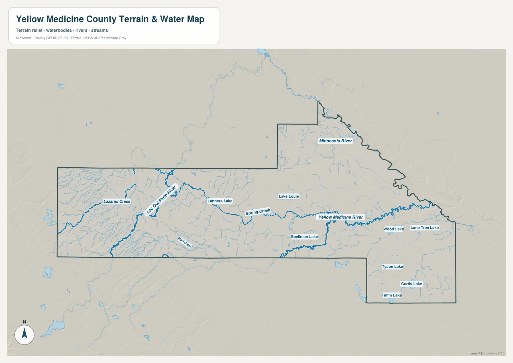
This map is designed for geographic reference, not for flood-zone, water-depth, water-quality, legal-drainage, or navigation decisions. Conditions along the Minnesota River and smaller streams can change, so specialized current sources are necessary for safety or property questions. For general orientation, a useful approach is to start at Granite Falls on the Minnesota River and trace the Yellow Medicine River westward through the center of the county.
The county’s 2025 Comprehensive Plan also identifies Oraas Park and Timm Park as county-owned parks. Timm Park shares its name with Timm Lake in the southeastern part of the water map, while Oraas Park is located along U.S. Highway 59 south of Clarkfield. Current park access, camping details, and regulations should be checked on official county resources.
Elevation drops dramatically from the Canby side to the river valley
The far western side is the most striking feature on the elevation map. Around Canby and the western county line, orange and brown colors indicate the highest terrain, with the legend reporting an actual maximum near 530 meters. Moving eastward, the colors change quickly through yellow into green, showing a substantial descent from the western uplands toward the middle of the county.
The central area is generally lower and gentler, much of it in the 300-meter range. Clarkfield and St. Leo sit below the highest Canby terrain but remain clearly above the Minnesota River lowlands. The Yellow Medicine River and smaller tributaries create subtle lower corridors through this middle section, and those channels become more noticeable as they approach the east.
Near Granite Falls, the Minnesota River valley is the lowest part of the map. The actual county minimum is about 234 meters, and dark green follows the river boundary and nearby low ground. The difference between roughly 530 meters in the west and 234 meters in the east approaches 300 meters, an unusually large countywide contrast that explains why the terrain changes so clearly across a single east–west map.
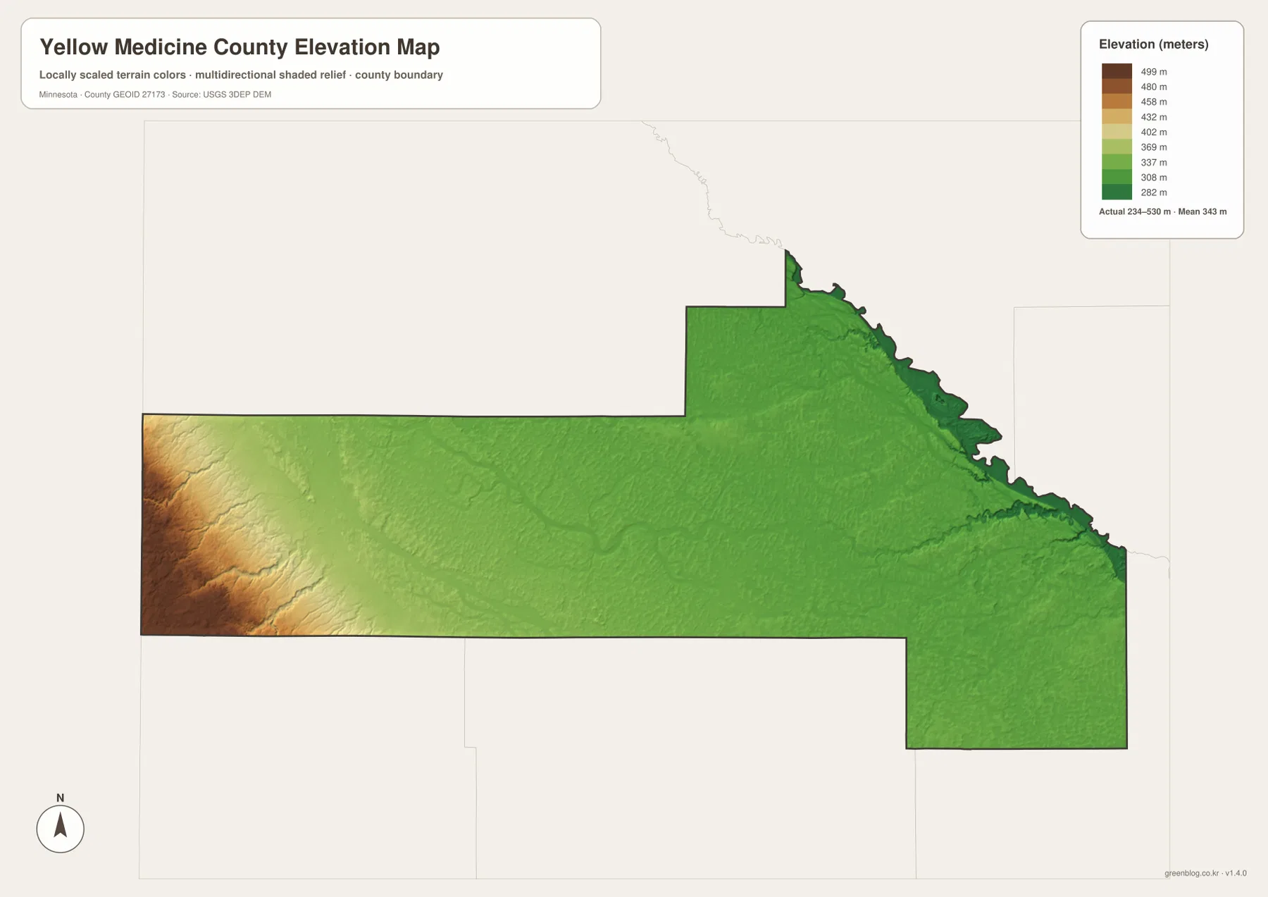
The Wood Lake and Echo area in the southeast is also relatively low compared with the Canby side, though local creeks and lakes create smaller variations. Along the northeastern Minnesota River boundary, low green terrain continues in a narrow band. The overall county trend is therefore a strong west-to-east descent overlaid by smaller valleys made by the Yellow Medicine River and its tributaries.
The elevation image is generalized for county-scale comparison. It is not survey-grade information for a farm field, building site, road grade, drainage structure, or engineering project. Those tasks require source elevation data and field verification. For ordinary readers, the map is most useful for understanding why Canby occupies high ground while Granite Falls sits in a much lower river valley.
A simple sequence for reading the county from west to east
Begin with the two ends: Canby in the west and Granite Falls in the east. Then place Clarkfield north of the middle, followed by Hanley Falls, Wood Lake, and Echo in the southeastern half. Once those six places are familiar, the long shape of Yellow Medicine County becomes much easier to follow on the road map.
Next, use the water map to trace the Yellow Medicine River toward the Minnesota River. Compare the Lac qui Parle River and Lazarus Creek in the west, Spring Creek in the center, and the smaller lakes near Wood Lake and Echo. When the same locations are checked against the elevation map, the county’s strongest geographic relationship becomes clear: water flows out of high western and central ground toward much lower eastern valleys.
Use the general map when roads, county boundaries, and town locations are the priority. The city map simplifies the six highlighted communities, the water map isolates rivers and lakes, and the elevation map shows the 234–530 meter relief. Choosing the view that matches the task keeps the information clear for printing, classwork, presentations, or personal reference.
Frequently Asked Questions
Why is the Canby side much higher than Granite Falls?
The elevation map places the highest terrain near Canby and the western county line, while Granite Falls sits in the low Minnesota River valley. The legend reports an actual range of about 234 to 530 meters, so the west-to-east difference is close to 300 meters.
Where does the Yellow Medicine River cross the county?
The Yellow Medicine River runs through the central and eastern parts of the county toward the Minnesota River side near Granite Falls. Spring Creek and many smaller tributaries join it along the way, making it the most prominent interior river on the supplied water map.
Which communities are highlighted on the city map?
The city map highlights Granite Falls, Canby, Clarkfield, Wood Lake, Hanley Falls, and Echo. Granite Falls has the largest reference value in the CITY INDEX, with Canby second and Clarkfield third. The values are map references rather than a substitute for the latest official Census table.
Map File Information
The ZIP contains the high-resolution JPG originals of the Yellow Medicine County general map, city map, water map, and elevation map shown on this page.
- Included Files: 4 high-resolution JPG maps
Related Maps
Sources and references
- Yellow Medicine County official website — county and local information
- Yellow Medicine County Comprehensive Plan 2025 — county landscapes, parks, agriculture and natural resources
- U.S. Census Bureau TIGER/Line Shapefiles — county boundaries and geographic reference data
- USGS National Hydrography — rivers, streams, and water features
- USGS 3D Elevation Program — elevation and terrain reference data
Green Map creates custom-edited map images using open geographic data sources such as geoBoundaries, Natural Earth, OpenStreetMap, and government open data. These maps are edited visual materials, not raw data files, and are provided for education, documents, presentations, and graphic reference.