Hamilton County sits along the Georgia line in north Florida, and its map becomes much easier to understand once three places are fixed in mind: Jasper near the center, Jennings to the north, and White Springs in the southeast. The county is not organized around a large urban area. Instead, long rural stretches separate the municipalities, while major highways and rivers provide the clearest reference points. The maps on this page show those relationships, and the matching high-resolution JPG files can be downloaded together in a ZIP from the map file box below.
The county outline itself tells part of the story. Georgia forms the northern state boundary, but much of the western, southern, and eastern edge follows winding river corridors rather than straight survey lines. That makes the Suwannee and Withlacoochee rivers useful for orientation, while Jasper and the road network provide a practical center for locating towns and travel routes. Reading the boundary, roads, and waterways together gives a more accurate picture than treating the county as a simple block on a statewide map.
The supplied set includes a county map with places and roads, a simplified city-connections map centered on Jasper, and a terrain-and-water map that emphasizes rivers, streams, ponds, and the shape of the county. They are not interchangeable. One is best for the overall road-and-boundary picture, another makes the three incorporated places easier to compare, and the water map is more useful when a location is described by a river or small body of water rather than by a town.
Table of Contents
Start with Jasper before following the county outward
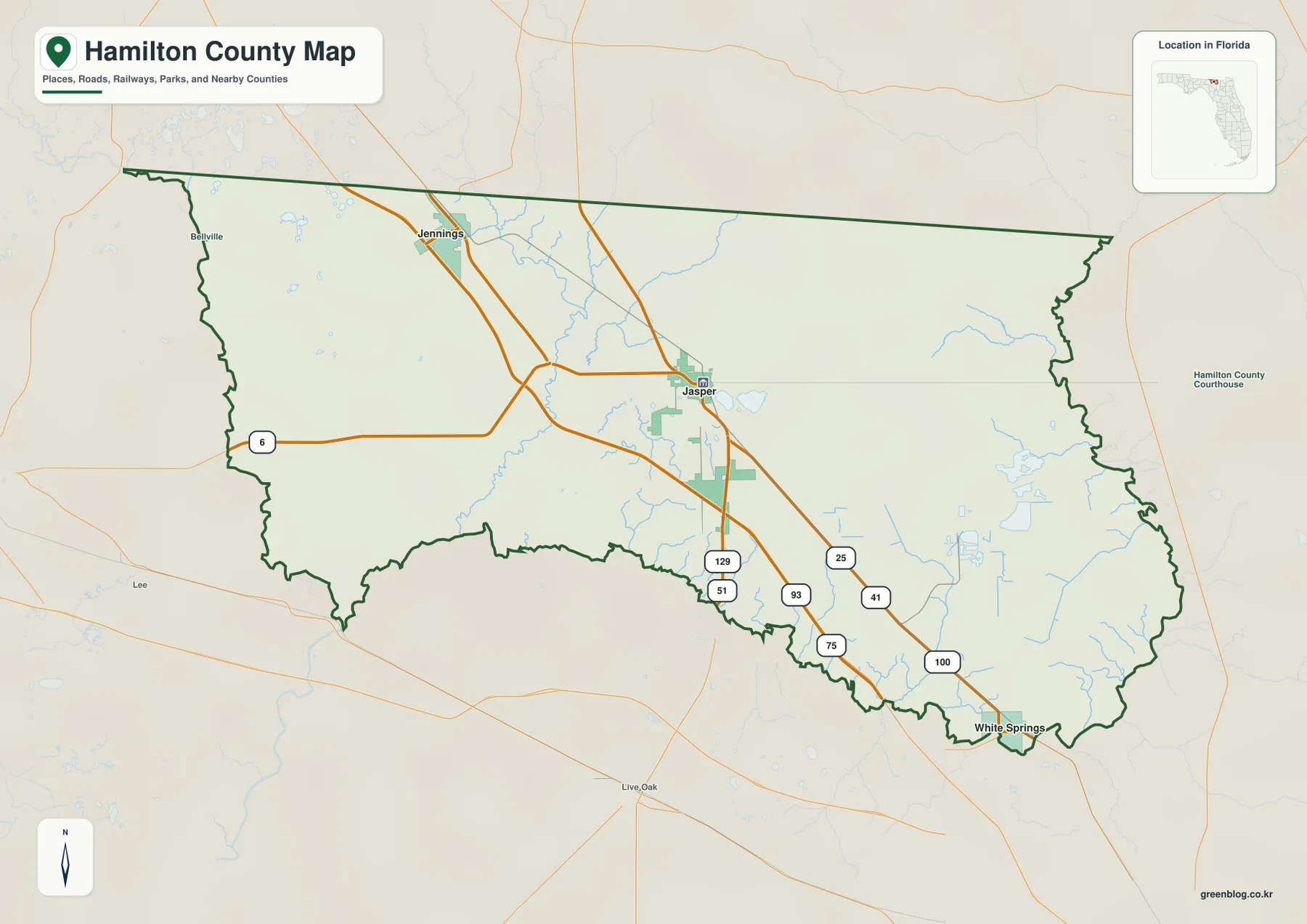
Jasper is the county seat and the most useful anchor on the general map. It lies close to the middle of Hamilton County, with several numbered roads meeting or passing nearby. Jennings appears well to the north, close to the Georgia side of the county, while White Springs sits far to the southeast near the Suwannee River. If those three places are located first, the broad rural areas between them make more sense and smaller road or water labels are easier to place.
Hamilton County also has an important two-state context. The current county materials identify Madison, Suwannee, and Columbia counties on the Florida side and Brooks, Lowndes, and Echols counties across the Georgia side. The entire northern edge is a state line, but the Georgia county on the other side changes as you move from west to east. That distinction matters when a map is being used for regional reference rather than only for travel inside Hamilton County.
Large portions of the map contain no incorporated-town label, and that is normal for this county. Rural roads, river bends, small communities, and local water features become more useful than a distant city name once a location is outside Jasper, Jennings, or White Springs. For a rural address, it is often better to note the nearest numbered road and the side of a river together with the closest municipality instead of assuming that the municipality marks the exact destination.
I-75 and U.S. 41 create two different north-south reference lines
I-75 is the dominant long-distance highway on the map, entering from Georgia and running south through the western side of the county. It does not pass through the center of Jasper. U.S. 41 follows a different pattern and is especially useful for understanding the relationship among Jennings, Jasper, and White Springs. Because both roads generally trend north and south, a quick glance can make them seem interchangeable, but they lead a reader to different parts of the county.
The county map also shows other numbered routes around Jasper, including 6, 129, 41, and 100. These roads help explain how travel spreads away from the county seat toward the western, southern, eastern, and northern parts of Hamilton County. A destination described only as “near Jasper” can therefore fall on very different sides of town. Checking the route number alongside the place name is a simple way to avoid placing a rural site on the wrong corridor.
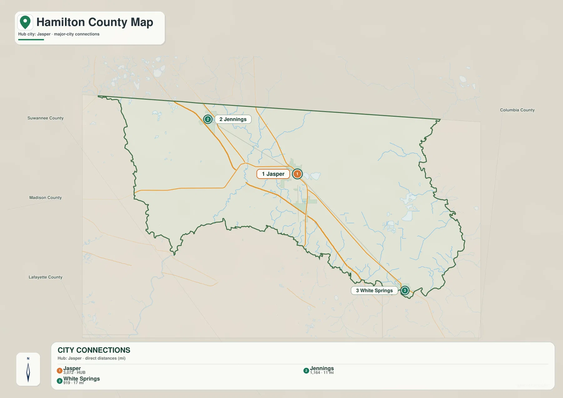
The city-connections map strips away much of the extra detail and focuses on the three incorporated places. It shows Jennings about 11 miles from Jasper and White Springs about 17 miles from Jasper. Those are direct, straight-line distances rather than driving distances. Actual road travel is longer or shorter depending on the chosen route, intersections, and river crossings, so the mileage should be used to compare relative position rather than to estimate a trip time.
This simplified view is especially helpful when the question is directional: Which town is north of Jasper? Which one is closer to the Suwannee side of the county? Where does Jasper sit between the two? For detailed routing, however, return to the county map or a current navigation service. The city map deliberately removes smaller road and water labels so the three-town arrangement remains easy to see.
Rivers explain the winding southern, eastern, and western edges
The Suwannee River is the most prominent water feature on the eastern and southern side of Hamilton County, while the Withlacoochee River follows a long portion of the west. Inside the county, the Alapaha River and Little Alapaha River run south from the Georgia side and join the larger drainage system. The result is a county whose boundary is closely tied to water. On the map, many of the bends that might otherwise look like arbitrary linework are actually following river corridors.
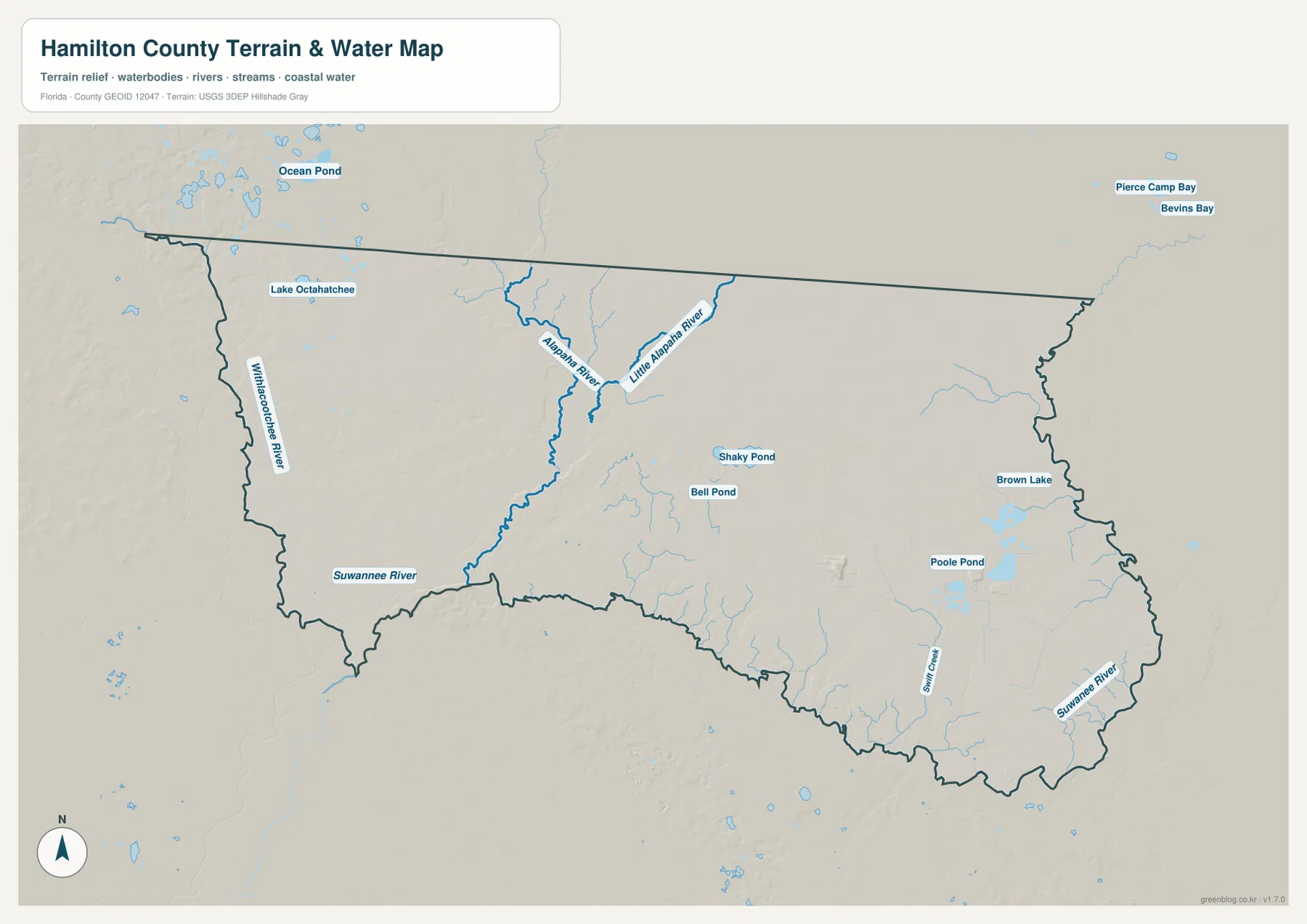
The water map also labels smaller features such as Shaky Pond, Bell Pond, Poole Pond, and Brown Lake. These are useful local references in parts of the county where the municipal names are far away. They should not be interpreted as equivalent to the major rivers, and a named pond on this map does not imply public access. The main value of the layer is geographic orientation: it helps connect an otherwise sparse rural area to a recognizable water feature.
River boundaries also affect practical distance. A location on the opposite bank can appear very close in a straight line but still require a significant road detour to reach a bridge. This is particularly important around the Suwannee and Withlacoochee edges. When using a printed copy for a route note, mark the intended river crossing as well as the destination. The water map is a reference map, not a navigation chart, flood-risk map, or legal survey of riparian property.
The Alapaha provides a different kind of reference because it runs through the interior rather than simply tracing the county edge. It helps separate central and western rural areas and connects the northern Georgia-side drainage to the Suwannee system farther south. A blue line inside the boundary should therefore not automatically be read as a county line. The dark county outline and the river labels need to be considered together.
White Springs ties the southeastern road network to the Suwannee corridor
White Springs is a useful southeastern reference because U.S. 41 approaches the town as the county narrows toward the Suwannee River. On the city map it is clearly southeast of Jasper, and on the water map the surrounding river and tributary network becomes much more obvious. A reader looking only at the city map can locate the town, but the county and water maps are better for understanding why nearby destinations may depend on a particular road or river crossing.
The existing verified county material also distinguishes Stephen Foster Folk Culture Center State Park from Big Shoals State Park. Both are associated with the White Springs area, but they are not one location. Stephen Foster is close to the town and U.S. 41, while Big Shoals lies upstream and is reached by separate access roads. A shared White Springs mailing reference should not be used to collapse those destinations into a single point on a working map.
For a trip or field note, the most reliable sequence is to locate White Springs first, identify the relevant highway and river side, and then check the official destination page for the current entrance. Static map files are excellent for the regional picture, but park access, river levels, closures, and construction can change. Keeping that distinction clear prevents a general county map from being treated as a live operations map.
Choose the map by the question you need to answer
Use the general county map when the task involves the county boundary, the Georgia line, Jasper, major roads, or the relative position of several features at once. It gives the broadest context and makes it easy to see that I-75 stays west of Jasper while U.S. 41 continues through the local town sequence. It is also the most useful base when a report or handout needs both a county outline and recognizable transportation references.
Use the city-connections map when the main point is simply to compare Jasper, Jennings, and White Springs. Its direct-distance labels make relative spacing easy to grasp, and the lighter level of detail keeps the three places from getting lost among water and road symbols. Because those distances are straight-line measurements, this map is best for orientation rather than turn-by-turn travel planning.
Use the terrain-and-water map when rivers, ponds, or the curved county edge matter more than the road network. It shows how the Suwannee and Withlacoochee define major parts of the perimeter and how the Alapaha system runs through the interior. For flood status, current river stage, boating conditions, parcel boundaries, or legal land questions, move from this overview to the appropriate official source instead of trying to extract a decision from the static image.
Frequently Asked Questions
Are the 11-mile and 17-mile labels on the city map driving distances?
No. The city-connections map uses direct, straight-line distances from Jasper to Jennings and White Springs. Road mileage can be different because a trip follows actual highways, intersections, and river crossings. Use the labels to compare the relative spacing of the towns, not to predict travel time.
Do I-75 and U.S. 41 pass through the same parts of Hamilton County?
No. I-75 runs west of Jasper and serves long-distance north-south travel. U.S. 41 is the clearer local reference for the sequence from Jennings through Jasper toward White Springs. Treating the two routes as the same corridor can place Jasper or a local destination too far west on a working map.
Can the terrain-and-water map be used to determine flood risk or boating conditions?
No. It is a geographic reference showing the location of rivers, streams, ponds, and the county outline. Flood risk, current river stage, boating access, and legal shoreline questions require current information from the responsible water, emergency, or land-management agency.
Map File Information
Download the high-resolution JPG versions of the Hamilton County maps used on this page. The ZIP contains three A3 JPG files: the county map, the city-connections map, and the terrain-and-water map.
- Included Files: County map, city-connections map, terrain-and-water map
- File Type: ZIP containing three high-resolution A3 JPG files
Related Maps
- Arcadia Roads and Peace River | DeSoto County Florida Map
- Baker County Florida Map
- Blountstown, SR 20, and the Apalachicola River | Calhoun County Florida Map
Sources
- Hamilton County official website
- U.S. Census Bureau 2024 County Adjacency File
- Florida Department of Transportation county highway maps
- Suwannee River Water Management District
- Hamilton County Tourist Development Council communities
- Stephen Foster Folk Culture Center State Park
Green Map creates custom-edited map images using open geographic data sources such as geoBoundaries, Natural Earth, OpenStreetMap, and government open data. These maps are edited visual materials, not raw data files, and are provided for education, documents, presentations, and graphic reference.