Pipestone County occupies the far southwestern part of Minnesota, with the city of Pipestone as the main settlement and a noticeably higher upland rising toward the northeast. Edgerton sits in the southeast, Ruthton is far to the northeast, and Holland, Woodstock, and Ihlen are spread across the interior and southern half. The water map adds another layer: Pipestone Creek, Rock River, Flandreau Creek, and the headwaters of the Redwood River move through different parts of the county rather than forming one simple drainage corridor. This guide explains the county, city, water, and elevation maps together, and the four matching high-resolution JPG files can be downloaded in one ZIP. High-resolution map files are available for download in the section below.
The city of Pipestone is the easiest reference point for reading the county. U.S. 75 passes north–south through town, while Minnesota 30 and Minnesota 23 provide important regional connections. National Park Service directions for Pipestone National Monument also identify these highways as the main approaches to the city. From Pipestone, the road network spreads toward Edgerton and Woodstock in the east, Ihlen in the southwest, and Holland and Ruthton farther northeast, giving the county a broad rural pattern rather than a single continuous urban corridor.
Table of Contents
Pipestone as the Junction of U.S. 75 and the County Road Grid
The county overview shows Pipestone as the strongest road junction and the largest built-up area. U.S. 75 runs through the city, while Minnesota 30 provides an east–west reference. Ihlen lies southwest of Pipestone, Trosky and Edgerton are farther southeast, and Woodstock sits near the eastern side. Holland is northeast of Pipestone and Ruthton occupies the far northeastern corner, making the distances between communities an important part of the county’s geography.
Straight rural roads form a large grid across much of Pipestone County, especially away from stream valleys. Near creeks and rolling ground, some routes bend or break the pattern. The map also marks Minnesota West Community and Technical College near Pipestone and shows several smaller places that do not appear in the six-city ranking. This mix makes the county easy to navigate at a broad scale even though the communities themselves are widely separated.
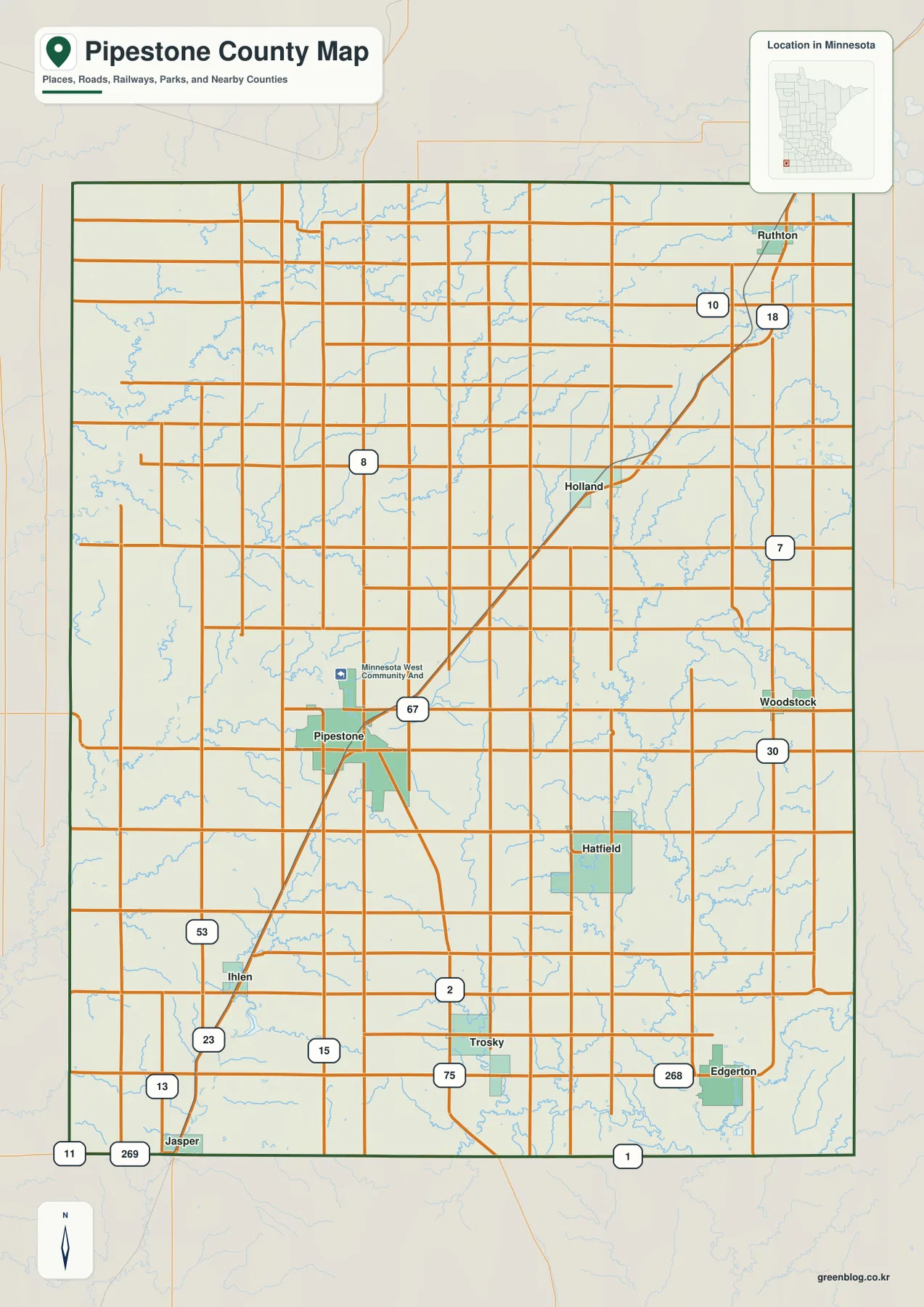
The county is bordered by Lincoln County to the north, Murray and Nobles counties to the east, and Rock County to the south, while South Dakota lies just beyond the western side of the region. The boundary is mostly composed of long straight survey lines. The overview is intended for general location and road context, not parcel ownership, zoning, or legal survey decisions.
Six Communities Spread from Ihlen to Ruthton
The ranked city distribution map highlights six communities. Its index lists Pipestone at 4,129, Edgerton at 1,104, Holland at 292, Ruthton at 222, Woodstock at 200, and Ihlen at 91. Pipestone is clearly the largest entry, with Edgerton second, but the geographic spacing matters just as much as the ranking. The remaining communities are spread from the southwest to the far northeast rather than clustered around the county seat.
From Pipestone, Edgerton lies southeast and Ihlen southwest. Holland is northeast of the main city, Woodstock is east of the center, and Ruthton sits much farther northeast. The simplified city map removes most road detail, making those directions and distances easier to compare. The index values should be treated as the figures supplied with this map; current official population estimates should be checked against the latest U.S. Census Bureau data when needed.
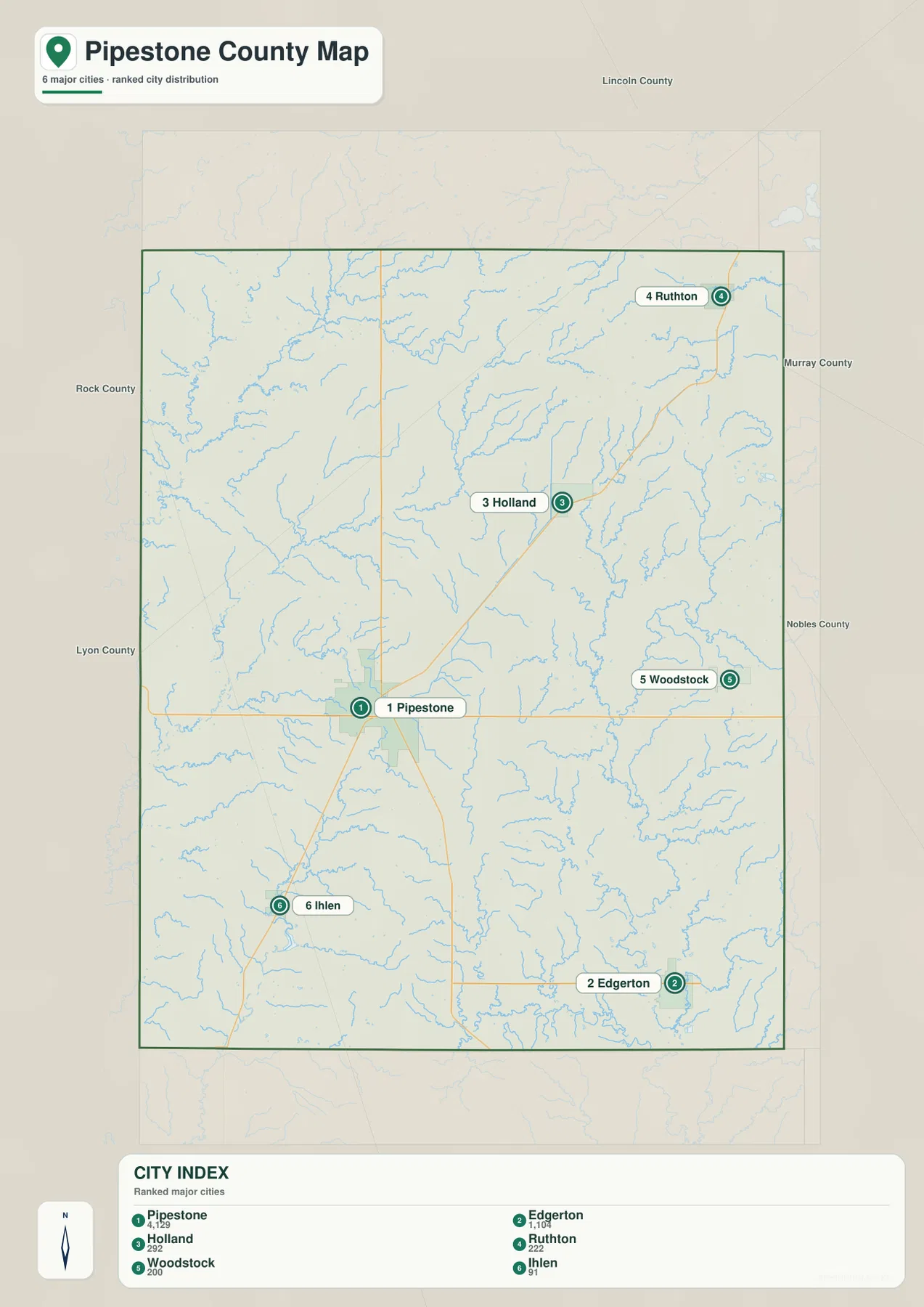
The surrounding county labels add regional context. Lincoln County is north, Murray and Nobles counties lie east, and Rock County is south. Pipestone County’s western location also places it close to the South Dakota line. For smaller places such as Trosky and for detailed highway connections, the full county overview is a better companion to the ranked city map.
Pipestone Creek, Rock River, and Several Separate Drainage Areas
Pipestone Creek is one of the defining waterways in the western and central part of the county. The main channel is joined by North Branch Pipestone Creek and South Branch Pipestone Creek, while Indian Lake sits nearby as a small water landmark. The pattern is a network of branching streams rather than one dominant river, and it follows shallow valleys that become much clearer on the terrain and elevation maps.
The northwestern side contains Flandreau Creek and East Branch Flandreau Creek, while the northeastern edge includes the upper Redwood River. These streams move through different drainage areas, showing that the county does not simply slope toward one single basin. Numerous smaller tributaries fill the spaces between the named channels, especially across the northern half.
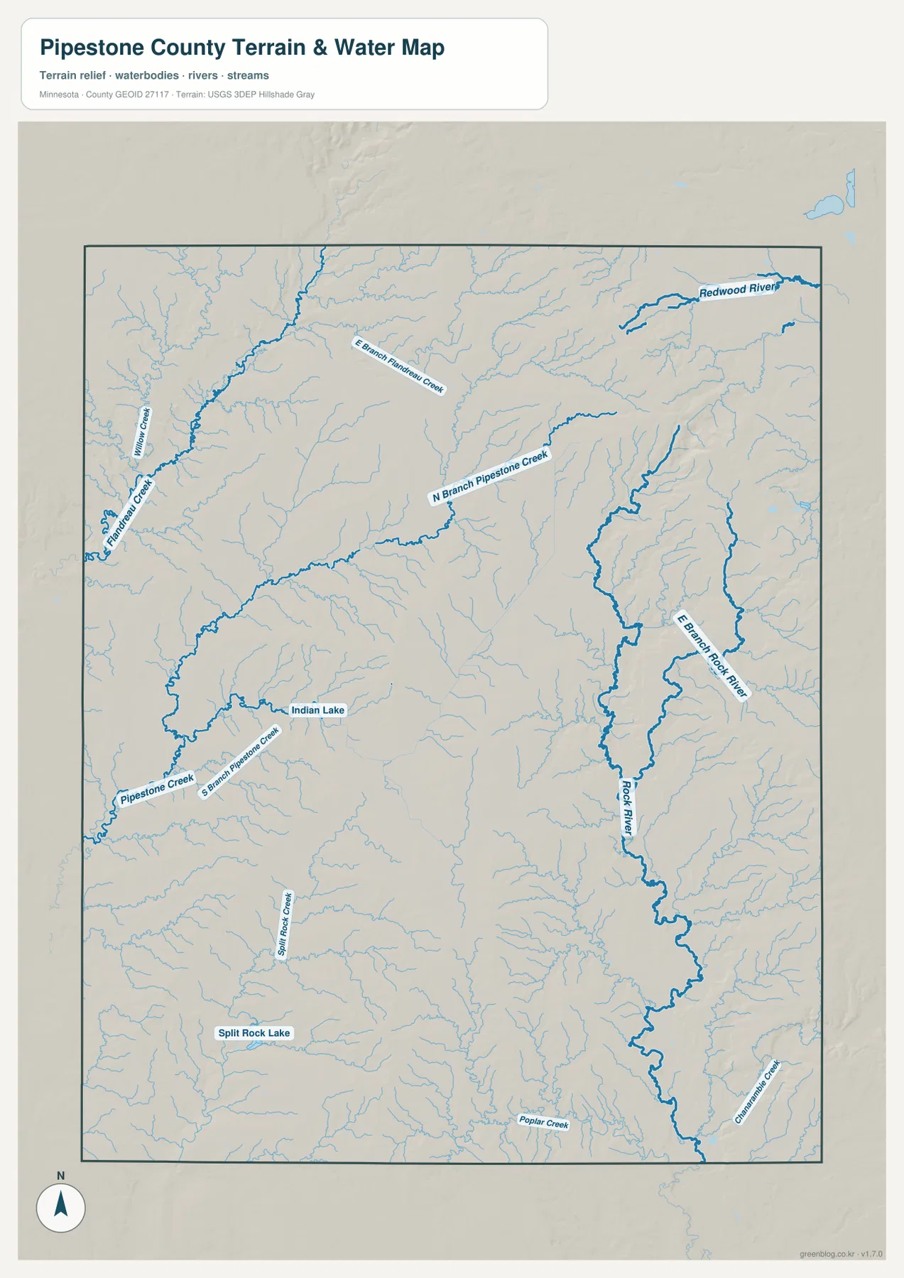
On the eastern side, Rock River and East Branch Rock River form a long north–south system. Small tributaries around Woodstock and Edgerton feed this side of the county, while Chanarambie Creek and Poplar Creek appear farther south. Split Rock Creek and Split Rock Lake provide another southern reference. Taken together, the map shows several distinct drainage areas: Pipestone Creek in the west and center, Rock River in the east, Flandreau Creek in the northwest, and the Redwood River headwaters in the northeast.
The water layer is intended for geographic reference rather than flood-risk, navigation, depth, drainage-rights, shoreline-ownership, or legal-access decisions. Anyone using a stream, lake, or agricultural drainage feature for planning should consult current USGS, state, county, and property-specific information instead of relying on the map alone.
High Northeastern Prairie above Lower Western and Southeastern Valleys
The elevation map shows a major contrast between the high northeastern upland and the lower western and southeastern parts of Pipestone County. Its legend gives an actual range of about 468 to 608 meters and a mean near 524 meters. Browns and dark oranges dominate the northeast, while greens become more common toward the west and southeast. The difference is large enough to stand out immediately even though the county is part of an agricultural prairie region.
The northeastern high ground contains long ridges and branching valleys rather than one smooth plateau. National Park Service information for Pipestone National Monument describes the local landscape as part of the Coteau des Prairies, or Highland of the Prairies, and notes the area’s distinctive geological and glacial setting. That broader regional context fits the strong upland relief visible on the county map, especially in the northeast.
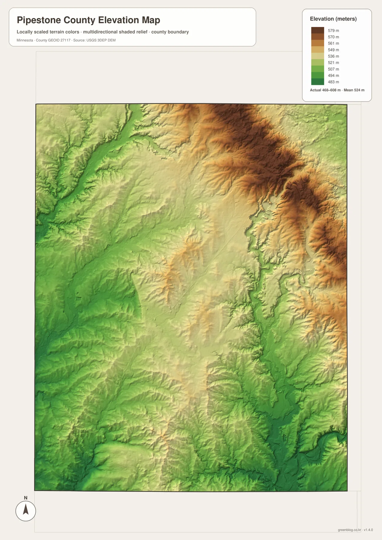
Lower corridors cut through the county along several streams. Flandreau Creek occupies a greener valley in the northwest, and the Rock River system forms a long lower channel through the eastern half. Around Pipestone, the surface is closer to the middle of the county’s elevation range, while Edgerton and parts of the southeast are notably lower than the northeastern ridge country.
The colors are scaled specifically to show variation inside Pipestone County, so the same green or brown shade on another county map may represent a different absolute elevation. The shaded surface is intended for broad geographic interpretation rather than survey-grade measurement. Engineering, construction, drainage design, and legal elevation work require more precise source data or field measurements.
Choosing the Best View for Roads, Streams, and Relief
For roads and settlement orientation, begin with the county overview. U.S. 75 and Minnesota 30 make it easy to locate Pipestone first, then place Edgerton, Woodstock, Holland, Ruthton, and Ihlen around it. The ranked city map is more efficient when the main question is simply how the six highlighted communities compare in size and direction.
For natural geography, start with Pipestone Creek and its branches, then compare the Flandreau Creek system in the northwest with Rock River in the east and the Redwood River headwaters in the northeast. The elevation map explains the larger setting by showing high northeastern ground above lower western and southeastern valleys. Using the water and elevation views together makes the county’s drainage pattern much easier to understand.
The WebP previews on the page are optimized for quick viewing. The downloadable ZIP contains the corresponding high-resolution JPG originals for the county overview, city distribution, water, and elevation maps. Each file is 2572 by 3638 pixels, making the originals more useful for printing or zooming into small road, stream, and place labels than a browser screenshot.
A practical way to read Pipestone County is to begin in Pipestone, compare Edgerton and Woodstock to the east, then move north toward Holland and Ruthton. After that, follow Pipestone Creek and Rock River on the water map and finish with the elevation view. The sequence reveals the county’s strongest geographic contrast: widely spaced prairie communities below a high northeastern upland cut by several separate stream systems.
Frequently Asked Questions
Which map is best for locating Pipestone and Edgerton?
Start with the county overview. Pipestone is the main road junction in the central-western part of the county, while Edgerton is in the southeast. The ranked city map is useful as a second view when you want to compare both communities with Holland, Ruthton, Woodstock, and Ihlen.
Where are Pipestone Creek and Rock River?
Pipestone Creek crosses the western and central portion of the county and has several named branches. Rock River and East Branch Rock River run through the eastern side. The water map also shows Flandreau Creek in the northwest and the upper Redwood River in the northeast, making the different drainage areas easy to compare.
Which part of Pipestone County is highest?
The northeastern portion is clearly the highest area on the elevation map. The legend shows an actual range of about 468–608 meters with a mean near 524 meters. Western and southeastern areas are generally lower, while the Rock River and Flandreau Creek valleys form additional low corridors through the uplands.
Map File Information
The ZIP contains the original high-resolution JPG versions of the Pipestone County overview, city distribution, water, and elevation maps.
- File Type: ZIP containing 4 JPG files
Related Maps
Sources and References
- National Park Service – Pipestone National Monument directions – U.S. 75, Minnesota 23, and Minnesota 30 access to Pipestone
- National Park Service – Pipestone National Monument nature – Coteau des Prairies upland and regional natural setting
- U.S. Census Bureau TIGER/Line Shapefiles – county boundary and geographic reference data
- USGS National Hydrography – river, stream, and lake reference data
- USGS 3D Elevation Program – elevation reference data
Green Map creates custom-edited map images using open geographic data sources such as geoBoundaries, Natural Earth, OpenStreetMap, and government open data. These maps are edited visual materials, not raw data files, and are provided for education, documents, presentations, and graphic reference.