Nobles County in southwestern Minnesota is easiest to understand from Worthington, where Interstate 90 crosses the county and U.S. 59 provides the main north–south reference. Adrian and Ellsworth lie to the west and southwest, Brewster and Round Lake are on the eastern side, and smaller communities are spread across the broad rural interior. The road map can look relatively simple, but the water and elevation views reveal a more varied landscape shaped by the Little Rock River, Ocheyedan River, Okabena and Ocheda lakes, and a band of higher ground across the central-western county. This page brings those layers together and provides the four high-resolution JPG originals in a ZIP. High-resolution map files are available for download in the section below.
For orientation, begin with I-90. It runs east–west through Adrian and Worthington, making the two communities easy to place on one line. At Worthington, U.S. 59 creates a strong north–south axis, while Minnesota 60 angles northeast toward Brewster. Minnesota 91 serves the Adrian–Ellsworth side in the southwest. Once these roads are clear, the city, water, and elevation maps become much easier to compare.
Table of Contents
Worthington at the I-90 and U.S. 59 Road Junction
The county overview places Worthington at the most concentrated road and settlement junction. I-90 passes directly through the area, U.S. 59 crosses it north–south, and Minnesota 60 leaves toward Brewster. Rushmore sits west of Worthington along the rail and local-road corridor, and Adrian is farther west near I-90. These communities define the county’s main east–west travel pattern without forming one continuous built-up strip.
The outer communities show how widely settlement is distributed. Ellsworth is close to the southwestern corner on Minnesota 91, while Round Lake sits near the southeastern edge. Wilmont and Lismore are farther north and northwest, and Kinbrae appears near the northeastern side. This spread matters when judging travel distances because Worthington is the largest center but not a geographic midpoint for every town in the county.
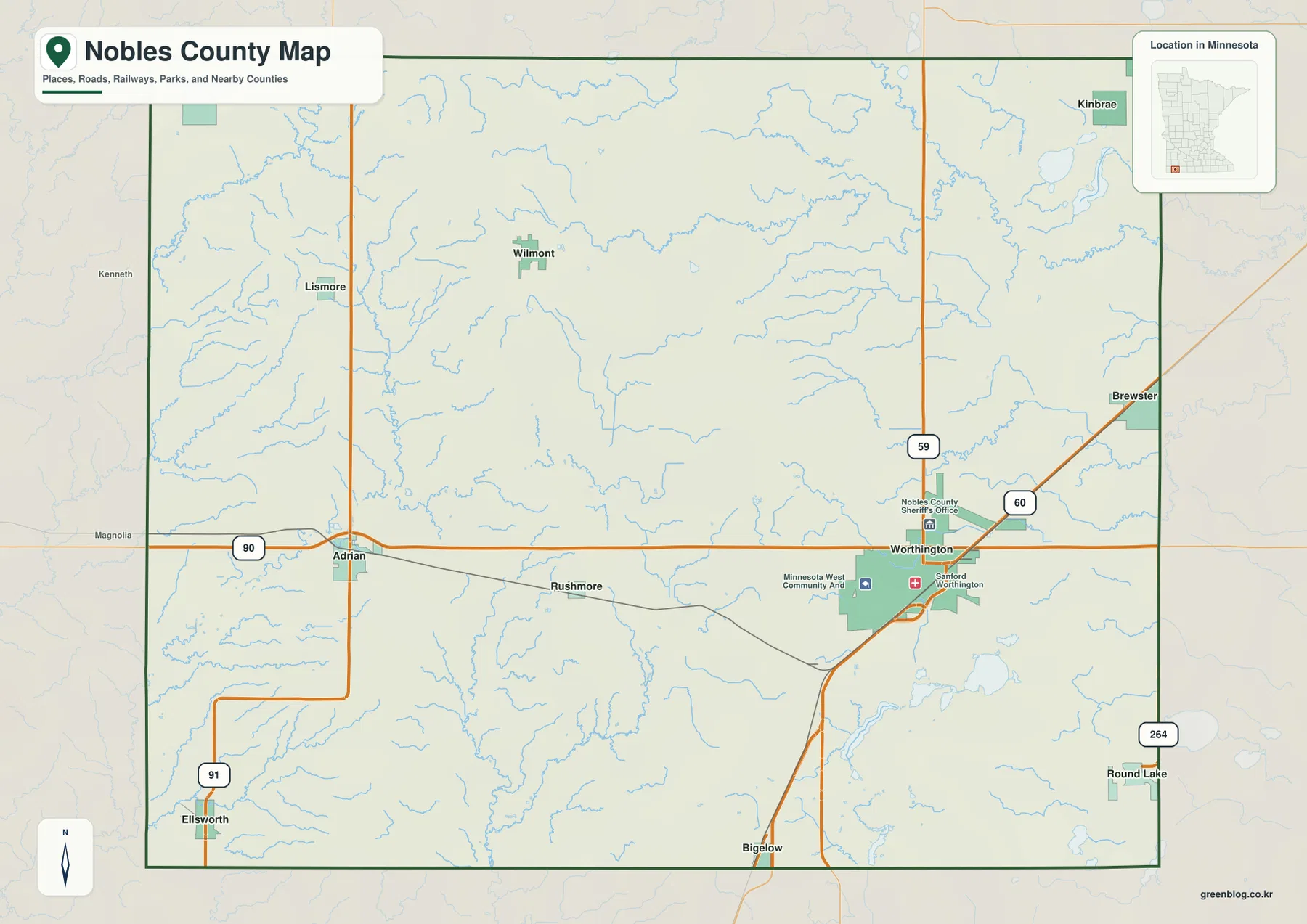
I-90 provides the clearest connection toward Rock County on the west and Jackson County on the east. U.S. 59 links Worthington with areas north and south, and Minnesota 264 is a useful reference near Round Lake. The map is designed for orientation, roads, and general county boundaries. Parcel ownership, zoning, and legal boundary questions should be checked with Nobles County’s official mapping or survey resources.
Six Major Communities Spread across the County
The ranked city distribution map highlights six major communities. Its index lists Worthington at 13,780, Adrian at 1,236, Brewster at 687, Ellsworth at 428, Rushmore at 362, and Round Lake at 333. Worthington is far larger than the other entries, but the smaller places are spread across the county rather than clustered around the main city. The index is useful for the comparison shown on this map; current official population estimates should be checked against the latest Census data when needed.
Worthington occupies the eastern-southern side of the county, while Adrian is well to the west along I-90. Rushmore lies between them but slightly south of the interstate corridor. Brewster is northeast of Worthington, and the two edge communities—Ellsworth in the southwest and Round Lake in the southeast—are separated by a large portion of the county. That geometry makes the ranked map more informative when location is considered together with city size.
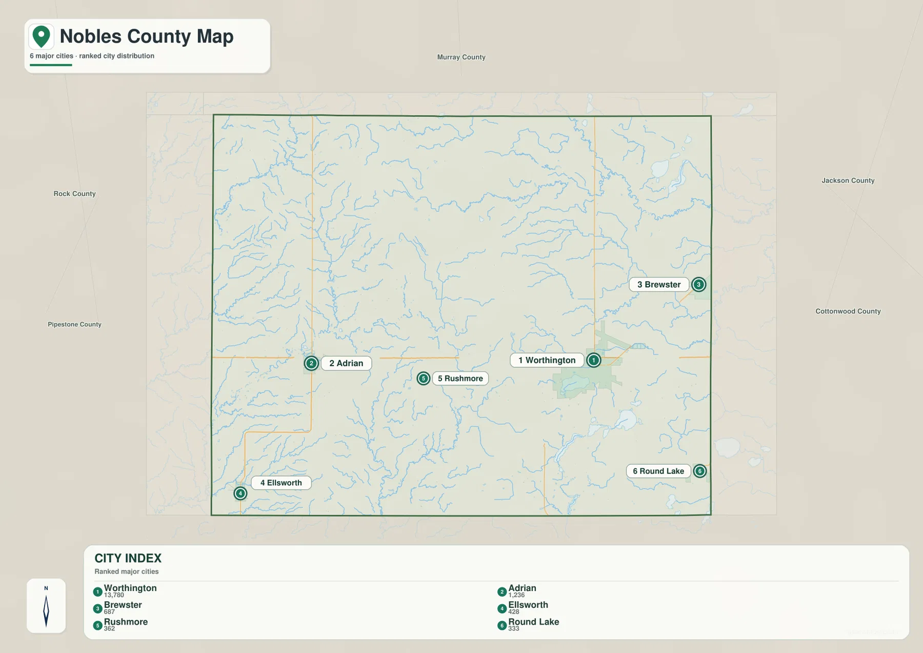
Regional labels add another layer of context. Murray County lies to the north, Jackson County to the east, Rock County to the west, and Iowa is directly south of Nobles County. The state line therefore matters for communities near the southern edge, particularly Ellsworth and Round Lake. Pairing the city map with the county overview is the best way to see both the simplified distribution and the roads that actually connect the towns.
Okabena and Ocheda Lakes beside Separate River Systems
Okabena Lake and Ocheda Lake are the most recognizable water features around Worthington. Okabena lies immediately beside the city, while the larger Ocheda system stretches farther south. Minnesota DNR maintains county-specific information for Lake Ocheda, including a management plan and public-access details. On the water map, the two lakes form a distinct southeastern cluster compared with the creek-dominated western side of the county.
In the southwest, the Little Rock River runs toward the southern boundary and is joined by Little Rock Creek. Kanaranzi Creek occupies the central-western part of the county, while Champepadan Creek appears farther northwest. These channels create a network of narrow valleys through an area that can appear almost uniform on the road map. Their directions become especially useful when compared with the shaded-relief map.
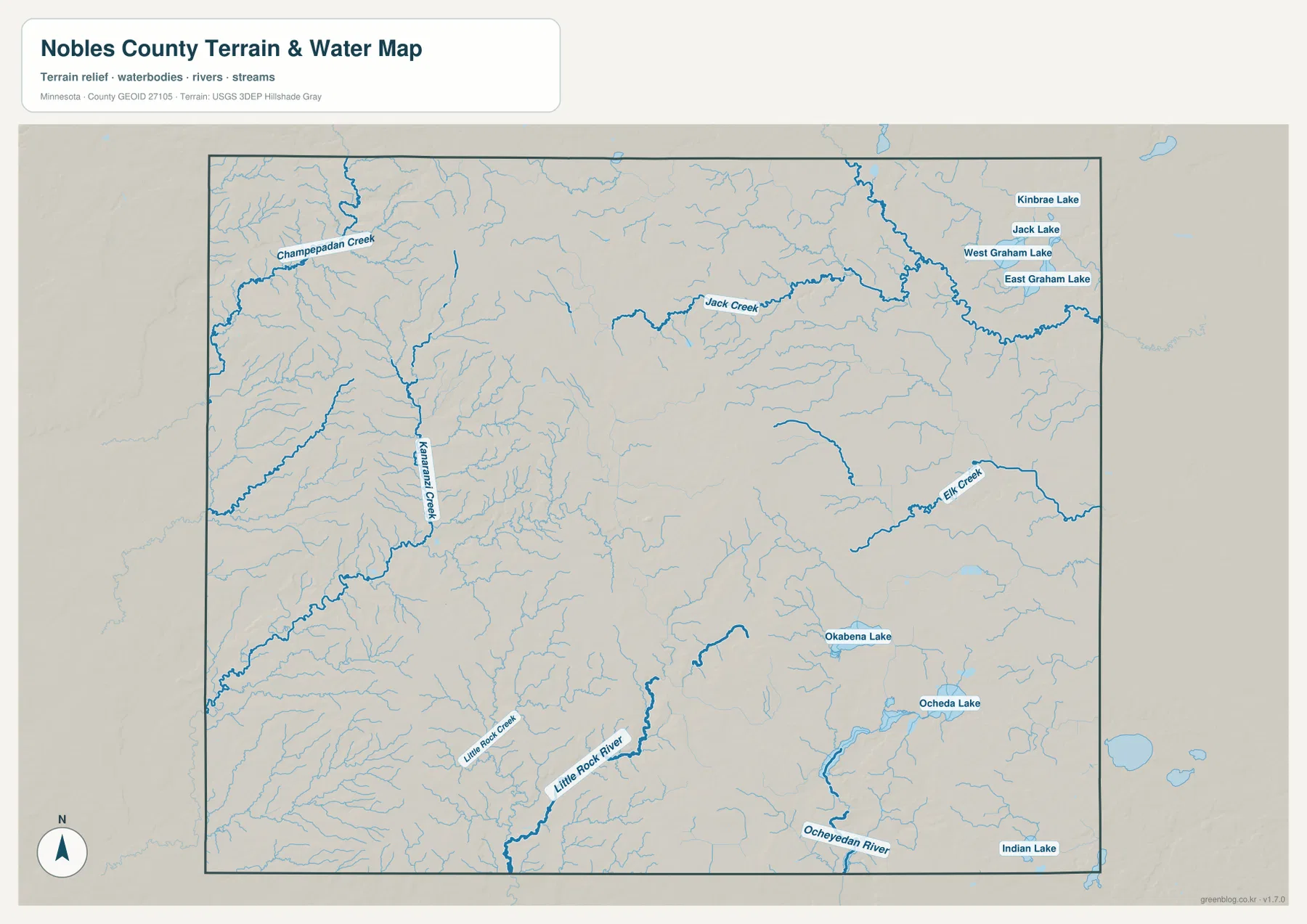
The eastern and northeastern sides contain a different set of water features. Jack Creek and Elk Creek wind across the upper half, and Kinbrae Lake, Jack Lake, West Graham Lake, and East Graham Lake form a small northeastern lake group. The Ocheyedan River appears in the southeast, with Indian Lake close to the county edge. Nobles County therefore contains several separate drainage areas rather than one dominant river crossing the entire county.
This map is intended for geographic reference, not for determining flood risk, water depth, navigation, shoreline ownership, or legal public access. For recreation on Okabena Lake, Ocheda Lake, or other waters, use current Minnesota DNR and local information for access conditions, rules, and management updates.
High Central-Western Uplands above Lower Eastern Terrain
The elevation map reveals a surprisingly strong local contrast. Its legend gives an actual range of about 428 to 551 meters and a mean near 487 meters. Brown and orange tones dominate much of the central-western and northwestern county, while greener terrain appears toward the east and in parts of the southwest. The pattern shows that Nobles County is not one uniform flat surface even though its road network crosses broad agricultural land.
A long belt of higher ground runs through the central and western interior. Narrow valleys cut into this upland and extend toward Kanaranzi Creek, the Little Rock River, and other drainage channels. The shaded relief makes those valleys visible as lower green or yellow lines between higher ridges. This is one of the clearest places where the water and elevation maps explain each other.
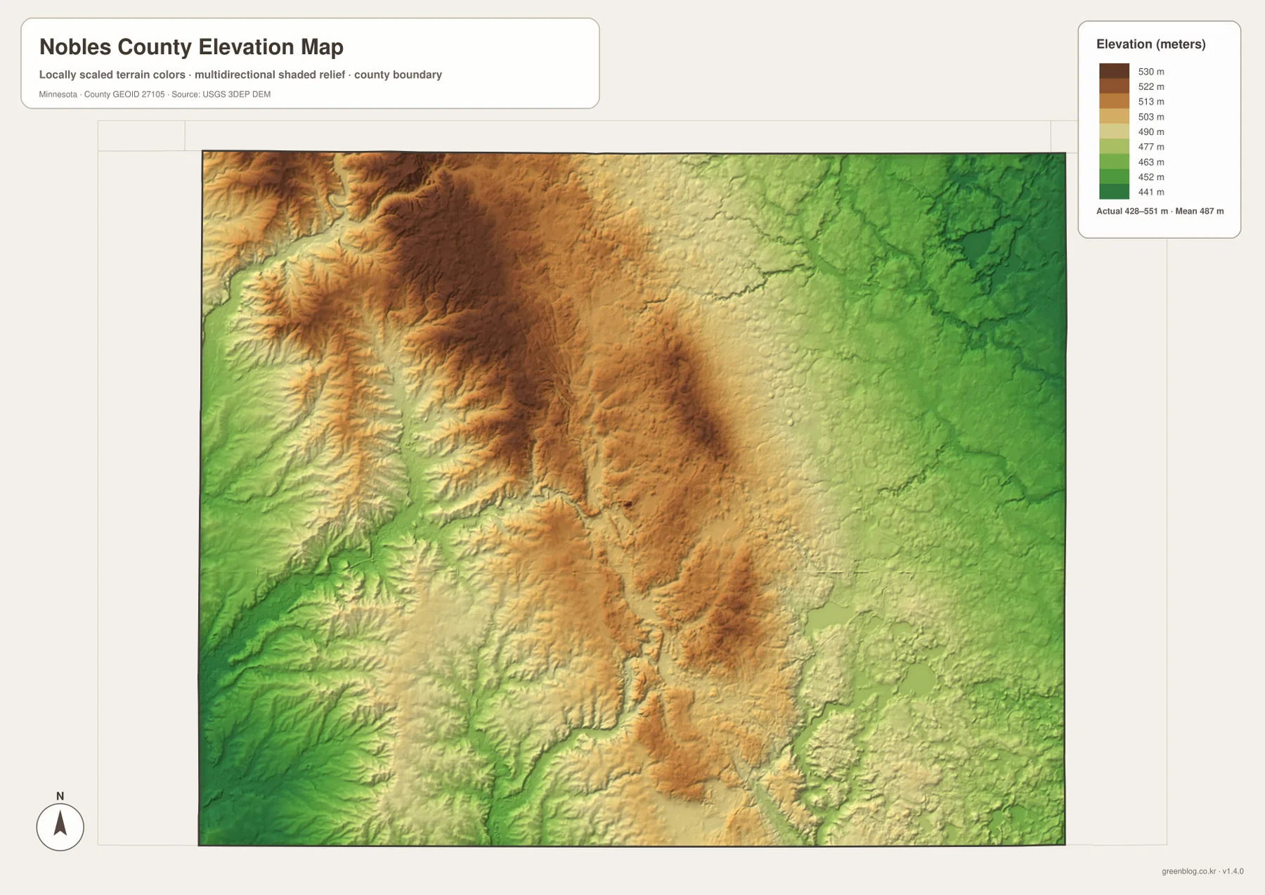
The eastern side around Worthington and Brewster is generally lower than the highest central-western terrain, and some southwestern valleys near Ellsworth also fall into lower shades. That does not mean the county slopes in one simple direction. A better description is a high central-western interior broken by drainage corridors that descend toward lower areas on several sides.
The elevation colors are locally scaled to show variation within Nobles County, so the same shade on another county map may correspond to a different absolute height. The shaded surface is useful for regional interpretation but not for engineering, construction, drainage design, or legal surveying, which require more precise source data or field measurements.
Choosing the Best View for Roads, Water, or Relief
For road orientation, start with the county overview. It shows the I-90 route from Adrian to Worthington, the U.S. 59 north–south crossing, and the Minnesota 60 connection toward Brewster. The ranked city map is the better choice when the main goal is simply to compare the six highlighted communities without the full road network.
For natural features, begin with Okabena and Ocheda lakes near Worthington, then compare the Little Rock River, Kanaranzi Creek, Jack Creek, and Ocheyedan River. The elevation map adds the broader setting by showing a high central-western band and lower drainage corridors around it. Viewed together, the water and relief maps make the county’s landscape much more understandable than either layer alone.
The WebP images on the page are optimized for quick viewing. The downloadable ZIP contains the corresponding high-resolution JPG originals for the county overview, city distribution, water, and elevation maps. Each image is 3638 by 2572 pixels, making the original files preferable for printing or zooming into small road numbers and stream labels.
A practical way to study the county is to start in Worthington, follow I-90 west toward Adrian, then move northeast toward Brewster and the Graham lakes. After that, trace the Little Rock and Ocheyedan river systems on the water map and finish with the elevation view. The sequence connects the county’s roads and towns with the central-western uplands and the lower stream corridors surrounding them.
Frequently Asked Questions
Which map is best for finding Worthington and Interstate 90?
Use the county overview first. Worthington is shown where I-90 meets U.S. 59, with Adrian to the west and Brewster to the northeast. The ranked city map is a useful second view when you want to compare Worthington with Adrian, Brewster, Ellsworth, Rushmore, and Round Lake.
Where are Okabena Lake and Ocheda Lake?
Both are in the southeastern part of Nobles County near Worthington. Okabena Lake sits directly beside the city, while Ocheda Lake extends farther south. The water map shows them most clearly together with the Ocheyedan River and nearby smaller drainage features.
Where is the highest terrain in Nobles County?
The elevation map shows the strongest high ground across the central-western and northwestern interior. The actual county range on the legend is about 428–551 meters, with a mean near 487 meters. Lower green terrain appears toward the east and in several valleys around the high interior.
Map File Information
The ZIP contains the original high-resolution JPG versions of the Nobles County overview, city distribution, water, and elevation maps.
- File Type: ZIP containing 4 JPG files
Related Maps
Sources and References
- Nobles County official website – county government and local information
- Minnesota DNR Lake Ocheda management plan – Lake Ocheda location, management, and public-access context
- U.S. Census Bureau TIGER/Line Shapefiles – county boundary and geographic reference data
- USGS National Hydrography – river, stream, and lake reference data
- USGS 3D Elevation Program – elevation reference data
Green Map creates custom-edited map images using open geographic data sources such as geoBoundaries, Natural Earth, OpenStreetMap, and government open data. These maps are edited visual materials, not raw data files, and are provided for education, documents, presentations, and graphic reference.