Hampden County occupies the southern part of western Massachusetts, directly above the Connecticut state line. Its geography is easiest to understand from the Springfield area, where several cities cluster along the Connecticut River, and then expand outward to Westfield and the hillier west, Palmer and Monson in the east, and Longmeadow and Agawam along the southern edge. The county is long from west to east, but its most concentrated urban area sits near the central river valley.
This page includes a general Hampden County map, a ranked major-city map, and a terrain-and-water reference map. High-resolution JPG versions of the same maps are available in the downloadable ZIP. The general map is the best starting point for cities, roads, and boundaries; the city map simplifies the county to six major urban reference points; and the terrain-and-water map emphasizes the Connecticut, Westfield, Chicopee, and Quaboag river systems together with reservoirs and surrounding relief.
Table of Contents
Springfield, the Connecticut River, and the county’s main road network
Springfield is the most useful place to begin reading the general county map. It lies slightly south of the county’s central area, with Chicopee immediately to the north and Holyoke farther upstream. West Springfield sits across the Connecticut River, while Agawam extends south of West Springfield. These communities form a compact cluster compared with the more widely spaced towns farther east and west, making the central river corridor the clearest anchor for county-wide orientation.
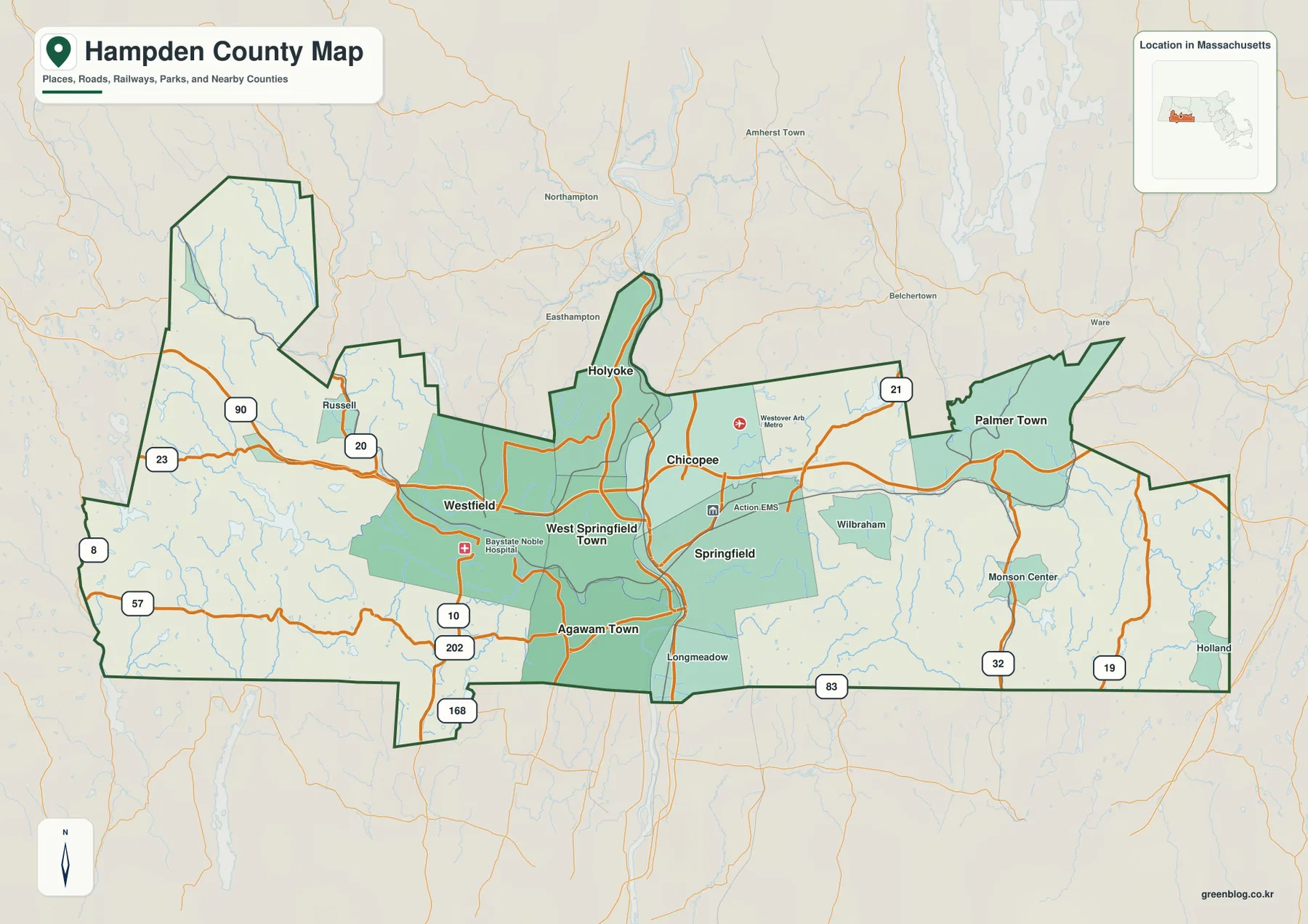
Interstate 90, the Massachusetts Turnpike, is the simplest east-west reference. It crosses the county from the Russell and Westfield side, approaches the central urban area, and continues toward Palmer. Route 20 provides another recognizable east-west line between Westfield, the Springfield area, and communities farther east. A major north-south highway corridor also serves Springfield; the National Park Service’s directions to Springfield Armory identify I-91 as a principal approach. Together, these routes explain why the Springfield area appears as a meeting point between the county’s east-west and north-south travel patterns.
Westfield is an important western reference because it sits between the dense central valley and the rougher terrain toward Russell and the Berkshire County side. I-90 and Route 20 continue west from the city, while Route 202 and Route 57 help define the southwestern part of the county. The boundary in this area is irregular, with projections and corners that can make the western section look disconnected at first glance. Locating Westfield before tracing the county line makes those shapes easier to follow.
The eastern side has a different settlement pattern. Palmer Town is a strong reference near I-90 and Route 20, with Route 21 extending northward. Monson Center lies southeast of Palmer near Route 32, while Route 19 appears farther east toward the Holland side. Wilbraham sits between Springfield and the eastern towns. The greater spacing between these labels contrasts with the tightly grouped Springfield-Chicopee-Holyoke area and helps show how development becomes less concentrated away from the Connecticut River corridor.
Along the southern edge, Longmeadow and Agawam help identify the Massachusetts-Connecticut border. Longmeadow lies directly south of Springfield on the east side of the Connecticut River, while Agawam is on the west side below West Springfield. Route 83 provides a useful north-south reference near Longmeadow, and Route 168 appears near the southwestern boundary around Agawam. Following these places from east to west also makes the county’s southern outline easier to distinguish from the internal municipal areas shown in green.
The general map is most useful when the task is to connect communities with the roads that serve them. A practical sequence is to locate Springfield, trace the central urban cluster north to Holyoke, then use Westfield and Palmer as western and eastern anchors. This map is not intended to replace current traffic information, construction notices, or turn-by-turn navigation. For those purposes, current transportation sources should be checked separately.
Six major cities concentrated around the central valley
The ranked city map removes most road labels and emphasizes six places: Springfield, Chicopee, Westfield, Holyoke, West Springfield Town, and Agawam Town. Springfield is marked first, followed by Chicopee, Westfield, Holyoke, West Springfield, and Agawam. The CITY INDEX also prints a numerical value beside each place. Those figures should be treated as values from the dataset used to build this particular map rather than as a claim about the latest official population. Current demographic counts are better checked directly with the U.S. Census Bureau.
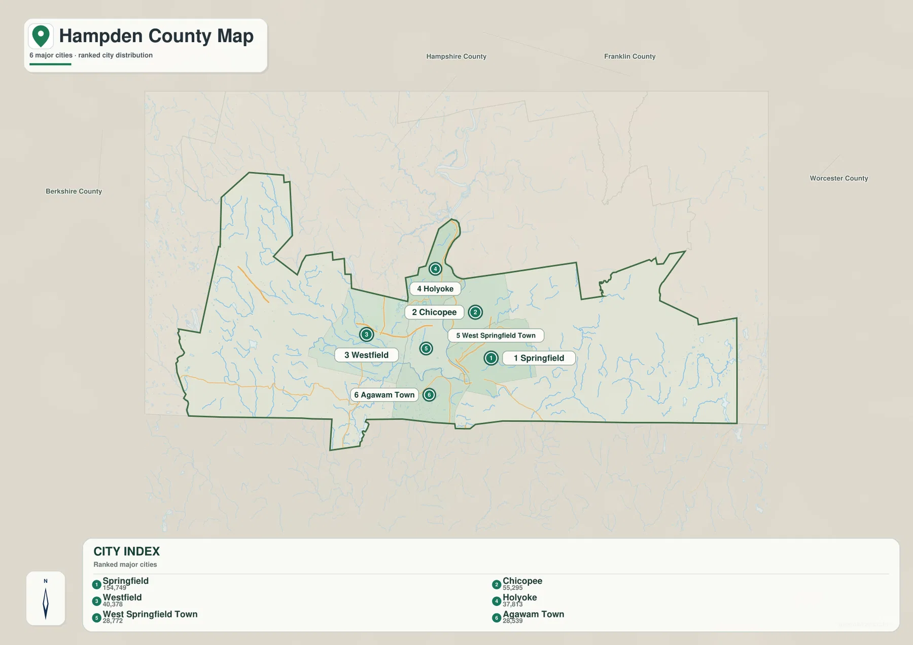
Five of the six highlighted places form a very compact group: Springfield, Chicopee, Holyoke, West Springfield, and Agawam. Westfield is the one major city shown farther west. That arrangement matches the general map, where the central river corridor contains the densest road network and the largest concentration of labels. For a presentation or classroom graphic, this simplified view is useful because it makes the urban pattern visible without asking the reader to sort through many route numbers and smaller place names.
Holyoke and Chicopee illustrate how the Connecticut River helps organize the central cluster. Holyoke lies north of Springfield near a bend in the river, while Chicopee occupies the area between Holyoke and Springfield and extends farther east. West Springfield faces Springfield from the west side of the river, and Agawam continues south along that side. Once these relative positions are clear, the water map becomes easier to understand because the major river can be followed through the same set of communities.
Springfield also has a strong historical identity that gives extra context to its prominence on the map. Springfield Armory National Historic Site, managed by the U.S. National Park Service, is located in the city. NPS describes the Armory as the nation’s first federal arsenal and explains its importance in manufacturing and technological development. That history is not the subject of the county map itself, but it provides a useful real-world reference for readers who recognize Springfield through the Armory or other regional institutions.
The outer labels on the city map add regional context. Berkshire County appears to the west, Hampshire County to the north, Worcester County to the east, and Franklin County farther north and northeast. These labels help place Hampden County within western Massachusetts rather than showing it as an isolated shape. The city map should still be understood as a selective index, not a complete municipal map: Palmer, Monson, Wilbraham, Longmeadow, Russell, and many other communities are better located on the general county map.
The Connecticut, Westfield, and Chicopee rivers across contrasting terrain
The Connecticut River is the strongest feature on the terrain-and-water map. It comes south through the Holyoke area, passes between Chicopee and West Springfield and then between Springfield and West Springfield, and continues toward Agawam and Longmeadow before entering Connecticut. Massachusetts basin documentation describes the same lower-river sequence through the Holyoke-Chicopee, West Springfield-Chicopee, West Springfield-Springfield, and Agawam-Longmeadow boundaries. Seeing the river beside the city labels makes clear why the central valley is such a useful framework for understanding Hampden County.
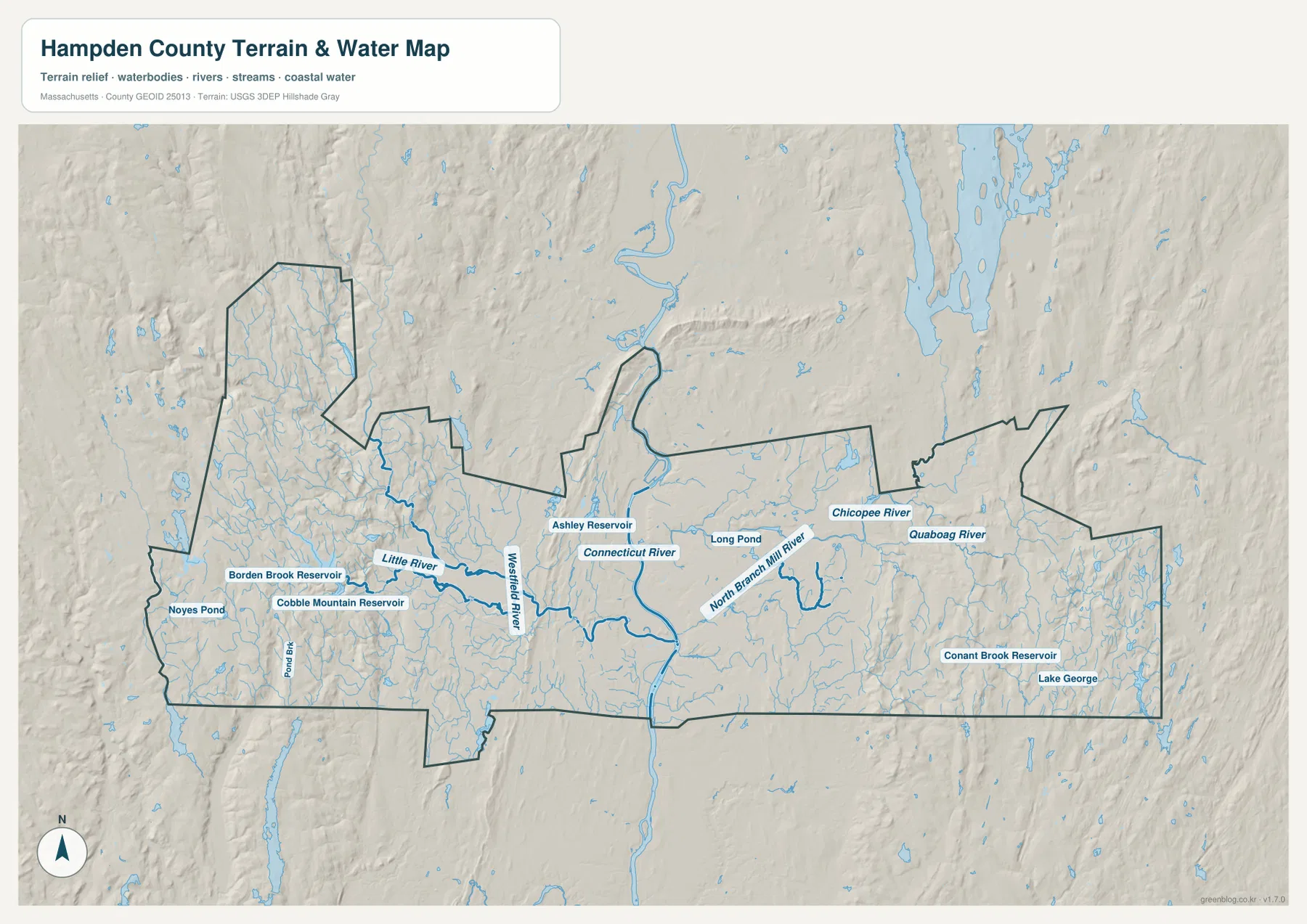
The Westfield River enters from the west and approaches the Connecticut River near the central-southern part of the county. The Little River is also labeled, while Cobble Mountain Reservoir, Borden Brook Reservoir, and Noyes Pond provide useful reference points in the western hills. Shaded relief is much stronger here than it is around Springfield. Ridges and narrow valleys repeat across the map, which helps explain why roads west of Westfield curve through the landscape instead of forming a broad, regular grid.
Cobble Mountain Reservoir and Borden Brook Reservoir are especially noticeable because they occupy larger water surfaces than the small ponds around them. Numerous tributaries descend through the surrounding uplands. These features make the western part of Hampden County easier to organize geographically: rather than treating it as an empty area beyond Westfield, the map shows a network of valleys, reservoirs, and streams. The reference map does not, however, provide reservoir operating rules, drinking-water restrictions, access information, or water-quality conditions, which should be checked with the responsible agencies.
East of the Connecticut River, the Chicopee River is the clearest named waterway. It approaches the central urban area from the east and connects the Springfield-Chicopee side of the county with a broader river system extending toward Palmer. Farther east, the North Branch Mill River and the Quaboag River are labeled, and Long Pond appears in the interior. These features help separate the eastern drainage pattern from the Westfield River system in the west.
Conant Brook Reservoir and Lake George appear toward the southeastern side. The terrain there is not as rugged as the far west, but the hillshade still shows rolling ground and numerous small drainage lines. Monson and Holland on the general map sit within this more dispersed eastern landscape, where communities are farther apart and no single broad urban corridor dominates. Comparing the two maps helps explain why the eastern towns feel more separated than Springfield, Chicopee, and West Springfield.
Ashley Reservoir appears near Holyoke, while small tributaries feed toward the Connecticut River from both sides of the central valley. Around Holyoke, the river’s bend and the narrow shape of the city are visually distinctive. Farther south, the Connecticut River remains the main water reference for Springfield and Longmeadow, while the Westfield River becomes important for Agawam and West Springfield. The same central urban area therefore looks slightly different depending on whether the reader is following roads, municipal labels, or waterways.
Relief can be summarized in three broad zones. The west is the most visibly rugged, with stronger hillshade, reservoirs, and narrow stream valleys. The Connecticut River corridor through Springfield, Chicopee, West Springfield, and nearby communities appears broader and smoother. The east rises into more rolling terrain again, with the Quaboag system and many smaller streams. This contrast is useful for understanding why the largest urban concentration occupies the central valley while settlements farther west and east are more spread out.
Each supplied map therefore answers a different practical question. Use the general map when roads, community names, and the county boundary need to be seen together. Use the city map when a clean graphic of the six highlighted urban centers is enough. Use the terrain-and-water map for rivers, reservoirs, ponds, and relief, especially when comparing the western hills with the central Connecticut River valley and the more dispersed eastern side. Moving between the three views gives a more complete picture than relying on any one of them alone.
The terrain-and-water map is a regional reference rather than a flood, parcel, navigation, wetland-regulation, dam-safety, or engineering product. Blue line width does not represent exact channel width or depth, and hillshade is not survey-grade elevation measurement. For flood hazards, water quality, reservoir operations, legal boundaries, or engineering work, current specialized datasets from the appropriate Massachusetts or federal agency should be used.
Frequently Asked Questions
Why are so many of the highlighted cities close to Springfield?
The supplied maps show Springfield, Chicopee, Holyoke, West Springfield, and Agawam concentrated along the central Connecticut River valley. Major roads also converge in this part of the county, while the terrain map shows a broader valley than the rugged western uplands. The city map is designed to emphasize this major-city pattern, but it is not a complete map of every municipality in Hampden County.
Which map is best for locating the Westfield and Chicopee rivers?
The terrain-and-water reference map is the clearest choice. It shows the Westfield River coming from the western hills toward the Connecticut River and the Chicopee River approaching from the east. The Quaboag River, North Branch Mill River, reservoirs, ponds, and relief are also visible. For flood zones, water quality, or regulated water boundaries, use the specialized official map for that purpose.
What is the easiest road to use as an east-west reference across Hampden County?
I-90, the Massachusetts Turnpike, is the clearest east-west reference on the supplied general map. It connects the western side near Russell and Westfield with the central urban area and continues toward Palmer in the east. Route 20 is another useful reference between Westfield, Springfield, and the eastern side. Check current traffic and construction information separately when planning an actual drive.
Map File Information
The ZIP contains the original high-resolution JPG versions of the general Hampden County map, the ranked major-city map, and the terrain-and-water reference map described on this page.
- Included Files: general county map, major-city map, terrain-and-water reference map
- File Type: JPG
Related Maps
Sources and References
The following official resources are useful for checking Hampden County city context, Springfield access, Connecticut River basin information, boundaries, and hydrography.
- Mass.gov – Cities and Towns of the Commonwealth of Massachusetts
- U.S. National Park Service – Springfield Armory National Historic Site
- Mass.gov – Integrated Lists of Waters and Related Reports
- U.S. Census Bureau TIGER/Line Shapefiles
- USGS National Hydrography
Green Map creates custom-edited map images using open geographic data sources such as geoBoundaries, Natural Earth, OpenStreetMap, and government open data. These maps are edited visual materials, not raw data files, and are provided for education, documents, presentations, and graphic reference.