Crow Wing County sits in Minnesota’s north-central lake country, with Brainerd and Baxter forming the clearest urban center in the southwest and smaller communities extending north toward Pequot Lakes, Breezy Point, and Crosslake. Crosby, Ironton, Cuyuna, and Deerwood form another close group farther east. Between these places are hundreds of lakes, branching rivers, wooded uplands, and road corridors that bend around water. The result is a county whose southern road network and northern lake country look noticeably different even before terrain is added.
This page brings those differences together with a general county map, a simplified major-city map, a terrain-and-water map, and a county-scale elevation map. After comparing the maps on screen, you can download the same four maps as high-resolution JPG files in one ZIP archive for printing or personal projects. A useful way to begin is to locate Brainerd on Routes 371 and 210, follow the roads north into the Whitefish and Pelican lake areas, and then compare those corridors with the Pine, Gull, and Nokasippi river systems.
Table of Contents
Brainerd and Baxter anchor the southwest road network
The general map makes Brainerd and Baxter the easiest starting points for orientation. The two cities sit close together in the southwest, where several important roads converge. Route 371 runs north from the Brainerd-Baxter area toward Nisswa and Pequot Lakes, while Route 210 crosses Brainerd and continues east toward Crosby and Deerwood. Route 25 extends south from the central part of the county, and Routes 18 and 169 appear farther southeast. These roads create a recognizable framework even though the county is too lake-filled to form a simple rectangular street pattern.
North of Brainerd, the character of the road system changes. Route 371 continues toward Nisswa and Pequot Lakes, but Breezy Point and Crosslake sit farther east among large and small lakes. Fifty Lakes and Emily appear still farther north, with Route 6 providing a north-south connection near Emily. The road lines often curve around water rather than taking direct paths, which is one reason the straight geographic distance between two communities can be quite different from the driving distance.
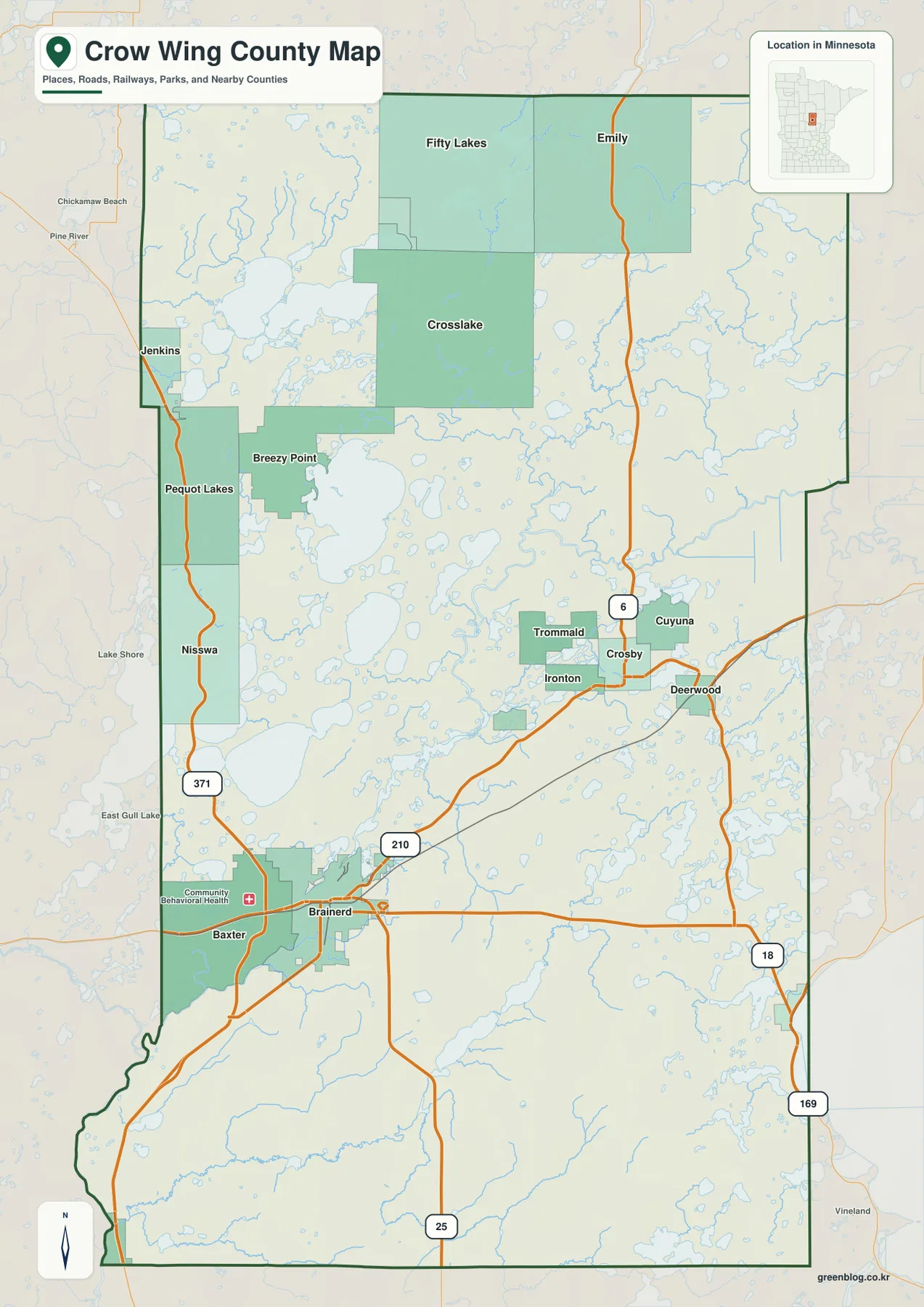
The eastern community cluster is also easy to recognize. Crosby, Ironton, Cuyuna, Trommald, and Deerwood appear close together around the Route 210 corridor, with Route 6 heading north from near Crosby. Names are packed more tightly here than across much of the northeast and southeast, where large areas contain few prominent city labels. This contrast makes the map useful for separating three broad parts of the county: the Brainerd-Baxter urban area, the northern resort-and-lake communities, and the Cuyuna-area towns in the east.
Nearby county labels provide additional orientation. Cass County lies to the north, Aitkin County is east of Crow Wing County, and Morrison and Mille Lacs counties appear along the western and southern sides of the mapped area. The county outline is irregular in places, especially toward the southwest, so the road and city labels are more useful than a simple compass description alone. Brainerd’s southwest location is particularly important because it is not near the geometric center of the county even though it is the largest mapped city.
Six major cities reveal separate southwest, north, and east clusters
The city map removes most secondary detail and highlights Brainerd, Baxter, Breezy Point, Crosslake, Crosby, and Pequot Lakes. Brainerd and Baxter sit together in the southwest. Pequot Lakes, Breezy Point, and Crosslake are spread through the northern lake district, while Crosby stands apart in the eastern interior. This arrangement shows that the county is not organized around one compact metro area. Instead, several smaller centers serve different parts of a landscape broken up by lakes and wooded land.
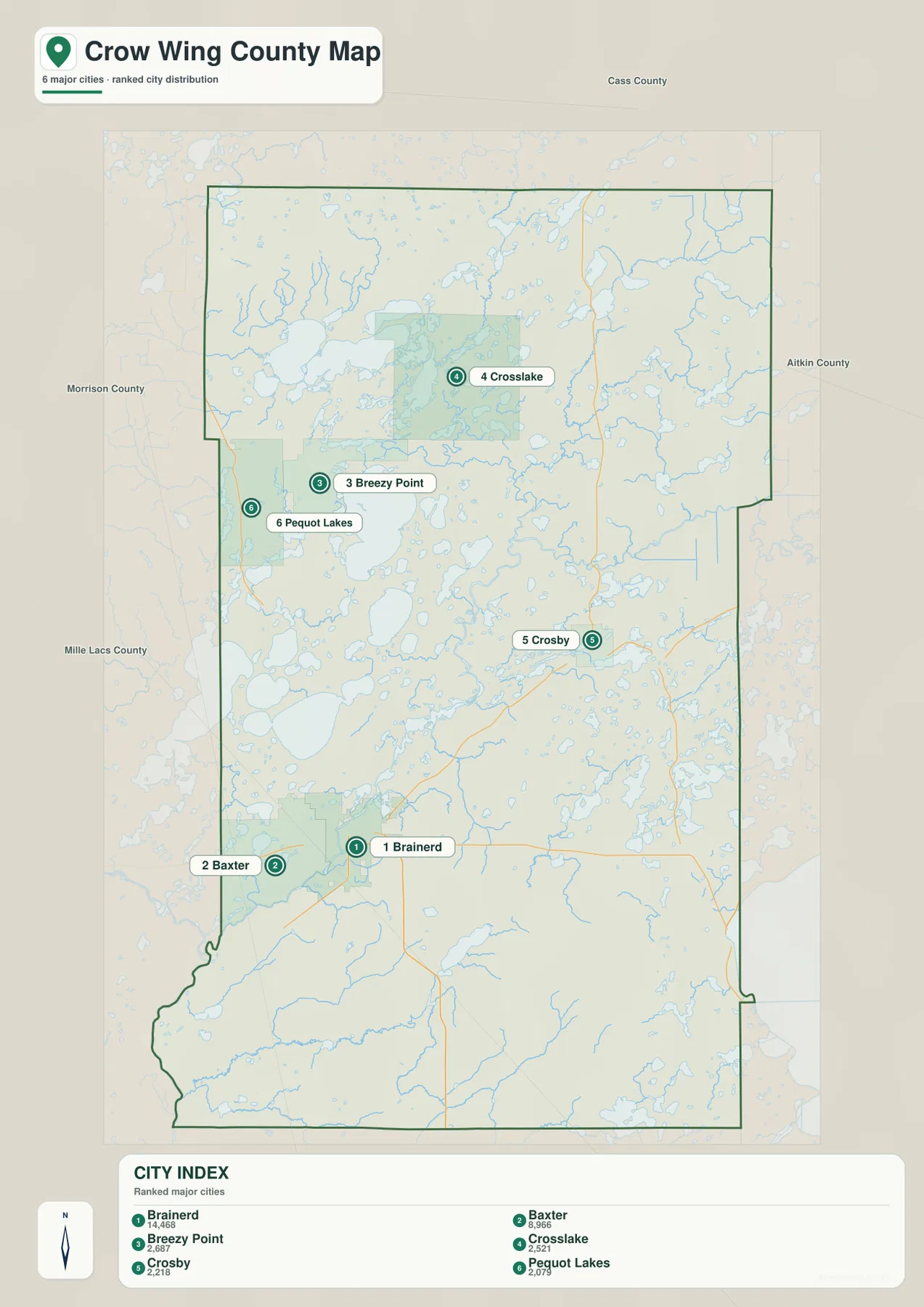
The city index printed on the map lists Brainerd at 14,468, Baxter at 8,966, Breezy Point at 2,687, Crosslake at 2,521, Crosby at 2,218, and Pequot Lakes at 2,079. Those numbers are best treated as the ranking values used to make this map rather than as a substitute for the latest population estimates. For geographic reading, their main value is to show the scale difference between the Brainerd-Baxter pair and the smaller lake-country communities.
The simplified city view is useful when road detail would distract from the basic settlement pattern. For example, it makes the gap between Brainerd and Crosslake easy to see, and it shows that Breezy Point and Pequot Lakes occupy the same broad northern half without sitting directly on top of one another. Crosby’s isolated position to the east is equally clear. When actual travel matters, however, the general map should be used alongside it because the lake network forces many roads to curve rather than follow straight lines.
This separation also helps explain why different parts of Crow Wing County can feel distinct. Brainerd and Baxter are closely connected by roads and development, while Crosslake and Breezy Point are embedded in a landscape where shorelines and lake access shape local movement. Crosby belongs to the Cuyuna area, where several small towns and former mining landscapes are concentrated. The county map becomes much easier to understand once those three geographic groupings are recognized.
Whitefish and Pelican lakes dominate the northern water country
The terrain-and-water map makes Crow Wing County’s defining feature unmistakable: water is everywhere. Crow Wing County’s official Lakes & Rivers page says the county has more than 400 lakes and 75 rivers, with more than 2,000 miles of shoreline. On the supplied map, Lower Whitefish Lake is one of the largest named water bodies in the northwest, while Pelican Lake occupies a broad area farther south. Lake Edward and North Long Lake add more large surfaces between the northern lake communities and the Brainerd area.
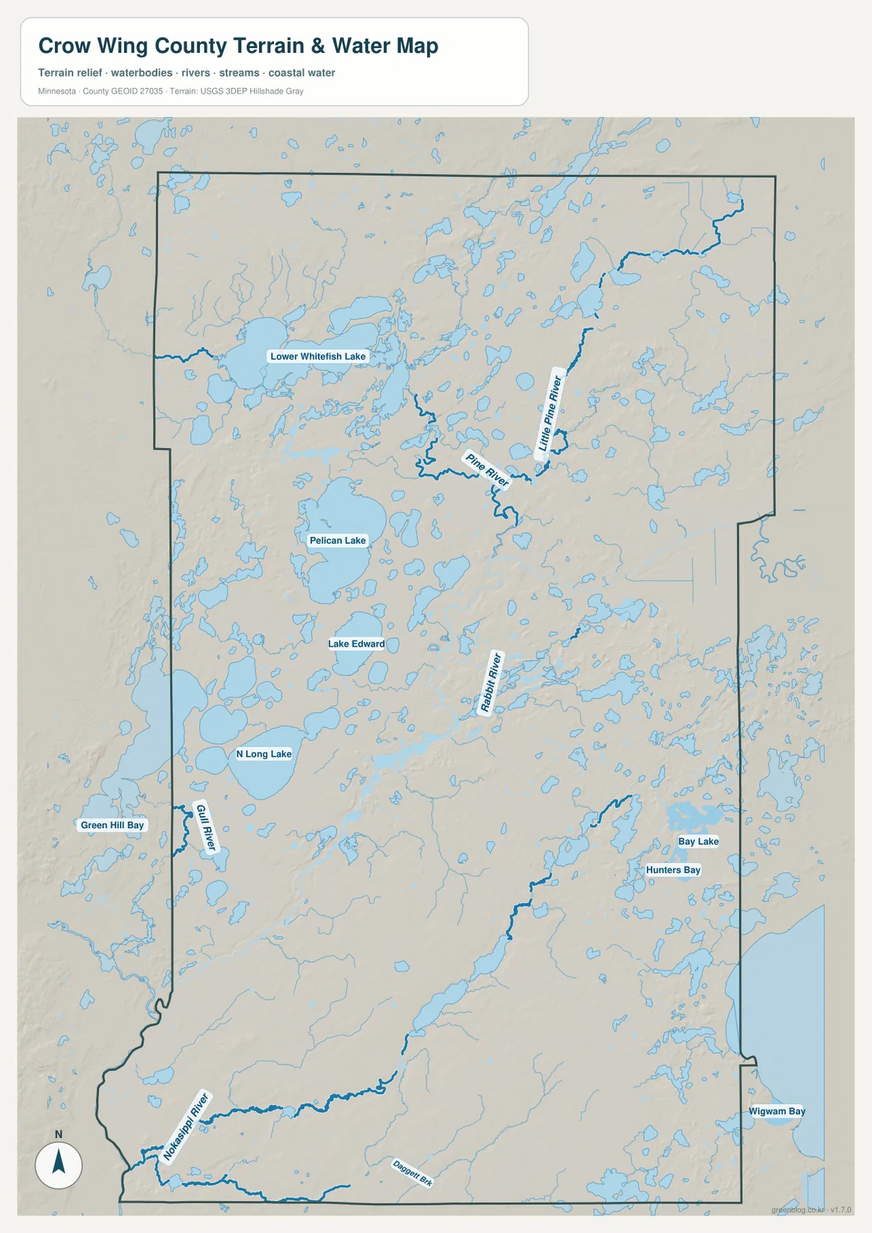
The northern rivers often connect or pass between lake basins. Pine River bends through the north-central part of the county, while Little Pine River descends farther east. Gull River appears in the west near North Long Lake and Green Hill Bay, and Rabbit River is labeled in the east-central interior. Farther south, the Nokasippi River runs across the lower part of the county, accompanied by smaller tributaries such as Daggett Brook. The network is not a single river valley; it is a web of lakes, connecting channels, and separate drainage routes.
The eastern and southeastern portions remain water-rich even where the largest lakes are absent. Bay Lake, Hunters Bay, and Wigwam Bay appear near the eastern edge, while many smaller lakes and wet areas fill the surrounding landscape. That pattern differs from the northwest, where Lower Whitefish Lake and other large water bodies create broad, continuous blue areas. Comparing those sections shows why one general description of “lake country” is not enough: some parts are dominated by large lake surfaces, while others contain smaller, scattered water bodies and river corridors.
This map is a regional reference, not a legal shoreline, flood, wetland, or navigation document. Public access, regulated shoreland, wetlands, private property, and navigability require current county, state, or federal information. Crow Wing County maintains separate shoreland and wetland guidance, and Minnesota DNR and USGS provide more detailed water resources. For map reading, the strongest use of this layer is to see where cities and roads sit relative to the county’s major lakes and rivers.
Crosby and Cuyuna form a distinct eastern landscape
The Crosby area looks different from the northern lake communities and from Brainerd. Crosby, Ironton, Cuyuna, Trommald, and Deerwood are packed into a relatively small area around Routes 210 and 6. The general map therefore shows a concentration of place names in the eastern interior that is unusual elsewhere in the county. Route 210 provides the clearest connection back toward Brainerd, while Route 6 leads north from the Crosby area toward the upper half of the county.
This cluster is associated with the Cuyuna Iron Range and today’s Cuyuna Country State Recreation Area. Minnesota DNR describes the Cuyuna Lakes State Trail as an eight-mile paved route from Crosby to Riverton within the recreation area, which also contains natural lakes and numerous deep lakes created in former mine pits. That background helps explain why the eastern group of towns and water bodies has a different character from the resort communities around the Whitefish and Pelican lake districts.
Not every mine lake or recreation feature is labeled on the county-scale water map, so the page should not be used to define former mining boundaries. It does, however, provide a useful orientation to the Crosby-Deerwood area before a visitor opens a more detailed state recreation map. Crow Wing County’s park information also includes Milford Mine Memorial Park near Crosby, adding a local historical reference to the broader geographic picture.
Higher northwest and southeast ground surround lower lake basins
The elevation map shows an actual county-scale range of roughly 348 to 453 meters, with a mean near 382 meters. The highest broad area appears in the northwest, where darker brown covers the upper-left part of the county. Moving toward the center and west-central lake district, the colors shift into darker greens that represent lower ground. The terrain is therefore not a uniform flat surface despite the abundance of lakes and gentle-looking roads.
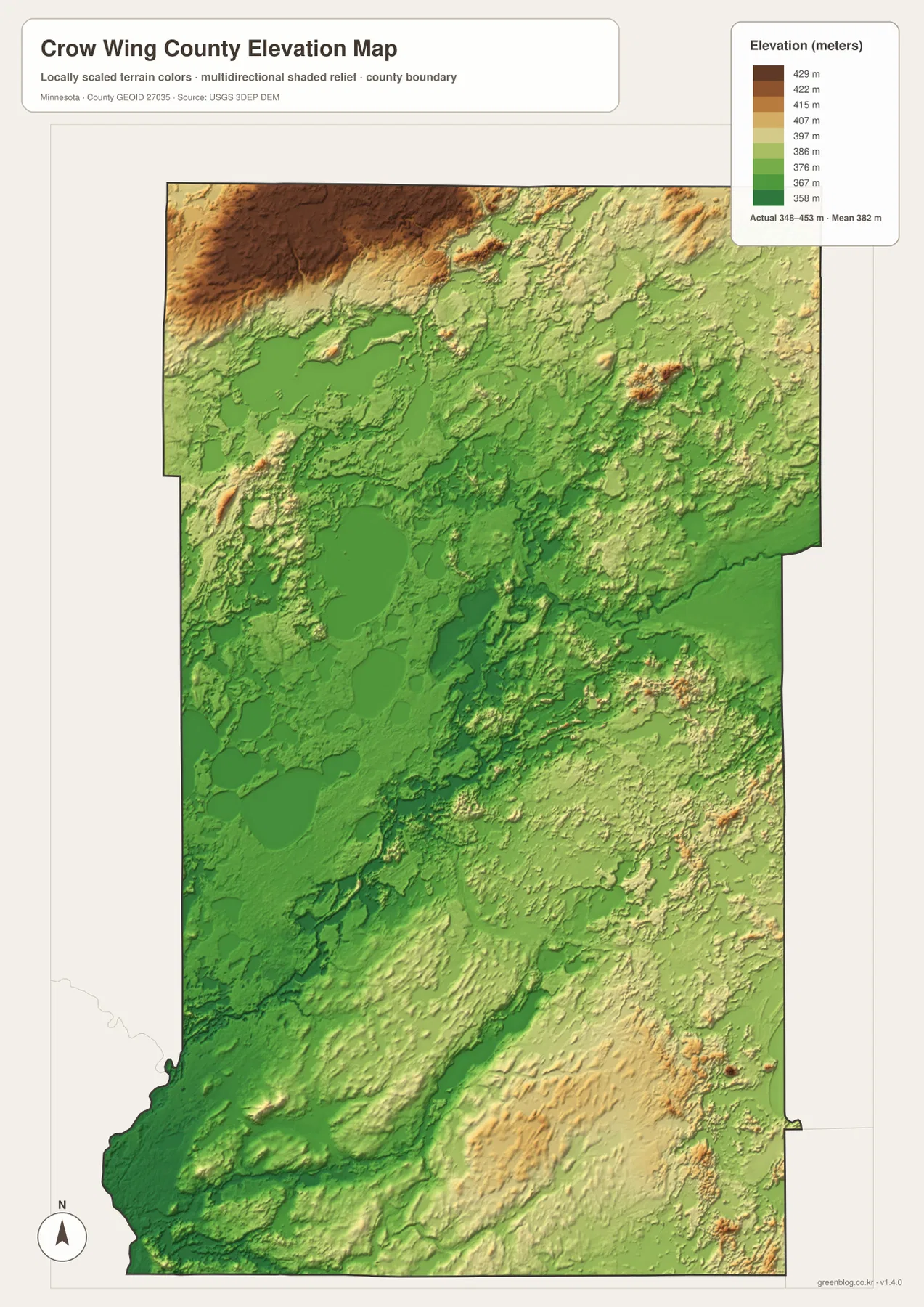
Pelican Lake and the surrounding west-central landscape sit within a broad low green area. Similar lower terrain extends toward North Long Lake and the Brainerd side of the county. In the northeast, long narrow ridges and shallow depressions create a more textured surface. Farther southeast, tan and brown tones become more common again, indicating another substantial zone of higher ground rather than a simple downhill slope from north to south.
Comparing the water and elevation maps adds useful context. Lower basins coincide with several large lakes, and river valleys create narrow low corridors through surrounding terrain. Pine River and Gull River occupy visible low routes, while the broad northwest highland sits beyond the main west-central lake basins. In the southeast, the Nokasippi River and smaller streams cut through rolling higher terrain. These relationships are easier to see when the two maps are placed side by side.
The colored surface is intended for county-level comparison, not survey work. It cannot provide a certified elevation for a parcel, structure, road, or drainage project. Engineering, construction, and property-specific questions require higher-resolution source data and, when appropriate, field measurement. The USGS 3D Elevation Program is a better starting point for detailed elevation products, while the map here is suited to recognizing the county’s main high and low areas.
A practical sequence from Brainerd roads to lakes and relief
For a first look at Crow Wing County, begin with Brainerd and Baxter on the general map. Follow Route 371 north to Nisswa and Pequot Lakes, then locate Breezy Point and Crosslake farther east among the lakes. Return to Brainerd and trace Route 210 toward Crosby and Deerwood. That simple exercise creates a road framework for the county before the large number of lakes and smaller place names are added.
The city map is the next useful step because it strips away most background detail. It highlights the southwest Brainerd-Baxter pair, the northern Pequot Lakes-Breezy Point-Crosslake group, and Crosby in the east. Once those positions are familiar, the water map explains why the northern communities are not connected by perfectly direct lines. Large lakes such as Pelican and Lower Whitefish occupy substantial space, while dozens of smaller lakes force roads into narrower corridors of dry land.
The elevation map then adds a third dimension. The Brainerd and west-central lake area lies lower than the broad northwest highland, while another zone of higher relief rises across parts of the southeast. This helps separate road layout from terrain: not every bend is caused by elevation, and not every lake sits at the absolute lowest point, but the combination of water and rolling relief clearly constrains how communities and routes fit together.
For printed material, select the layer that matches the question. The general county map is strongest when road numbers and named communities matter. The city map works better for a simple regional comparison. The terrain-and-water map is the natural choice for lakes and rivers, and the elevation map is best for broad relief. Because all four use the same county outline, readers can switch between them without losing the basic orientation.
What to keep in mind when using a lake-country map
In a county with so much water, a blue shape on a map does not automatically mean public access. Boat launches, county parks, public beaches, private shoreline, and protected areas have different rules and locations. Crow Wing County’s Recreation pages maintain separate information for public lake access, parks, beaches, and trails, while its Lakes & Rivers section explains shoreland and wetland considerations. Those current sources should be checked before making travel, land-use, or access decisions.
The Whitefish Chain and Crosslake area provides a good example. The map contains dense clusters of lakes and narrow land connections, so a simplified city map can show where Crosslake lies but cannot explain the best way to reach a particular shoreline. The general map adds major roads, yet it still omits many local details. A detailed official access map is the right next step after the county map has established the broader location.
The same is true in the Crosby-Cuyuna area. Cities, recreation land, former mining terrain, trails, and small lakes lie close together, but a county-scale map cannot define each facility or former mine boundary. Minnesota DNR resources are more appropriate for trail routes and recreation-area details. The maps on this page are best used as a geographic overview that helps a reader decide which detailed source to consult next.
Frequently Asked Questions
Which map is best for following the route from Brainerd to the northern lake communities?
Use the general county map when road numbers matter. It shows Route 371 leaving the Brainerd-Baxter area and heading north toward Nisswa and Pequot Lakes, with Breezy Point and Crosslake farther east in the lake district. The city map is a useful companion when you want a cleaner comparison of the communities without most secondary road and water detail.
How extensive is the lake and river network in Crow Wing County?
Crow Wing County’s official Lakes & Rivers page reports more than 400 lakes and 75 rivers, with over 2,000 miles of shoreline. The supplied water map illustrates that density with Lower Whitefish Lake, Pelican Lake, Lake Edward, North Long Lake, Pine River, Little Pine River, Gull River, Rabbit River, and the Nokasippi River among the labeled features.
Can the 348-453 meter elevation range be used for surveying or construction?
No. The range describes the county-scale elevation surface used for visual comparison. It is useful for distinguishing the higher northwest and southeast from lower central lake basins, but it is not a certified elevation for a parcel, road, structure, or drainage project. Detailed official elevation data and site-specific measurements are required for those uses.
Map File Information
The ZIP contains the original high-resolution JPG versions of the four Crow Wing County maps shown on this page.
- Included Files: county map, city map, water map, elevation map
- Printable Size: 2572 × 3638 px for each JPG
- File Type: ZIP containing 4 JPG images
Related Maps
Sources and references
- Crow Wing County official website – county administration and local information
- Crow Wing County Lakes & Rivers – lakes, rivers, shoreland, and wetland information
- Crow Wing County Parks – county recreation sites including Milford Mine Memorial Park
- Minnesota DNR Cuyuna Lakes State Trail – Crosby-Cuyuna trail and recreation-area background
- U.S. Census Bureau TIGER/Line Shapefiles – official boundary and geographic data
- USGS National Hydrography – rivers, streams, and water features
- USGS 3D Elevation Program – elevation data and products
Green Map creates custom-edited map images using open geographic data sources such as geoBoundaries, Natural Earth, OpenStreetMap, and government open data. These maps are edited visual materials, not raw data files, and are provided for education, documents, presentations, and graphic reference.