Cottonwood County lies in southwestern Minnesota, where small cities are spread across a broad agricultural landscape rather than gathered into one urban corridor. Windom anchors the southern part of the county, Mountain Lake and Bingham Lake sit to the southeast, and Westbrook, Storden, and Jeffers form a looser chain across the west and center. The maps on this page make three features especially clear: the road network converging near Windom, the headwaters and branches of the Watonwan River system, and a noticeable elevation change from higher western ground toward lower terrain in the east and northeast.
You can view four map types here and download the matching high-resolution JPG files in one ZIP archive. The general map is best for boundaries, roads, and named places; the city map strips the view down to six ranked communities; the terrain-and-water map emphasizes rivers, creeks, and lakes; and the elevation map shows countywide relief with a locally scaled color range. Starting with Windom and the numbered highways, then comparing the water and elevation maps, gives a straightforward way to understand how the county fits together.
Table of Contents
Windom at the junction of the county’s main road directions
The general county map makes Windom the easiest place to use as an orientation point. Route 71 comes down from the north and reaches the city near the southern boundary. Route 62 approaches from the west, while Route 60 leaves Windom toward Bingham Lake and Mountain Lake in the southeast. Those three directions create a clear hub at the bottom of the county. The map is not dense with large roads, yet the few major corridors are easy to follow and explain how communities that look widely separated on the page remain connected.
A second major corridor runs east-west across the upper half of the county. Route 30 passes through Westbrook and Storden, continues near Jeffers, and crosses the north-south route before heading toward the eastern county line. This creates a different travel pattern from the Windom area: western communities line up along an east-west road, while the southeastern cities sit along the diagonal route from Windom. Rather than one central strip of development, Cottonwood County shows several small clusters organized around a few highway intersections.
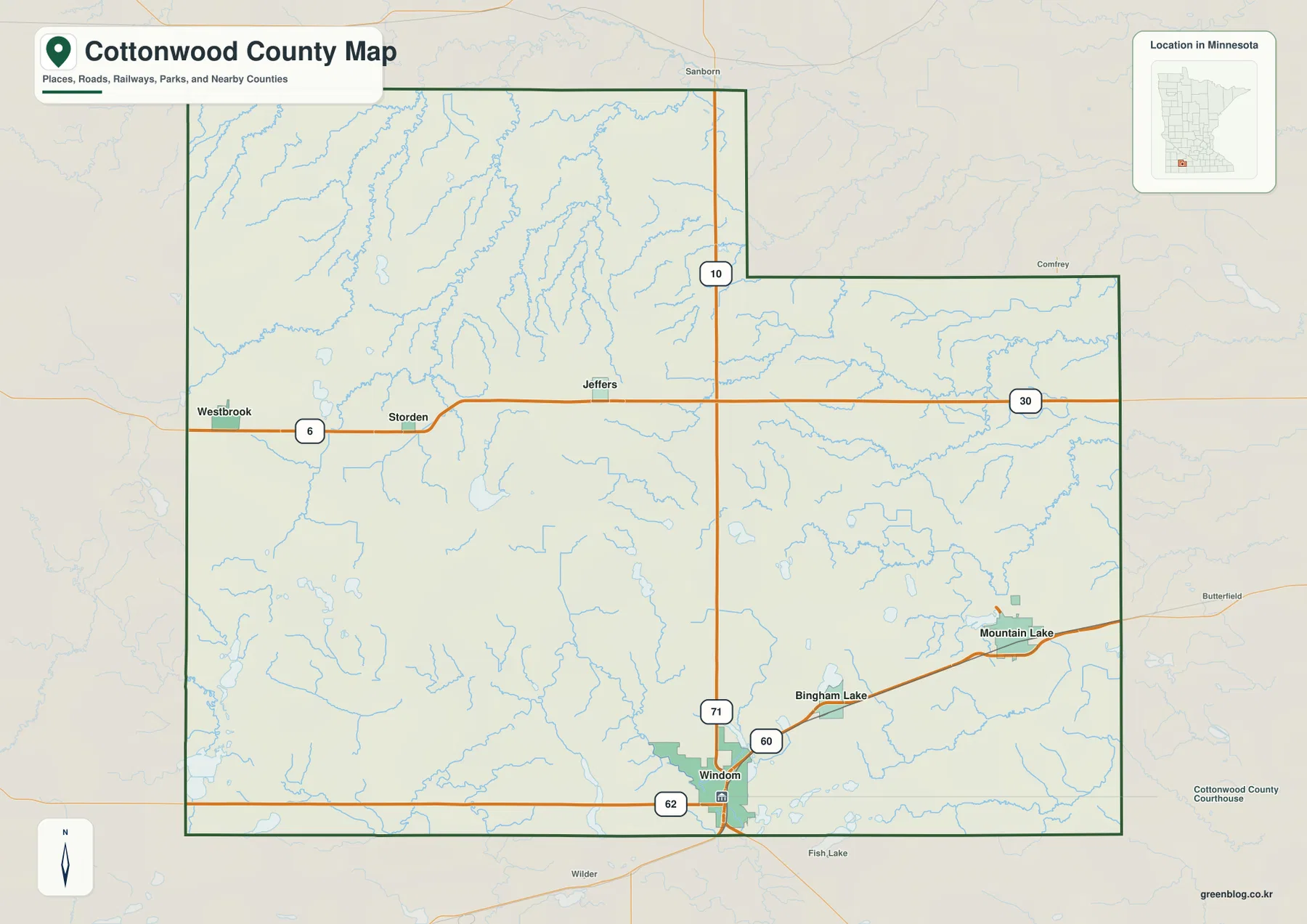
Mountain Lake stands out in the southeast, with Bingham Lake positioned between it and Windom. Westbrook and Storden are much farther west along Route 30, and Jeffers occupies a more central position close to Route 71. This arrangement is useful for understanding local direction before looking at a navigation map. A visitor comparing Windom and Mountain Lake, for example, can immediately see that they belong to the same southeastern road corridor, while a trip toward Westbrook requires moving across the county rather than following that diagonal line.
The surrounding county labels provide another layer of context. Redwood County is to the north, Brown and Watonwan counties are on the northeast and east, Martin County is to the southeast, Jackson County is directly south, Nobles County is southwest, and Murray County is west. Cottonwood County’s official information guide describes the county as having eighteen townships and an area of about 650.39 square miles. That broad rural footprint helps explain why the named communities appear as separate points with substantial open space between them.
Six mapped cities split between a southern corridor and a western line
The city map removes much of the road detail and highlights six communities: Windom, Mountain Lake, Westbrook, Jeffers, Storden, and Bingham Lake. Windom is ranked first and sits close to the southern border. Mountain Lake is second in the southeast, while Westbrook and Storden occupy the western part of the county. Jeffers appears between those groups but farther north, and Bingham Lake lies on the diagonal corridor between Windom and Mountain Lake. The simplified view makes the county’s settlement pattern easier to compare than the busier general map.
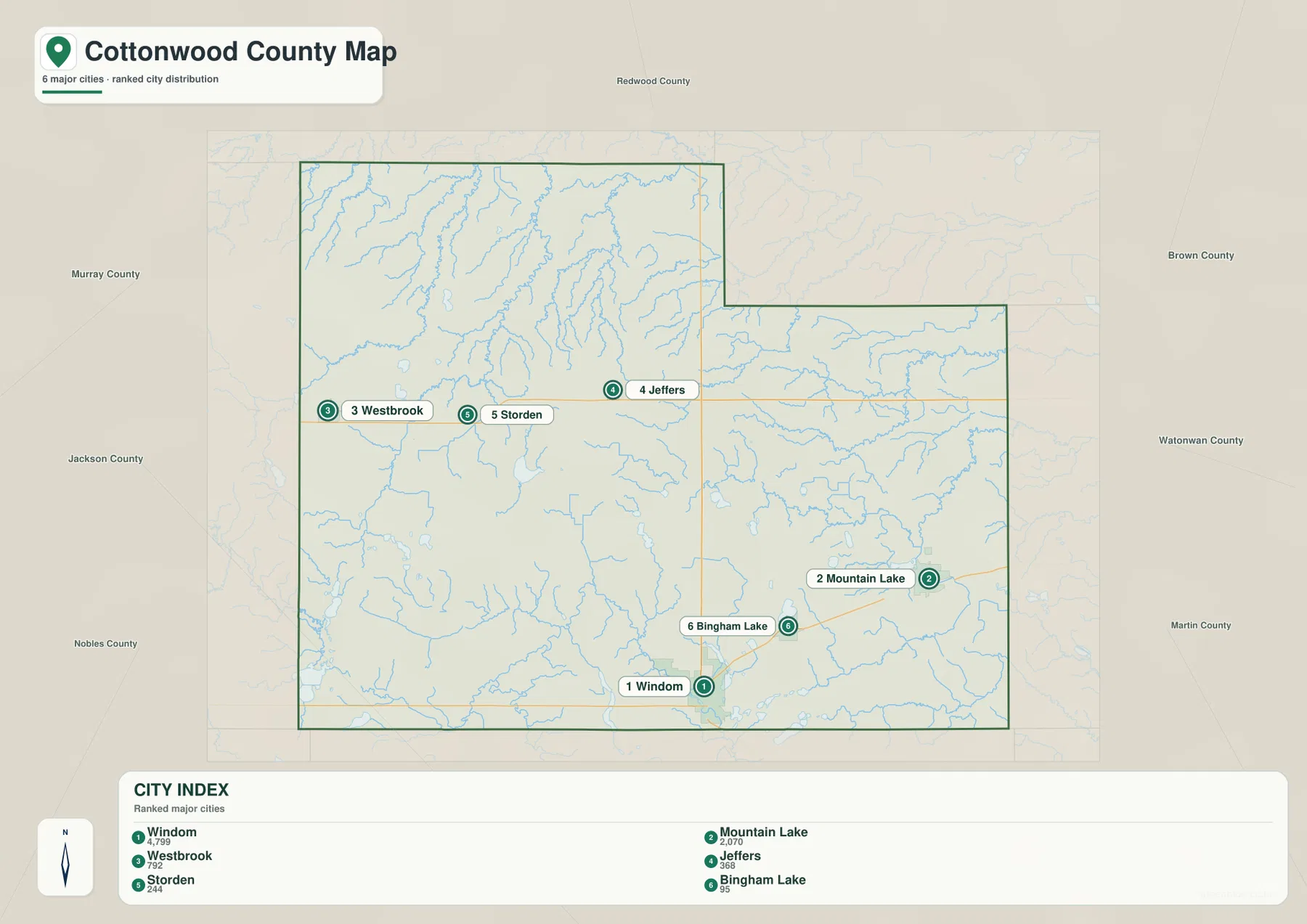
The map’s city index shows values of 4,799 for Windom, 2,070 for Mountain Lake, 792 for Westbrook, 368 for Jeffers, 244 for Storden, and 95 for Bingham Lake. On this page, those values are treated as the ranking information printed on the supplied map rather than as a substitute for a current official population table. The spatial relationship matters more for map reading: the two highest-ranked places are in the south and southeast, while the smaller western communities line up along the Route 30 corridor.
This uncluttered map is useful when roads would distract from the question being asked. It works well for a classroom slide showing where the principal cities sit, a quick comparison of western and southeastern settlement, or a project that needs a clean county outline with a few reference points. When the next question is how those cities connect, the general map adds the road network. When the question shifts to rivers and lakes around those communities, the water map becomes more informative.
The Watonwan headwaters begin among Cottonwood County’s central uplands
The terrain-and-water map changes the emphasis from transportation to drainage. Highwater Creek and Dutch Charley Creek are labeled in the northwest. The Little Cottonwood River crosses the central and eastern part of the county, while the North Fork Watonwan River, the Watonwan River, and the South Fork Watonwan River form a more prominent network in the east and southeast. The Minnesota Pollution Control Agency states that the Watonwan River rises in central Cottonwood County and then flows eastward through the larger watershed. That description matches the map’s pattern of streams leaving the higher central part of the county toward lower ground to the east.
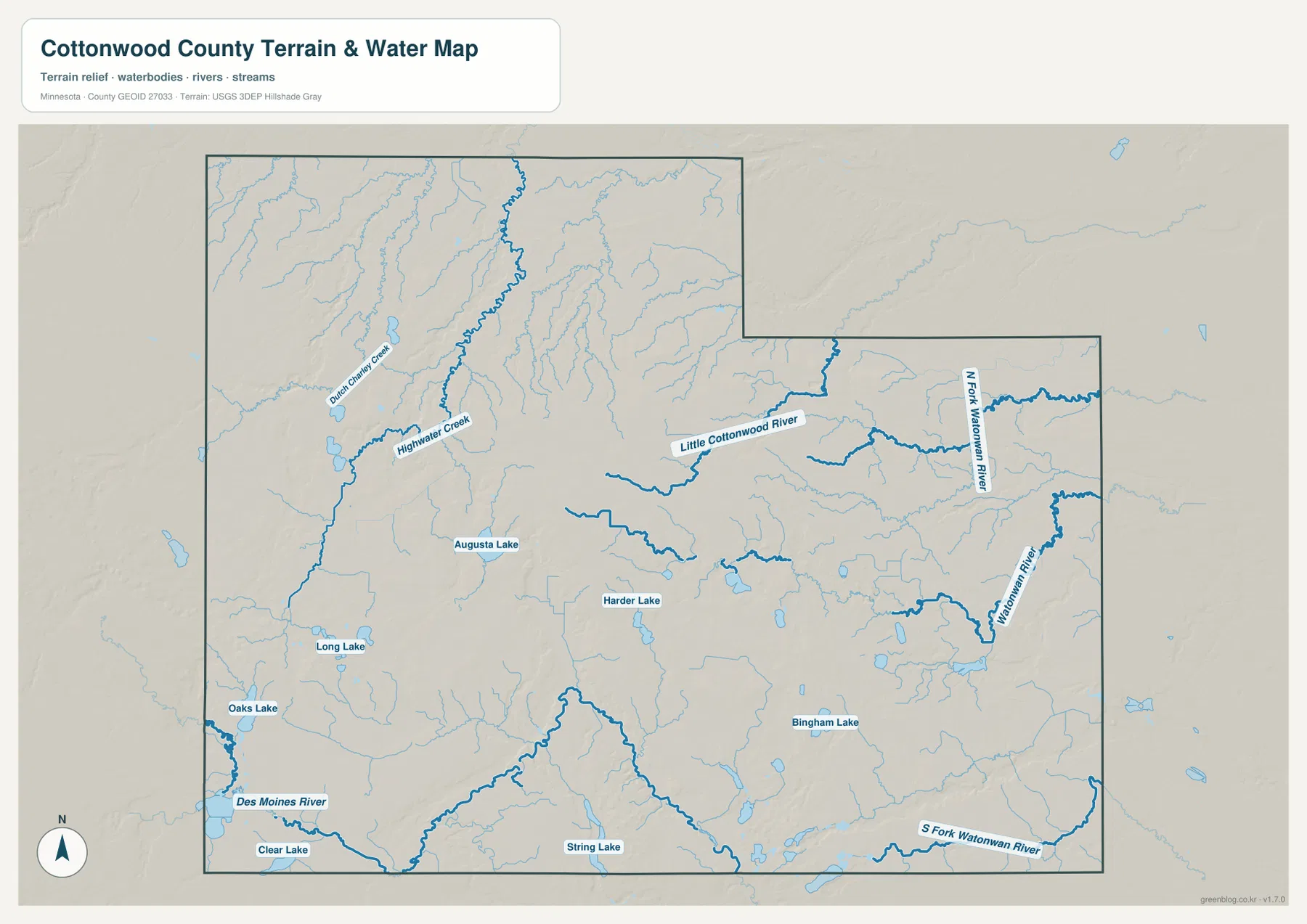
Named lakes are scattered rather than concentrated in one large lake district. Long Lake, Oaks Lake, and Clear Lake are shown in or near the southwestern side of the mapped area. Augusta Lake and Harder Lake sit closer to the center, while Bingham Lake and String Lake appear farther southeast. Numerous smaller water bodies and drainage lines fill the spaces between them. The result is a landscape where small lakes and branching streams matter more than a single dominant lake.
The Des Moines River is labeled just beyond the southwest part of the county map, adding useful regional context. Cottonwood County sits near divides that send water toward different larger river systems, and the western high ground helps separate those drainage directions. East-flowing branches of the Watonwan are especially clear, while the Little Cottonwood system occupies another part of the county. Looking at these waterways together with the relief shading explains more than a flat hydrography diagram would: stream direction and the shape of the land reinforce one another.
This water map is a geographic reference, not a flood-zone, navigation, wetland-regulation, or parcel product. A blue line shows the location of a mapped stream, but it does not establish whether a reach is navigable, whether a property is in a regulated floodplain, or where a legal shoreland setback begins. Those questions require current county, state, or federal records. For regional study, however, the map is effective because it puts named waterways and nearby relief into the same view.
Elevation falls from the western high ground toward the northeast and river corridors
The elevation map makes a broad west-to-east difference visible that is easy to miss on the road map. Its legend gives an actual range of about 313 to 479 meters and a mean near 412 meters. Browns and tan colors cover much of the west and southwest, and a large darker high area occupies the central part of the county. Greens become more common toward the north and northeast, showing lower terrain. The color change is gradual in some places and sharper along valleys cut into the higher land.
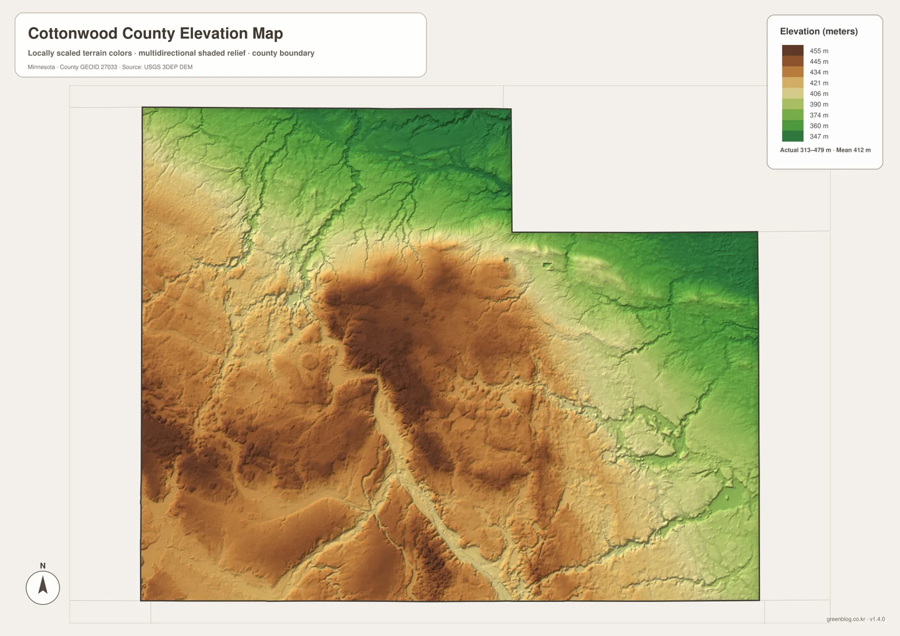
The high area around the county’s center is particularly important when the map is compared with the Watonwan system. The river begins in central Cottonwood County and flows east, while the North and South Forks occupy lower corridors farther east and southeast. The Little Cottonwood River follows another eastward drainage route. Darker green lines and valleys cut through lighter or brown uplands, giving a visual explanation for why the river network becomes more defined as it leaves the central high ground.
The western and southwestern portions are not one smooth plateau. Shaded relief reveals rounded rises, shallow depressions, and local valleys within the higher terrain. In the northeast, lower green areas are broader and less elevated relative to the western half. This is useful context for anyone who sees southwestern Minnesota only as flat farmland: at county scale the relief is modest compared with mountain regions, but the difference is large enough to influence drainage patterns and the direction of several major streams.
The elevation surface is intended for county-scale comparison. It should not be used as a survey elevation for a house, road project, drainage design, or legal boundary. Site-specific work requires more detailed elevation data and professional measurement. The USGS 3D Elevation Program is an appropriate source for higher-resolution elevation products, while this map remains useful for seeing where the county is relatively high or low at a glance.
Reading roads, cities, water, and relief as one county landscape
A practical way to use the four maps is to begin with the road network and then add one layer of information at a time. On the general map, locate Windom, Route 30, Route 60, Route 62, and Route 71. On the city map, compare the western Westbrook-Storden group with the Windom-Mountain Lake-Bingham Lake corridor. Then use the water map to see where the Little Cottonwood and Watonwan systems cross the county. The elevation map finally explains why so many of those streams move away from the higher central and western ground.
Jeffers provides a good example of how the maps complement one another. The general map places it close to the east-west Route 30 corridor and not far from the north-south route through the county. The water map shows important Watonwan drainage developing nearby, and the elevation map places the area close to higher central terrain. Windom tells a different story: it is the strongest road junction in the county, yet it does not sit in the highest part of the elevation map. Mountain Lake and Bingham Lake, meanwhile, occupy the southeastern corridor where road, water, and lower terrain begin to overlap more closely.
For print or presentation work, choose the map whose detail matches the question. The general county map works best when roads and named places must stay visible. The city map is cleaner for comparing communities. The terrain-and-water map is the strongest choice for explaining rivers, creeks, and lakes, and the elevation map is better for broad relief. Because all four use the same county outline, a reader can move from one to another without losing orientation.
These maps are designed for geographic understanding rather than legal or engineering decisions. U.S. Census Bureau TIGER/Line data is the appropriate starting point for official boundary datasets, USGS National Hydrography provides more detailed water information, and USGS 3DEP supplies higher-resolution elevation products. Cottonwood County’s official website and information guide provide local administrative context. Used together, those sources and the downloadable maps make it possible to move from a simple visual overview to more detailed research without confusing the purpose of each resource.
Frequently Asked Questions
Does the Watonwan River begin in Cottonwood County?
Yes. The Minnesota Pollution Control Agency describes the Watonwan River as rising in central Cottonwood County before flowing east through the larger watershed. The supplied water map also shows the Watonwan system and its North and South Forks developing across the central, eastern, and southeastern parts of the county. For exact stream segments and current management information, consult MPCA and USGS hydrography resources.
Which map is best for seeing the road connection between Windom and Mountain Lake?
The general county map is the best choice because it shows Route 60 leaving Windom toward Bingham Lake and Mountain Lake. The city map is cleaner when you only need to compare the locations of the communities, but it removes most of the road detail that explains how the southeastern corridor is connected.
Can the 313-479 meter elevation range be used for surveying or construction?
No. Those values describe the county-scale elevation surface used for visual comparison. They are helpful for distinguishing the higher western and central ground from the lower northeast, but they do not provide a certified elevation for a parcel, structure, road, or drainage project. Detailed official data and site measurements are required for those uses.
Map File Information
The ZIP contains the original high-resolution JPG versions of the four Cottonwood County maps shown on this page.
- Included Files: county map, city map, water map, elevation map
- Printable Size: 3638 × 2572 px for each JPG
- File Type: ZIP containing 4 JPG images
Related Maps
Sources and references
- Cottonwood County official website – county services and local information
- Cottonwood County Information Guide – townships, area, cities, and local reference information
- Minnesota Department of Transportation: Highway 30 in Cottonwood County – the Westbrook-Jeffers corridor and Highway 71 connection
- Minnesota Department of Transportation: Highway 60 – the Windom-Mountain Lake corridor
- Minnesota Pollution Control Agency: Watonwan River – headwaters and watershed background
- U.S. Census Bureau TIGER/Line Shapefiles – official boundary and geographic data
- USGS National Hydrography – rivers, streams, and water features
- USGS 3D Elevation Program – elevation data and products
Green Map creates custom-edited map images using open geographic data sources such as geoBoundaries, Natural Earth, OpenStreetMap, and government open data. These maps are edited visual materials, not raw data files, and are provided for education, documents, presentations, and graphic reference.