Tuscola County sits on the western side of Michigan’s Thumb, where Caro occupies a central position between the low Saginaw Bay side of the county and the higher hills farther east and south. Cass City, Vassar, Reese, Millington, and Mayville form separate local centers rather than one continuous urban strip. Roads, the Cass River system, and a distinctive diagonal band of higher ground make the county especially easy to compare across the supplied map layers.
This page explains the county map, ranked city index, water map, and elevation map using the place names and terrain visible in the files. High-resolution A3 JPG originals for all four maps are included in one downloadable ZIP for printing, classroom work, local orientation, or side-by-side geographic comparison.
Table of Contents
Caro at the meeting point of M-81 and M-24
Caro is the strongest orientation point on the general county map. M-81 reaches the city from the Reese side of the county and continues eastward, while M-24 runs south from the Caro area into the southeastern interior. Tuscola Area Airport is also marked close to Caro, reinforcing the city’s central position on the map.
The western and northwestern side contains Reese, Fairgrove, Akron, and Unionville. M-25 passes through the bay-side portion of the county near Unionville, and M-138 crosses the Fairgrove area. Roads in this low western plain are often straighter and more evenly spaced than the routes farther east, matching the flatter terrain visible on the elevation map.
Vassar and Millington anchor the southern portion. M-46 forms an important east–west route near Vassar, while the north–south route through Millington continues toward the county’s southern edge. Kingston and Cass City lie farther east, with a major route angling from the Caro area toward Cass City. Gagetown and Fostoria add smaller reference points between the larger towns and the county boundary.
The county outline is unusual enough to matter when reading the map. Its northwest corner projects toward the Saginaw Bay shore, while the southeast boundary steps inward before extending east again. Starting with the full county shape makes it easier to understand why Caro, Cass City, Vassar, and the bay-side communities do not line up along one simple axis.

Six ranked cities spread across different parts of the county
The city index ranks six selected communities. Caro is number 1 with a printed value of 4,290, followed by Vassar at 2,707, Cass City at 2,210, Reese at 1,274, Millington at 1,122, and Mayville at 1,045. These values are reproduced from the supplied city-index graphic rather than replaced with a new population estimate.
Their positions show how dispersed Tuscola County’s settlement pattern is. Caro sits near the middle, Vassar and Millington occupy the southwest and south, Cass City is well to the northeast, Mayville lies in the southeast, and Reese is near the western edge. The ranking map therefore works best as a quick comparison of selected community locations rather than as a picture of one continuous urban area.
There are no distance connectors or mileage labels on this index. It should not be used to estimate straight-line or driving distance between Caro and Cass City, Caro and Vassar, or any other pair. Use the general county map for the road network and a current routing service when actual travel mileage is needed.
The Cass River, White Creek branches, and southwestern tributaries
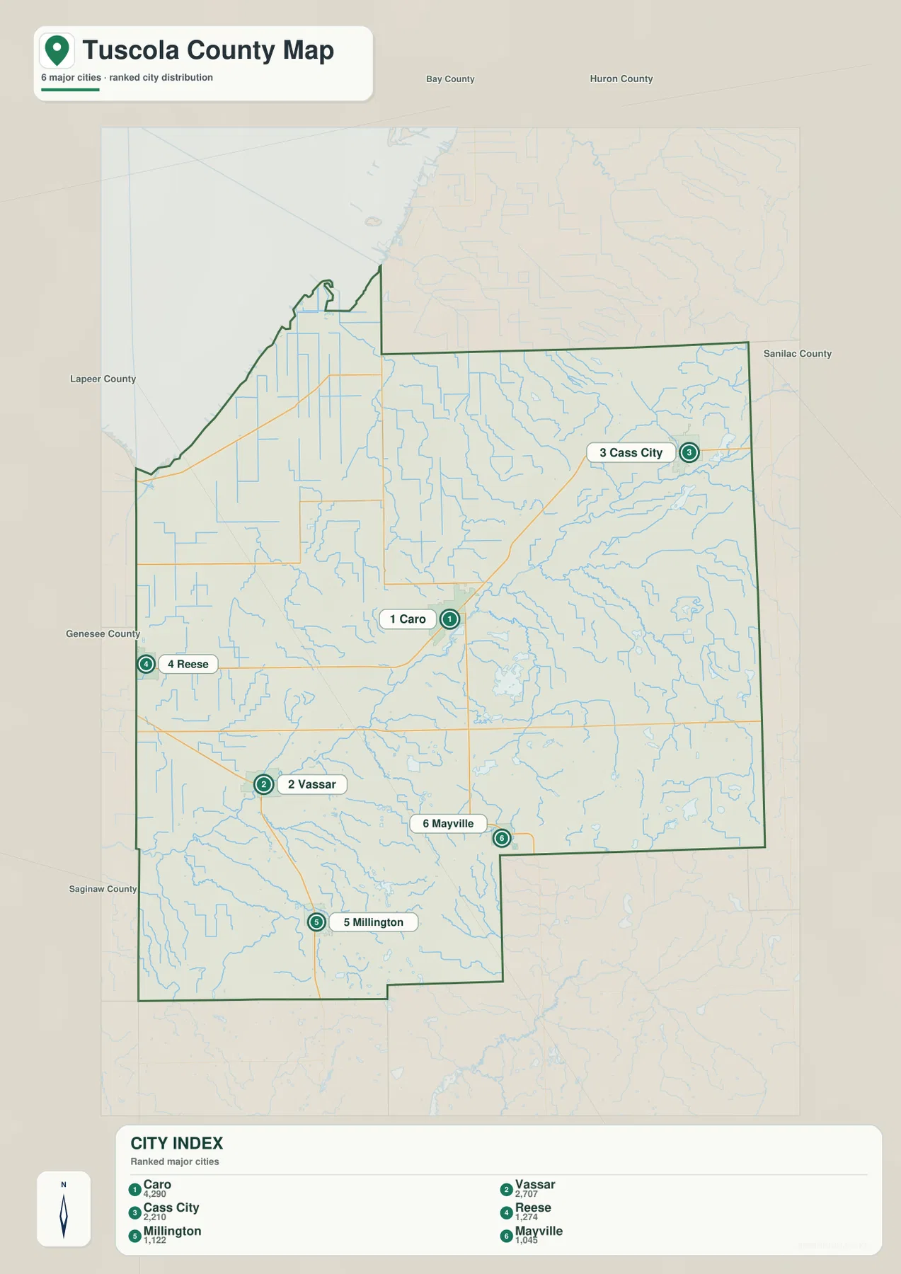
The Cass River is the most prominent named river on the water map. It crosses the central part of the county on a southwest-to-northeast course and is closely associated with the lower terrain around Caro. Numerous smaller channels feed toward the river, giving the central county a much denser drainage pattern than the simplest road map suggests.
Northeast of Caro, Sucker Creek is clearly labeled, and farther east the South Branch White Creek and White Creek Drain extend across the eastern interior. Harmon Lake, Cat Lake, Shay Lake, and Beecroft Lake are scattered through that same broad area. The combination of creeks and small lakes makes the eastern side more varied than the low bay plain in the northwest.
The southwest has its own network. Goodings Creek, Perry Creek, and Millington Creek occupy the Vassar–Millington side of the county, with Murphy Lake and North Lake appearing farther south. Wisner Drain is labeled in the northwest, where a dense pattern of straight drainage channels corresponds with the broad lowland leading toward Saginaw Bay.
Tuscola County Parks and Recreation provides a useful local example of the county’s bay-side geography. Its official page describes Vanderbilt County Park and Campground on the Saginaw Bay shoreline outside Quanicassee near M-25 and Bath Road. That location helps connect the very low northwestern terrain on the elevation map with a real public shoreline site in Tuscola County.
Use the water map for names and broad location relationships, not for flood probability, legal shoreline limits, parcel ownership, navigable depth, or current drain conditions. Those questions require current products from the responsible county, state, or federal agency.
A 176–299 meter range from bay lowlands to southern hills
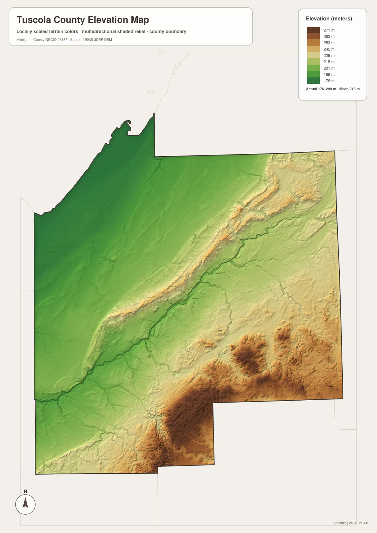
The elevation map reports an actual range of about 176 to 299 meters and a mean near 218 meters. The lowest terrain appears in green across the northwest, especially toward the Saginaw Bay side of the county. Elevation increases toward the center and east, producing a much more textured landscape than the nearly level bay-side plain.
The most distinctive feature is a diagonal band of higher terrain running from the southwest toward the northeast through the middle of the county. This ridge-like zone becomes especially prominent east of Caro and west of Cass City, where tan and brown colors rise above the surrounding river valleys. The Cass River occupies a lower corridor alongside portions of this higher ground.
A second concentration of high terrain appears across the south and southeast. Hills southeast of Millington and around the Mayville side of the county reach some of the darkest brown colors on the map. By contrast, the Vassar-to-Caro western corridor and the broad northwestern plain stay mostly green, making the county’s internal relief easy to compare.
A total difference of roughly 120 meters is modest compared with mountain counties, but it is enough to influence the appearance of river valleys and local road corridors. The layer is intended for county-scale relief comparison only. Surveying, drainage design, construction, or other work requiring precise elevations should use more detailed USGS products and field measurements.
Comparing Caro, Cass City, and Vassar across the map layers
Caro becomes more informative when the layers are viewed together. The general map shows M-81 and M-24 meeting near the city, the water map places Caro close to the Cass River corridor, and the elevation map shows it between lower river terrain and the higher diagonal ridge to the east. Those three details explain why Caro is a useful geographic reference point for the county.
The Cass City side is closer to the higher eastern terrain and the White Creek network, while Vassar and Millington are associated with Goodings Creek, Millington Creek, and the southern hills. Reese and Fairgrove sit in a much flatter western setting where straight roads and drainage channels are more common. These differences make the county feel less uniform than its agricultural road grid might first suggest.
The map set works well for school assignments, local-history presentations, trip preparation, and general county orientation. It does not replace parcel records, zoning documents, flood-regulation products, legal surveys, or real-time transportation information, so specialized decisions should rely on current county, state, or federal sources.
Download the A3 JPG map files
The ZIP below contains the high-resolution A3 JPG originals for the general county map, ranked city index, water map, and elevation map. You can print one file, keep the complete set for reference, or compare Caro, the Cass River corridor, the Saginaw Bay lowlands, and the southern hills across multiple layers.
Frequently Asked Questions
Which maps best explain the difference between Caro and Cass City?
Start with the general county map for roads and relative location, then compare the elevation map. Caro lies close to the lower Cass River corridor, while the route toward Cass City crosses or approaches the higher diagonal terrain in the central-eastern county.
Are the numbers in the city index current population estimates?
The values on this page are copied from the supplied city-index graphic. For the latest population figures, use current U.S. Census Bureau or local-government statistics rather than treating the map values as a new estimate.
Can the 176–299 meter elevation range be used for engineering work?
No. The elevation layer is suitable for broad comparison of higher and lower terrain, but precise construction, drainage, engineering, or survey work requires more detailed official elevation data and field verification.
Map File Information
A ZIP containing the high-resolution A3 JPG originals for the Tuscola County map, city index, water map, and elevation map.
- Included Files: county map, city index map, water map, elevation map
- File Type: JPG
Related Maps
Sources and references
- U.S. Census Bureau TIGER/Line Shapefiles – official geographic files for county boundaries, roads, and place references.
- USGS National Hydrography – federal source for rivers, streams, lakes, and other hydrographic features.
- USGS 3D Elevation Program – official U.S. elevation and terrain data resources.
- Tuscola County official website – county government and local information for Tuscola County, Michigan.
- Tuscola County Parks and Recreation – official information about Vanderbilt County Park and county recreation resources.
Green Map creates custom-edited map images using open geographic data sources such as geoBoundaries, Natural Earth, OpenStreetMap, and government open data. These maps are edited visual materials, not raw data files, and are provided for education, documents, presentations, and graphic reference.