Iosco County sits on Michigan’s northeastern Lower Peninsula, where the Lake Huron shoreline gives the county a very different shape from an inland grid county. East Tawas and Tawas City cluster around Tawas Bay, Oscoda and Au Sable sit farther north near the mouth of the Au Sable River, and Whittemore provides an inland reference well west of the lake. The maps on this page separate those features into roads and settlements, city connections, waterways, and elevation. The same maps are also available as high-resolution JPG files in a downloadable ZIP for printing or closer viewing.
That coastal-versus-inland split is not just a cartographic impression. Iosco County’s own overview notes that much of the population is concentrated along the Lake Huron shore near US-23, East Tawas, Tawas City, and Oscoda, while another concentration lies on the west side of the county. The road map reflects that pattern: US-23 follows the lake, M-55 runs west from Tawas City, and M-65 gives the southwestern interior a north-south reference. Add the water and elevation maps, and the county becomes easier to understand as a set of river valleys, inland lakes, low shoreline terrain, and higher ground toward the west and northwest.
Table of Contents
The Lake Huron edge anchors the county around East Tawas and Tawas City
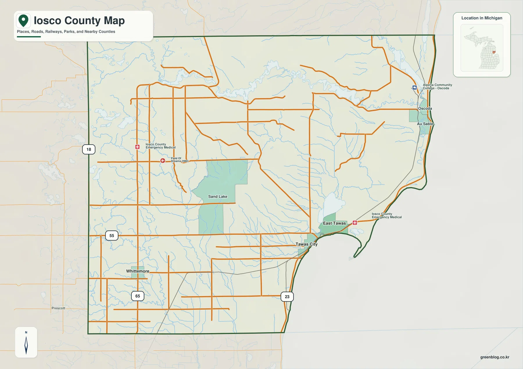
The county map is easiest to orient from the east because Lake Huron forms a long, unmistakable boundary. Oscoda and Au Sable appear near the northeastern shore, while East Tawas and Tawas City sit farther south around Tawas Bay. A narrow hooked projection extends from the southeastern side of the bay. Michigan’s Department of Natural Resources describes Tawas Point as the end of a sand spit that forms Tawas Bay, which explains why the shoreline there bends so sharply instead of following a simple north-south line. This coastal shape is one of the most useful visual clues on the entire map.
Three highways provide a simple framework for the rest of the county. US-23 stays close to Lake Huron and links the coastal communities. M-55 begins at the Tawas area and stretches west across the county toward Whittemore, making it the clearest east-west reference. M-65 crosses the southwestern interior and gives Whittemore a north-south road connection that is separate from the coastal corridor. Numerous local roads fill the spaces between these routes, but starting with US-23, M-55, and M-65 prevents the road network from looking more complicated than it really is.
The map also shows how different the settlement pattern is from one side of the county to the other. East Tawas and Tawas City lie close together along the bay, and Oscoda and Au Sable form another coastal pair farther north. Whittemore is separated from those shoreline communities by a broad interior crossed by streams, wooded land, and smaller roads. Sand Lake appears near the middle of the county as a useful inland landmark. Instead of one dominant city sitting at the geometric center, Iosco County has several practical reference points tied to the shore, river mouth, and western road network.
East Tawas, Tawas City, and Whittemore create two very different location clues
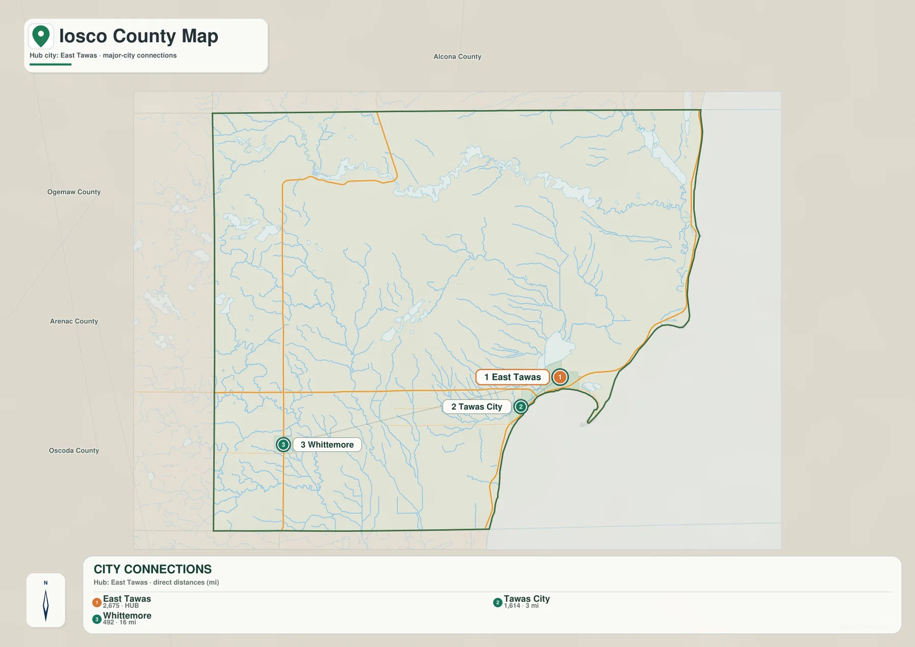
The city-connections map uses East Tawas as its hub and compares it with Tawas City and Whittemore. It labels Tawas City at about 3 miles from East Tawas and Whittemore at about 16 miles. Those numbers are straight-line distances, not driving distances along the road network. They are best used to compare spacing and direction rather than to estimate travel time. The contrast is still useful: Tawas City is a near neighbor on the same bay, while Whittemore is a distinctly inland destination.
East Tawas and Tawas City work almost like a paired reference on small-scale maps because both are tied to Tawas Bay and US-23. Whittemore serves a different role. It lies west-southwest of the bay near the M-55 and M-65 corridors, so it is a much better landmark for the interior. If a place name is unfamiliar, determining whether it is closer to the Tawas shore or the Whittemore side can immediately narrow the search. That is especially helpful in a county where many smaller roads and water features occupy the broad area between the lake and the western boundary.
The city map also includes comparison population figures beside the three places, but those values should not replace current Census data when an up-to-date population count is needed. The more durable information is the spatial arrangement. East Tawas and Tawas City sit within the same coastal zone, while Whittemore marks a shift into the higher inland landscape. The city map therefore works well as a first step before moving to the detailed county, water, or elevation map for a more specific location.
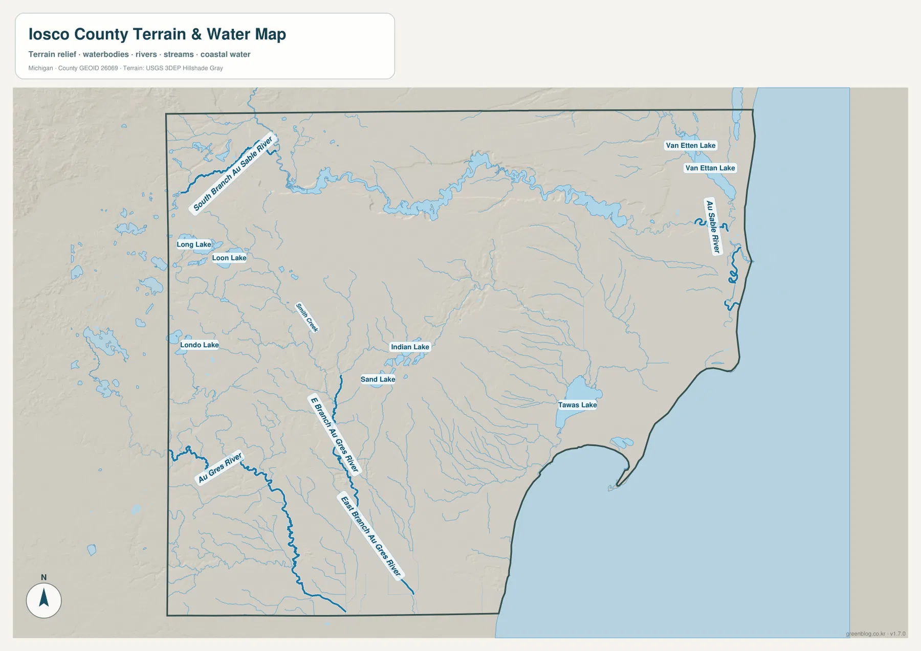
The Au Sable River, Tawas Lake, and inland lakes divide the water story
The most prominent river on the water map is the Au Sable River, which crosses the northern part of Iosco County before reaching Lake Huron near Oscoda and Au Sable. Its broad, winding channel is easy to follow even at a reduced map size. The South Branch Au Sable River approaches from the northwest and joins the larger system, while Van Etten Lake lies near the northeastern part of the county close to the river and shoreline. This combination makes the Oscoda area more than a coastal location; it is also the outlet zone for one of northern Lower Michigan’s major river systems.
Farther inland, the map shifts from one dominant river to a scattered group of lakes and smaller streams. Long Lake, Loon Lake, and Londo Lake sit toward the west. Sand Lake and Indian Lake occupy more central positions and provide useful landmarks away from the main highways. Thin tributaries branch through much of the interior, often following shallow valleys that become more obvious when the elevation map is viewed next. These smaller waters help distinguish places that might otherwise look similar on a road-only map.
Tawas Lake is the most conspicuous inland water body near the southeastern shore. It sits just inland from East Tawas and Tawas City, creating a useful three-part reference with the lake, Tawas Bay, and the two coastal cities. In the southwestern part of the county, the Au Gres River and East Branch Au Gres River belong to a different drainage pattern, while Smith Creek appears among the smaller named streams farther north. The result is not a county drained by one river alone: the northern Au Sable system, southern Au Gres drainage, inland lakes, and short coastal streams all contribute to the map.
This is a geographic reference map, not a flood-risk or navigation product. A blue line confirms the mapped location of a stream or river, but it does not establish current depth, boating access, flood probability, property rights, or safe crossing conditions. Those questions require purpose-specific and current official data. For general orientation, however, the map is especially helpful for tracing the Au Sable River to Lake Huron, locating Tawas Lake behind the bay communities, and separating the inland lake groups from the larger river corridors.
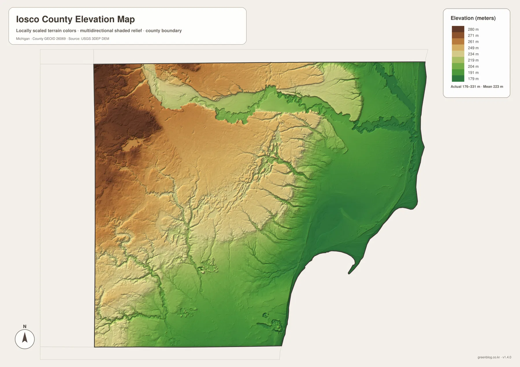
Elevation drops toward Lake Huron while the western interior rises above 300 meters
The elevation map reports an actual mapped range of roughly 176 to 331 meters, with a mean near 223 meters. Green shades represent lower ground and tan to brown shades represent higher terrain within the county. The strongest large-scale pattern runs from east to west: the Lake Huron shore and Tawas Bay area are broadly low, while the western and northwestern interior rises into darker, higher terrain. That contrast makes Iosco County much easier to interpret than a flat road map might suggest.
The Au Sable River creates another major low-elevation feature across the north. A broad green corridor follows the river as it curves east toward Lake Huron, cutting into higher land on both sides. Smaller tributary valleys appear as narrow green fingers extending through the center and south. Near Tawas Bay, low terrain spreads more broadly along the shore, while the western side shows a stronger mix of ridges and shallow valleys. Comparing this surface with the water map explains why the river network takes the shape it does without requiring a long list of contour values.
A 155-meter difference between the lowest and highest mapped values does not make Iosco County a mountain county. The elevation surface is generalized for county-scale comparison, so it is designed to show broad relief rather than the exact height of every road, building site, or parcel. Surveying, drainage design, construction, and other precision work require more detailed elevation data or professional measurements. For ordinary map reading, the key message is clear: the shore and major river valleys are low, and the land generally rises toward the west and northwest.
US-23, M-55, and M-65 make a practical three-road reference
A simple way to use the map set is to decide whether the place of interest belongs to the coast, the east-west interior corridor, or the western north-south corridor. US-23 is the natural starting point for Oscoda, Au Sable, East Tawas, and Tawas City. M-55 is the main cross-county guide from the Tawas area toward Whittemore. M-65 becomes more useful on the western side. Once the correct corridor is identified, smaller local roads and nearby lakes or streams can be used to narrow the position.
The water and elevation maps add context that the road map cannot supply by itself. Around Oscoda, the Au Sable River mouth is as important a landmark as US-23. Around East Tawas and Tawas City, Tawas Bay and Tawas Lake frame the low coastal setting. Farther west, Whittemore sits away from the lake in terrain that generally rises compared with the shore. Sand Lake and Indian Lake provide additional interior reference points. Switching between these maps is often more useful than crowding every road, water name, and elevation detail onto a single image.
For screen viewing, the body images are 1273 × 1800 WebP files chosen for efficient web display. The ZIP contains the original 2572 × 3638 JPG versions, which are better suited to printing or zooming into small labels and stream lines. Use the general county map when roads and settlements matter most, the city-connections map for quick spacing between the three highlighted places, the water map for named rivers and lakes, and the elevation map for the broad contrast between the Lake Huron lowlands and the western high ground.
Frequently Asked Questions
How close are East Tawas and Tawas City on the map?
The city-connections map shows Tawas City about 3 miles from the East Tawas hub in a straight line. Both places sit around Tawas Bay and are linked by the US-23 corridor, so they work well as a paired coastal reference. Driving distance and travel time can differ from the straight-line measurement, so use a current road or navigation service for an actual trip.
Which map is best for following the Au Sable River?
The terrain and water map is the clearest choice because it shows the Au Sable River crossing the northern county, the South Branch Au Sable River, nearby Van Etten Lake, and the river’s approach to Lake Huron. If you also need roads and communities, compare it with the general county map to see the relationship between the river mouth, Oscoda, Au Sable, and US-23.
What files are included in the Iosco County map download?
The ZIP contains four high-resolution JPG files: the general county map, the East Tawas-centered city-connections map, the terrain and water map, and the elevation map. Each image is 2572 × 3638 pixels. The water map is not a flood or navigation chart, and the elevation map is not survey-grade, so specialized decisions should rely on the appropriate current official source.
Map File Information
Download the map files associated with this page for reference, printing, and compatible visual projects.
- Included Files: Use only the versions confirmed in the article and supplied images
- File Type: Use the confirmed download contents
- Intended Use: Printing, education, presentations, and map-based projects
Related Maps
Sources and References
For county background, current statistics, shoreline information, and the source datasets behind boundary, water, and elevation mapping, the following official resources are useful. These maps are designed for county-scale geographic reference, so legal boundaries, flood risk, precise elevations, and other specialized decisions should be checked against the latest purpose-specific agency data.
- Iosco County – About – official overview of the Lake Huron shoreline, settlement pattern, and major road corridors
- Michigan DNR – Tawas Point State Park – official information on the sand spit that forms Tawas Bay and the Lake Huron shoreline
- U.S. Census Bureau QuickFacts: Iosco County, Michigan – current population and county statistics
- U.S. Census Bureau TIGER/Line Shapefiles – county boundary and geographic data
- USGS National Hydrography – rivers, streams, lakes, and other hydrography data
- USGS 3D Elevation Program – elevation data
Green Map creates custom-edited map images using open geographic data sources such as geoBoundaries, Natural Earth, OpenStreetMap, and government open data. These maps are edited visual materials, not raw data files, and are provided for education, documents, presentations, and graphic reference.