Boone County occupies Kentucky’s northern edge where the Cincinnati metropolitan area meets Ohio River bluffs, wooded creek valleys, and older rural communities. Florence, Union, and Walton form the strongest urban corridor on the eastern side, while Burlington remains the county seat farther west. The Ohio River wraps around the northern and western boundaries, and the interior rises into rolling uplands cut by many short tributaries. High-resolution map files are available for download in the section below.
This guide follows Florence, Burlington, Union, Walton, the main highway corridors, the Ohio River and major creeks, and terrain ranging from about 138 to 295 meters. WebP previews are available for quick viewing, and the matching high-resolution JPG files can be downloaded together in one ZIP for printing, classroom work, or offline reference.
Table of Contents
Florence and Burlington serve different roles in the county’s eastern urban corridor
Florence is the largest urban center on the eastern side of Boone County and sits close to the I-71/I-75 corridor. KY 18 provides a direct county reference between Florence and Burlington, while I-275 crosses the northern side through the Hebron and airport area. Union continues the suburban pattern south of Florence, and Walton lies farther south near the Grant County line.
Burlington is the Boone County seat even though it is smaller than Florence. A Kentucky Historical Society marker explains that the county’s first court selected Craig’s Camp as the seat in 1799, and that the later town at the Woolper Creek site was renamed Burlington in 1816. County courts, clerk functions, and the historic courthouse area remained centered there.
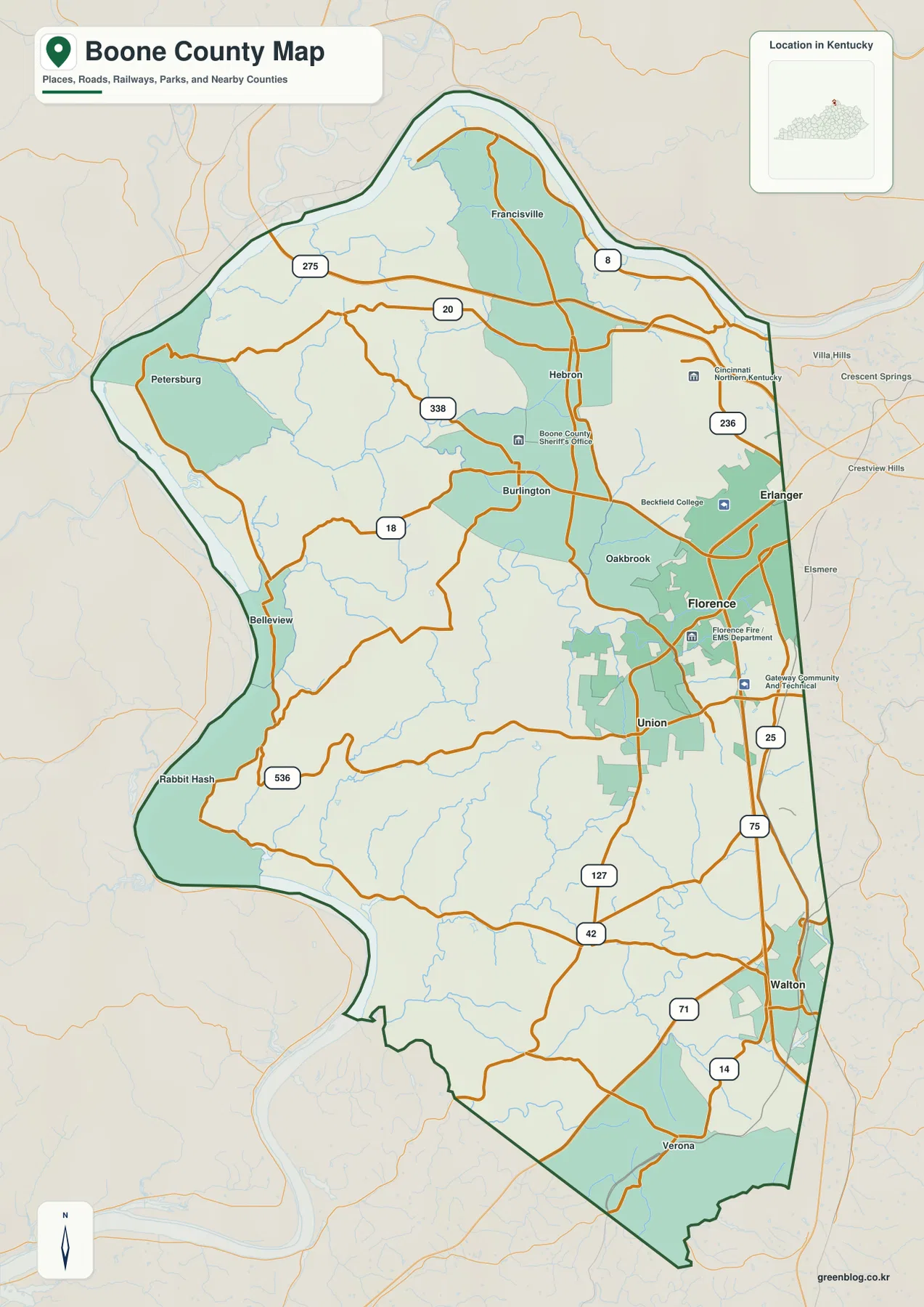
Petersburg, Belleview, and Rabbit Hash provide western Ohio River references, while Hebron and Francisville sit closer to the airport and northern suburban development. Verona and Walton anchor the southern side. The county changes quickly from dense metropolitan development to wooded ravines, river roads, and farmland.
The city-connections panel uses Florence as the hub for Union and Walton
The supplied city-connections panel places Florence at an index value of 32,803, Union at 7,642, and Walton at 5,730. These are map index values rather than current official population estimates. The panel also labels Union at about 3 miles and Walton at about 8 miles in straight-line distance from Florence; those numbers are not driving distances.
Florence and Union form a closely connected suburban area, while the landscape becomes more rural toward Walton. North of Florence, roads lead toward Burlington, Hebron, Erlanger, and the I-275 corridor. South of Union, US 42 and US 127-related routes continue through rolling interior terrain.
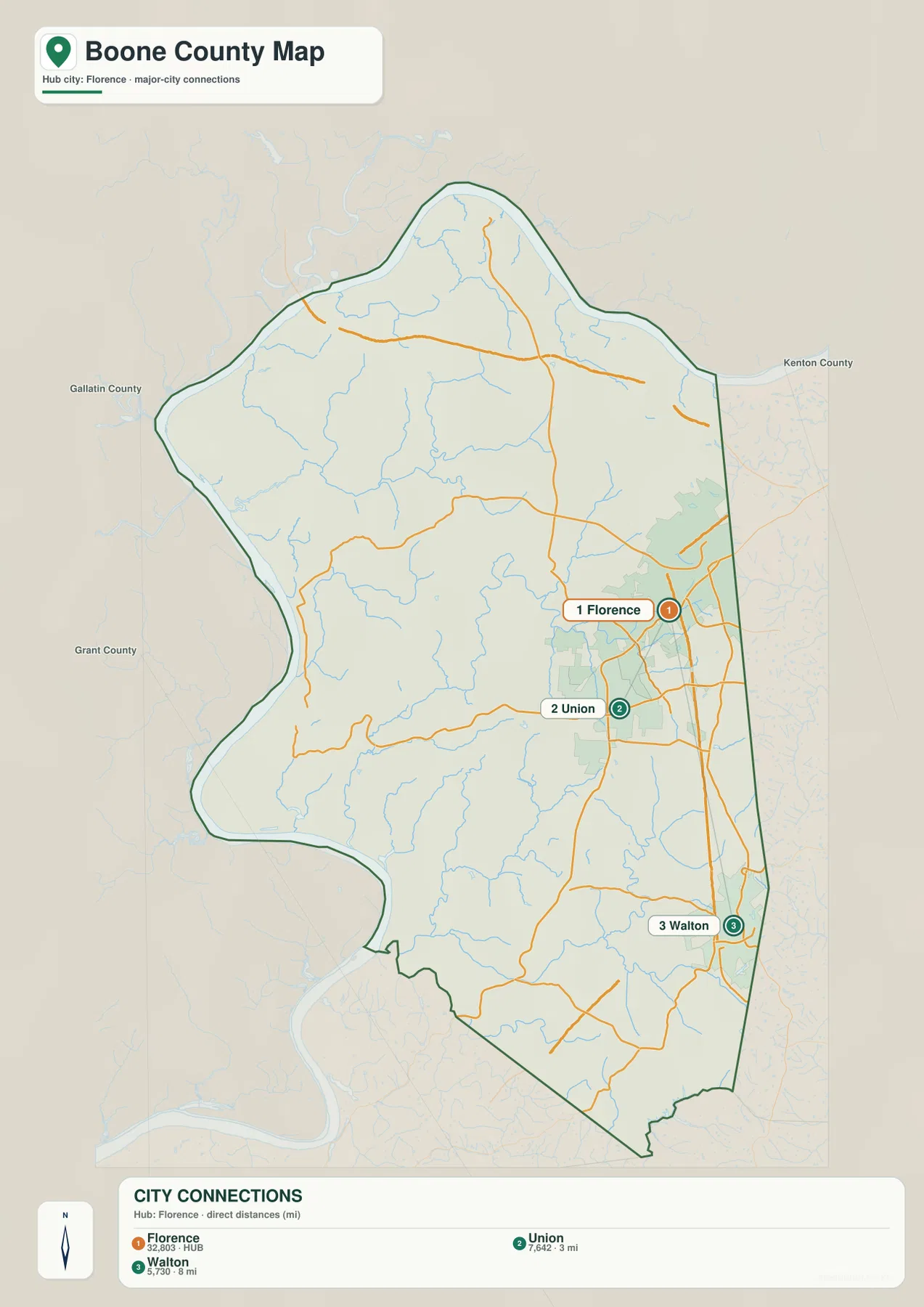
The panel is not a complete table of every important Boone County community. Burlington is the county seat but does not appear among the ranked cities, and places such as Hebron, Petersburg, and Rabbit Hash are shown only on the general county map. Administrative role, city index, and settlement pattern therefore need to be read separately.
The Ohio River defines the outer edge while creeks carve the interior hills
The Ohio River is the county’s dominant natural boundary. It bends around the north, west, and southwest, creating long low corridors at the base of steeper interior slopes. Numerous creeks descend from the uplands and enter the river along the county’s western side.
Garrison Creek and Sand Run drain the northwest, while Woolper Creek and Easton Creek cut through the north-central uplands. Middle Creek creates a pronounced western valley, and Gunpowder Creek runs through the central county with many small tributaries. These waterways reveal a much more dissected landscape than the road network alone suggests.
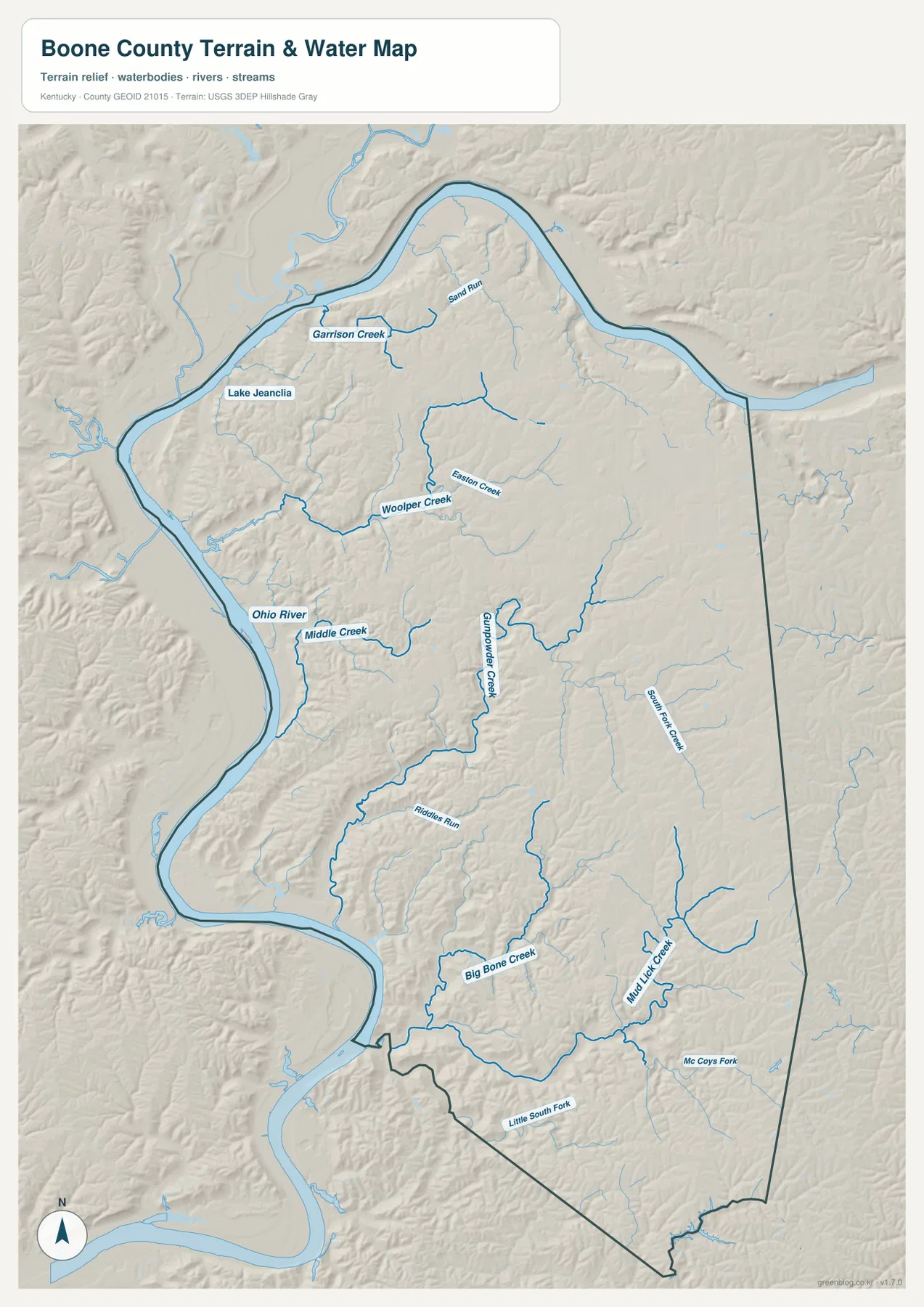
Big Bone Creek drains the southwestern side toward the Ohio River, while Mudlick Creek and McCoys Fork divide the southern uplands. Big Bone Creek is especially important because it runs through the landscape associated with Big Bone Lick State Historic Site.
This image is intended for geographic reference rather than floodplain, navigation, water-quality, parcel, or legal-access decisions. River and creek conditions can change, so current official information should be used whenever water levels, safety, or access matter.
Elevation from 138 to 295 meters separates river bottoms from the higher eastern uplands
The elevation surface ranges from about 138 to 295 meters, with a mean near 229 meters. Green low terrain follows the Ohio River around the western and northern perimeter, while tan and brown uplands become more extensive toward the central and eastern interior.
Creeks cut long narrow low corridors from the uplands toward the river. Middle Creek and Gunpowder Creek are especially clear examples, with steeply rising side slopes and short ridges between neighboring tributaries. Florence, Union, and Walton occupy generally higher interior terrain than the river settlements.
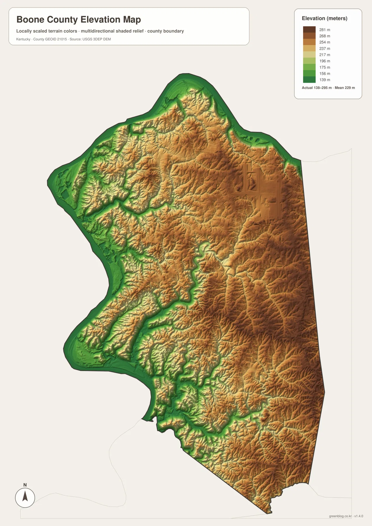
Boone County’s official architectural survey places the county in Kentucky’s Outer Bluegrass region and explains how early settlement followed the river and creek valleys before later rail and highway development shifted growth toward the east. The relief image provides useful physical context for that long transportation history.
The elevation surface is generalized for county-scale comparison. It is not survey-grade or engineering-grade measurement and should not be used for parcel elevations, construction grades, drainage design, or legal boundary work.
Big Bone Lick connects the creek landscape with Ice Age fossils and early exploration
Big Bone Lick State Historic Site is one of Boone County’s most distinctive natural and historical places. Kentucky State Parks describes active salt springs, Pleistocene fossil discoveries, a museum and interpretive trail, and a modern bison herd. Mammoth, mastodon, ground sloth, and other large Ice Age animal remains have been found in the area.
Kentucky Historical Society markers also record the long scientific interest in Big Bone Lick. Thomas Jefferson supported fossil collection there, and William Clark supervised a major dig in 1807. Reading the Big Bone Creek location on the water map helps connect that history with the low, spring-fed landscape where animals and people repeatedly gathered.
CVG Airport gives the Hebron area a major regional transportation role
Cincinnati/Northern Kentucky International Airport, or CVG, is located in the Hebron area of Boone County. The airport’s official directions give a Hebron terminal address and place the airport about 13 miles south of downtown Cincinnati, with access from I-275 and KY 212.
Although the airport carries Cincinnati in its name, its physical location is in Boone County. That makes the northeastern county very different from the rural western side: airport facilities, freight operations, suburban development, and the I-275 corridor sit close to Florence and Hebron, while Ohio River communities remain far less urban.
Boone County Cliffs preserves a steep Middle Creek tributary valley
Boone County Cliffs State Nature Preserve protects a small but unusually rugged landscape in western Boone County. A Kentucky Energy and Environment Cabinet brochure describes the preserve as roughly 74 acres along a Middle Creek tributary, with conglomerate cliffs rising about 20 to 50 feet above the valley slopes.
The preserve is also notable for glacial deposits that are unusual in Kentucky. Its steep valley setting matches the relief map, where Middle Creek and neighboring tributaries cut sharply into the higher interior before descending toward the Ohio River.
Travel west from Burlington and Florence reveals a rapid shift from suburbs to river hills
Burlington and Florence sit within a broad network of roads, neighborhoods, businesses, and public facilities. Moving west toward Petersburg or Rabbit Hash reduces road density and brings creek valleys and ridges into much stronger focus. Near the Ohio River, elevation drops sharply and small communities follow the bends of the river corridor.
Travel south from Florence through Union toward Walton follows a different pattern, staying on higher interior uplands with more continuous suburban and rural development. Turning southwest toward Big Bone Creek leads back into a more natural landscape of valleys, historic sites, and river-country terrain.
For posters, classroom prints, or presentation slides, use the original JPG files in the download archive rather than enlarging the web previews. Small road labels, creek names, city-connection text, and the elevation legend remain clearer at the higher resolution.
Frequently Asked Questions
Are the 32,803, 7,642, and 5,730 values current populations?
No. Florence 32,803, Union 7,642, and Walton 5,730 are map index values supplied with this package. They are separate from current official population statistics. The roughly 3-mile and 8-mile labels are straight-line map distances from Florence, not driving distances.
Why is Burlington the county seat if it is not ranked on the city panel?
The city-connections panel is a selected comparison of major communities rather than a list of administrative centers. Burlington remains the Boone County seat even though it is not one of the three ranked cities on this package, so the general county map and historical sources provide the correct civic context.
Can the 138–295 meter elevation image be used for surveying?
No. It is a generalized county-scale terrain image for comparing low Ohio River bottoms with higher interior uplands and creek valleys. Parcel elevations, engineering grades, drainage design, and legal boundary work require more precise official data and, where needed, professional surveying.
Map File Information
The archive contains the Boone County, Kentucky general county map, city-connections map, terrain-and-water map, and elevation map as original high-resolution JPG files.
- Included Files: Use only the versions confirmed in the article and supplied images
- File Type: Use the confirmed download contents
- Intended Use: Printing, education, presentations, and map-based projects
Related Maps
Sources and references
- Kentucky Historical Society: From Craig’s Camp to Burlington — county-seat history
- Kentucky State Parks: Big Bone Lick State Historic Site — fossils, salt springs, bison, and park information
- CVG Airport: Directions & Traffic — Hebron airport location and I-275 access
- Kentucky Energy and Environment Cabinet: Boone County Cliffs — preserve, cliffs, and glacial deposits
- Boone County: Comprehensive Architectural Survey — county history, Burlington, river towns, and Outer Bluegrass context
- USGS 3D Elevation Program — elevation and terrain reference data
Green Map creates custom-edited map images using open geographic data sources such as geoBoundaries, Natural Earth, OpenStreetMap, and government open data. These maps are edited visual materials, not raw data files, and are provided for education, documents, presentations, and graphic reference.