Bourbon County lies in Kentucky’s Bluegrass region, with Paris serving as the county seat and the clearest road hub. Millersburg, North Middletown, Bunker Hill, and scattered farm communities sit among rolling pastureland cut by Stoner Creek, the South Fork Licking River, and many smaller tributaries. US 27 and US 68 meet in Paris, while KY 32, KY 57, KY 227, KY 353, KY 460, KY 537, and KY 627 spread into the surrounding countryside.
The WebP previews below make it easy to compare towns, roads, streams, and elevation at a glance. The same maps are also available as high-resolution JPG files in the download ZIP, which is better suited to printing, classroom use, or close inspection of route and creek labels.
Table of Contents
Paris makes the best reference point for roads, government, and nearby farm communities
Paris sits just west of the county’s center and gathers the strongest road network in one place. US 27 runs north–south, US 68 crosses the Bluegrass countryside, and KY 627 passes through the same urban area. KY 227 and KY 353 lead west toward Scott County, KY 32 reaches Millersburg and the Harrison County side, and KY 57 and KY 537 serve the eastern countryside around Bunker Hill and Cane Ridge.
The City of Paris history page traces the community back to the late eighteenth century, when it was first known as Hopewell. The town name changed to Paris in 1790, and the Bourbon County courthouse remains in Paris today. That continuity helps explain why the same place still functions as both the civic center and the most useful road reference on the county map.
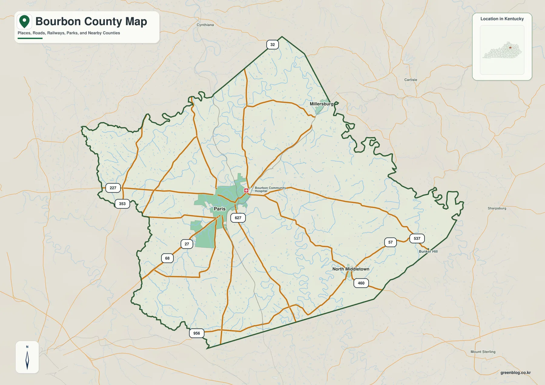
Neighboring places such as Cynthiana, Carlisle, Sharpsburg, and Mount Sterling help position Bourbon County within the larger Bluegrass region northeast of Lexington. Outside Paris, development thins quickly and the map becomes a network of farm roads, creek crossings, and small communities separated by pastureland.
Millersburg and North Middletown sit in the same distance ring but on different sides of the drainage divide
The supplied city panel places Paris at an index value of 10,160, Millersburg at 819, and North Middletown at 679. These are map index values rather than current official population estimates. Both smaller places are labeled at roughly 10 miles in straight-line distance from Paris, which should not be confused with driving distance.
Millersburg lies northeast of Paris near KY 32 and US 68 and is closer to the South Fork Licking River and Hinkston Creek. North Middletown sits southeast along the KY 460 side, where Stoner Creek, Strodes Creek, and smaller tributaries break the countryside into rolling ridges. Similar distance from Paris does not mean similar terrain.
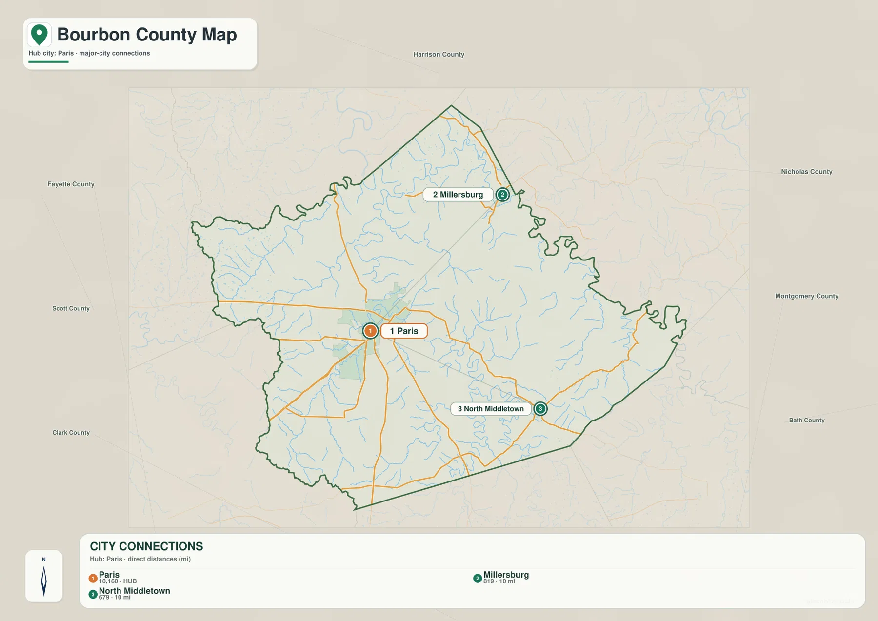
The panel is most useful as a quick way to understand spacing between the county’s main named communities. Paris remains the clear service and government center, while Millersburg and North Middletown function as smaller rural places within different parts of the county.
Stoner Creek crosses the heart of the county while the South Fork Licking River forms the northern lowland
Stoner Creek is the strongest interior water feature, passing near Paris and continuing through the central and southeastern county. Strodes Creek, Boone Creek, Brush Creek, Kennedy Creek, and other tributaries feed the same rolling landscape. Their valleys are not broad enough to dominate the county, but they repeatedly interrupt the uplands and influence the locations of roads, bridges, and farm fields.
Farther north, the South Fork Licking River creates a wider low corridor. Hinkston Creek joins the northern drainage system, while Townsend Creek and Houston Creek cut the western side toward Scott County. Following these names on the map makes the rural road pattern much easier to understand.
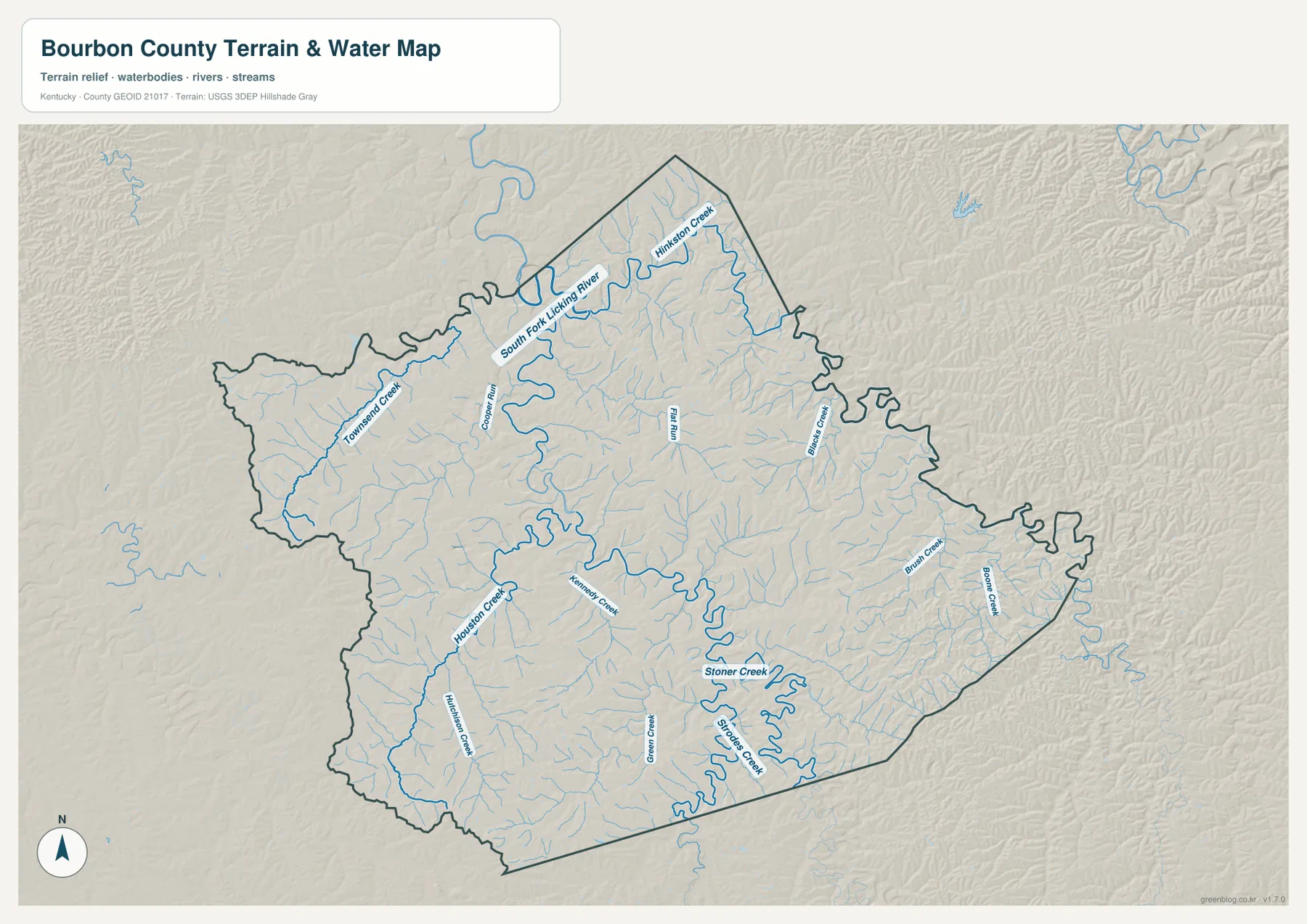
The USGS operates a monitoring location on Stoner Creek at Paris, which provides a current-data reference for that stream. The map on this page is only for geographic orientation; it is not a flood-risk, water-quality, property-boundary, or navigation product, and current water conditions should be checked with official agencies when they matter.
A 171–319 meter range creates the rolling relief associated with Bluegrass horse country
The elevation surface ranges from about 171 to 319 meters, with a mean near 271 meters. Bourbon County is not mountainous, but the difference between low stream valleys and higher pasture ridges is enough to produce the gently rolling terrain seen across the Bluegrass region. The South Fork Licking River stands out as a lower northern corridor, while higher ground is more common in the south and east.
Paris also sits within this rolling surface rather than on a completely flat plain. Stoner Creek and its tributaries cut shallow valleys around the city, while Townsend Creek and Houston Creek divide the western uplands. The same small-scale relief continues toward North Middletown and Cane Ridge.
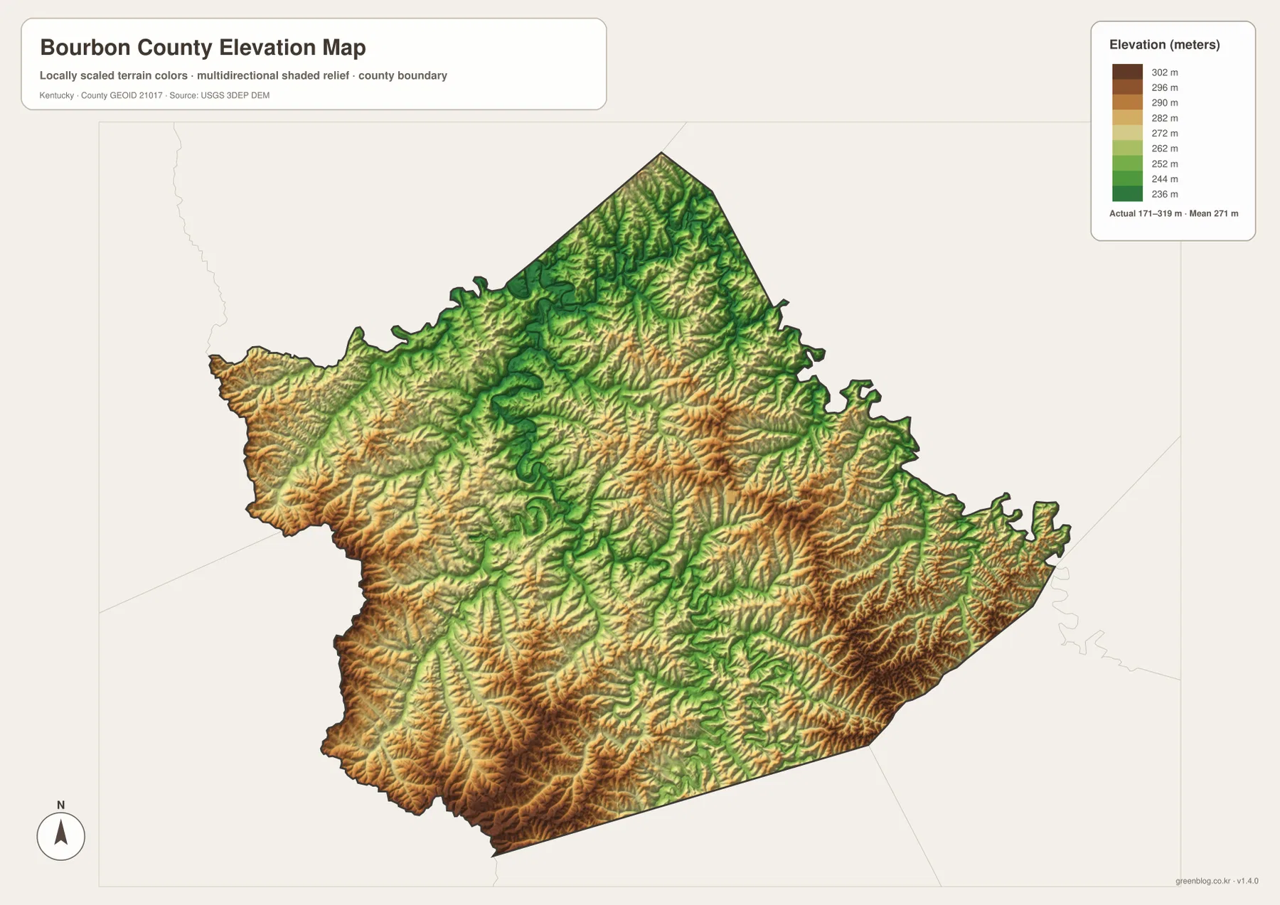
Paris Bourbon County Tourism highlights stone fences, Paris Pike, and Thoroughbred farms as signature scenery. Those features fit the terrain shown here: broad pasture slopes, short ridges, and creek bottoms rather than steep mountains. The elevation map helps explain why the county looks open and agricultural while still having frequent bends and grade changes along rural roads.
This elevation image is generalized for county-scale comparison. It is not suitable for survey, engineering, parcel, drainage-design, or legal-boundary work, all of which require more precise official data and professional measurements where appropriate.
Cane Ridge adds early Kentucky religious history to the farm country east of Paris
The Kentucky Historical Society identifies Cane Ridge Meeting House as a structure built in 1791 and the site of the large 1801 revival. The site lies about six miles east of Paris along KY 537, in the same rural landscape shown around Bunker Hill and the eastern tributaries.
That setting is useful context because Bourbon County is often associated first with horse farms and Bluegrass scenery. Cane Ridge shows that the same rolling countryside also preserves important early Kentucky settlement and religious history.
Thoroughbred farms give the Paris countryside a distinctive local identity
Paris Bourbon County Tourism promotes more than 50 horse farms in the county and features Claiborne Farm among the best known. Claiborne lies in the farm country north of Paris and is closely associated with American Thoroughbred breeding, including Secretariat’s retirement and burial there.
Individual farm boundaries are not drawn on the county map, but the open spaces between Paris, Millersburg, and North Middletown match the pasture landscape for which Bourbon County is known. Stone fences, curving farm roads, and shallow creek valleys make the county feel different from a generic rural grid.
Leaving Paris in different directions quickly changes the balance between creek valley and upland pasture
Northeast toward Millersburg, the route moves closer to Hinkston Creek and the South Fork Licking River, where lower ground becomes more prominent. Southeast toward North Middletown, Stoner Creek and Strodes Creek cut a tighter sequence of rolling ridges.
Westbound routes on KY 227 and KY 353 cross the Townsend Creek and Houston Creek country. East on KY 57 and KY 537, the landscape leads toward Cane Ridge and the Brush Creek–Boone Creek side. Bourbon County does not need dramatic mountains or a large reservoir to have strong geographic differences; small streams and repeated pasture ridges are enough to shape roads, farms, and settlement.
For posters, classroom prints, or presentation slides, use the original JPG files in the download archive rather than enlarging the web previews. Small route labels, creek names, city-connection text, and the elevation legend remain clearer at the higher resolution.
Frequently Asked Questions
Are the 10,160, 819, and 679 values current populations?
No. Paris 10,160, Millersburg 819, and North Middletown 679 are map index values supplied with this package. The roughly 10-mile labels are straight-line map distances from Paris, not driving distances or current official population estimates.
Why do Millersburg and North Middletown look different even though both are about 10 miles from Paris?
Millersburg is closer to the South Fork Licking River and Hinkston Creek lowlands, while North Middletown sits among the Stoner Creek and Strodes Creek hills. The straight-line distances are similar, but the two places occupy different drainage settings.
Can the 171–319 meter elevation image be used for surveying?
No. It is a generalized county-scale terrain image for comparing lower river and creek valleys with higher Bluegrass uplands. Parcel elevations, engineering grades, drainage design, and legal boundary work require more precise official data and, where needed, professional surveying.
Map File Information
The archive contains the Bourbon County, Kentucky general county map, city-connections map, terrain-and-water map, and elevation map as original high-resolution JPG files.
- Included Files: Use only the versions confirmed in the article and supplied images
- File Type: Use the confirmed download contents
- Intended Use: Printing, education, presentations, and map-based projects
Related Maps
Sources and references
- Bourbon County, Kentucky official site — county government and courthouse information in Paris
- City of Paris: History of Paris — early Paris and Bourbon County history
- Kentucky Historical Society: Cane Ridge Meeting House — 1791 meeting house and 1801 revival history
- Paris Bourbon County Tourism — horse farms, Paris Pike, and local visitor information
- USGS Water Data: Stoner Creek at Paris — stream monitoring reference in Paris
- USGS 3D Elevation Program — elevation and terrain reference data
Green Map creates custom-edited map images using open geographic data sources such as geoBoundaries, Natural Earth, OpenStreetMap, and government open data. These maps are edited visual materials, not raw data files, and are provided for education, documents, presentations, and graphic reference.