Barry County in southwestern Michigan is organized around Hastings, a central city where several state routes meet, while the Thornapple River system shapes much of the northern and central landscape. Middleville, Freeport, Woodland, and Nashville occupy different edges of the county, and the southern half contains many small lakes set among rolling hills. Those changes in roads, water, and relief make the county more varied than its fairly regular boundary suggests.
This page separates the main geographic information into a road-and-place map, a hub-and-community connection map, a terrain-and-water map, and an elevation map. High-resolution JPG originals are available together in a ZIP download for printing, classroom materials, presentations, and detailed local reference. The browser images are useful for quick viewing, while the downloadable files provide more detail when a larger image is needed.
Hastings provides the easiest starting point for orientation. M-37 runs through the central part of the county, M-43 reaches toward the southwest, and M-79 links Hastings with Nashville to the east. North of Hastings, the Thornapple River and its branches spread across lower terrain, while the south becomes more lake-filled and generally higher.
Table of Contents
Hastings anchors the M-37, M-43, and M-79 road network
The general county map makes Hastings the clearest road reference. M-37 runs north and south through the central area, while M-43 and M-79 extend the network toward the west and east. Because several routes meet near Hastings, the city works well as a starting point for locating Middleville in the northwest, Nashville near the eastern boundary, and Delton in the southwest.
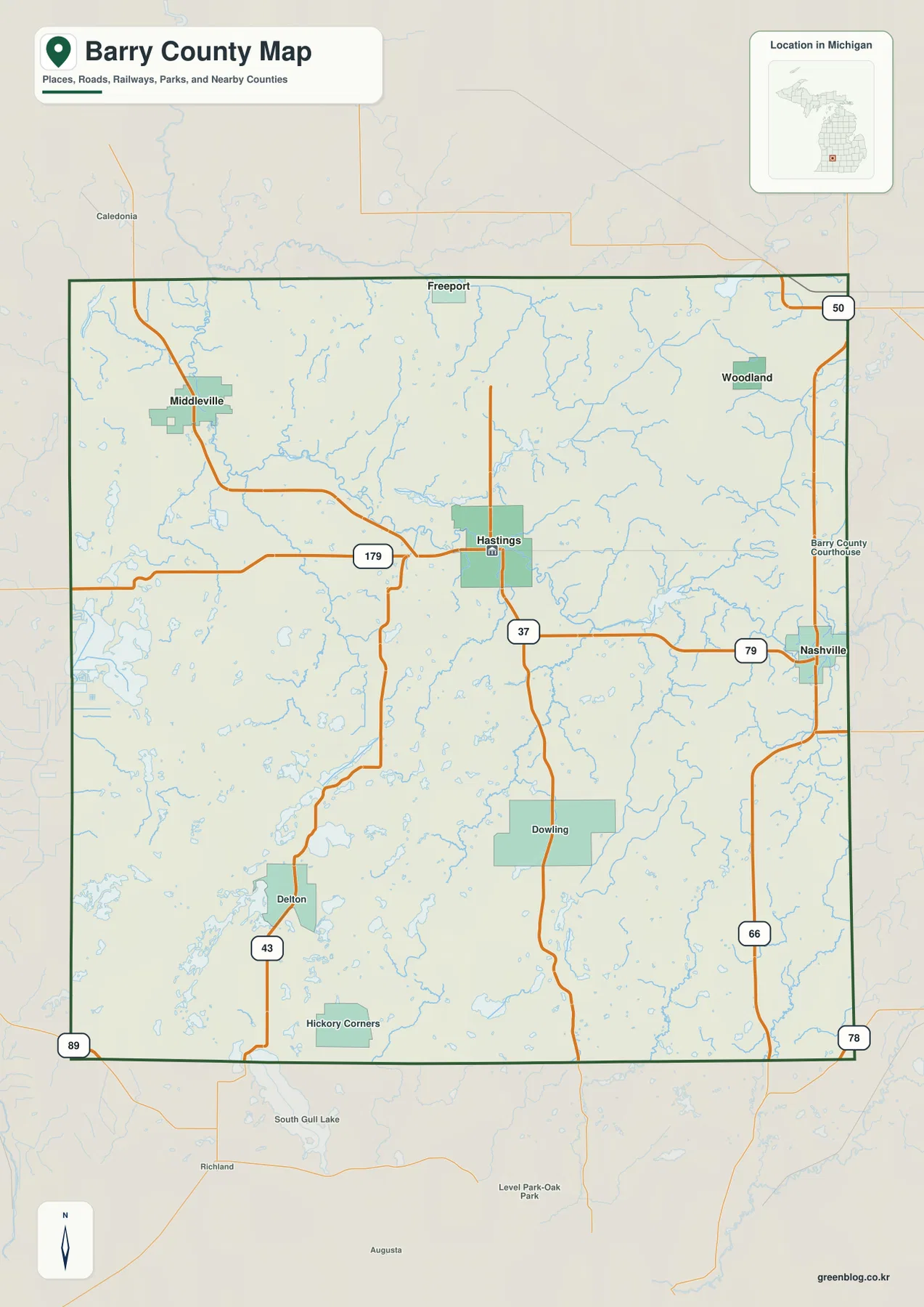
Middleville sits in the northwestern part of the county, connected southward toward Hastings and northward toward nearby communities outside the county. Freeport lies close to the northern boundary, while Woodland is farther east in the northeast. Their placement shows that the county’s northern communities are spread across a wide east-west span rather than clustered around one road.
Nashville stands near the eastern edge and is most easily related to Hastings through M-79. South of Nashville, M-66 continues as a strong north-south reference, while M-50 appears near the northeastern edge. These routes show how Barry County connects with neighboring areas as well as how its own eastern communities relate to the central county seat.
The southwest looks different. Delton and Hickory Corners sit in an area where small lakes are much more common, and M-43 becomes the most useful route for orientation. Roads bend around water and rolling terrain, so the network appears less direct than the straighter sections near the county’s eastern edge. The general map is particularly useful here because roads and lakes can be viewed together.
The Barry County Courthouse label reinforces Hastings as an administrative center as well as a transportation reference. The map is intended for regional orientation and does not include live traffic, construction, or seasonal road closures. Anyone using it for travel should pair it with current Michigan transportation or navigation information.
Hastings connects to Middleville, Nashville, Freeport, and Woodland
The community-connection map simplifies the county and places Hastings at the hub. Middleville appears to the northwest, Freeport to the north, Woodland to the northeast, and Nashville to the east. By reducing small roads and local labels, the map makes direction and spacing easier to compare than they are on the full county view.
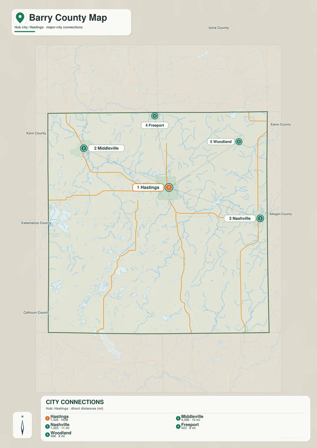
Middleville and Hastings form a useful northwest-to-center comparison. The full road map shows that their connection passes through an area crossed by streams and secondary roads, while the simplified map removes those details and emphasizes the overall direction. It is a good example of why both versions are useful for different purposes.
Freeport and Woodland are both in the northern part of the county, but they occupy different positions. Freeport sits closer to the north-central boundary, while Woodland is farther east. The distinction matters when comparing river branches, because the northern drainage network spreads across much of the county rather than following one single corridor.
Nashville is the only highlighted place clearly east of Hastings. M-79 explains the connection on the general map, while the hub view reduces the relationship to a simple eastward line. For presentations, classroom handouts, or quick orientation, that cleaner arrangement can be easier to read than a map filled with smaller roads and water features.
This is not a complete settlement inventory. Delton, Dowling, Hickory Corners, and other named places on the general map are omitted because the purpose is to show selected connections from Hastings. Use the full county map for a broader place reference and the connection map when relative direction among the highlighted communities is the main question.
The Thornapple River system links northern valleys with lakes and smaller streams
The terrain-and-water map makes the Thornapple River the dominant feature in the northern half of Barry County. North Branch Thornapple River is labeled near the north-central area, and Little Thornapple River reaches toward Jordan Lake in the northeast. The main Thornapple River crosses the county through a broad network of tributaries that is much easier to see without the heavier road labeling.
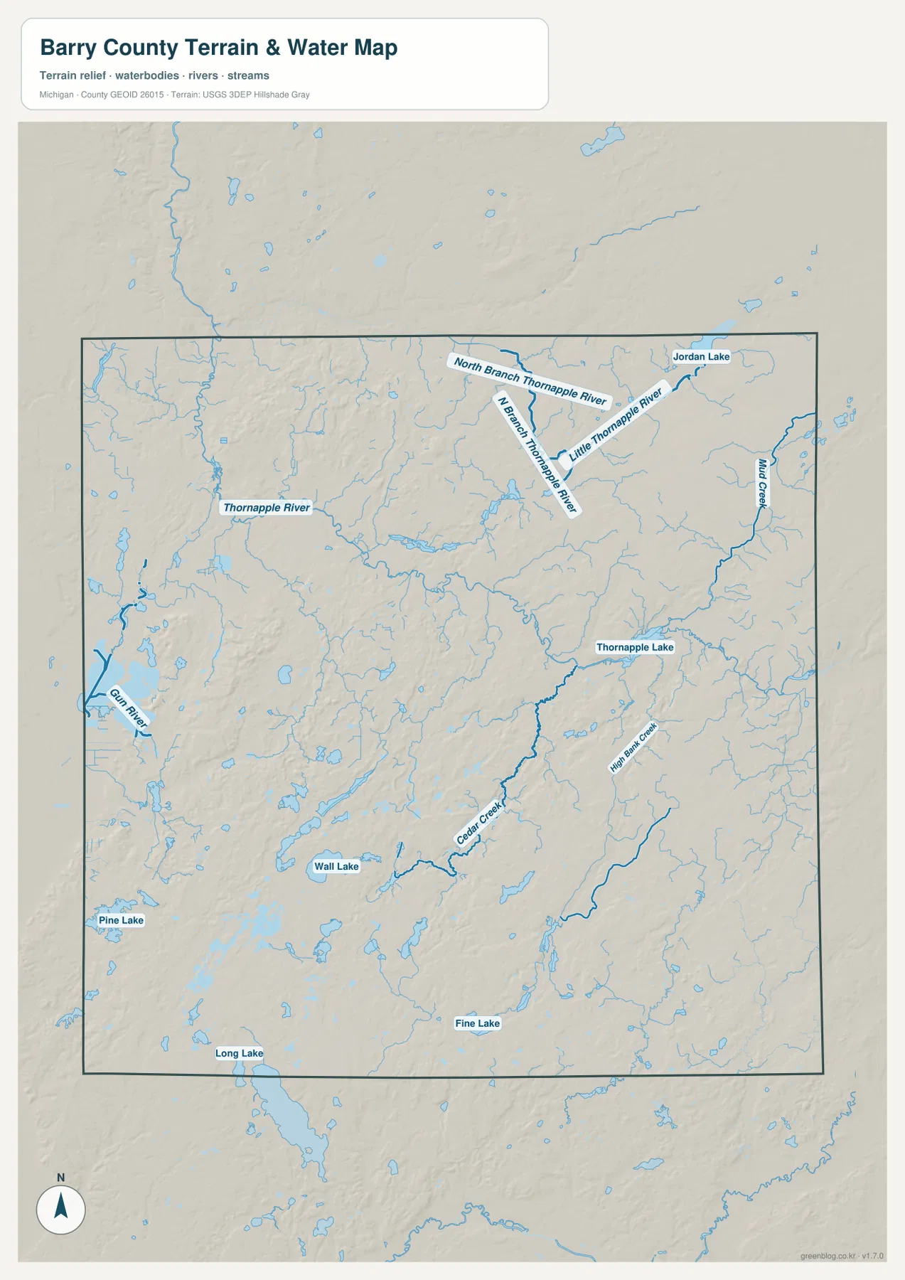
Jordan Lake lies near the northeastern side, with Little Thornapple River and Mud Creek nearby. Farther south and west, Thornapple Lake occupies a central-eastern position along the larger drainage area. These features line up closely with lower terrain on the elevation map, which helps explain why the river network follows broad green valleys through the otherwise rolling county.
Gun River is labeled on the western side, while Cedar Creek and High Bank Creek appear farther south and east. These smaller waterways are important because they show that the county is not drained by one simple channel. Water reaches the Thornapple system through many tributaries, wetlands, and small valleys that spread across both the central and southern portions.
The southern half is especially notable for scattered lakes. Wall Lake, Pine Lake, Long Lake, and Fine Lake are among the named examples, and many additional small water bodies appear around them. Instead of forming one continuous chain, the lakes occupy depressions among rolling hills, particularly around the Delton and Hickory Corners side of the county.
The water map is designed for geographic reference, not for boating or flood decisions. It does not show depth, current speed, water quality, legal access, navigability, or flood zones. Fishing, paddling, flood planning, and other regulated activities should use current Michigan and federal information in addition to this county-scale map.
Low Thornapple valleys give way to higher rolling terrain in the south
The elevation map removes road and town labels and uses locally scaled colors with shaded relief. Its legend reports an actual elevation range of about 213 to 343 meters and a mean of 269 meters. Dark green marks the lower parts of Barry County, lighter green and yellow indicate middle elevations, and brown represents higher ground. Because the palette is scaled to this county, the same color on another county map should not be treated as the same height.
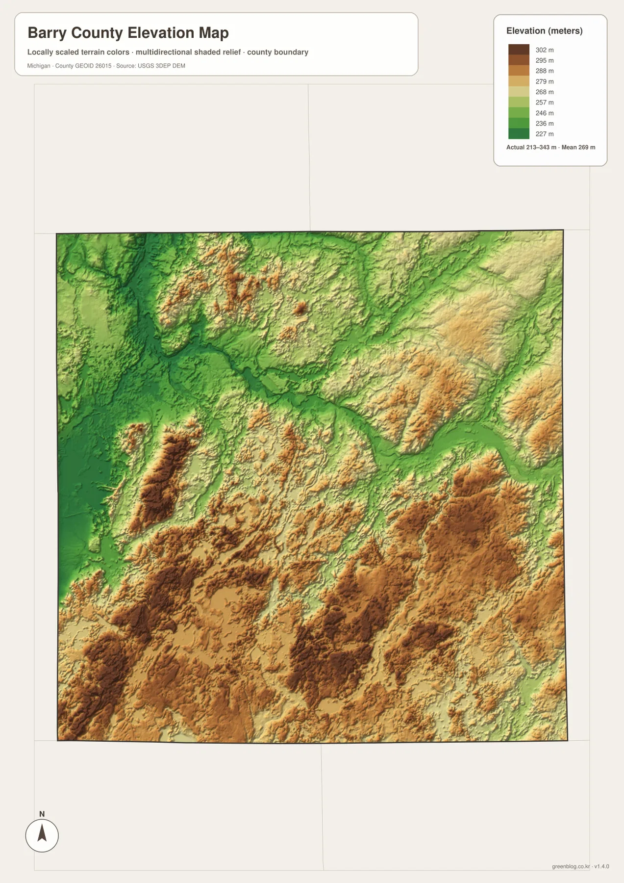
The lowest dark-green terrain follows river valleys across the northern and central parts of the county. The Thornapple River and its northern branches align closely with these low corridors, and a broad green band extends through the Hastings area toward the east. Comparing this image with the water map makes the relationship between drainage and relief immediately visible.
Warmer colors become more common toward the south. Large areas of yellow, orange, and brown cover the south-central and southeastern portions, and strong relief shading reveals repeated ridges and depressions rather than a flat plateau. The higher ground is especially noticeable where it surrounds lower stream channels and small lakes.
The northwest also contains locally high ridges, particularly around areas south and west of Middleville. Those higher patches sit close to the lower Thornapple corridor, creating abrupt changes over relatively short distances. Barry County therefore cannot be summarized as a simple north-to-south slope; the broad trend is interrupted by river valleys and isolated uplands.
Southern lakes such as Wall Lake, Long Lake, and Fine Lake occupy lower pockets within this hillier terrain. The elevation colors dip around several water bodies and stream courses, while adjacent ridges rise into yellow or brown. This helps explain why roads in the lake district often curve between water and higher ground instead of crossing the landscape in straight lines.
This elevation surface is a generalized county-scale reference and should not be used as a survey. Exact parcel elevations, construction slopes, drainage design, engineering decisions, and other precision work require authoritative detailed data such as the USGS 3D Elevation Program rather than estimates from the color ramp.
Reading Hastings, the Thornapple valleys, and the southern lake country together
Hastings shows how the map types complement one another. The general map emphasizes M-37, M-43, and M-79 around the central city. The connection map then shows how Middleville, Freeport, Woodland, and Nashville are positioned around Hastings, while the water map adds the Thornapple River and nearby tributaries. The elevation map completes the picture by showing that much of this river corridor occupies lower ground.
Middleville provides a useful northwest example. The road map shows its connection toward Hastings, while the water map places it near the Thornapple drainage. The elevation view adds nearby higher ridges beside the lower river corridor. Those pieces together make the road pattern easier to understand than a single map would.
Nashville sits in a different setting. M-79 connects it westward with Hastings, and M-66 provides another orientation line nearby. The elevation map shows higher terrain developing to the south and southeast, while the northern drainage network becomes less dominant. This creates a clear contrast with Woodland and the low river corridors farther north.
Delton and Hickory Corners are best understood by starting with water. Numerous small lakes appear in the southwest, and the elevation map shows them sitting among ridges and lower depressions. Returning to the road map then clarifies how M-43 and local roads pass through a landscape shaped by both water and rolling terrain.
For practical use, the general map is strongest for named roads and places, the connection map for quick direction between selected communities, the water map for rivers and lakes, and the elevation map for low valleys and higher hills. Comparing the same part of Barry County across the four views gives a more complete geographic picture without crowding every detail onto one page.
Choosing a Barry County map and using the downloadable files
Start with the general county map when you need roads and place names. Hastings, Middleville, Nashville, Freeport, Woodland, Delton, M-37, M-43, M-79, and M-66 can all be compared in one frame. It is useful for orientation, but current travel times, construction, closures, and traffic conditions should come from live transportation or navigation services.
Use the connection map when the main question is how Hastings relates to Middleville, Freeport, Woodland, and Nashville. Choose the terrain-and-water map for the Thornapple River system, Gun River, Thornapple Lake, and the southern lakes. The elevation map is the clearest choice for comparing the low river valleys with the higher rolling landscape in the south.
The WebP images on this page are optimized for browser viewing. The ZIP below contains the original high-resolution JPG versions of the general county map, community-connection map, terrain-and-water map, and elevation map. Those files are better suited to printing, classroom handouts, presentations, and large displays where additional image detail is helpful.
Frequently Asked Questions
Which map is best for finding Hastings, Middleville, and Nashville together?
Use the general county map. It shows Hastings with M-37, M-43, and M-79, plus Middleville to the northwest and Nashville near the eastern edge. The community-connection map is also useful when you only need the relative directions of the highlighted places.
Which map shows the Thornapple River and the southern lakes?
Use the terrain-and-water map. It labels the Thornapple River, North Branch Thornapple River, Little Thornapple River, Gun River, Thornapple Lake, Wall Lake, Pine Lake, Long Lake, and other water features. It is a location reference and does not provide depth, flood, navigation, or access information.
Where does Barry County appear highest on the elevation map?
The low dark-green terrain follows much of the northern and central Thornapple River system, while higher yellow and brown hills are widespread across the southern and southeastern parts of the county. The legend reports an actual range of roughly 213 to 343 meters, but exact site elevations should be checked in authoritative elevation data.
Map File Information
The ZIP contains the high-resolution JPG originals for the Barry County general map, community-connection map, terrain-and-water map, and elevation map described on this page.
- Included Files: general county map, community-connection map, terrain-and-water map, elevation map
- File Type: JPG
Related Maps
Sources and reference links
For local parks and recreation information, see Barry County Parks. For the underlying types of boundary, hydrography, and elevation information used in county mapping, consult U.S. Census Bureau TIGER/Line, USGS National Hydrography, and the USGS 3D Elevation Program. These page maps are general reference products and do not replace legal boundaries, survey data, navigation charts, or flood determinations.
Green Map creates custom-edited map images using open geographic data sources such as geoBoundaries, Natural Earth, OpenStreetMap, and government open data. These maps are edited visual materials, not raw data files, and are provided for education, documents, presentations, and graphic reference.