Bristol County occupies a broad section of southeastern Massachusetts, stretching from the Attleboro and North Attleborough area in the northwest through inland Taunton to the coastal cities of Fall River and New Bedford. The county does not revolve around a single urban center. Instead, several road corridors, river systems, and coastal inlets divide the map into distinct northern, central, and southern zones. I-95 and I-495 are prominent in the north, Route 24 connects the central interior, and I-195 with Route 140 helps define the more urbanized southern corridor. High-resolution map files are available for download in the section below.
This page brings together a general county map, a simplified major-city distribution map, and a terrain-and-water reference map. High-resolution JPG versions of the same three maps can also be downloaded for printing or closer viewing. The general map is the best starting point for locating Taunton, Attleboro, Fall River, New Bedford, and the main highways. The city layer reduces the county to five selected urban markers, while the water layer makes the Taunton River, Wading River, Rumford River, Palmer River, Acushnet River, Apponagansett River, and the Buzzards Bay coast much easier to compare.
Table of Contents
Taunton, the main road network, and Bristol County’s three county seats
Taunton is a useful geographic anchor because it sits near the middle of the county rather than at either coastal edge. Mansfield and Norton lie to the north, the Attleboro area is farther west, Fall River is to the southwest, and New Bedford is to the southeast. The Massachusetts Secretary of the Commonwealth lists Taunton, Fall River, and New Bedford as county seats, marking all three with asterisks in its official county list. Their widely separated positions are visible on the map and help explain why Bristol County cannot be described with only one administrative or urban center.
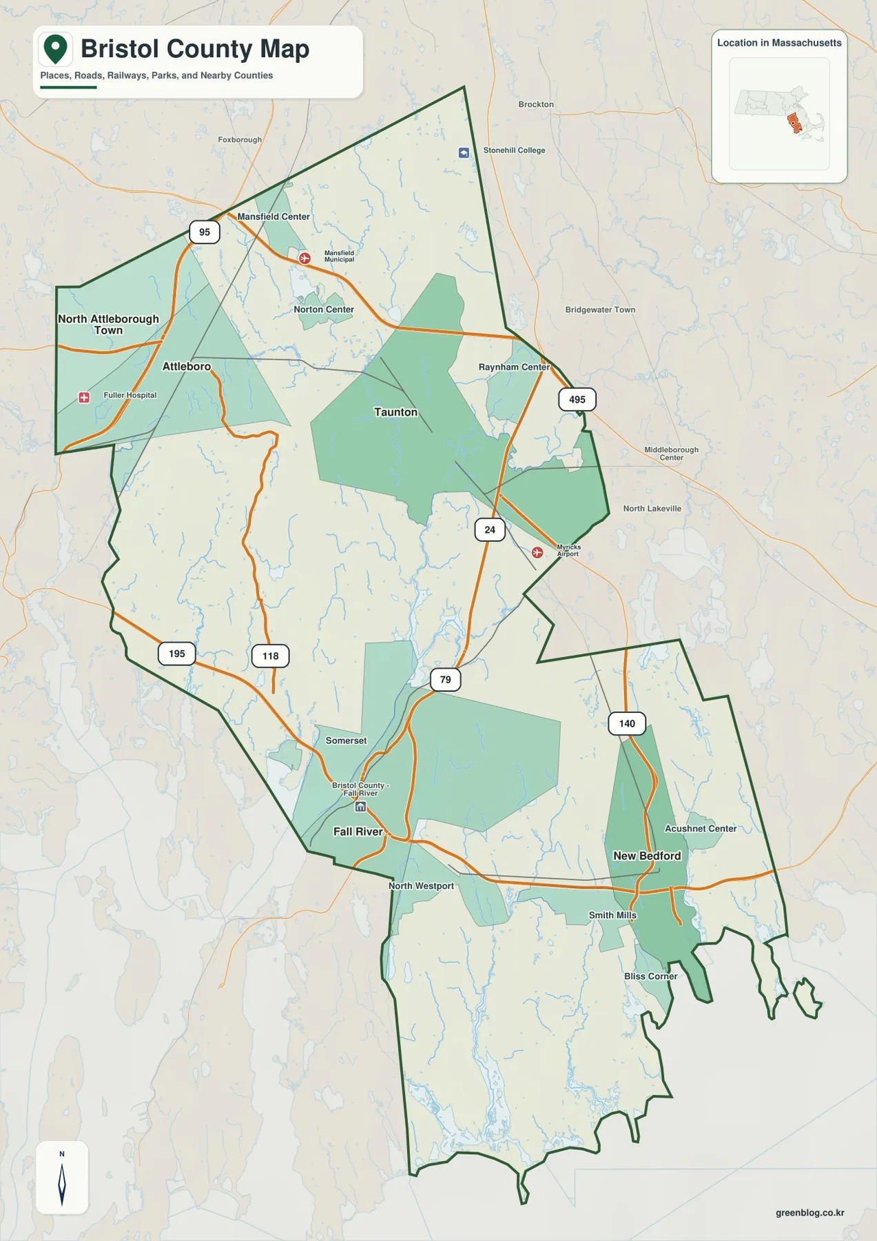
In the northwest, I-95 passes close to North Attleborough and Attleboro before continuing through the Mansfield area. This corner of the county is closely tied to the larger interstate network between Rhode Island and the Boston region. Farther east, I-495 runs along the northeastern side of the county and approaches the Route 24 corridor. Route 24 then provides a strong north-south reference on the eastern side of Taunton. These roads make the northern half of Bristol County look distinctly inland, even though the county eventually opens onto several coastal waters in the south.
The southern road pattern has a different character. Route 79 is a useful reference near Somerset and Fall River, while I-195 crosses the lower part of the county and links the Fall River side with the New Bedford area. Route 140 runs north from New Bedford into the interior and becomes one of the clearest ways to orient the southeastern section. The two large coastal cities are therefore connected by a major east-west interstate, but they are not one continuous urban strip on this map. Towns, river corridors, reservoirs, and less densely labeled areas occupy the space between and around them.
The county outline reinforces that sense of multiple subregions. The northwestern edge projects toward Rhode Island around Attleboro and North Attleborough, while the eastern boundary bends around the Raynham and southeastern interior. In the south, the Fall River side meets water along the western coastal edge, whereas New Bedford and Dartmouth face a different set of bays and estuaries to the east and southeast. A trip across Bristol County is therefore easier to understand by asking which urban corridor and highway it follows rather than treating the county as a simple north-south rectangle.
The general map is intended for regional orientation, not live navigation. Highway numbers and city positions are useful for planning a presentation, a classroom handout, or a broad county overview, but road work, closures, traffic, and local access conditions can change. For a concise explanation of the county, I-95 and I-495 define much of the north, Route 24 organizes the central-eastern interior, and I-195 with Route 140 provides a clear framework for the southern urban corridor.
How the five-city index divides the county into three urban zones
The city-distribution map intentionally removes most of the general map’s road and place detail. Its CITY INDEX ranks New Bedford first, Fall River second, Taunton third, Attleboro fourth, and North Attleborough Town fifth. Numerical values appear beside those names, but they are best treated as the figures used by this specific ranking layer rather than as a replacement for a current official population table. The main value of this map is visual: it shows where the selected urban centers sit inside the long, irregular county outline.
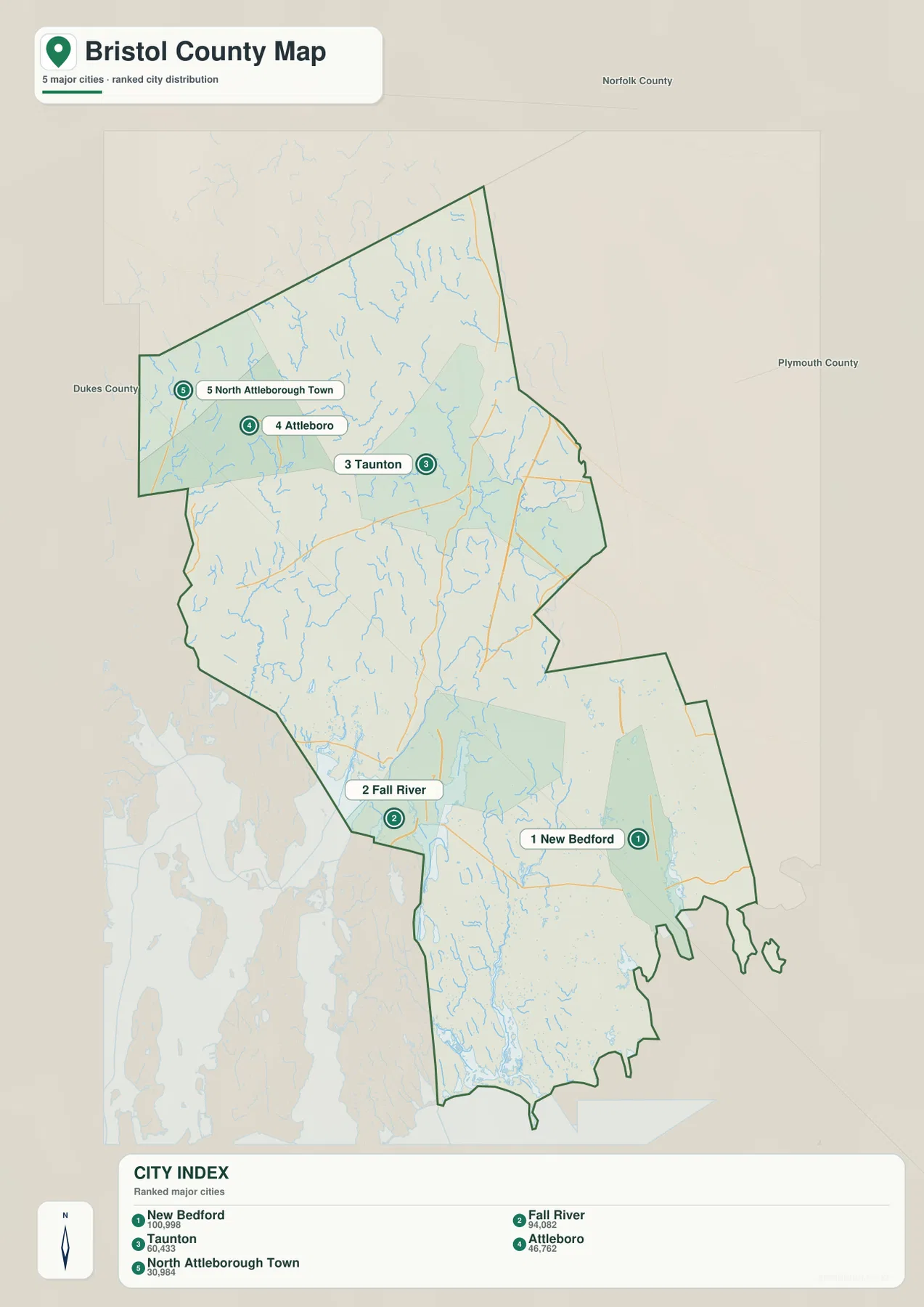
The five markers form three clear groups rather than a single chain. New Bedford and Fall River occupy separate positions near the southern coast. Taunton stands alone farther north in the central interior. Attleboro and North Attleborough form a northwestern pair close to the I-95 corridor. That pattern is useful when explaining the county to someone who does not yet know the local geography, because it establishes the major urban reference points before smaller towns and secondary roads are added.
This is not a complete municipal map. The Massachusetts Secretary of the Commonwealth lists 20 municipalities in Bristol County, including Acushnet, Berkley, Dartmouth, Dighton, Easton, Fairhaven, Freetown, Mansfield, Norton, Raynham, Rehoboth, Seekonk, Somerset, Swansea, and Westport in addition to the places highlighted by the city layer. The five-city graphic should therefore be read as a selective ranking view, not as an inventory of every city, town, village, or municipal boundary in the county.
For teaching or presentation use, the simplification can be an advantage. New Bedford and Fall River can be introduced as the two major southern reference points, Taunton as the interior anchor, and the Attleboro pair as the northwestern group. Returning to the general map then adds the road logic: I-195 helps connect the southern cities, Route 24 passes near the Taunton area, and I-95 defines the northwestern corridor. This two-step approach is easier to read than asking an audience to absorb every road and place label at once.
Taunton River tributaries, the New Bedford side, and the Buzzards Bay coast
The terrain-and-water layer gives the county a different structure from the road map. The Taunton River is the strongest named waterway through the central and southwestern portion of the map. Massachusetts’ Taunton River Basin overview describes the river as beginning at the confluence of the Town and Matfield rivers in Bridgewater and flowing generally southwest to Mount Hope Bay at the Fall River–Somerset municipal border. On this county map, that broad southwestward course helps connect inland Taunton with the water-facing communities near the lower river.
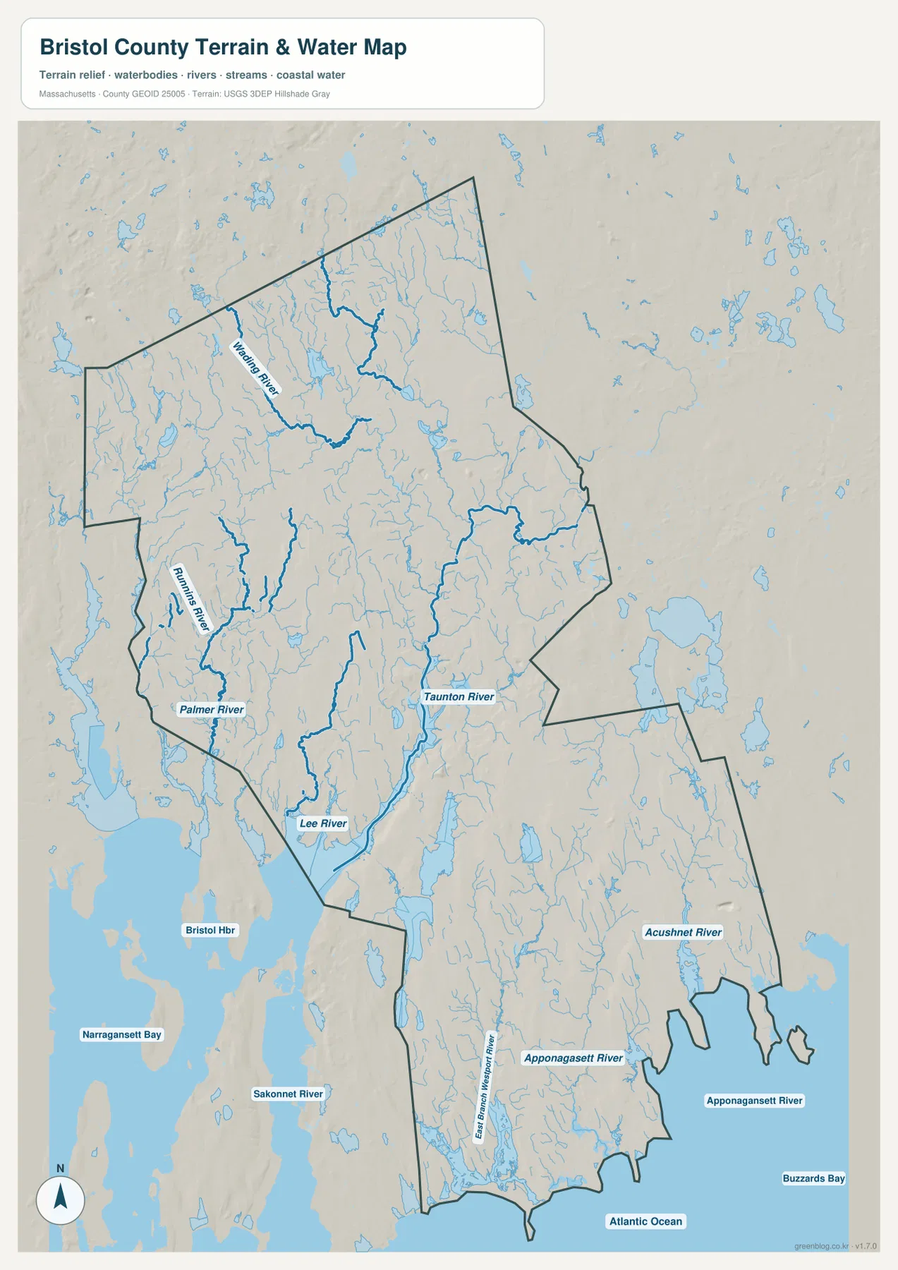
Several tributaries make the inland network more detailed. The Wading River is prominent in the north, while the Rumford River and Palmer River are labeled farther west. The Lee River appears near the southwestern side as the map approaches the Fall River and Somerset waterfront. Comparing these streams with the general map shows that the central and western parts of Bristol County are not simply crossed by roads; they are also divided and connected by a dense set of lowland river corridors that influence how towns and transportation routes fit together.
Southeastern Bristol County belongs to a visibly different coastal setting. The Acushnet River runs toward the New Bedford area, while the Apponagansett River and East Branch Westport River appear farther south around Dartmouth and Westport. Buzzards Bay occupies the large water body to the southeast, and the Atlantic Ocean is labeled along the southern edge. Narragansett Bay and the Sakonnet River appear to the west outside or along the broader regional context. These labels show that the Fall River side and the New Bedford–Dartmouth side face different estuarine and coastal systems even though both are part of the same county.
The Massachusetts Office of Coastal Zone Management administers the Buzzards Bay National Estuary Program, which focuses on protecting and restoring water quality and living resources in Buzzards Bay and its watershed. That official context is useful because it places the southeastern shoreline on the map within a larger estuary rather than treating it as an undifferentiated ocean edge. The map on this page, however, is not a flood map, wetland-regulation map, navigation chart, or water-depth product. It should be used to understand broad river and coastal relationships, not to make site-specific safety or regulatory decisions.
The shaded relief is intentionally generalized. Bristol County does not show the dramatic high ridges seen in western Massachusetts, but subtle inland relief and broad low coastal zones still provide useful context for the river network. Numerous small streams occupy the north and center, while wider tidal and coastal waters become more important toward the south. The relief shading is helpful for regional orientation, but it is not precise enough to determine the elevation of a property, road grade, flood threshold, or engineering site.
Reading Bristol County as a northwest interstate zone, a Taunton interior, and a southern coast
A three-part mental map makes Bristol County easier to navigate. In the northwest, start with North Attleborough, Attleboro, and Mansfield and then find I-95. This area is oriented toward the interstate network and neighboring inland communities more than toward the coast. I-495 appears farther east, while Route 24 leads toward the central part of the county. Looking only at the southern shoreline would miss this important northern transportation geography.
For the middle of the county, Taunton works as both an urban and hydrologic anchor. On the general map, it occupies a central position near major north-south routes. On the water map, the Taunton River provides a second reference running toward the southwest. The Wading, Rumford, and Palmer rivers add more detail around the surrounding interior. Moving between the two maps makes it easier to understand why Taunton is useful as a midpoint between the northern highway zone and the two major coastal cities.
In the south, it helps to treat Fall River and New Bedford as separate coastal anchors. Fall River is on the western side of the county near Somerset and the lower Taunton River system. New Bedford is farther east on the Buzzards Bay side and connects northward through Route 140. I-195 crosses the southern part of the county between these two urban areas, but Dartmouth, Westport, Acushnet, Fairhaven, and other municipalities create a much broader southern region than a simple city-to-city line would suggest.
Each of the three supplied maps serves a different part of this regional reading. The general map has the most useful combination of roads, places, and boundaries. The city layer is better when the goal is to compare the five selected urban points without visual clutter. The terrain-and-water layer is the clearest choice for explaining the Taunton River system, the southeastern rivers, and the relationship between Fall River, New Bedford, Buzzards Bay, and the surrounding coastal waters. Because all three retain the same county outline, locations can be transferred from one map to another without much difficulty.
Choosing the best Bristol County map file for print, classwork, or reference
The general county map is the most flexible file for a regional overview. It includes Taunton, Fall River, New Bedford, North Attleborough, Attleboro, Somerset, and other useful labels alongside the major highway framework. A presentation can explain the county effectively by highlighting I-95 and I-495 in the north, Route 24 near the center, and I-195 with Route 140 in the south. The map does not need to show every local street to communicate the county’s broad transportation pattern.
The city map works best when simplicity matters more than detail. Its five ranked points make it suitable for a slide, worksheet, or quick comparison of the county’s main urban reference locations. The water map is the stronger choice for environmental geography or physical context because the Taunton River and its tributaries can be compared with the New Bedford-side rivers and Buzzards Bay. Using the three maps together allows readers to move from city distribution to roads and then to river and coastal context without mixing every type of information into one crowded graphic.
The high-resolution JPG files are useful for screen viewing, printing, presentations, and non-survey regional comparison. They are not legal boundary documents, parcel maps, live traffic products, flood determinations, navigation charts, or engineering surveys. When a project depends on exact municipal boundaries, current road conditions, authoritative water information, or official demographic statistics, the Census Bureau, Massachusetts agencies, USGS, and the appropriate local authority should be consulted alongside these reference maps.
Frequently Asked Questions
Why are Taunton, Fall River, and New Bedford all shown as county seats?
The Massachusetts Secretary of the Commonwealth’s county list marks all three as county seats. Their positions are geographically separated: Taunton is inland, Fall River is on the southwestern side, and New Bedford is on the southeastern coast. Specific county or court functions may be handled at different locations, so anyone visiting an office should still check the responsible agency’s current information.
Which map is best for following the Taunton River and nearby tributaries?
The terrain-and-water map is the best choice. It shows the Taunton River together with the Wading, Rumford, Palmer, and Lee rivers and also provides the southeastern Acushnet and Apponagansett systems for comparison. It is a regional reference layer, not a flood, water-depth, navigation, or water-quality map.
Why does the city map highlight only five places?
The city layer is a selective ranking graphic rather than a complete municipal map. Massachusetts’ official county list contains 20 Bristol County municipalities, so many towns are intentionally omitted from the five-marker view. Use the general county map when you need a broader set of place names and road references.
Map File Information
The ZIP contains the original high-resolution JPG versions of the general county map, major-city distribution map, and terrain-and-water reference map discussed on this page.
- Included Files: general county map, major-city distribution map, terrain-and-water reference map
- File Type: JPG
Related Maps
Sources and references
These official sources provide useful background for Bristol County municipalities and county seats, the Taunton River, Buzzards Bay, boundary data, and hydrography.
- Massachusetts Secretary of the Commonwealth – List of Counties
- Mass.gov – Taunton River Basin Overview
- Mass.gov – Buzzards Bay National Estuary Program
- U.S. Census Bureau QuickFacts – Bristol County, Massachusetts
- U.S. Census Bureau TIGER/Line Shapefiles
- USGS National Hydrography
Green Map creates custom-edited map images using open geographic data sources such as geoBoundaries, Natural Earth, OpenStreetMap, and government open data. These maps are edited visual materials, not raw data files, and are provided for education, documents, presentations, and graphic reference.