Queen Anne’s County spans a distinctive part of Maryland’s Eastern Shore, from Kent Island and the Chesapeake Bay Bridge corridor to Centreville, Church Hill, Sudlersville, and the agricultural northeast. Stevensville, Chester, and Grasonville form the strongest western settlement cluster, while Centreville and Queenstown organize the mainland center and smaller towns spread across the northern interior. This page explains the roads, settlement distribution, rivers and creeks, and low-relief elevation pattern shown on the supplied maps. Matching high-resolution JPG files are also available together in a downloadable ZIP archive.
Queen Anne’s County officially recognizes eight incorporated municipalities: Barclay, Centreville, Church Hill, Millington, Queen Anne, Queenstown, Sudlersville, and Templeville. County planning material identifies Centreville as the county seat, while the official tourism site places the county at the eastern end of the Chesapeake Bay Bridge and describes U.S. 50/301 as a major transportation route into the Delmarva Peninsula. Those facts match the map’s strong contrast between the busy Kent Island corridor and the broad rural interior.
Table of Contents
Kent Island and U.S. 50/301 form the county’s most concentrated western corridor
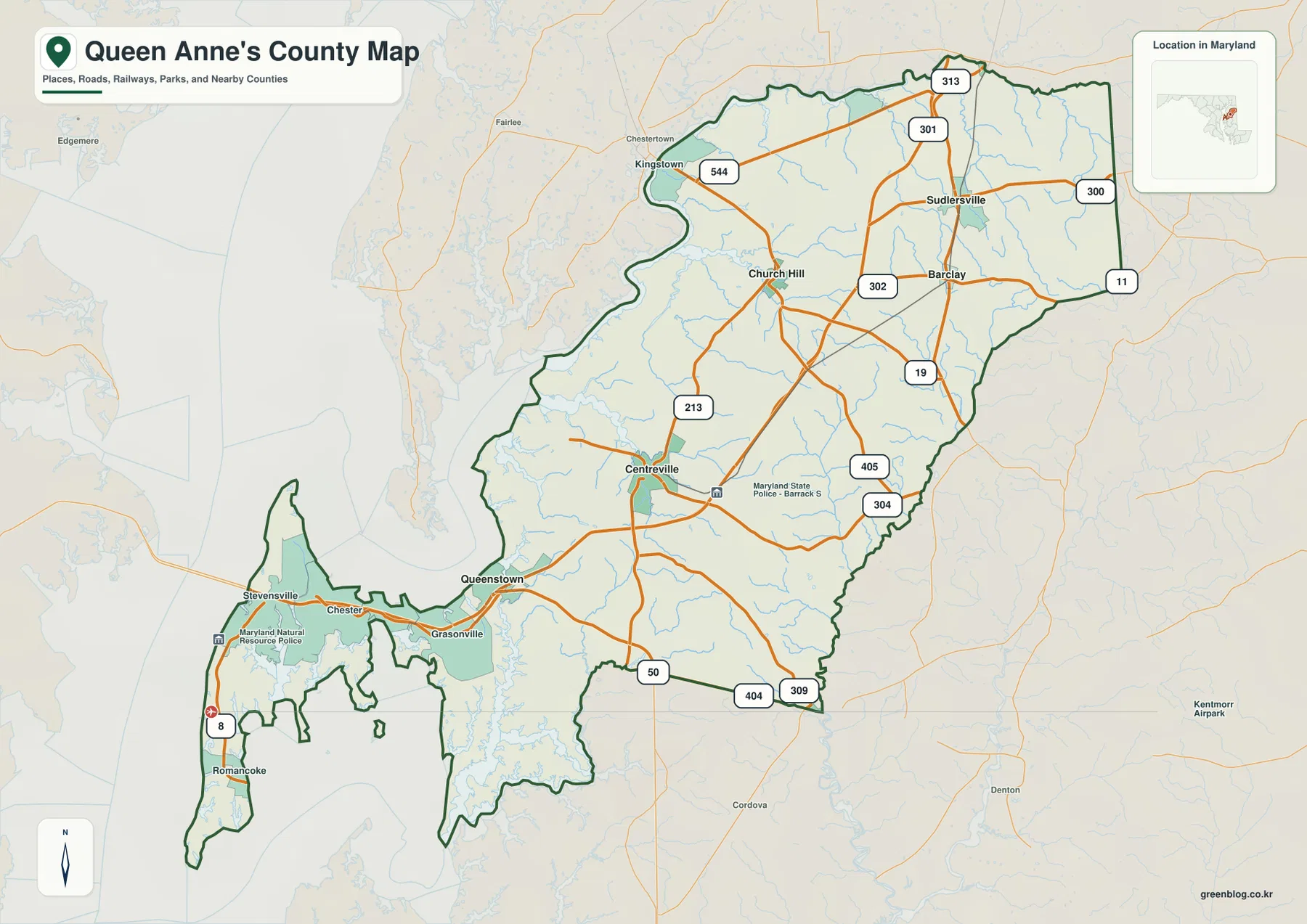
Stevensville, Chester, and Grasonville sit close together on the western side. Stevensville lies near the eastern end of the Chesapeake Bay Bridge, MD 8 runs south through the island, and U.S. 50/301 carries traffic through Chester and Grasonville toward the mainland. The density of roads and settlement labels here is noticeably greater than across most of the northern county.
Queenstown appears east of Grasonville along the U.S. 50/301 corridor. County town information notes that Queenstown was the first county seat after Queen Anne’s County was established, with the seat moving to Centreville in 1782. That history gives the town added significance beyond its modern position on a major highway corridor.
The southern and western edges of Kent Island are cut by Chesapeake Bay, Eastern Bay, and numerous smaller tidal creeks. MD 8 continues south toward Romancoke as settlement labels thin out and shoreline becomes more dominant. The map therefore shows the island as a complex coastal landscape rather than a simple block of land.
U.S. 50/301 is the main link between this western settlement cluster and Queenstown-Centreville mainland areas. The static map does not show live Bay Bridge traffic, incidents, or seasonal congestion, so actual trips should be checked with Maryland Transportation Authority information and a current navigation service.
Centreville, Church Hill, and Sudlersville reveal the agricultural mainland pattern
Centreville is the strongest mainland reference near the middle of the county, with MD 213 providing a clear north-south route. Roads branch west toward Queenstown and east toward the MD 304-405 side. Queen Anne’s County town information identifies Centreville as both the county seat and the largest incorporated municipality, located at the head of navigation on the Corsica River.
Church Hill lies north of Centreville, with MD 213, MD 19, and MD 302 providing useful road references. Sudlersville and Barclay occupy the northeastern agricultural interior, where U.S. 301 and MD 313 become stronger orientation points. The county describes Barclay as a small agricultural crossroads at the intersection of MD 313 and MD 302, which matches its position on the map.
MD 300 and MD 11 appear east of Sudlersville, and roads continue toward the Kent and Delaware-side landscape beyond the county. Compared with Kent Island and the U.S. 50 corridor, this northern section contains much wider spaces between town labels and many small streams crossing farmland.
MD 404, MD 309, and MD 304 help locate the southeastern mainland near Caroline County. The Town of Queen Anne sits near the southeastern boundary, while Templeville straddles the Queen Anne’s-Caroline county line. Not every incorporated place receives the same visual emphasis on the general map, so the official municipal list and the map should be read together.
The City Index spreads six ranked towns across the center, north, west, and southeast
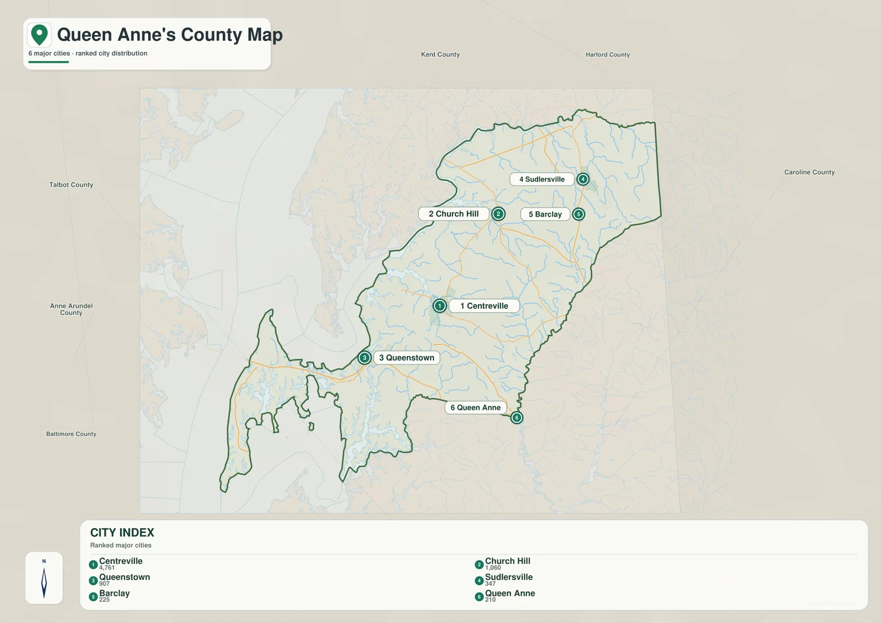
The City Index ranks Centreville, Church Hill, Queenstown, Sudlersville, Barclay, and Queen Anne. It prints the values 4,761 for Centreville, 1,060 for Church Hill, 907 for Queenstown, 347 for Sudlersville, 225 for Barclay, and 210 for Queen Anne. The graphic does not state a reference year or statistical definition, so these figures should not be presented as current population counts. Current values should come from the latest U.S. Census Bureau or town data.
Centreville sits near the center-south of the mainland, Queenstown lies to the west, and Church Hill occupies the north-central section. Sudlersville and Barclay cluster farther northeast, while Queen Anne is separated toward the southeastern boundary. The pattern shows small towns dispersed through a largely rural county rather than forming one continuous urban belt.
The six-place ranking is not a complete municipal list. Queen Anne’s County officially has eight incorporated municipalities, with Millington and Templeville absent from this City Index. Important unincorporated or census-designated communities such as Stevensville, Chester, and Grasonville also belong to the county’s settlement geography even though they are not part of the incorporated-town list.
No connector lines or mileage values are printed between the ranked places. The graphic should not be used to estimate driving distance from Centreville to Queenstown or Sudlersville. It works best as a quick town-distribution view, with the full road map and current navigation information used for actual routes.
Chesapeake Bay, Eastern Bay, Corsica River, and Wye River reshape the western and southern county
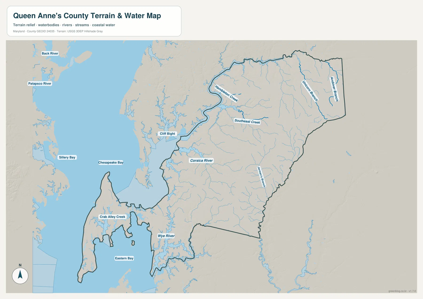
Chesapeake Bay is the dominant western water body, while Eastern Bay surrounds much of the county’s southwestern edge. Crab Alley Creek cuts into the Kent Island side, and Wye River forms a major water feature along the southern mainland. These waterways make the western and southern county boundaries far more irregular than the comparatively straight northeastern interior.
Corsica River is the strongest named waterway near Centreville. County town information places Centreville at the head of navigation on this Chester River tributary. Farther north, Hambleton Creek and Southeast Creek create lower corridors toward the Chester River side, while Unicorn Branch and Andover Branch run through the northeastern interior.
German’s Branch appears farther south and east, accompanied by a dense network of smaller tributaries. These streams are modest compared with Chesapeake Bay or Eastern Bay, but they divide the agricultural mainland into many shallow valleys. Their positions align closely with the green low corridors on the elevation map.
The county’s official tourism site describes more than 200 miles of waterfront, reflecting how deeply bays, rivers, and creeks shape local geography. The terrain-water graphic here is a broad reference rather than a flood map, depth chart, navigation product, or legal water-boundary source, so boating and hazard decisions require current NOAA, FEMA, USGS, Maryland, or local information.
A 14-meter mean elevation still leaves a clear inland-to-coast contrast
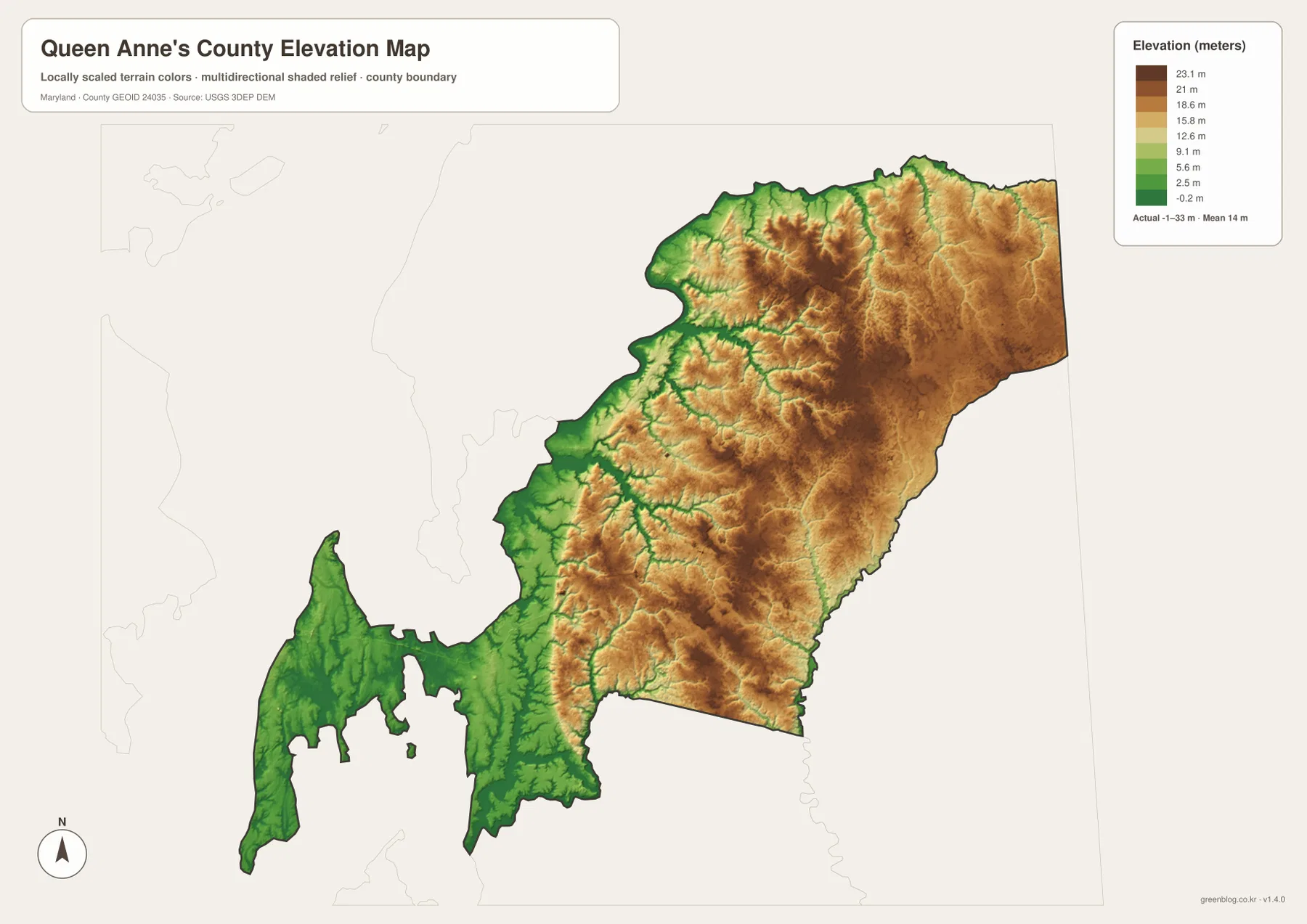
The elevation graphic reports an actual data range from -1 to 33 meters and a mean elevation of 14 meters. Queen Anne’s County is a low-relief Eastern Shore county, but the surface is not uniformly flat. Higher tan and brown terrain covers much of the northeast and east-central interior, while Kent Island and the Chesapeake-Eastern Bay side are dominated by lower green terrain.
North of Centreville toward Church Hill and Sudlersville, small ridges are repeatedly cut by stream valleys. Southeast Creek, Unicorn Branch, and Andover Branch occupy lower green corridors that match their positions on the water map. Even where absolute elevation is modest, small differences can influence drainage, wetlands, and the shape of local roads.
Kent Island and the mainland west of Centreville become progressively lower toward Chesapeake Bay and Eastern Bay. Low terrain also follows Wye River, Crab Alley Creek, and Corsica River. The overall pattern is a gentle rise from the coast toward the interior, interrupted by numerous creek valleys.
The -1 to 33 meter range is the overall data range printed on the supplied elevation graphic, not a property survey. Engineering, drainage design, surveying, and flood-risk work require authoritative USGS elevation information, professional measurements, and current FEMA or local flood products. Low elevation by itself does not establish a specific flood probability.
Use the Kent Island corridor for travel context and the inland maps for the county’s rural geography
The general county map is the best starting point for Stevensville, Chester, Grasonville, Queenstown, Centreville, U.S. 50/301, MD 8, and MD 213. The City Index is cleaner when the goal is to compare six ranked incorporated towns. For natural geography, the water map highlights Chesapeake Bay, Eastern Bay, Corsica River, Wye River, and the smaller creeks, while the elevation view explains the subtle rise from coastal lowlands toward the northeastern interior.
Queen Anne’s County’s 2022 Comprehensive Plan emphasizes maintaining the county’s rural character. That policy direction is visible geographically: the concentrated Kent Island-U.S. 50 corridor quickly gives way to wide agricultural areas around Centreville, Church Hill, Sudlersville, and Barclay. The maps make the county’s combination of transportation access, small towns, farmland, and extensive waterfront especially clear.
The downloadable originals are JPG files measuring 3638 × 2572 pixels each. They work well in landscape documents and can be enlarged around Kent Island, Centreville, Church Hill, Corsica River, or other areas for classroom material, presentations, and personal reference. Enlargement does not add live traffic, parcel boundaries, flood zones, water depth, or survey-grade elevation, so specialized decisions should always use current official data.
Frequently Asked Questions
What is the county seat of Queen Anne’s County, Maryland?
Centreville is the county seat. Queen Anne’s County town information also describes Centreville as the county’s largest incorporated municipality and places it at the head of navigation on the Corsica River.
Does the six-place City Index include every incorporated municipality in Queen Anne’s County?
No. The index shows Centreville, Church Hill, Queenstown, Sudlersville, Barclay, and Queen Anne, while the county officially lists eight incorporated municipalities. Millington and Templeville are not among the six ranked places.
Does the -1 to 33 meter elevation range mean every low coastal area has the same flood risk?
No. The range describes the overall elevation data used for the map. Actual flood risk also depends on tides, rainfall, drainage, local topography, and flood-protection conditions, so current FEMA and local flood information should be used for decisions.
Map File Information
The ZIP archive contains high-resolution JPG maps of Queen Anne's County matching the map themes described on this page.
- Included Files: county and major roads map, City Index map, terrain and water map, elevation map
- Printable Size: 3638 × 2572 pixels each
- File Type: JPG
Related Maps
Sources and References
- Queen Anne’s County – Incorporated Town Plans
- Queen Anne’s County – 2022 Comprehensive Plan
- Visit Queen Anne’s County – Getting Here
- U.S. Census Bureau – TIGER/Line Shapefiles
- USGS – National Hydrography
- USGS – 3D Elevation Program
Green Map creates custom-edited map images using open geographic data sources such as geoBoundaries, Natural Earth, OpenStreetMap, and government open data. These maps are edited visual materials, not raw data files, and are provided for education, documents, presentations, and graphic reference.