Garrett County occupies Maryland’s far western mountain country, where Oakland and Mountain Lake Park sit south of Deep Creek Lake, Grantsville, Accident, and Friendsville spread across the north, and steep river valleys cut through the eastern and southern edges. Pennsylvania borders the county to the north, West Virginia wraps around much of the west and south, and Allegany County lies to the east. This page explains the settlement pattern, major roads, lakes and rivers, and unusually high relief shown on the supplied maps. Matching high-resolution JPG files are also available together in a downloadable ZIP archive.
Garrett County’s comprehensive plan identifies Oakland as the county seat and lists eight incorporated towns: Accident, Deer Park, Friendsville, Grantsville, Kitzmiller, Loch Lynn Heights, Mountain Lake Park, and Oakland. County recreation planning material places the entire county in the Appalachian highlands and identifies Hoye-Crest at about 3,360 feet as Maryland’s highest point. Those official facts fit the maps closely: broad uplands dominate much of the county, while the Youghiogheny, Savage, and Potomac systems cut deep valleys through the high terrain.
Table of Contents
Oakland and Deep Creek Lake anchor the southwestern settlement area
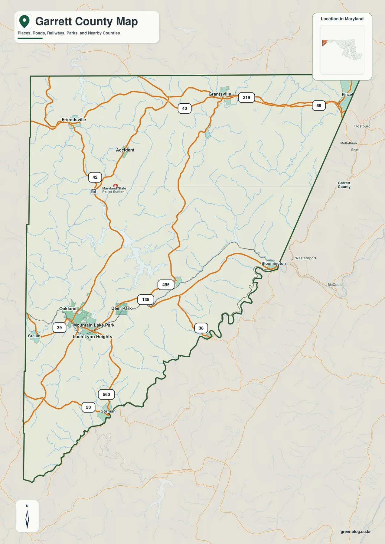
Oakland is the clearest place to begin on the general map. Mountain Lake Park and Loch Lynn Heights sit immediately nearby, while Deer Park is farther east. MD 39 heads west from the Oakland area toward West Virginia, and MD 135 links Deer Park with the eastern side and the Bloomington direction. The concentration of settlements in the southwest makes this area a useful anchor before moving into the more dispersed northern and eastern parts of the county.
Deep Creek Lake lies directly north of the Oakland-Mountain Lake Park area and is one of the most prominent shapes on the road map. MD 495 runs through the lake-side interior, while U.S. 219 continues north toward Grantsville. Roads around the lake curve with the shoreline and rolling terrain, so the pattern is less regular than it would be across a flat plain.
Gorman appears near the southern West Virginia line, with MD 560 and U.S. 50 providing local road references. Settlement labels become less frequent toward the county’s southern tip, while long ridges and drainage valleys become more visually important. The road pattern reflects this terrain by following lower corridors through the mountains rather than crossing the uplands in a simple grid.
Garrett County’s elevation and winter climate make live road conditions especially important. The general map does not show snow, ice, closures, construction, or current travel time. Use it for geographic orientation, then check current Maryland transportation information and a navigation service before actual travel.
I-68, U.S. 40, and U.S. 219 organize the Grantsville-Accident-Friendsville north
I-68 and U.S. 40 provide the strongest east-west references across northern Garrett County. Grantsville sits close to U.S. 40 and U.S. 219, while I-68 continues toward Finzel and the Allegany County side. Friendsville lies farther northwest near the Youghiogheny valley, and Accident sits southwest of Grantsville in the interior. The three towns are separated by uplands and streams rather than forming one continuous built-up area.
U.S. 219 is the key north-south corridor connecting Grantsville with the Deep Creek Lake and Oakland side. MD 42 appears near Accident, while the Friendsville roads respond more directly to the Youghiogheny River valley. A simple way to read the north is to use I-68 and U.S. 40 for east-west position and U.S. 219 for the main north-south connection.
The central-northern map is crossed by many small blue stream lines. On the terrain-water view, those waterways become part of the Bear Creek and Youghiogheny drainage. The road map can make the upland look broad and open, but the stream network reveals that it is dissected by many smaller valleys.
East of Finzel, the transportation corridor continues toward Frostburg and Allegany County. I-68 is therefore important not only inside Garrett County but across western Maryland. The mountain setting means weather can affect the corridor quickly, so live travel decisions should rely on current road information rather than this static county map.
The City Index divides the six ranked towns between the southwest and the northern uplands
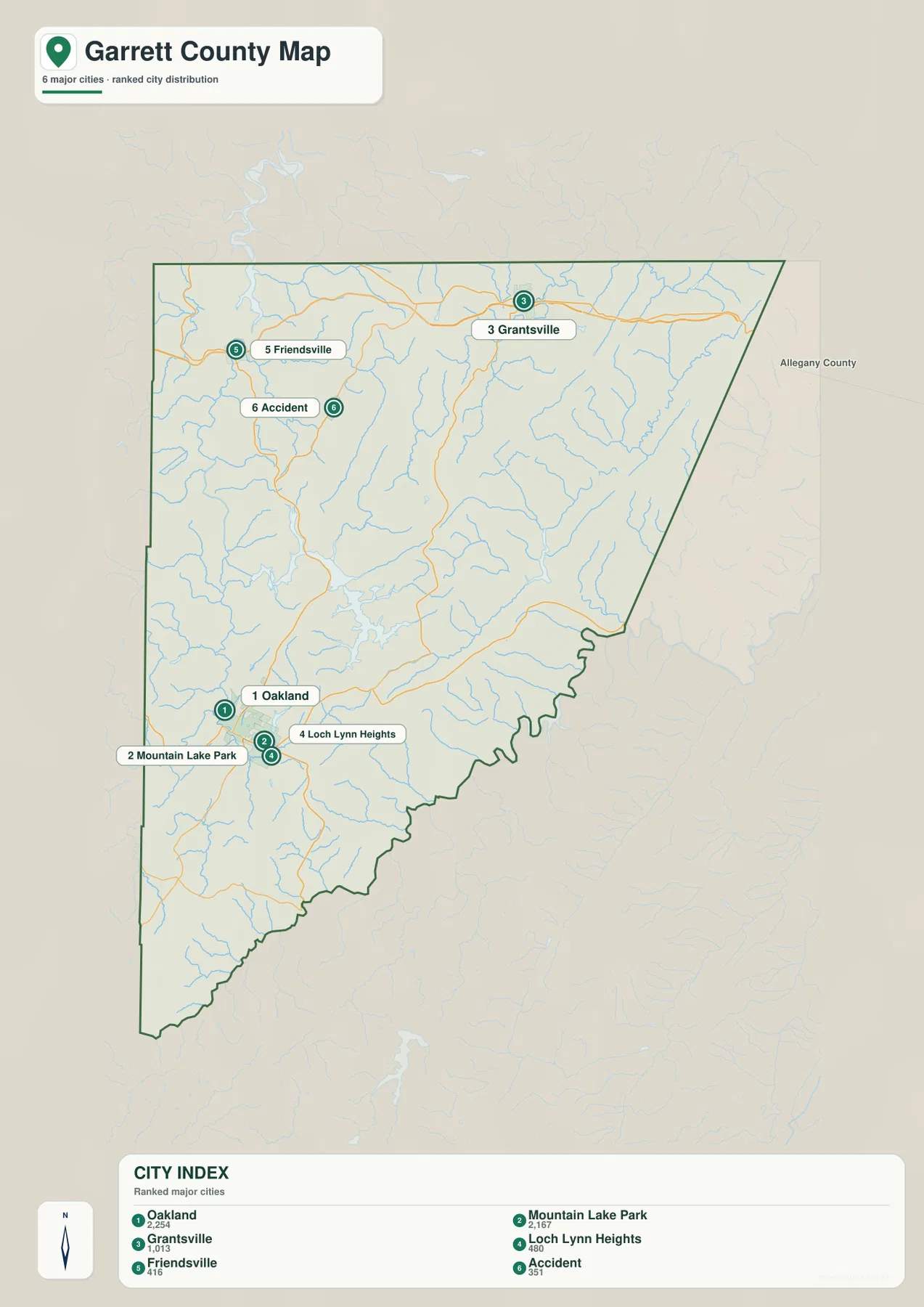
The City Index ranks Oakland, Mountain Lake Park, Grantsville, Loch Lynn Heights, Friendsville, and Accident. It prints the values 2,254 for Oakland, 2,167 for Mountain Lake Park, 1,013 for Grantsville, 480 for Loch Lynn Heights, 416 for Friendsville, and 351 for Accident. The graphic does not state a reference year or statistical definition, so these values should not be presented as current population counts. Current figures should come from the latest U.S. Census Bureau or Garrett County data.
The spatial arrangement is more useful than the ranking itself. Oakland, Mountain Lake Park, and Loch Lynn Heights form a close southwestern cluster, while Grantsville, Friendsville, and Accident are spread across the north. This two-part distribution reflects the way Garrett County’s towns occupy separate mountain corridors rather than one large urban center.
Garrett County’s official municipality list also includes Deer Park and Kitzmiller, neither of which appears among the six ranked places. The City Index is therefore a simplified selection rather than a complete municipal directory. Use the general county map when those other incorporated towns or smaller communities matter.
No connector lines or mileage values appear between the six markers. The graphic should not be used to estimate driving distance from Oakland to Grantsville, Accident, or Friendsville. It works well for quick settlement distribution, while the full road map and current routing information are better for travel.
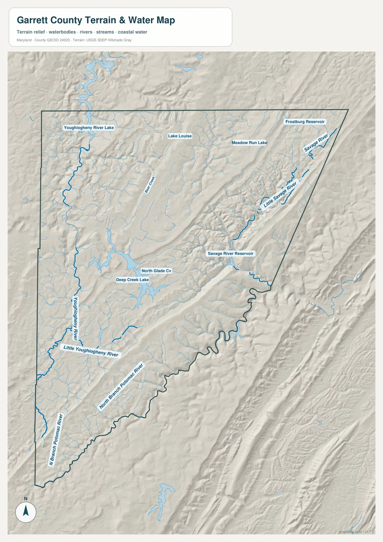
Deep Creek Lake and the Youghiogheny system dominate the central and western water map
Deep Creek Lake is the largest and most recognizable water body in the county interior, with North Glade Cove labeled along its shoreline. Garrett County maintains a dedicated Deep Creek Lake page with lake-level, watershed-management, and water-quality information. On the map, the lake provides a strong reference between the Oakland area and the higher uplands to the north and east.
Youghiogheny River runs through the western side, with Youghiogheny River Lake in the north and Little Youghiogheny River joining from the southwest. The Friendsville area is closely tied to this river valley. Shaded relief makes the river’s position particularly clear because the channel sits well below the surrounding uplands.
The eastern side is organized by Savage River and Little Savage River, with Savage River Reservoir forming a major water landmark. Meadow Run Lake and Frostburg Reservoir are labeled farther north. This side of the county contains some of the most strongly dissected terrain, and the reservoirs occupy narrow lower corridors between high ridges.
North Branch Potomac River appears along much of the southern and southeastern boundary. Together with the Youghiogheny and Savage systems, it shows that Garrett County’s high terrain drains into several major river corridors. The map is not a flood map, depth chart, water-quality report, or boating-safety product; those uses require current USGS, Maryland DNR, FEMA, or local information.
A 291–1,023 meter data range highlights Maryland’s highest mountain county
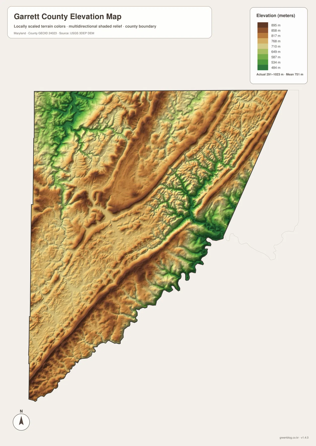
The elevation graphic reports an actual data range from 291 to 1,023 meters and a mean elevation of 751 meters. Garrett County is exceptionally high by Maryland standards. County planning material identifies Hoye-Crest at roughly 3,360 feet as the highest point in the state, which closely matches the upper end of the supplied elevation dataset.
Long ridges cross the north and center, while Bear Creek, Youghiogheny, and Savage drainage corridors form lower green valleys between them. The highland is not a single flat plateau: repeated ridges and incised valleys create strong local relief. Comparing the water map with the elevation colors makes the relationship between streams and lower terrain immediately clear.
The Savage River side in the east contains especially deep stream valleys, and low green terrain also follows North Branch Potomac River along the south. The Youghiogheny valley drops below the surrounding western uplands as well. Broad ridge tops and high plateaus remain in tan and brown between those river systems, giving the county its distinctive mountain character.
The 291–1,023 meter range is the overall data range printed on the supplied elevation image, not a property survey. Exact road, building, or parcel elevations require authoritative USGS elevation data or professional surveying. Flood and hazard decisions should likewise rely on current FEMA, Maryland, and local products rather than map color alone.
Use the road map for towns and highways, then switch to water and elevation for the mountain landscape
The general county map is the best starting point for Oakland, Mountain Lake Park, Grantsville, Friendsville, I-68, U.S. 40, U.S. 219, and MD 135. The City Index is cleaner when the goal is simply to compare six ranked towns. For natural geography, the water map shows Deep Creek Lake, Youghiogheny River, Savage River Reservoir, and North Branch Potomac River, while the elevation map explains the unusually high ridges and deep valleys between them.
Deep Creek Lake is a particularly useful local reference. Garrett County provides dedicated watershed-management, lake-level, and water-quality information, and its management plan describes the lake as a major recreation and tourism center in western Maryland. The county map here helps place the lake within Garrett County, but current lake conditions, water use, and regulations should be checked with the responsible official agencies.
The downloadable originals are JPG files measuring 2572 × 3638 pixels each. They work well in full-page documents and can be enlarged around Oakland, Deep Creek Lake, Grantsville, Savage River, or other areas for classroom material, presentations, and personal reference. Enlargement does not add live road conditions, parcel boundaries, flood zones, water depth, or survey-grade elevation, so specialized decisions should always use current official data.
Frequently Asked Questions
What is the county seat of Garrett County, Maryland?
Oakland is the county seat. Garrett County’s comprehensive plan identifies Oakland as the county seat, and the general map shows it in the southwestern settlement cluster beside Mountain Lake Park and Loch Lynn Heights.
Does the six-place City Index include every incorporated town in Garrett County?
No. The index marks Oakland, Mountain Lake Park, Grantsville, Loch Lynn Heights, Friendsville, and Accident, while the county’s official list also includes Deer Park and Kitzmiller. The City Index is therefore a simplified ranked-place view rather than a complete municipal directory.
Can the 291–1,023 meter elevation range be used as a property survey?
No. It is the overall data range printed on the supplied elevation graphic and is useful for broad geographic comparison only. Exact property elevation should come from authoritative USGS or professional survey data, and flood or hazard decisions should rely on current official information.
Map File Information
The ZIP archive contains high-resolution JPG maps of Garrett County matching the map themes described on this page.
- Included Files: county and major roads map, City Index map, terrain and water map, elevation map
- Printable Size: 2572 × 3638 pixels each
- File Type: JPG
Related Maps
Sources and References
- Garrett County Government – Municipalities
- Garrett County Government – Deep Creek Lake
- Garrett County – Land Preservation, Parks and Recreation Plan
- U.S. Census Bureau – TIGER/Line Shapefiles
- USGS – National Hydrography
- USGS – 3D Elevation Program
Green Map creates custom-edited map images using open geographic data sources such as geoBoundaries, Natural Earth, OpenStreetMap, and government open data. These maps are edited visual materials, not raw data files, and are provided for education, documents, presentations, and graphic reference.