Kennebec County sits in central Maine, where the Kennebec River provides a natural way to organize the map. Waterville is in the northern part of the main river corridor, Augusta lies farther south, and Hallowell and Gardiner continue the chain toward the county’s southern edge. Away from that corridor, the map opens into broad lake country around Great Pond, Messalonskee Lake, Cobbosseecontee Lake, and China Lake. The three maps on this page can also be downloaded as high-resolution JPG files in one ZIP package. High-resolution map files are available for download in the section below.
Augusta is especially useful as a reference point because it is both the Kennebec County seat and Maine’s state capital. The county government lists its offices in Augusta, while the Maine Legislature records Augusta’s selection as the permanent capital in 1827. On the map, that administrative importance overlaps with geography: major roads converge near the city, the Kennebec River passes directly through the area, and several of the county’s better-known communities are arranged north or south of it.
Table of Contents
A river corridor linking four of the county’s cities
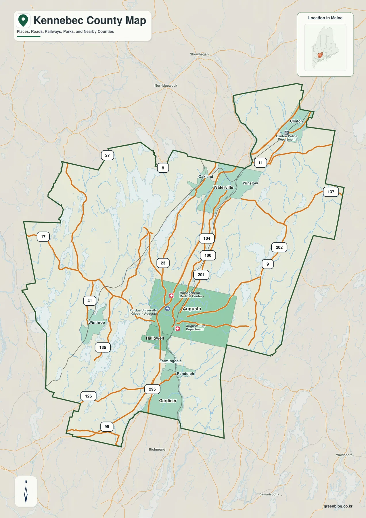
The clearest pattern on the county map is the north-south sequence along the Kennebec River. Waterville and Winslow appear near the northern end of the denser road network, Augusta occupies the central-southern section, Hallowell follows immediately below it, and Gardiner sits still farther south. The county does not have one continuous urban area, but these places are close enough to form a recognizable corridor when the river, highways, and city labels are viewed together.
Waterville is paired visually with nearby Oakland and Winslow, and several routes converge around the river crossing. U.S. 201, Route 100, and Route 104 help define the north-south movement in this part of the map. Waterville’s own comprehensive planning material describes the long importance of both the Kennebec River and Messalonskee Stream to settlement and industry, which gives useful historical context to the strong water-and-road relationship visible here.
Augusta forms the most prominent central node. I-95 passes through the area, U.S. 201 follows the river corridor, and U.S. 202 crosses the region on a more east-west course. Routes 17 and 27 extend toward the western side of the county, while Route 9 and other roads connect Augusta with communities to the east. This makes the city a practical orientation point even for someone who is interested mainly in the lakes or rural towns beyond the immediate river valley.
Hallowell and Gardiner show how closely the southern cities are tied to the river. Hallowell is just below Augusta, while Gardiner is farther downstream near the area where I-295 reaches its northern end. Randolph appears across the river from the southern corridor, reminding the reader that development is not confined to one bank. When these places are traced in order, the map becomes easier to read than if every local road and town is treated as a separate feature.
The contrast is stronger once the eye moves west or east. Winthrop sits among lakes and smaller roads in the southwest, and the northwestern side opens toward Great Pond and Messalonskee Lake. To the east, China Lake and a different set of streams occupy a landscape with fewer large city labels. Kennebec County therefore combines a relatively concentrated river corridor with broad lake and rural areas that are more dispersed.
How I-95, I-295, and U.S. 201 organize the road map
I-95 is the most obvious long-distance highway on the map, running through the Waterville-Augusta corridor and continuing beyond the county in both directions. Near the southern part of Kennebec County, I-295 provides another major connection toward the Portland region. U.S. 201 stays closer to the river through much of the central section. Together, these routes make it easy to identify the county’s principal north-south travel zone before looking at smaller roads.
East-west travel is more varied. U.S. 202 crosses Augusta and continues toward the eastern part of the county, while Routes 17 and 27 lead toward western communities and lake country. Routes 8, 11, 23, 41, 100, 104, 126, 135, and 137 are also labeled in different parts of the map. The point is not to memorize every number; a useful reading method is to find the interstate and U.S. routes first, then follow the state roads toward the town, lake, or boundary that matters for a particular task.
The western road pattern illustrates why this approach helps. Around Winthrop and the lake districts, roads bend and separate around water bodies instead of following the tight, mostly north-south arrangement found between Waterville and Augusta. The county map is therefore useful for comparing road density as well as road direction. It gives a quick sense of where a direct-looking line on a small-scale map may actually require a more indirect local route.
City Connections: Augusta as the hub, not a driving-distance chart
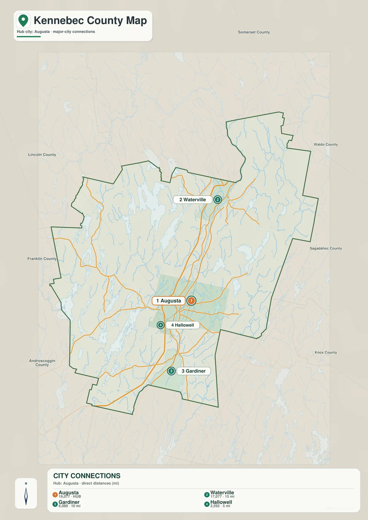
The City Connections map strips away much of the detail and uses Augusta as the hub for three other cities. Waterville is shown about 15 miles away, Gardiner about 10 miles away, and Hallowell about 5 miles away. The legend explicitly identifies these as direct distances. They should therefore be read as straight-line comparisons rather than road mileage, travel time, or route recommendations.
This simplified layout is particularly helpful for understanding direction. Waterville lies north of Augusta, while Hallowell and Gardiner are to the south. The county boundary is kept visible, and neighboring counties such as Somerset, Waldo, Sagadahoc, Knox, Lincoln, Androscoggin, and Franklin are labeled around the outside. That makes the graphic useful for a presentation or classroom setting where a full road map would contain more detail than the audience needs.
The small numeric values printed with the city labels should not be treated here as current population figures. The supplied image does not provide enough information to establish the statistical year or definition behind those values, so this article does not convert them into demographic claims. Anyone needing current population data should consult the U.S. Census Bureau or another current official source. The reliable purpose of this graphic is geographic: it shows the relative placement of the four cities and the direct-distance relationship to Augusta.
Great Pond, China Lake, and the waters beyond the main river
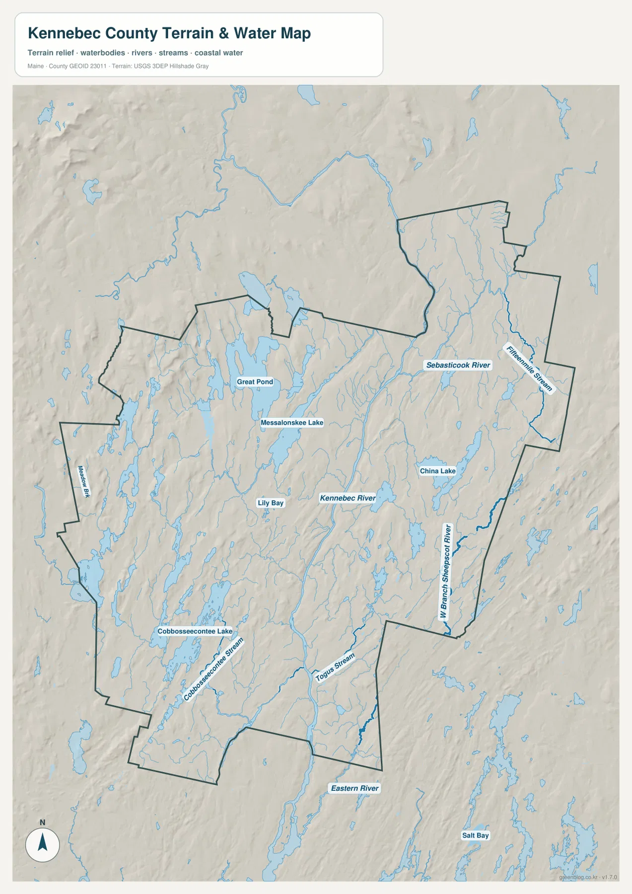
The terrain-and-water map changes the emphasis from roads to the county’s extensive network of lakes, rivers, and streams. The Kennebec River remains the central landmark, but the western half of the county becomes much more detailed. Great Pond is prominent in the northwest, Messalonskee Lake lies closer to the Waterville-Oakland side, and Cobbosseecontee Lake stretches through the southwest. These waters show why the western county cannot be understood simply as the area “away from Augusta.”
China Lake provides a similarly useful landmark east of the Kennebec River. Farther north and northeast, the Sebasticook River and Fifteenmile Stream are labeled, giving the eastern drainage network a different shape from the lake-dominated west. The West Branch Sheepscot River appears near the southeastern side, while Togus Stream is visible south and east of Augusta. By following these names, a reader can see that several watersheds intersect the county rather than everything draining directly into the Kennebec within the map area.
Cobbosseecontee Stream connects the southwestern water landscape with the lower Kennebec corridor, and the surrounding lakes help explain the curving road pattern seen on the general map. Great Pond and Messalonskee Lake create another cluster farther north. When the two map types are compared, roads that seemed irregular on the county map make more geographic sense because many must pass between or around large water bodies.
The Kennebec River itself remains the best single reference feature. It passes through the part of the county containing Waterville, Augusta, Hallowell, and Gardiner, and both settlement and transportation repeatedly return to that corridor. Maine historical material for Augusta and Waterville also documents the river’s long role in transportation, industry, and settlement. The modern map is not a historical reconstruction, but the alignment of cities and roads beside the river reflects a relationship that has deep roots.
Shaded relief in the background gives a broad impression of hills and lower valleys. The western lake country and northern edge show repeated low ridges, while the river corridor appears as a more continuous low route through the county. This shading should not be treated as survey-grade elevation data. It is useful for visual context, but exact elevations, slope calculations, or engineering work require a dedicated source such as the USGS 3D Elevation Program.
The water layer also has important limits. It is not a flood-hazard map, a navigation chart, a parcel map, or a legal description of water boundaries. It does not provide water depth, current river stage, water quality, or safe boating information. Those questions require current information from the appropriate federal, state, or local agency. Here, the purpose is to compare the geographic placement of the county’s major rivers, lakes, and streams.
Why the county looks different west and east of Augusta
Augusta is an efficient starting point, but it does not represent every part of Kennebec County. The western side is dominated visually by lakes, smaller roads, and widely spaced communities. Great Pond, Messalonskee Lake, and Cobbosseecontee Lake create obvious breaks in the land pattern, and Winthrop provides a useful town reference in the southwest. This side of the county feels less linear than the Kennebec River corridor because roads have to work around numerous water bodies.
East of the river, China Lake becomes one of the clearest landmarks, while the Sebasticook River and West Branch Sheepscot River help define other parts of the water network. Clinton is visible toward the north, and road connections from Augusta spread toward U.S. 202, Route 9, and Route 137. The eastern side is therefore not simply a mirror of the western lake country; its waterways, roads, and community labels form a different arrangement.
The central corridor also changes from north to south. Around Waterville, Oakland and Winslow sit close to the main city, while farther south Augusta is followed almost immediately by Hallowell. Gardiner marks another southern center near the junction of the river and major highways. Looking at these shifts helps avoid the common mistake of imagining the county as one uniform band along the Kennebec River.
Choosing the right Kennebec County map for the task
The general county map is the best starting point for road orientation, community locations, and county boundaries. Find I-95 and U.S. 201 first, trace the Waterville-Augusta-Gardiner corridor, and then move outward toward Route 17 or 27 in the west and U.S. 202 or Route 9 in the east. Because the map also labels several neighboring counties, it works well when the goal is to explain where Kennebec County sits within central Maine.
Use the City Connections version when the main question is how Augusta relates to Waterville, Gardiner, and Hallowell. It removes many secondary details and is easy to use in a slide, worksheet, or quick regional comparison. The tradeoff is that it should not be used to estimate a driving route. Its labeled distances are straight-line values, so a navigation service is still needed for road mileage and travel time.
The terrain-and-water version is more useful for lake and river context. Great Pond, Messalonskee Lake, Cobbosseecontee Lake, and China Lake are much easier to compare there, and the Sebasticook River, West Branch Sheepscot River, Cobbosseecontee Stream, and other waterways are clearer than on the road-focused map. It is a strong companion image when explaining why the county’s road and settlement patterns differ from one side to another.
The embedded WebP images are optimized for convenient viewing on the page. The download package contains three high-resolution JPG versions at 2572 × 3638 pixels each, which gives more room for printing, classroom handouts, and offline reference. These maps are designed for general geographic understanding, not for legal boundary certification, surveying, flood determinations, or engineering measurements. For those purposes, use the relevant current government data.
Frequently Asked Questions
How are Augusta and Waterville connected on the Kennebec County maps?
Both cities lie along the county’s central Kennebec River and highway corridor, with Waterville north of Augusta. The City Connections map labels their direct distance at about 15 miles, but that is a straight-line measurement rather than driving mileage. I-95 and U.S. 201 help show the general road relationship, while a current navigation service should be used for an actual trip.
Are Great Pond and China Lake in the same part of Kennebec County?
No. Great Pond is on the northwestern side of the county’s lake region, while China Lake is east of the Kennebec River. Comparing them with Augusta and Waterville makes the county’s geography easier to understand: a central river-and-city corridor is bordered by substantial water features on both the western and eastern sides.
Can the terrain and water map be used for flood or elevation decisions?
No. The map is a general geographic reference showing the relative location of rivers, lakes, streams, and broad shaded relief. It does not provide flood zones, water depths, real-time river stages, legal water boundaries, or survey-grade elevation measurements. Use current USGS, FEMA, Maine state, or other official data for decisions that require those details.
Map File Information
The ZIP package contains the three high-resolution Kennebec County JPG maps described on this page.
- Included Files: county and road map, City Connections map, terrain and water map
- Printable Size: 2572 × 3638 pixels each
- File Type: JPG
Related Maps
Sources and References
- Kennebec County, Maine – Official County Website
- Maine Secretary of State – Maine Counties
- Maine State Legislature – State House History
- U.S. Census Bureau – TIGER/Line Shapefiles
- USGS – National Hydrography
- USGS – 3D Elevation Program
Green Map creates custom-edited map images using open geographic data sources such as geoBoundaries, Natural Earth, OpenStreetMap, and government open data. These maps are edited visual materials, not raw data files, and are provided for education, documents, presentations, and graphic reference.