Androscoggin County stretches north from the Lewiston–Auburn urban area into a narrower landscape of smaller communities, river valleys, and rural roads. The maps on this page are designed to make that contrast easy to follow: one view combines the county boundary with roads and named places, another isolates the two major cities, and a third emphasizes rivers, ponds, and broad terrain. High-resolution JPG versions of the maps can be downloaded as a ZIP after you review the geographic context. High-resolution map files are available for download in the section below.
Lewiston and Auburn are the most useful starting points for orientation. They sit next to each other in the southern part of the county, and the Maine Secretary of State identifies Auburn as the county seat. From this paired urban center, the county extends north through Turner toward Livermore Falls, while roads branch east toward Sabattus and Lisbon and west toward Mechanic Falls.
Table of Contents
Following the county from the Lewiston–Auburn road cluster to Livermore Falls
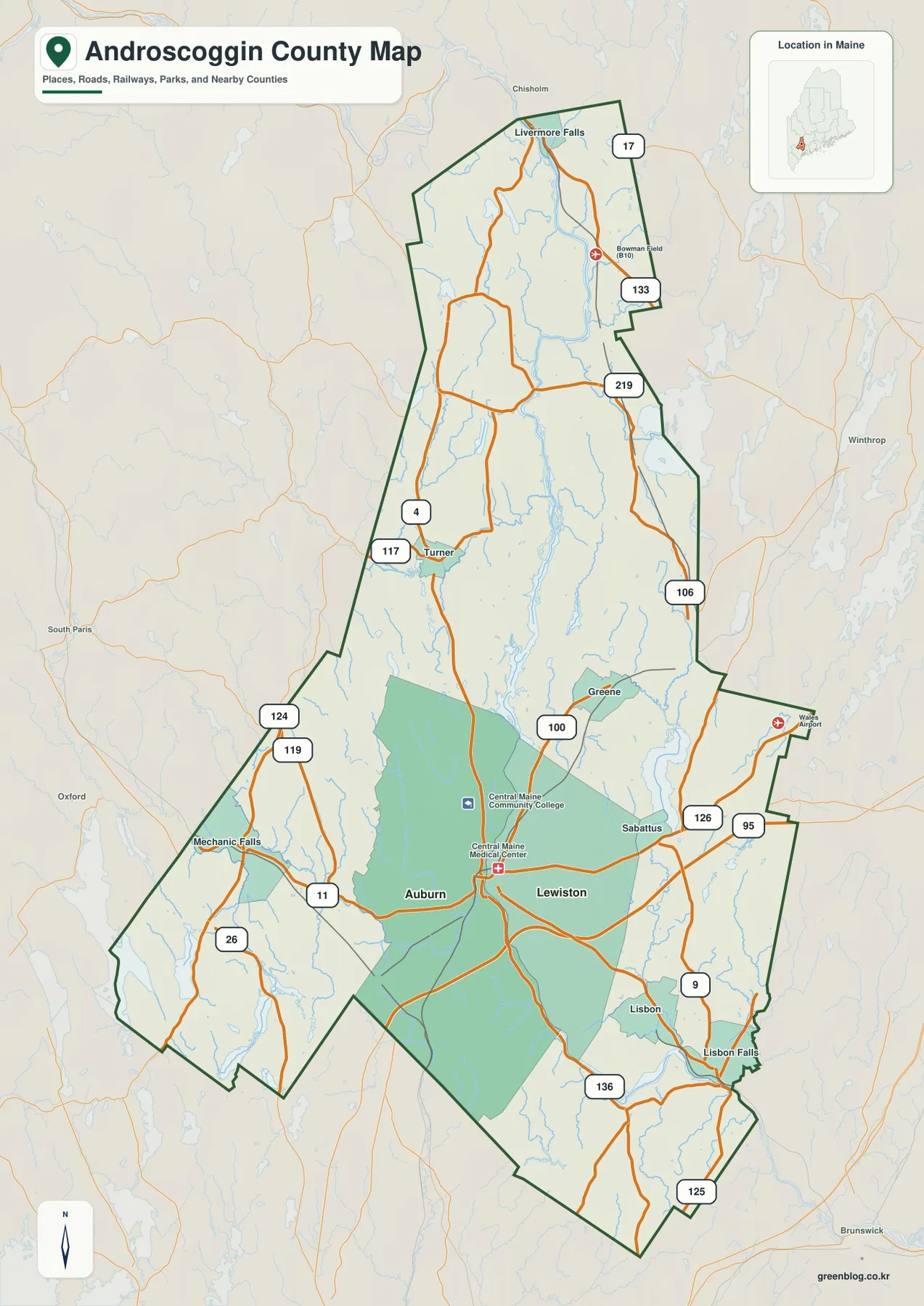
The full county map makes the southern road network immediately visible. Lewiston and Auburn occupy the broad lower portion of the county, where several numbered routes converge or pass close to one another. This is also where the county outline widens, so the combination of boundary and road labels provides a stronger sense of place than a city name alone.
Route 4 is especially useful for tracing the county northward. It runs from the Auburn area toward Turner and continues in the direction of Livermore Falls, giving the long county shape a clear geographic reference. Route 117 appears around Turner, while Routes 17 and 133 are labeled farther north near the Livermore Falls end of the map.
The eastern side has a different pattern. Route 126 leads from the Lewiston area toward Sabattus, I-95 is marked nearby, and Route 9 continues through the southeastern side. Lisbon and Lisbon Falls sit farther south and east, with Routes 136 and 125 helping identify the narrow lower extension of the county.
West of Auburn, Route 11 points toward Mechanic Falls. Routes 119, 124, and 26 appear near the irregular southwestern boundary, where the county line bends several times instead of forming a simple rectangle. That combination of roads and boundary turns is useful when a place looks close to Auburn on a regional map but actually lies near a county edge.
Additional labels such as Routes 100, 106, and 219 help fill in the central and eastern corridors without changing the basic pattern. The south contains the densest concentration of roads and named communities, while the north is longer and visually more open. For general orientation, it is usually easier to identify Lewiston–Auburn, Turner, and Livermore Falls first and then use the route numbers as secondary clues.
This map should be treated as a county reference map rather than a navigation product. It is useful for comparing municipal locations, major roads, and the county boundary on one page, but it does not replace current turn-by-turn directions, parcel mapping, or legal boundary records. Its strength is the way it shows the relationship between the busy southern core and the elongated northern section.
Why the county’s major-city pattern is concentrated in the south
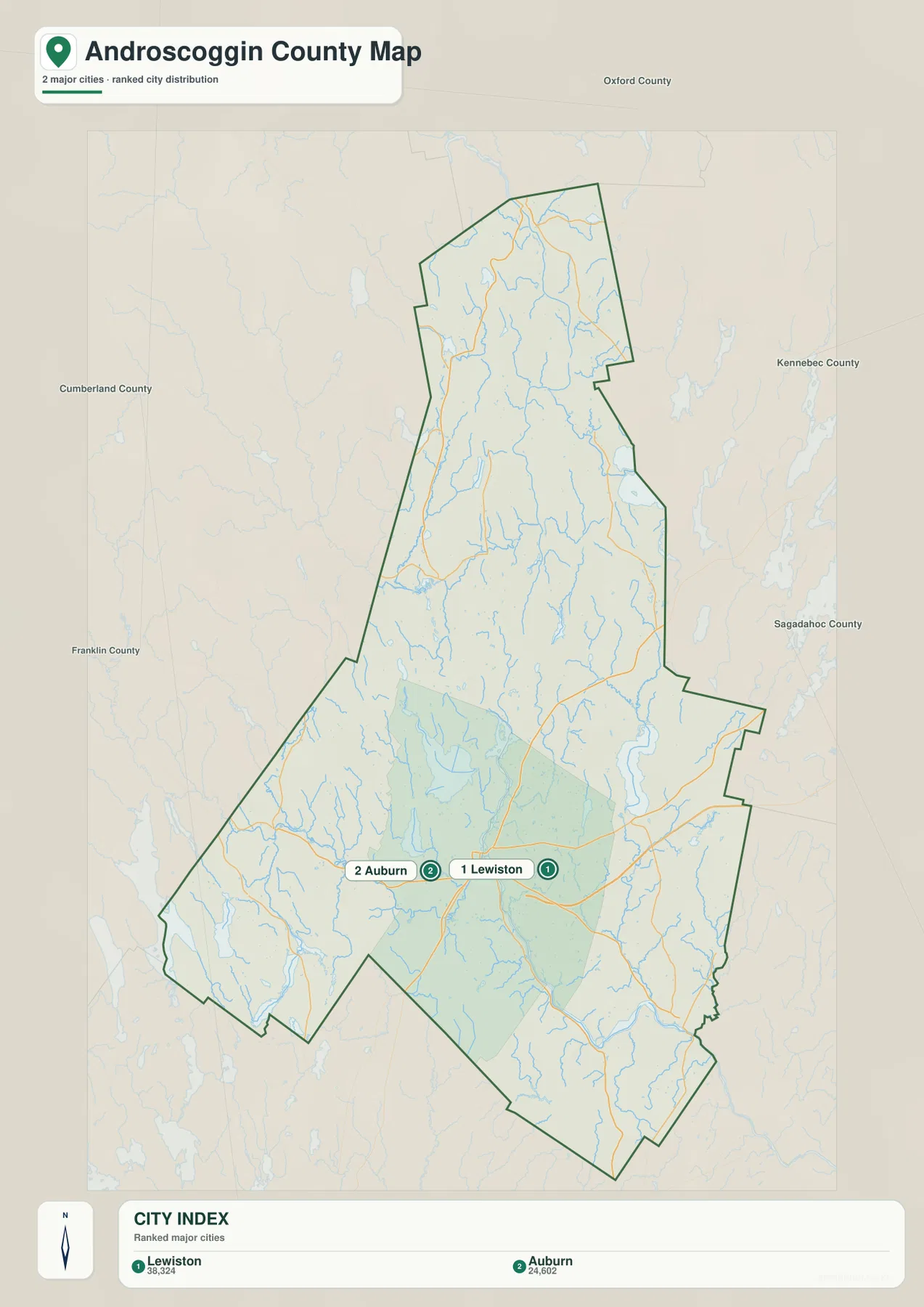
The city-distribution map removes most of the route detail and highlights a simpler fact: the two ranked major cities are both in the south-central part of Androscoggin County. Lewiston is labeled first and Auburn second, and their markers sit very close together. The rest of the county extends far north beyond this paired urban center without another major-city marker of the same type.
The city index printed on the map shows values of 38,324 for Lewiston and 24,602 for Auburn. Those numbers are part of the supplied map index and should not be treated as a claim about current population without a stated reference year. The more durable geographic takeaway is the concentration: the county’s major urban presence is clustered in one southern area rather than distributed evenly from north to south.
Auburn’s role as county seat adds an administrative reason to recognize the pair, but the map itself also shows why Lewiston matters to the same orientation. Roads cross and spread around both cities, and the Androscoggin River runs between them. Looking at the pair together provides a practical geographic anchor before moving outward to smaller places such as Turner, Greene, Sabattus, Lisbon, Mechanic Falls, and Livermore Falls.
The simplified city view is particularly useful when the county outline is the main subject. Without dozens of route labels competing for attention, it is easy to see how much land lies north of the Lewiston–Auburn cluster. That proportion explains why a person can understand the county’s urban center correctly and still underestimate the distance to its northern communities.
For classroom work or a presentation, this map can introduce the settlement pattern before the detailed road map is shown. It gives the audience a clear visual question—why are the major cities together in the south while the county continues so much farther north? The road and water maps then provide additional context without requiring the city map to carry information it was not designed to show.
The Androscoggin River system, ponds, and broad relief
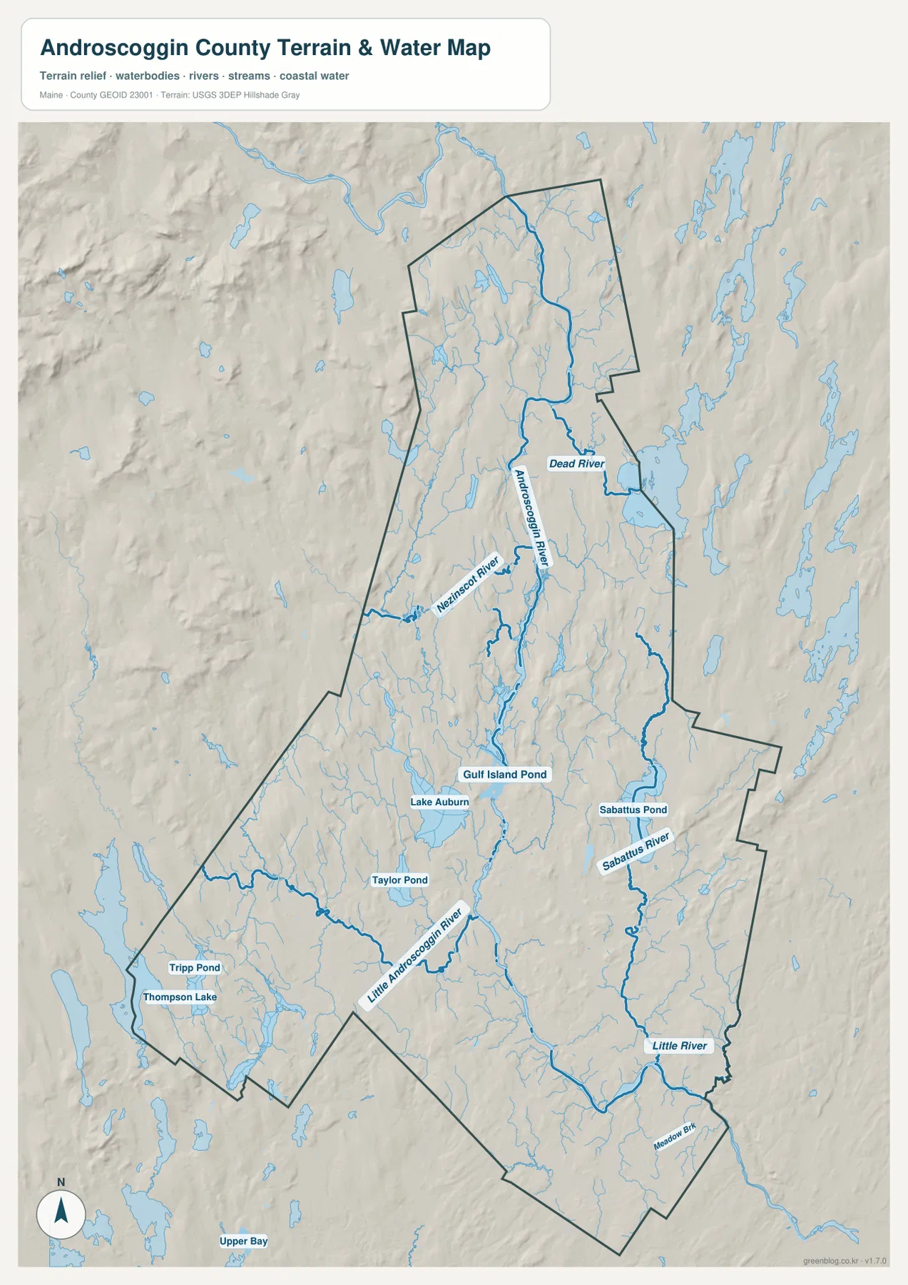
The terrain-and-water view shifts attention away from transportation and toward the natural features that connect the county. The Androscoggin River is the dominant line, entering from the north and winding through the central corridor toward Lewiston and Auburn. Its path gives the long north–south county shape a second organizing feature beyond Route 4.
Two named tributaries stand out in the northern and central portions of the map. The Nezinscot River approaches from the west, while the Dead River is labeled on the eastern side near the main river system. Numerous smaller streams feed the same landscape, producing a network that is much more intricate than the major-road map suggests.
Large water bodies become stronger landmarks toward the southern half. Lake Auburn is easy to spot just north of Auburn, and Gulf Island Pond lies farther north along the Androscoggin corridor. Sabattus Pond anchors the eastern side and connects visually with the Sabattus River, while Taylor Pond and Tripp Pond appear farther west.
The southwestern edge also includes Thompson Lake near the county boundary and the Little Androscoggin River crossing toward the Auburn side of the county. In the southeast, the Little River and Meadow Brook are labeled near the lower boundary. These names matter because several waterways have similar-sounding names; following the actual blue lines is more reliable than trying to infer their relationships from names alone.
Shaded relief provides a broad sense of hills and valleys without assigning exact elevations. The river corridors appear as lower pathways through a rolling landscape, while more pronounced relief is visible around parts of the outer county and surrounding region. That background helps explain why waterways bend through the county instead of following straight lines, but it should not be interpreted as survey-grade topography.
The water map is equally limited in other technical ways. It does not show FEMA flood-zone boundaries, current stream gauge readings, safe boating depth, dam operations, legal access, or water-quality conditions. Those questions require current information from agencies such as USGS, FEMA, the State of Maine, or the relevant local authority.
For regional study, however, the combination of water and relief is valuable. Lewiston and Auburn can be understood as cities on the Androscoggin River, Lake Auburn becomes a prominent landmark immediately to the north, and the tributaries explain how the central valley is connected to the east and west. The same county that looks road-centered in the first map becomes river-centered in this view.
Using the maps for print, study, and regional orientation
A useful way to work with the set is to begin with a geographic question instead of trying to read every label at once. If the goal is to locate communities or follow major routes, start with the boundary-and-road view. If the main question is why Lewiston and Auburn dominate the county’s urban pattern, the simplified city view communicates that relationship more directly.
Natural features call for a different approach. The terrain-and-water view is better for tracing the Androscoggin River, locating Lake Auburn or Sabattus Pond, and seeing where tributaries cut across the county. Comparing that map with the road layer can also explain why two places that seem close on a simple outline may be separated by river corridors, local relief, or an indirect road pattern.
The embedded WebP images are intended for quick viewing on the page. The downloadable JPG originals are 3638 by 2572 pixels each, preserving more label detail for printing and larger displays. The ZIP contains the county map, the city-distribution map, and the terrain-and-water map as separate files, so there is no need to print every layer when only one type of information is needed.
These maps are general geographic references rather than live operational data. Road construction, legal boundaries, emergency conditions, flood information, and other time-sensitive details can change or require a more authoritative source. Used within that scope, the set provides a clear way to compare the southern Lewiston–Auburn center, the long northern extension, and the river-and-pond network that runs through Androscoggin County.
Frequently Asked Questions
Why are Lewiston and Auburn shown so close together on the county maps?
The two cities are adjacent in southern Androscoggin County and are separated by the Androscoggin River. Auburn is the county seat, while Lewiston is the larger of the two entries in the supplied city index. Because roads, settlement, and the river corridor all converge around them, using Lewiston and Auburn together as an orientation point makes the rest of the county easier to understand.
Does the terrain-and-water map show exact elevation or flood risk?
No. The shaded relief shows broad terrain differences, and the blue features identify rivers, streams, lakes, and ponds at a reference-map level. It does not provide survey-grade elevation, detailed slope measurements, FEMA flood zones, current water levels, or navigation conditions. Use the relevant USGS, FEMA, Maine, or local agency source when a decision depends on current or precise measurements.
Map File Information
Download the high-resolution JPG maps described on this page in one ZIP archive.
- Included Files: county map, city distribution map, terrain-and-water map
- Printable Size: 3638 × 2572 pixels each
Related Maps
Sources and references
- Androscoggin County, Maine – Official Website
- Maine Secretary of State – County Information
- U.S. Census Bureau – TIGER/Line Shapefiles
- USGS – National Hydrography
- USGS – 3D Elevation Program
Green Map creates custom-edited map images using open geographic data sources such as geoBoundaries, Natural Earth, OpenStreetMap, and government open data. These maps are edited visual materials, not raw data files, and are provided for education, documents, presentations, and graphic reference.