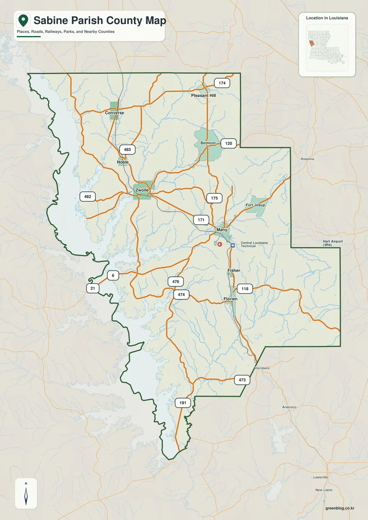
Sabine Parish occupies Louisiana’s western edge, where Many serves as the central town and Toledo Bend Reservoir forms a dramatic water boundary with Texas. Zwolle and Noble lie to the northwest of Many, Florien is farther south, and Converse and Pleasant Hill anchor the upper parish. U.S. 171 provides the strongest north-south road reference, while LA 6 and numerous state routes connect the interior to the reservoir side. This page explains those visible settlement, road, and water relationships, and the matching high-resolution JPG map files can be downloaded together in a ZIP.
Many is the parish seat. Louisiana’s official Sabine Parish profile lists Many and Zwolle as towns and Converse, Fisher, Florien, Noble, and Pleasant Hill as villages. The supplied general map also labels Belmont and Fort Jesup, giving useful extra reference points east and northeast of Many. Once Many is located, the parish becomes easier to divide into the northern communities, the U.S. 171 corridor, the southern Florien section, and the reservoir-heavy west.
Table of Contents
U.S. 171 gives Many, Zwolle, and Florien a clear north-south spine
The general map shows U.S. 171 as the most useful road for organizing the central parish. It passes through the Zwolle area, reaches Many, and continues toward Florien. LA 175 branches north from the Many side, while LA 6 runs west toward the Texas border and Toledo Bend area. South of Many, LA 118 and LA 473 provide additional references as the parish narrows toward its lower end.
Several local routes help distinguish the northern and western sections. LA 482 reaches west from the Zwolle area, LA 483 appears near Noble, and LA 174 crosses the upper parish around Converse and Pleasant Hill. LA 120 serves the Belmont side, while LA 21 and LA 6 move toward the reservoir in the southwest. Around Florien, LA 474 and LA 476 add east-west links. Reading these roads after locating U.S. 171 prevents the smaller route numbers from becoming overwhelming.
Pleasant Hill, Converse, and Noble separate the northern parish into distinct pockets
The northern parish does not have one continuous settlement corridor. Pleasant Hill lies toward the northeast, Converse is farther northwest, and Noble sits below them closer to the U.S. 171 corridor. The spacing between these places is filled with local roads and streams, so the upper parish reads as a collection of small communities rather than a suburban extension of Many.
Belmont appears below Pleasant Hill, and Fort Jesup is labeled northeast of Many. The National Park Service places Fort Jesup State Historic Site about six miles northeast of Many, just south of State Highway 6. That location makes the historic site a useful map landmark as well as a cultural reference, especially for readers trying to connect the Many area with the eastern side of the parish.
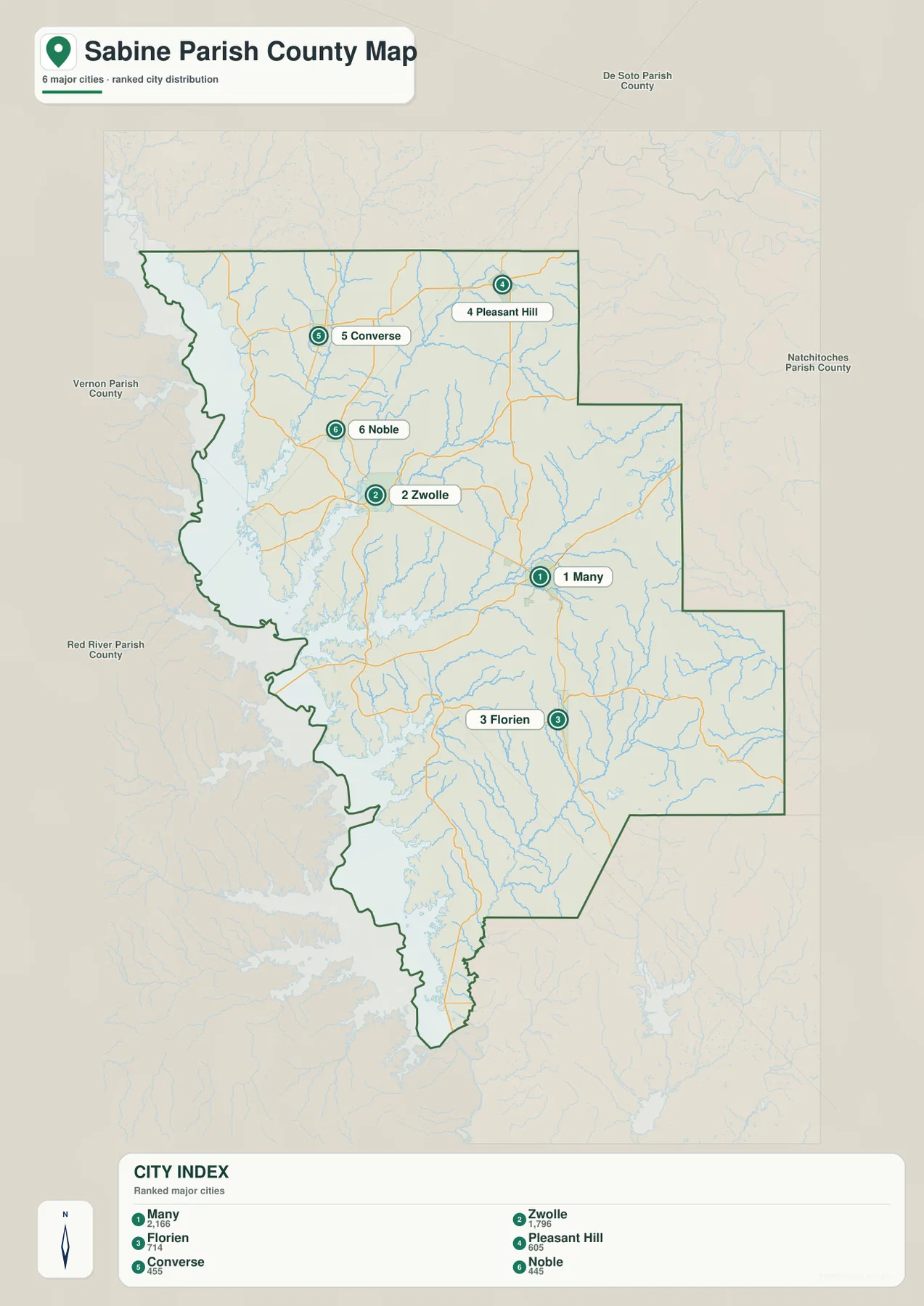
The ranked city index compares six communities without implying distance
The city graphic ranks six selected places: Many is number 1, Zwolle 2, Florien 3, Pleasant Hill 4, Converse 5, and Noble 6. Their locations spread across much of the parish. Many occupies the center, Zwolle is northwest, Florien is south, and Pleasant Hill and Converse are in the north. The index therefore highlights the parish’s dispersed settlement pattern rather than a single dense cluster.
The numbers are not straight-line or driving distances. Fisher and Belmont are also visible on the general map but are not included in the six-place ranking. Use the city index when you want a clean comparison of the selected communities, and use the general map when roads, additional places, and the full parish boundary are important.
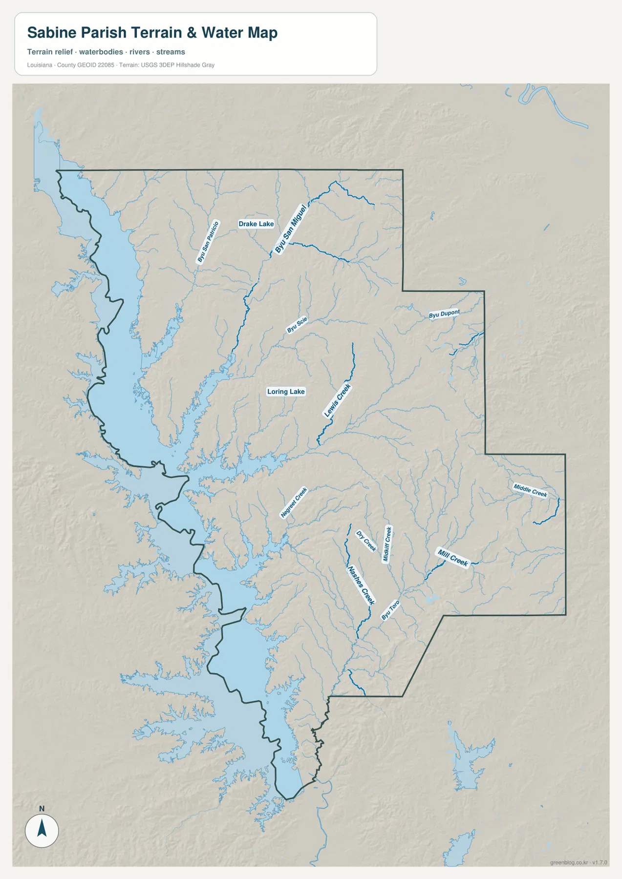
Toledo Bend Reservoir dominates the western edge of the parish
The terrain-and-water map is defined by the huge Toledo Bend Reservoir along the western boundary. The lake follows the Sabine River at the Louisiana–Texas line, and long arms of water reach far into the parish. The Sabine River Authority of Louisiana describes Toledo Bend as a joint Louisiana–Texas project with roughly 186,000 surface acres at normal pool. That scale explains why the western parish boundary looks so irregular and water-filled.
Near Zwolle and west of Many, long reservoir inlets extend deep into the interior. Farther south, the open water broadens again and surrounds narrow peninsulas along the parish edge. In this part of Sabine Parish, the shape of Toledo Bend is often a more useful location clue than the nearest road number because shoreline branches create a complex western outline.
Bayou San Miguel, Negreet Creek, and Bayou Toro connect the interior to the reservoir
The northern interior contains several named waterways feeding toward the larger western system. Bayou San Patricio and Bayou San Miguel are labeled near the upper parish, with Drake Lake between and around their drainage areas. Farther south, Loring Lake and Lewis Creek provide strong central references. These streams and lakes show how the parish interior drains toward the reservoir through many narrow channels.
In the lower half, Negreet Creek reaches toward the western reservoir, while Masters Creek, Mill Creek, and Middle Creek organize the southeast. Bayou Toro is one of the strongest named southern waterways, and Bayou Dupont appears in the northeast. The water map is designed for geographic reference only. It does not provide flood-zone status, water depth, navigability, shoreline ownership, or legal property boundaries.
A Many-first road view and a Toledo Bend-first water view make the parish easier to read
For roads and settlements, begin with Many and use U.S. 171 to connect Zwolle to the north and Florien to the south. Add Pleasant Hill, Converse, and Noble to organize the upper parish, then follow LA 6 toward the reservoir side. This sequence creates a simple framework before smaller routes such as LA 174, LA 120, LA 482, LA 474, and LA 473 are added.
For water features, reverse the approach and begin with Toledo Bend Reservoir. From the western lake, move inward to Bayou San Miguel and Drake Lake in the north, Loring Lake and Lewis Creek near the middle, and Negreet Creek and Bayou Toro farther south. The general map is best for roads and communities, the city index for the six ranked settlements, and the water map for the reservoir shoreline and tributary network.
Original JPG files preserve the fine shoreline and tributary detail
The downloadable ZIP contains the original JPG files corresponding to the three previews on this page: the general parish map, the ranked city map, and the terrain-and-water map. Each original image is 2572 by 3638 pixels, providing more room to inspect route numbers, community labels, creek names, and the highly detailed Toledo Bend shoreline than the web preview. The files are useful for printing, classroom material, presentation slides, and personal geographic reference.
Choose the general map when Many, Zwolle, Florien, the road network, and the parish outline need to appear together. Use the city index for a quick comparison of the six selected communities. The water map is the better choice for Toledo Bend Reservoir, Bayou San Miguel, Negreet Creek, Bayou Toro, and the many smaller tributaries. These are general reference maps rather than legal boundary, survey, flood-risk, or real-time navigation products.
Frequently Asked Questions
What is the parish seat of Sabine Parish?
Many is the parish seat and the clearest central reference on the supplied map. U.S. 171, LA 6, and LA 175 meet around the area, with Zwolle to the northwest, Florien to the south, and Pleasant Hill and Converse in the northern parish.
Do the numbers 1 through 6 on the city map show distance from Many?
No. They are rankings for Many, Zwolle, Florien, Pleasant Hill, Converse, and Noble. The graphic does not show straight-line or driving mileage, so use the general road map and current navigation information when distance or travel time matters.
Can the Toledo Bend water map be used for flood, boating, or property decisions?
No. It is a general geographic reference showing Toledo Bend Reservoir and nearby bayous, creeks, and lakes. It does not provide flood-zone ratings, water depth, navigation clearance, shoreline rights, or legal property boundaries. Those decisions require current information from the Sabine River Authority and other responsible agencies.
Map File Information
The ZIP contains the original high-resolution JPG files corresponding to the general parish map, ranked city map, and terrain-and-water map shown on this page.
- Included Files: parish map JPG, ranked city map JPG, terrain-and-water map JPG
Related Maps
Sources and references
For parish-seat and municipality information, see the Louisiana.gov Sabine Parish Profile. Toledo Bend Reservoir information is available from the Sabine River Authority of Louisiana, and Fort Jesup context is available from the National Park Service. Road maps are available from Louisiana DOTD, general boundary data from the U.S. Census Bureau TIGER/Line Shapefiles, and national water-feature data from USGS National Hydrography.
Green Map creates custom-edited map images using open geographic data sources such as geoBoundaries, Natural Earth, OpenStreetMap, and government open data. These maps are edited visual materials, not raw data files, and are provided for education, documents, presentations, and graphic reference.