Richland Parish in northeastern Louisiana is easiest to understand from Rayville, where the east-west U.S. 80 corridor meets U.S. 425. Delhi lies near the eastern edge, Start sits west of Rayville, and Mangham is farther south. Away from those settlements, the map is crossed by the Boeuf River, creeks, bayous, small lakes, and ponds that occupy much of the open rural landscape. This page explains those visible road and water relationships, and the matching high-resolution JPG map files can be downloaded together in a ZIP.
Rayville is the parish seat. Louisiana’s official Richland Parish profile identifies Rayville and Delhi as towns, Mangham as a village, and Start as an unincorporated community. Their locations create a simple first framework for the map: Rayville in the central corridor, Delhi to the east, Start to the west, and Mangham to the south. Once those four places are located, the parish’s road branches and dense drainage network become much easier to follow.
Table of Contents
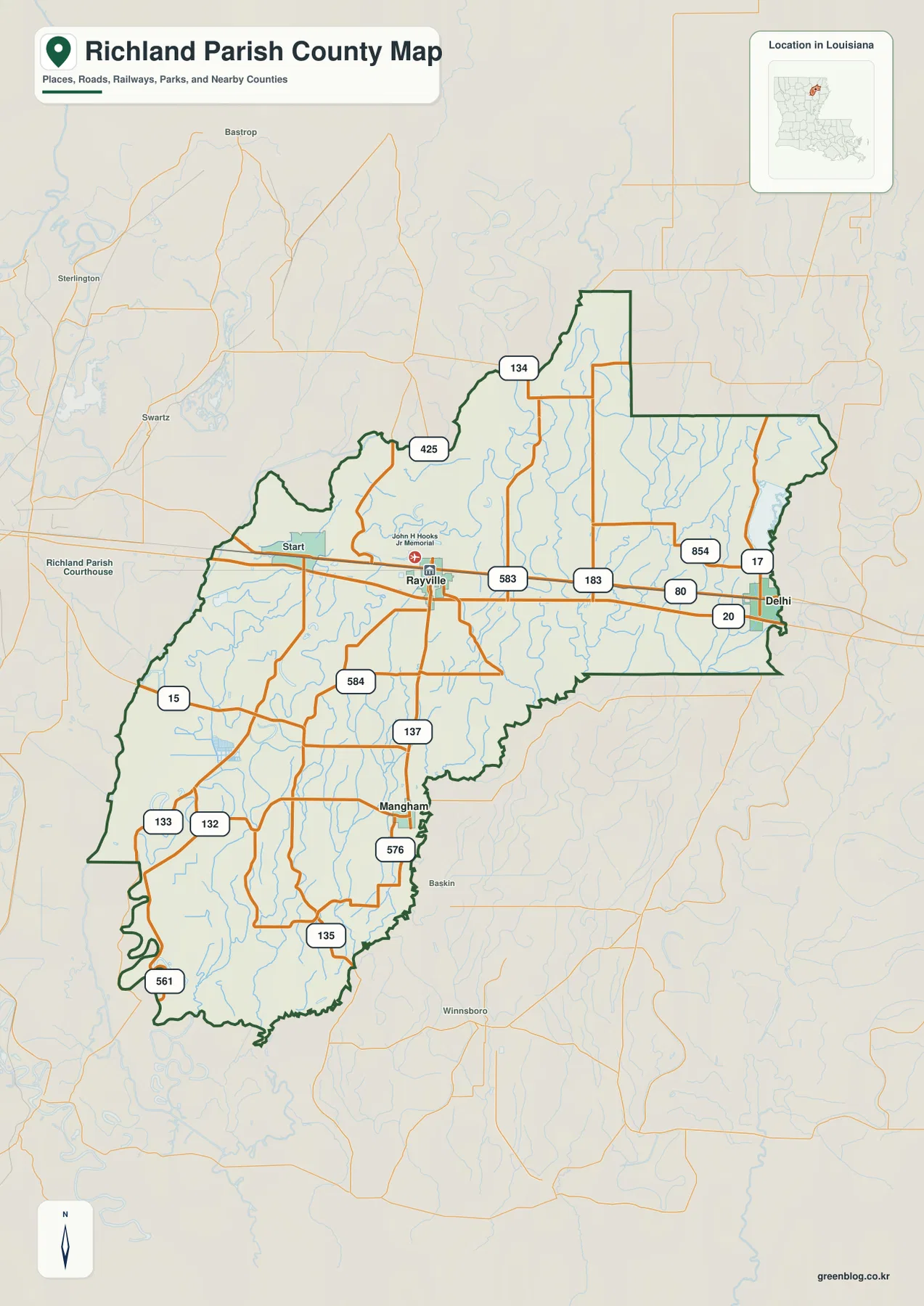
Rayville is the road reference where U.S. 80 meets U.S. 425
The general map places Rayville at the strongest road junction in the parish. U.S. 80 runs east-west through the central corridor, linking Start on the west side with Delhi near the eastern boundary. U.S. 425 crosses the same area north-south, while LA 583 and LA 584 provide additional connections around Rayville. This layout makes the parish seat an obvious first point for reading both the road map and the settlement pattern.
Farther north, LA 134 provides another east-west reference. Near Delhi, LA 17 and LA 854 add routes toward the eastern side. The southern half contains LA 137, LA 576, and LA 135 around the Mangham area, while LA 15, LA 132, LA 133, and LA 561 appear farther west and southwest. Rather than memorizing every route, it is easier to establish the U.S. 80 and U.S. 425 cross first and then add the state highways needed for a particular part of the parish.
Delhi and Start define the U.S. 80 corridor while Mangham anchors the south
Delhi is the clearest eastern settlement on the map and lies close to the parish boundary along U.S. 80. LA 17 and LA 854 add local road references around town, while numerous narrow waterways cross the surrounding countryside. Start appears on the same U.S. 80 corridor west of Rayville, making it a useful intermediate reference between the parish seat and the western edge.
Mangham occupies a different branch of the settlement pattern. It lies south of Rayville near LA 137 and LA 576, with LA 132 and LA 133 farther west. The Rayville–Delhi section has a strong east-west highway identity, but the Mangham side is more dispersed, with local roads and small drainage lines spreading across the southern parish. That contrast is easy to miss when only the main highway is considered.
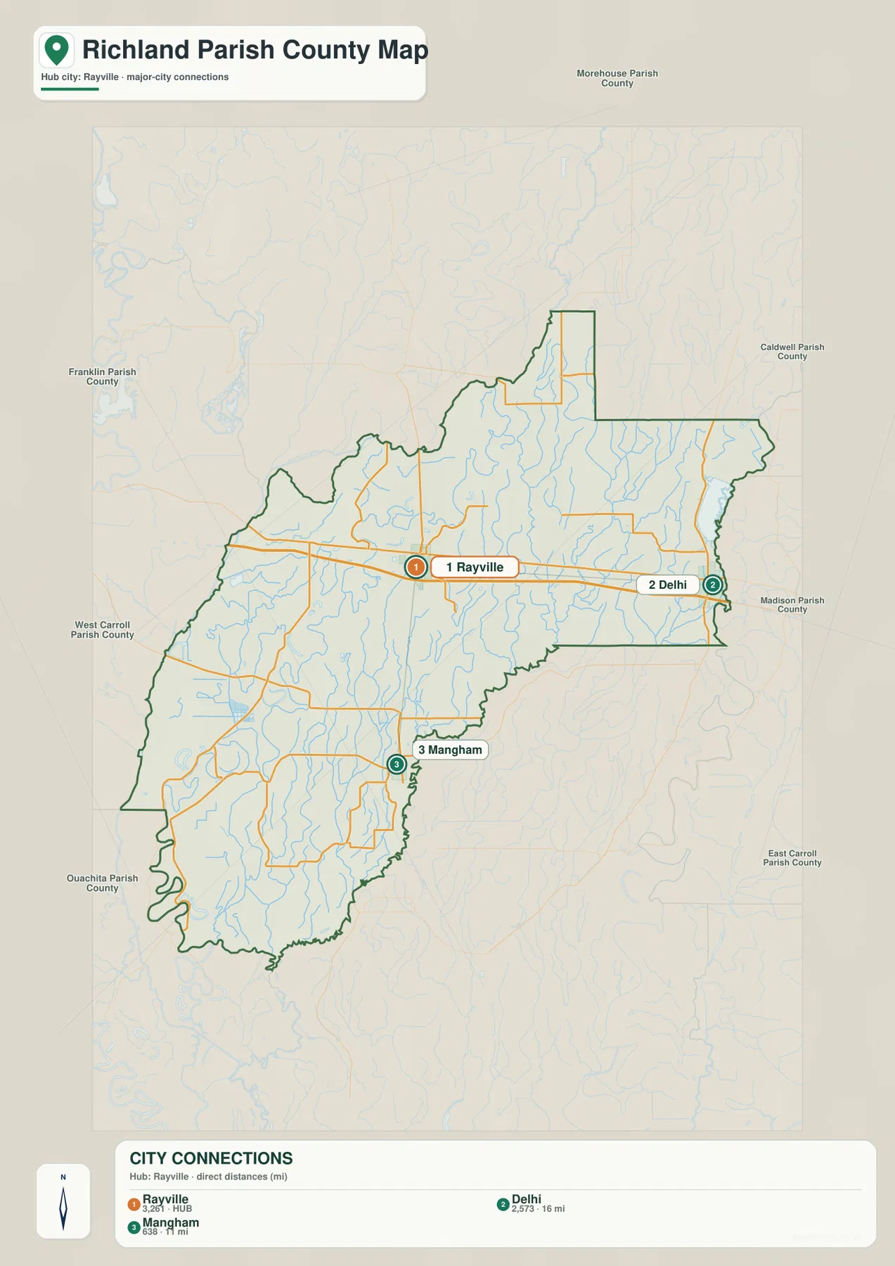
Straight-line connections from Rayville compare Delhi and Mangham
The city-connections graphic uses Rayville as the hub and draws direct lines to Delhi and Mangham. The legend gives approximately 16 miles to Delhi and 11 miles to Mangham. These are straight-line distances between the mapped points, not road mileage. Driving distance and travel time will differ because vehicles must follow the actual U.S. and state highway network.
The directions are just as informative as the numbers. Delhi lies east of Rayville along the U.S. 80 corridor, while Mangham is south of the parish seat. The simplified connections view therefore shows two different branches from the central town instead of implying that the three places sit on a single road. It works well when a presentation or lesson needs the basic relationship without the full set of route labels.
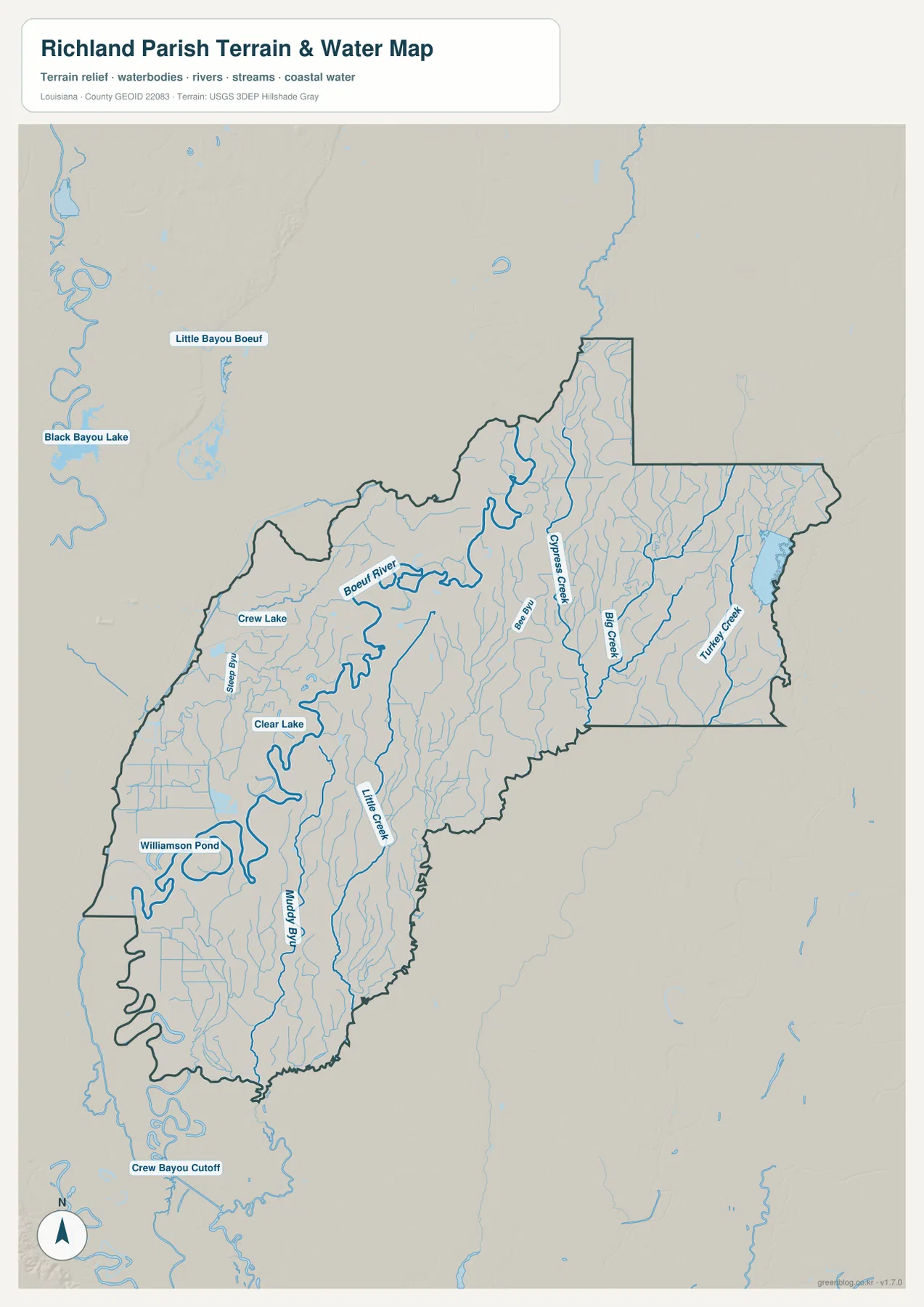
The Boeuf River winds through the western interior beside lakes and bayous
The terrain-and-water map shifts attention toward the Boeuf River, the most prominent named watercourse inside the parish. It meanders through the northwestern and west-central interior, with many smaller channels joining or paralleling it. Crew Lake lies nearby, and farther south Clear Lake and Williamson Pond provide additional landmarks in the broad low-lying area around the river.
Slagle Bayou is labeled on the western side, while Muddy Bayou continues through the southern interior. Little Creek provides another north-south water reference closer to the middle. These features are much less obvious on the road map, where route labels dominate, but the water view reveals how heavily the western half is crossed by winding channels and shallow-looking water features.
Cypress Creek, Big Creek, and Turkey Creek organize the eastern half
The eastern half has a different drainage pattern. Cypress Creek runs through the north-central and eastern interior, with Big Creek farther east and Turkey Creek close to the parish’s eastern side. Numerous thin tributaries fill the spaces between them. Around the Delhi side of the parish, these creeks become more useful geographic references than settlement labels once you move away from U.S. 80.
Bee Bayou is labeled west of Cypress Creek and helps bridge the visual gap between the Boeuf River system and the eastern creeks. Little Bayou Boeuf and Black Bayou Lake are visible outside the parish to the northwest, providing regional context without being the main focus of the page. The blue lines and water bodies are general location references only; they do not provide flood-zone status, water depth, navigability, or legal property boundaries.
Use Rayville for roads and the Boeuf River–Cypress Creek split for water features
A practical road-first approach begins at Rayville. Follow U.S. 80 west to Start and east to Delhi, then use U.S. 425 to establish the north-south direction before adding Mangham in the south. Once that framework is in place, state routes such as LA 134, LA 137, LA 17, and LA 15 are easier to locate without making the map feel crowded.
For water features, begin with the Boeuf River in the west and Cypress Creek farther east. Big Creek and Turkey Creek then divide the eastern side, while Slagle Bayou, Muddy Bayou, Crew Lake, Clear Lake, and Williamson Pond add detail to the western and southern sections. The general map is best for settlements and roads, the city-connections map for the two direct links from Rayville, and the water map for the parish’s dense drainage network.
Original JPG files make small route and stream labels easier to inspect
The downloadable ZIP contains the original JPG files corresponding to the three previews on this page: the general parish map, the city-connections map, and the terrain-and-water map. Each original image is 2572 by 3638 pixels, giving more room to enlarge route numbers, community names, creek labels, and small water features than the web preview. The files are useful for printing, classroom material, presentation slides, and personal geographic reference.
Choose the general map when Rayville, Delhi, Start, Mangham, and the road network need to appear together. Use the city-connections graphic when the direction and straight-line distance from Rayville to Delhi and Mangham are the main subject. The water map is the better choice for the Boeuf River, Cypress Creek, Big Creek, bayous, lakes, and ponds. These are general reference maps rather than legal boundary, survey, flood-risk, or real-time navigation products.
Frequently Asked Questions
What is the parish seat of Richland Parish?
Rayville is the parish seat and the clearest road hub on the supplied map. U.S. 80 and U.S. 425 meet in the Rayville area, while Start lies to the west, Delhi to the east, and Mangham to the south.
Are the 11- and 16-mile labels driving distances?
No. The city-connections map uses straight-line distances from Rayville: about 11 miles to Mangham and 16 miles to Delhi. Actual road mileage depends on the route and exact starting point, so current navigation information is better for trip planning.
Can the Boeuf River and creek map be used as a flood or navigation map?
No. It is a general geographic reference showing the Boeuf River, Cypress Creek, Big Creek, Turkey Creek, bayous, lakes, and ponds. It does not provide flood-zone classifications, water depth, navigability, levee protection, or legal property boundaries. Those decisions require current specialized data.
Map File Information
The ZIP contains the original high-resolution JPG files corresponding to the general parish map, city-connections map, and terrain-and-water map shown on this page.
- Included Files: parish map JPG, city-connections map JPG, terrain-and-water map JPG
Related Maps
Sources and references
For parish-seat and municipality information, see the Louisiana.gov Richland Parish Profile. Current state-road information is available through the Louisiana DOTD Richland Parish page. General boundary data are documented by the U.S. Census Bureau TIGER/Line Shapefiles, and national water-feature data are documented through USGS National Hydrography.
Green Map creates custom-edited map images using open geographic data sources such as geoBoundaries, Natural Earth, OpenStreetMap, and government open data. These maps are edited visual materials, not raw data files, and are provided for education, documents, presentations, and graphic reference.