Red River Parish in northwestern Louisiana is a small-settlement parish organized around Coushatta and the broad Red River corridor. Hall Summit lies to the north, Martin to the east, and Edgefield northeast of Coushatta, while U.S. 71, U.S. 84, LA 1, and several state routes provide the main road references. The terrain-and-water map adds another layer, showing the Red River, Grand Bayou, creeks, and a chain of small lakes along the river corridor. This page explains those local relationships, and the matching high-resolution JPG map files can be downloaded together in a ZIP.
Coushatta is the parish seat and the town that serves as the clearest starting point on the supplied maps. Louisiana’s official Red River Parish profile lists Coushatta as the town and Edgefield, Hall Summit, and Martin as villages. The four communities are spread in different directions rather than forming one dense urban corridor, so road and water landmarks are especially useful for understanding how the parish fits together.
Table of Contents
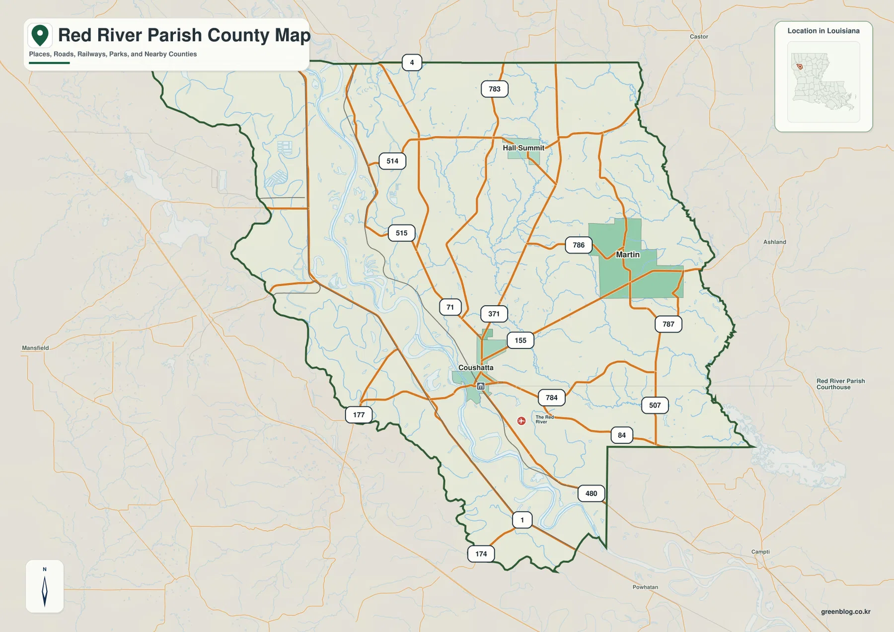
Coushatta is the road junction where U.S. 71, U.S. 84, and LA 155 become easy to follow
The general parish map places Coushatta slightly south of center, at the point where several important roads converge. U.S. 71 runs north-south through the central corridor, U.S. 84 provides a major eastward and southeastern reference, and LA 1 continues toward the lower parish. LA 155 reaches east and northeast from Coushatta. Because the road system branches in several directions, using Coushatta as the fixed point is much easier than trying to read the route network from the parish boundary inward.
Farther north, LA 4 crosses near the top of the parish and LA 783 appears in the upper interior. LA 514 and LA 515 help locate the Hall Summit area, while LA 786 and LA 787 serve the Martin side. U.S. 84 and LA 507 are useful in the southeast, and LA 480, LA 174, and LA 177 help define the lower and western sections. For current construction, closures, or live travel conditions, Louisiana DOTD remains the appropriate source.
Hall Summit and Martin provide clear northern and eastern references
Hall Summit sits in the upper middle of the parish and is the easiest named community to use when locating the northern section. LA 514 and LA 515 connect the area back toward U.S. 71, while LA 4 provides a broad east-west reference closer to the northern boundary. This part of the map contains fewer developed blocks than Coushatta and many more small stream lines, so the roads and drainage network share equal importance for orientation.
Martin occupies the east-central side near LA 786 and LA 787. There is no continuous urban strip between Coushatta and Martin; instead, local roads and narrow waterways fill most of the intervening space. Edgefield appears in the city index as another incorporated community northeast of Coushatta, even though it is less visually prominent on the detailed road map. Comparing the two map types helps prevent a small village from disappearing among the route labels.
The city index ranks four communities without turning the numbers into mileage
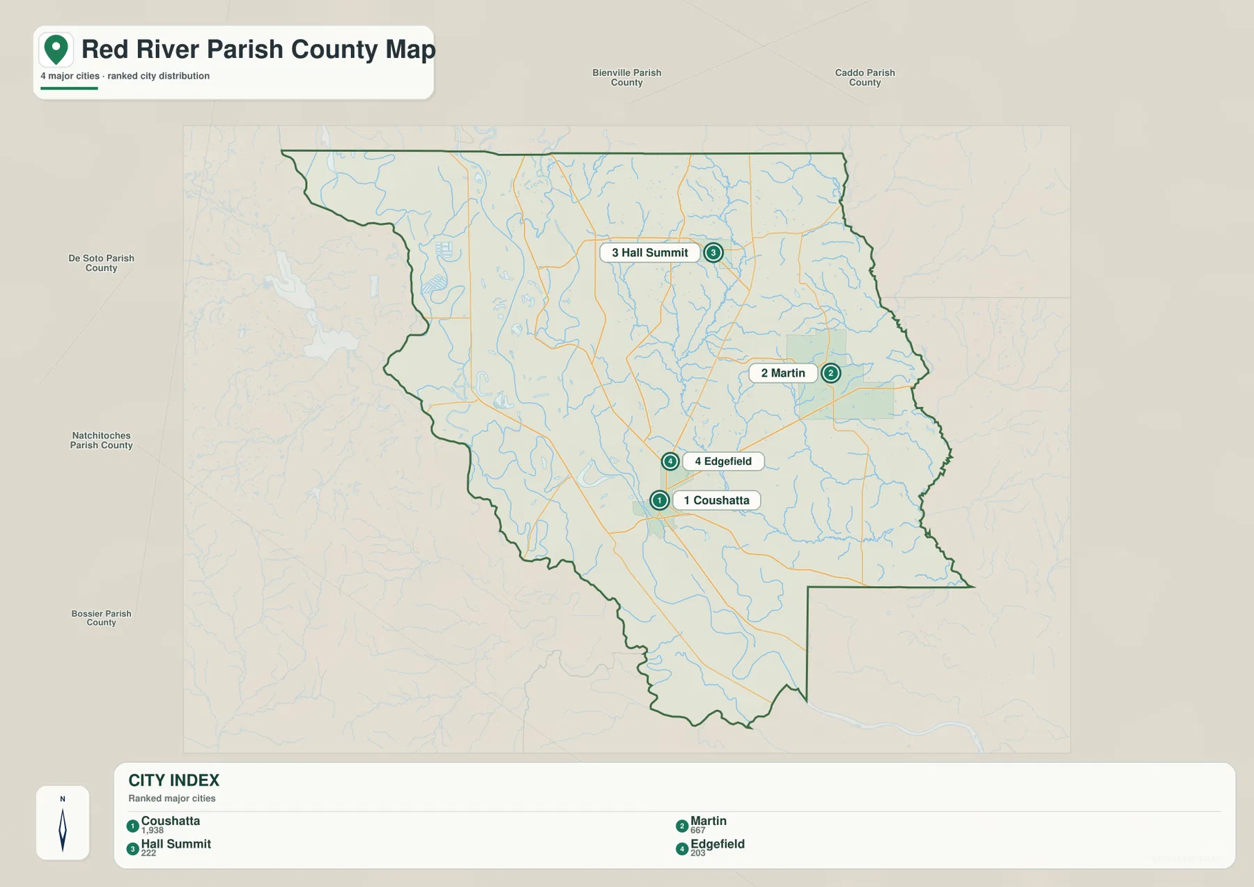
The city graphic is a ranked distribution map rather than a distance diagram. Coushatta is number 1, Martin 2, Hall Summit 3, and Edgefield 4. Their placement shows a dispersed pattern: Coushatta is near the center-south, Hall Summit is north, Martin is east, and Edgefield lies northeast of Coushatta. The simplified view makes the geography of the four incorporated communities easier to compare than the more detailed road map.
The ranking numbers do not represent straight-line distance, driving mileage, or travel time from Coushatta. When actual route distance matters, the general map and a current navigation source are more appropriate. The city index is best used for a quick classroom, presentation, or reference view of where the selected communities sit inside the parish.
The Red River organizes the western half of the parish
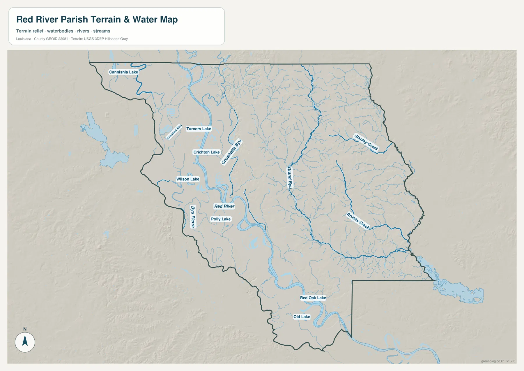
The terrain-and-water map makes the Red River the strongest geographic reference. It enters from the northwest, follows a winding course through the west-central part of the parish, and continues south past the Coushatta area. On the road map, U.S. 71 and the local route network attract more attention; on the water view, the broad river and its bends explain why the western side has so many lakes, abandoned channels, and low-lying water features.
Turners Lake, Crichton Lake, Wilson Lake, and Polly Lake are clustered around the river corridor in the central and northwestern portions. Farther south, Red Oak Lake and Old Lake sit near later bends of the Red River. These water bodies differ in size and form, but together they show that the parish’s river landscape is more complicated than a single channel running down the map.
Grand Bayou, Stanley Creek, and Brushy Creek define the eastern drainage
East of the Red River, Grand Bayou becomes one of the longest named water features. It runs through the central and eastern interior and is joined by a dense pattern of smaller tributaries. Stanley Creek is prominent in the northeast, while Brushy Creek curves across the southeast. Around Martin and the eastern boundary, these waterways provide better geographic anchors than town labels because the settlement pattern is sparse.
Coushatta Bayou and Bayou Pierre add more named channels on the western and central side of the parish. The terrain-and-water map is intended to show relative locations and connections, not flood risk or navigation conditions. Blue lines and lakes do not indicate flood-zone status, water depth, levee protection, navigability, or legal parcel boundaries, so those questions require current specialized information.
A west-river and east-creek approach makes the parish easier to read
For settlements and roads, begin with Coushatta and then place Hall Summit to the north, Martin to the east, and Edgefield to the northeast. U.S. 71 and U.S. 84 are the two largest first references, with LA 155, LA 514, LA 515, and LA 786 becoming useful once you focus on a particular section. This approach keeps the many smaller route numbers from overwhelming the map.
For water features, use the Red River as the western spine and Grand Bayou as the main interior reference. Turners, Crichton, Wilson, Polly, Red Oak, and Old lakes help locate the river lowlands, while Stanley Creek and Brushy Creek organize the eastern side. The general map is best for roads and community locations, the city index for the four ranked places, and the terrain-and-water map for the parish’s river, bayous, creeks, and lakes.
Original JPG files make small route and tributary labels easier to inspect
The downloadable ZIP contains the original JPG files corresponding to the three previews on this page: the general parish map, the ranked city map, and the terrain-and-water map. Each original image is 3638 by 2572 pixels, providing more room to enlarge route numbers, community labels, creek names, and small lake labels than the web preview. The files are useful for printing, classroom material, presentation slides, and personal geographic reference.
Choose the general map when Coushatta, the road network, and the parish boundary need to appear together. Use the city index for a quick comparison of Coushatta, Martin, Hall Summit, and Edgefield. The water map is the better choice for the Red River, Grand Bayou, eastern creeks, and the river-corridor lakes. These are general reference maps rather than legal boundary, survey, flood-risk, or real-time navigation products.
Frequently Asked Questions
What is the parish seat of Red River Parish?
Coushatta is the parish seat and the clearest road hub on the supplied map. U.S. 71, U.S. 84, and LA 155 provide useful references around town, while Hall Summit lies to the north, Martin to the east, and Edgefield to the northeast.
Do the numbers 1 through 4 on the city map represent distance from Coushatta?
No. They are rankings for Coushatta, Martin, Hall Summit, and Edgefield. The city graphic does not show straight-line or driving mileage, so use the general road map and current navigation information when distance or travel time matters.
Can the Red River and lake map be used as a flood-risk or navigation map?
No. It is a general geographic reference showing the Red River, Grand Bayou, creeks, and named lakes. It does not provide flood-zone classifications, water depth, navigability, levee protection, or legal property boundaries. Those decisions require current specialized information from the responsible agencies.
Map File Information
The ZIP contains the original high-resolution JPG files corresponding to the general parish map, ranked city map, and terrain-and-water map shown on this page.
- Included Files: parish map JPG, ranked city map JPG, terrain-and-water map JPG
Related Maps
Sources and references
For parish-seat and municipality information, see the Louisiana.gov Red River Parish Profile. Current state-road information is available through the Louisiana DOTD Red River Parish page. General boundary data are documented by the U.S. Census Bureau TIGER/Line Shapefiles, and national water-feature data are documented through USGS National Hydrography.
Green Map creates custom-edited map images using open geographic data sources such as geoBoundaries, Natural Earth, OpenStreetMap, and government open data. These maps are edited visual materials, not raw data files, and are provided for education, documents, presentations, and graphic reference.