Ouachita Parish in northeastern Louisiana is centered on the paired urban areas of Monroe and West Monroe, which sit on opposite sides of the Ouachita River and are tied together by I-20. Richwood lies south of Monroe, Sterlington is farther north, and communities such as Swartz, Lakeshore, Calhoun, and Claiborne spread outward from the central city corridor. This page explains those visible road and settlement relationships and then follows the river, lakes, creeks, and drainage channels shown on the water map. Matching high-resolution JPG originals are available together in a downloadable ZIP.
Monroe is the parish seat and the largest developed area on the supplied map, while West Monroe forms a closely connected urban counterpart across the river. Official Ouachita Parish and Louisiana DOTD resources also use Monroe as the administrative and transportation center for the area. Once Monroe and West Monroe are located, Sterlington to the north, Richwood to the south, and the eastern communities around Swartz and Lakeshore become much easier to place.
Table of Contents
Monroe and West Monroe form the main urban core on opposite sides of the river
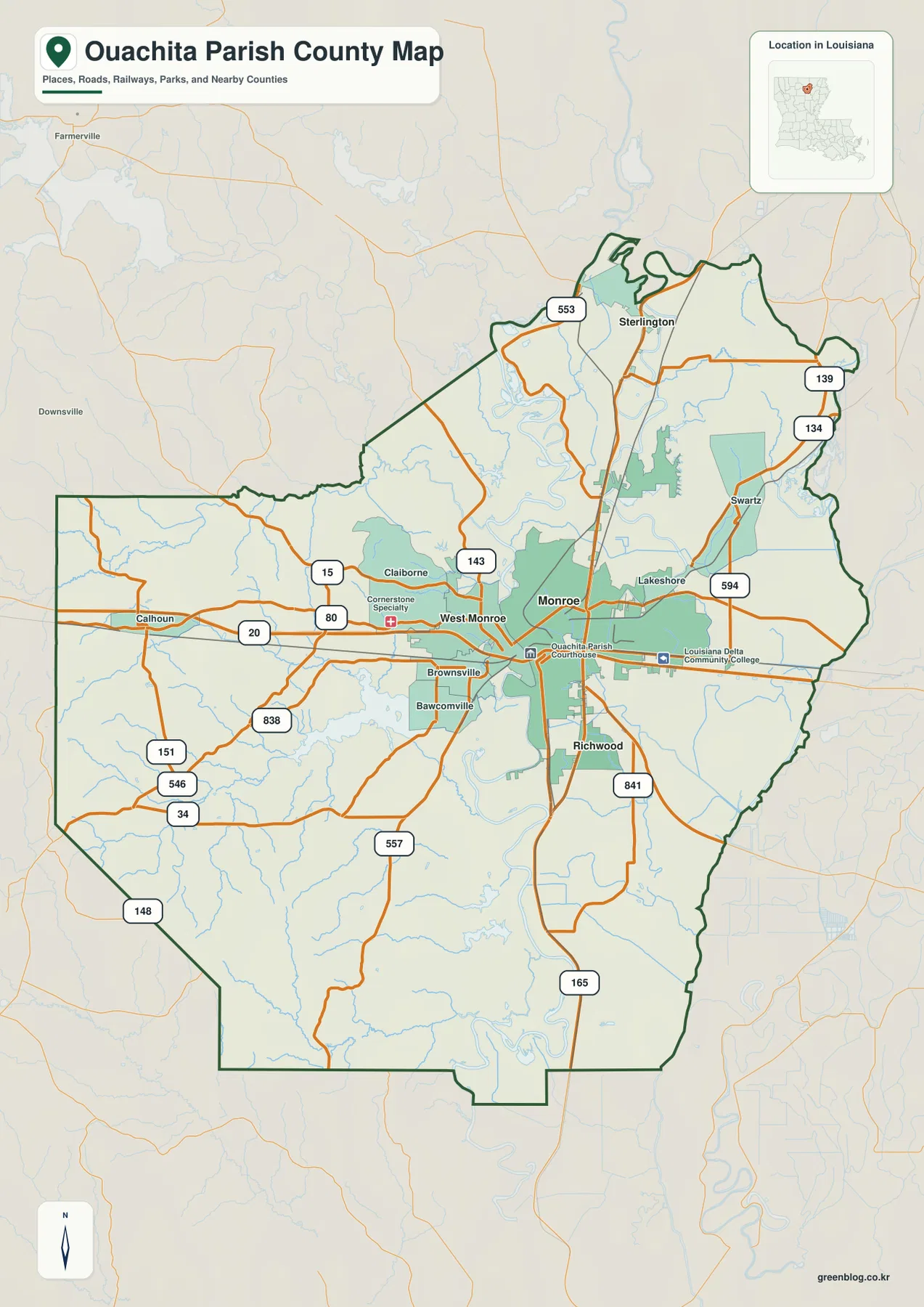
The general map shows Monroe and West Monroe as the dominant built-up area in the center of Ouachita Parish. The Ouachita River runs between them, but I-20 and other crossings connect the two sides so closely that they appear as one continuous metropolitan cluster. Lakeshore lies east of Monroe, while Brownsville and Bawcomville extend the developed pattern west and southwest of West Monroe. This concentration makes the central river crossing the easiest place to begin reading the parish.
I-20 is the clearest east-west transportation reference, entering from the Calhoun side, crossing West Monroe and Monroe, and continuing toward the eastern boundary. U.S. 80 follows the same broad corridor, while LA 15 and LA 143 approach the central area from the northwest. Routes such as LA 34, 151, 546, and 838 serve the southwest, and LA 553 extends north. On the eastern side, LA 139, 134, and 594 help organize the Swartz and Lakeshore area.
Sterlington and Richwood mark the northern and southern extensions of the urban network
Sterlington sits well north of Monroe and provides the clearest community reference for the upper parish. LA 553 reaches toward this area, while the parish boundary becomes more irregular around the Ouachita River and its smaller channels. The landscape between Sterlington and Monroe is less continuously urban than the city core, with waterways and open areas occupying more of the map.
Richwood lies in the opposite direction, south of Monroe near U.S. 165 and LA 841. Brownsville and Bawcomville occupy the western side of the broader urban area, while Claiborne and Calhoun help orient the less densely developed western half of the parish. These locations show that Ouachita Parish is not simply Monroe plus one suburb; the settlement pattern extends in several directions from the central river corridor.
Straight-line distances from Monroe make the city relationships easy to compare
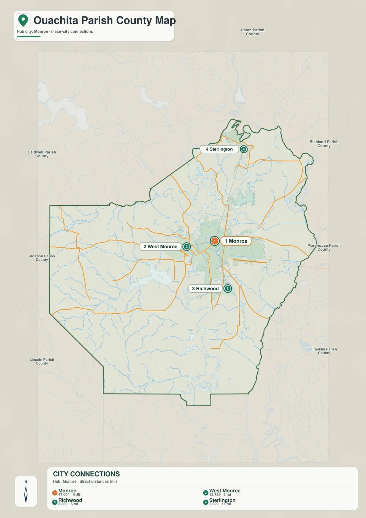
The city-connections map uses Monroe as the hub and compares three nearby communities. West Monroe is shown at about 3 miles, Richwood at about 6 miles, and Sterlington at about 11 miles from the hub. Those figures are direct straight-line distances between the mapped points, not driving mileage along I-20, U.S. 165, or local streets. Actual travel distance can be longer because of river crossings and the road network.
The directions are just as useful as the numbers. West Monroe is immediately west across the Ouachita River, Richwood lies south, and Sterlington is north. This creates a simple three-direction comparison around Monroe and gives a quick sense of the scale of the central settlement network. For a presentation or classroom explanation, the connections view is easier to read than the full road map when only the relative locations of these communities matter.
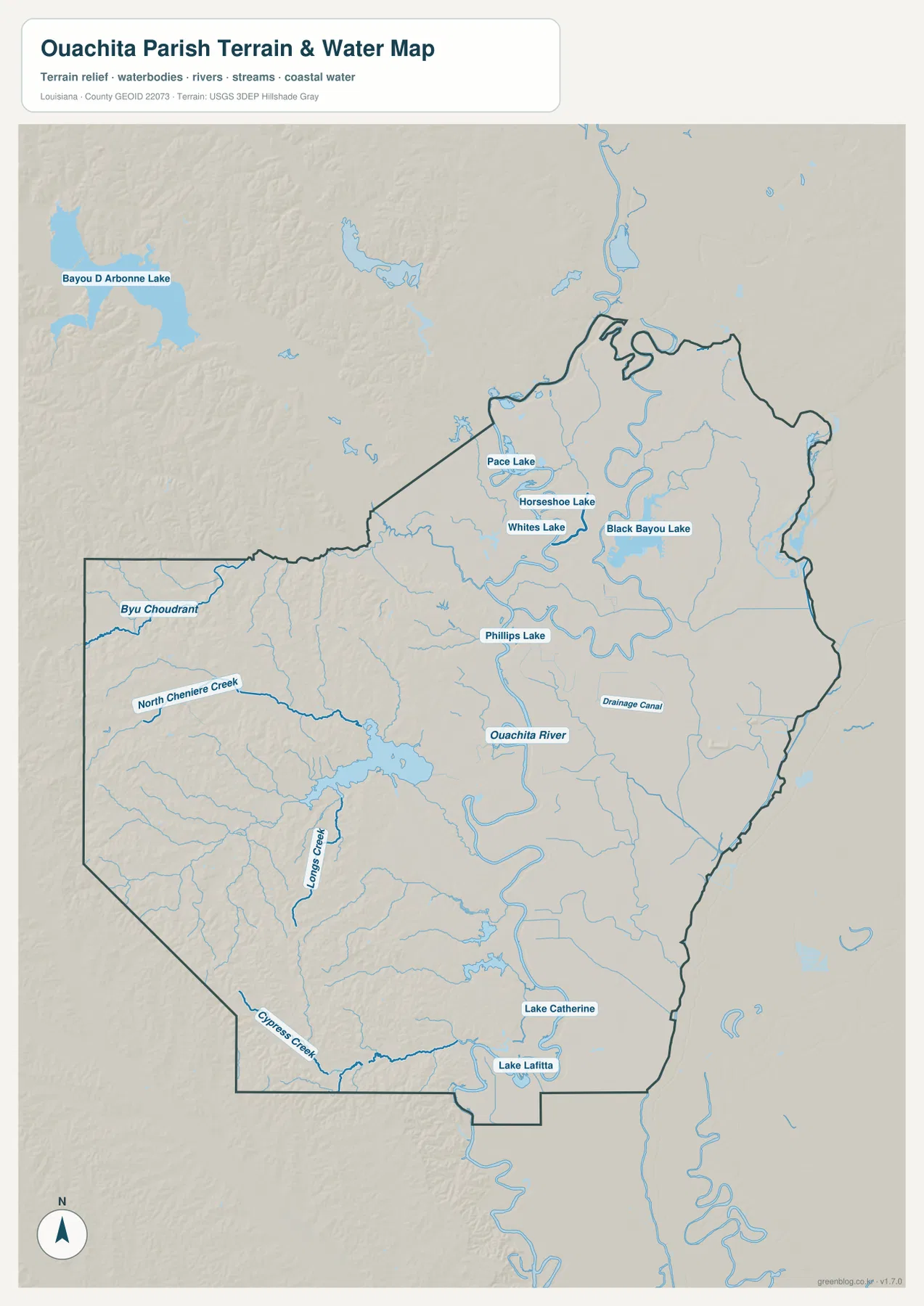
The Ouachita River is the central water feature from north to south
The terrain-and-water map makes the Ouachita River the dominant reference. It enters from the north, passes directly through the Monroe–West Monroe area, and continues south in a series of broad bends. On the road map the river can look like a divider between the two cities; on the water-focused view it becomes a continuous north-south system linking the upper lake country with the tributaries and lowlands farther south.
Several named lakes cluster north and northwest of Monroe. Pace Lake, Horseshoe Lake, and Whites Lake sit relatively close together, while Black Bayou Lake occupies a larger area to the east. Phillips Lake lies nearer the main river. Bayou D’Arbonne Lake is visible beyond the parish boundary to the northwest, making it useful as a regional reference even though the main lake body is outside Ouachita Parish.
Western creeks and southern lakes fill out the drainage beyond the main river
The western half contains several long named streams that are much easier to see on the water map than on the general road view. Bayou Choudrant and North Cheniere Creek cross the western side, and Lazarus Creek forms another strong north-south reference closer to the middle. These channels run through areas with fewer large settlement labels, so the water network becomes the better tool for geographic orientation.
Farther south, Cypress Creek appears near the western boundary, while Lake Catherine and Lake Lafitta are labeled near the lower parish. A Drainage Canal is also marked in the east-central section. These natural and engineered water features are shown for location reference only. The map does not provide flood-zone classifications, water depth, navigability, levee status, or legal property boundaries, so specialized decisions require current official data.
Use I-20 for the urban layout and the Ouachita River for the natural layout
A practical first pass is to follow I-20 from Calhoun through West Monroe and Monroe. From the central city, add Sterlington to the north, Richwood to the south, and Swartz and Lakeshore to the east. Claiborne and Calhoun help with the western side. This method keeps the large number of state-road labels from becoming overwhelming and makes it easier to focus on the section of the parish that matters for a particular question.
For water features, use the Ouachita River as the spine. Black Bayou Lake and the nearby lake cluster organize the north, the Cheniere Creek system helps with the west, and Cypress Creek with Lake Catherine and Lake Lafitta provides southern reference points. The general map is best for roads and settlements, the city-connections graphic for the three nearby communities, and the water map for the river, lakes, creeks, and drainage channels.
High-resolution JPG files preserve the smaller road and water labels
The downloadable ZIP contains the original JPG files corresponding to the three previews on this page: the general parish map, the city-connections map, and the terrain-and-water map. Each original image is 2572 by 3638 pixels, providing more room to inspect route numbers, community names, creek labels, and lake names than the web preview. The files are useful for printing, classroom material, presentation slides, and personal geographic reference.
Choose the general map when the Monroe–West Monroe road network and parish boundary need to appear together. Use the city-connections graphic when the directions and straight-line distances from Monroe to West Monroe, Richwood, and Sterlington are the main subject. The water map is better for the Ouachita River, Black Bayou Lake, western creeks, and southern lakes. These are general reference maps rather than legal boundary, survey, flood-risk, or real-time navigation products.
Frequently Asked Questions
What is the parish seat of Ouachita Parish?
Monroe is the parish seat and the largest urban center shown on the supplied map. West Monroe is immediately across the Ouachita River, and I-20 connects the two sides. Monroe also provides the easiest reference for finding Sterlington to the north and Richwood to the south.
Are the 3-, 6-, and 11-mile labels driving distances?
No. The city-connections map uses straight-line distances from Monroe: about 3 miles to West Monroe, 6 miles to Richwood, and 11 miles to Sterlington. Actual road mileage depends on river crossings, the chosen route, and the exact starting point.
Can the terrain-and-water map be used for flood or navigation decisions?
No. It is a general geographic reference showing the Ouachita River, lakes, creeks, and drainage channels. It does not provide flood-zone ratings, water depth, navigability, levee protection, or legal property boundaries. Those decisions require current specialized information from the responsible agencies.
Map File Information
The ZIP contains the original high-resolution JPG files corresponding to the general parish map, city-connections map, and terrain-and-water map shown on this page.
- Included Files: parish map JPG, city-connections map JPG, terrain-and-water map JPG
Related Maps
Sources and references
For local government information, see the Ouachita Parish Police Jury. Current state-road information is available through the Louisiana DOTD Ouachita Parish page. General boundary data are documented by the U.S. Census Bureau TIGER/Line Shapefiles, and national water-feature data are documented through USGS National Hydrography.
Green Map creates custom-edited map images using open geographic data sources such as geoBoundaries, Natural Earth, OpenStreetMap, and government open data. These maps are edited visual materials, not raw data files, and are provided for education, documents, presentations, and graphic reference.