Lafayette Parish sits in south-central Louisiana, where a compact parish boundary contains a dense cluster of municipalities, roads, coulees, bayous, and the Vermilion River. Lafayette occupies the broad central and eastern urban area, while Carencro lies to the north, Scott and Duson stretch westward, and Broussard and Youngsville form a second concentration toward the southeast. This page separates those features into a general parish map, a ranked city-distribution map, and a terrain-and-water map. High-resolution JPG originals matching all three maps are also available together in the downloadable ZIP.
The parish is easier to understand when Lafayette is used as the reference point rather than treating the boundary as a simple rectangle. Development spreads outward in several directions, yet the western and southwestern portions still contain larger open spaces between roads and communities. Lafayette Consolidated Government identifies six municipalities in the parish—Lafayette, Broussard, Carencro, Duson, Scott, and Youngsville—and those same six places appear on the city map. Comparing their positions with the road and water layers gives a clearer picture of how urban growth and drainage features share the same relatively small area.
Table of Contents
Lafayette anchors a ring of nearby municipalities
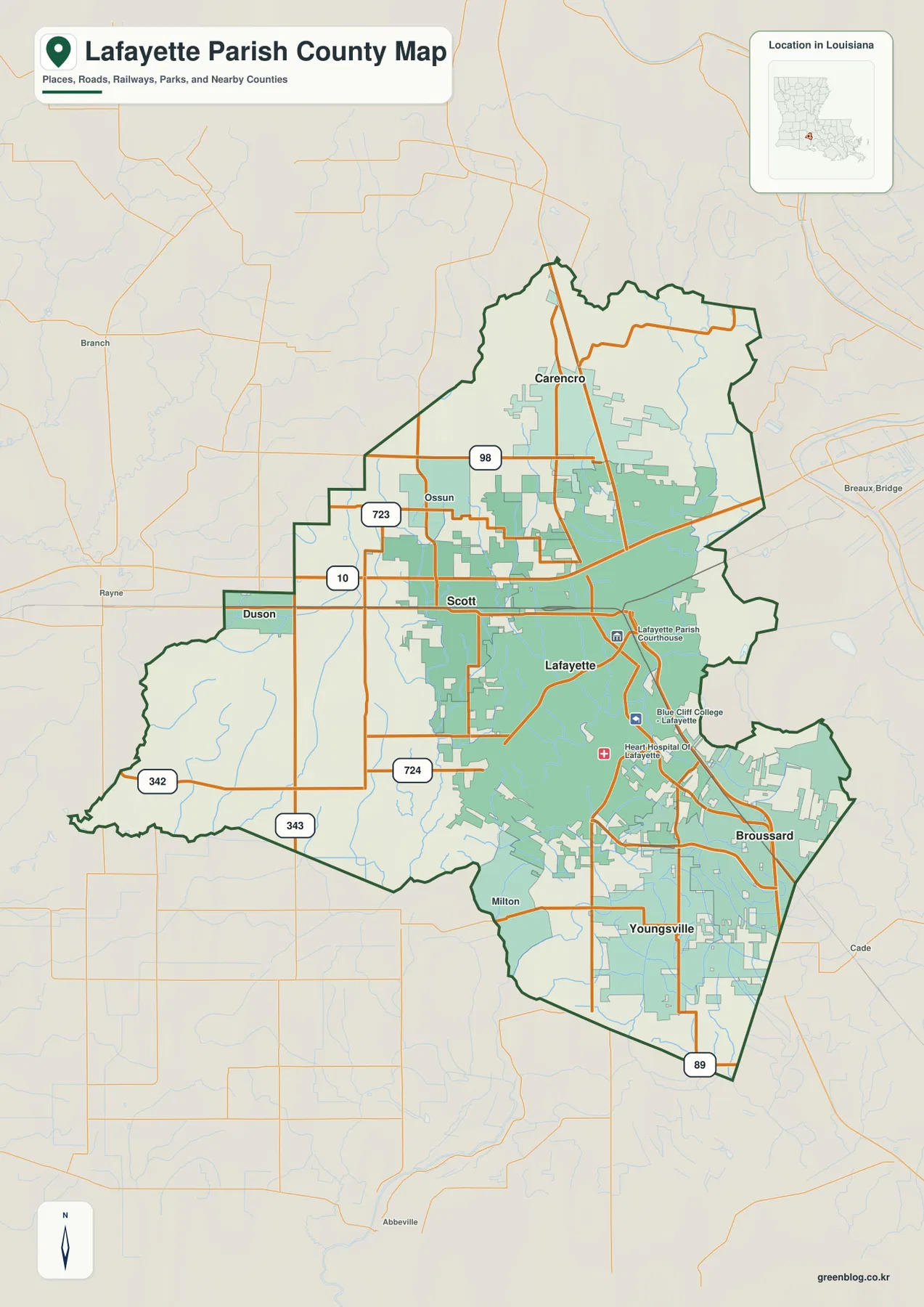
The general map makes Lafayette the most visually prominent settlement. Its developed area covers much of the center and extends eastward, with additional urban patches reaching north toward Carencro and southeast toward Broussard. Scott sits immediately west of Lafayette, while Duson occupies a narrower western extension of the parish. Youngsville is farther south and forms a substantial developed area near the southeastern edge. The result is not a single isolated city surrounded by empty countryside, but a compact network of communities positioned around a dominant urban core.
Several smaller labels help orient the less urban portions of the map. Milton appears southwest of Lafayette, and the western side contains broader gaps between roads than the city center does. Carencro is close to the northern parish line, Broussard lies near the eastern and southeastern side, and Youngsville reaches toward the southern tip. Reading these names before focusing on road numbers makes the parish shape easier to follow because the boundary bends and narrows around different municipal areas rather than following one simple outline.
Roads connect the western edge to the growing southeast
The road pattern is unusually dense for such a compact parish. A major east-west route passes through the Duson and Scott area before crossing the northern side of Lafayette, while north-south roads link Carencro with the urban core. Route markers such as 98, 723, 342, 343, 724, and 89 provide additional reference points around the map. Near Lafayette and Broussard, multiple roads converge in a much tighter pattern than they do in the southwestern part of the parish, reflecting the concentration of development around the central city.
The southwest remains well connected even where the developed footprint is smaller. Routes marked 342 and 343 cross the western and southwestern side, and the road network around Milton and Youngsville forms several north-south and east-west connections. The 89 marker appears near the southern end of the parish, helping locate Youngsville relative to the boundary. These lines are useful for regional orientation, but the map is not a live navigation product. Current construction, travel time, turn restrictions, and exact driving directions should be checked with up-to-date transportation information.
The city index shows six municipalities without implying travel distance
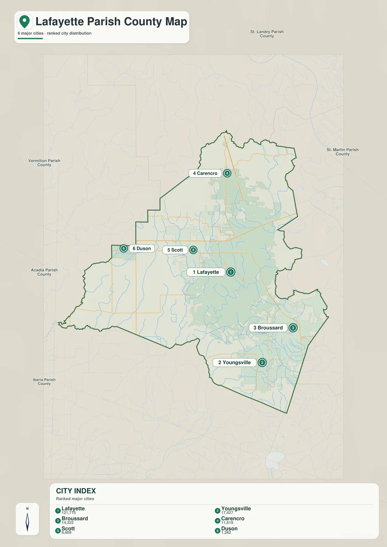
The city-distribution map ranks six major municipalities and places each label directly on the parish outline. Lafayette is number 1, Youngsville number 2, Broussard number 3, Carencro number 4, Scott number 5, and Duson number 6. The CITY INDEX also prints the population figures used when the map was prepared, making Lafayette’s much larger scale immediately apparent. Youngsville and Broussard form a close southeastern pair, Carencro stands apart in the north, and Scott and Duson align west of Lafayette.
This particular city map does not draw connector lines or provide mileage between communities. The numbered circles indicate rank, not driving order or straight-line distance. That distinction matters because Scott is geographically very close to Lafayette even though it carries number 5, and Youngsville and Broussard are adjacent parts of the southeastern urban pattern despite being numbered separately. The map works best as a quick location index; use current Census estimates when a precise contemporary population figure is needed.
The Vermilion River threads through the central and eastern parish
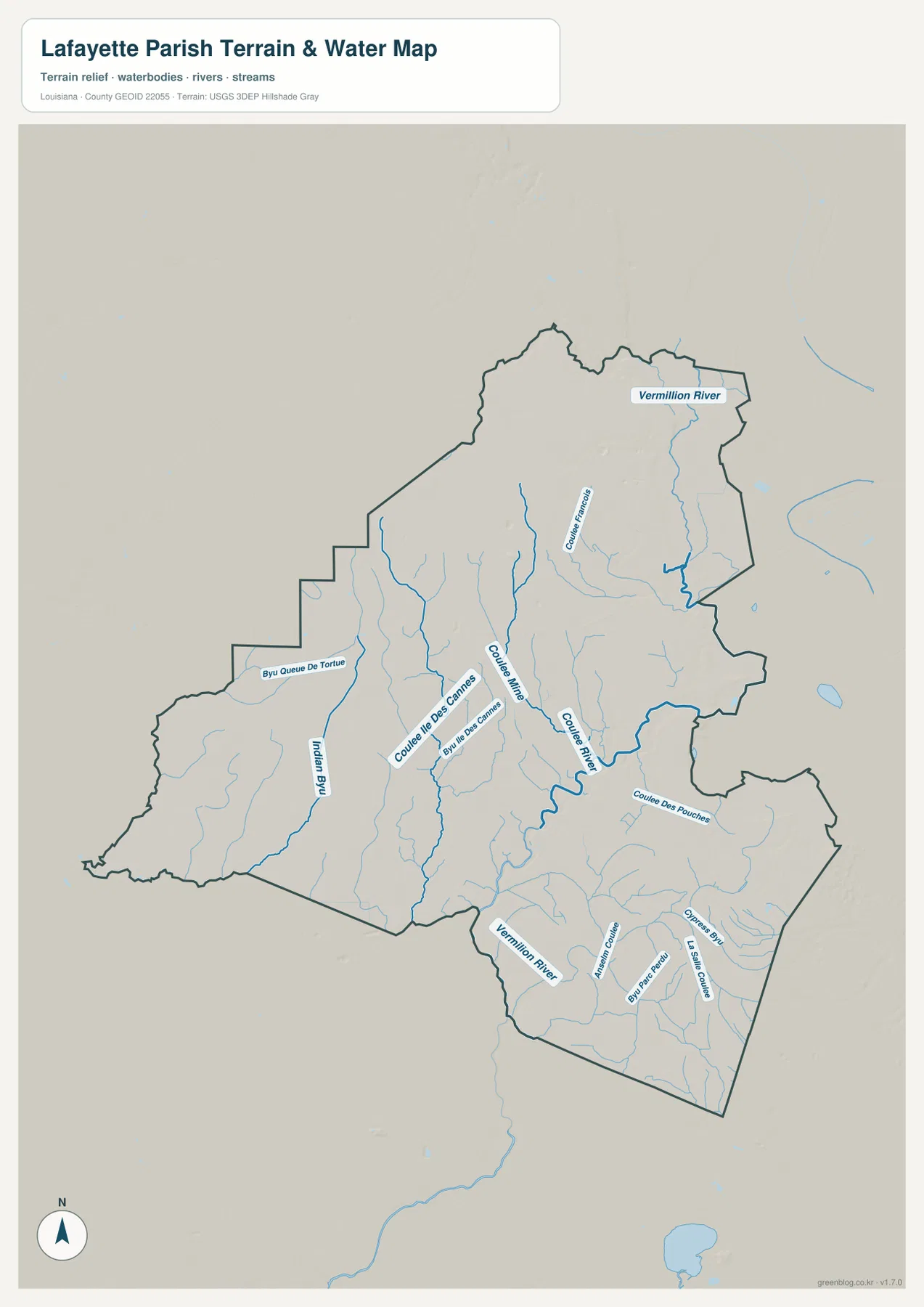
On the terrain-and-water map, the Vermilion River becomes the main organizing feature. It enters the northeastern part of the mapped area, bends through the Lafayette urban region, and continues southward toward the lower parish. The general map emphasizes streets and developed land, so many smaller drainage features are easy to overlook there. The water map removes much of that visual competition and shows how closely the river and its tributary network sit beside the urbanized parts of Lafayette and Broussard.
Lafayette Parish is not dominated by one large lake. Instead, its hydrology appears as a fine network of rivers, bayous, and coulees. Coulee Ile des Cannes is one of the most noticeable named channels in the central area, with smaller branches extending around it. Farther west, Indian Bayou and Bayou Queue de Tortue provide longer reference lines, while Cypress Bayou is labeled in the southeastern drainage network. The many thin blue lines between these named features show why a water-focused map adds information that a road map alone cannot convey.
Western bayous and southeastern coulees create different local patterns
The western side of the parish has a different appearance from the developed center. Bayou Queue de Tortue and Indian Bayou extend through areas with fewer large urban blocks, so their courses stand out clearly against the terrain background. Toward Lafayette, Coulee Ile des Cannes and other smaller channels pass much closer to dense development and roads. That contrast is useful when explaining the parish: the same boundary contains both a highly urbanized center and less developed sectors where watercourses are visually more prominent.
South and southeast of Lafayette, the drainage pattern becomes especially intricate around Youngsville and Broussard. Numerous short channels cross the area before connecting with larger waterways, and some continue beyond the parish boundary. The map is intended for geographic reference rather than flood-zone determination, drainage design, navigation, or property decisions. Anyone evaluating a specific parcel or infrastructure project should consult current Lafayette Consolidated Government GIS information and the appropriate state or federal technical data.
Urban development and drainage features occupy the same compact landscape
Viewing the three maps together reveals why Lafayette Parish can feel more complex than its size suggests. Lafayette, Scott, Carencro, Broussard, and Youngsville are separated by relatively short distances, and developed areas often approach one another closely. At the same time, the Vermilion River, coulees, and bayous continue through or beside those urban areas. The parish therefore does not divide neatly into a city half and a rural half; roads, municipalities, open land, and drainage features overlap throughout much of the map.
One useful comparison is the corridor between Lafayette and Broussard. The general map shows dense development and intersecting roads, while the water map brings forward the channels running through the same part of the parish. West of Lafayette, Scott and Duson are easy to place using the road layer, but Bayou Queue de Tortue and Indian Bayou become more noticeable when the terrain-and-water version is used. Switching between the maps keeps any one layer from obscuring the others.
Choose the map that matches the question you are trying to answer
The general parish map is the best starting point for roads, municipal locations, and the overall boundary. The city-distribution map is cleaner when the goal is simply to compare Lafayette, Youngsville, Broussard, Carencro, Scott, and Duson without the distraction of every road. For the Vermilion River, Coulee Ile des Cannes, Indian Bayou, Bayou Queue de Tortue, and smaller drainage channels, the terrain-and-water map provides the clearest view. Classroom projects, presentations, trip planning, and local-reference work may each benefit from a different version.
The downloadable archive contains the original JPG files corresponding to all three previews on this page. Each image is 2572 × 3638 pixels, providing more room to inspect small labels and road numbers than the web-sized previews. The files are suitable for personal printing, educational material, presentations, and general geographic reference. They should not replace current official records for surveying, legal boundary decisions, live traffic, flood determinations, engineering design, or navigational use.
Frequently Asked Questions
Which municipalities are shown on the Lafayette Parish city map?
The map shows Lafayette, Broussard, Carencro, Duson, Scott, and Youngsville. Lafayette Consolidated Government also identifies these six places as the municipalities within Lafayette Parish. Lafayette occupies the central position, Carencro is north, Scott and Duson are west, and Broussard and Youngsville are southeast of the main city.
Do the numbers 1 through 6 represent distance from Lafayette?
No. The numbers are a ranked city index, not mileage or travel sequence. The labels are intended to distinguish the six municipalities and show their relative locations. Use a current routing service for driving distance and current Census data when an up-to-date population estimate is required.
Which map is best for the Vermilion River and the parish’s smaller waterways?
The terrain-and-water map is the clearest choice. It emphasizes the Vermilion River along with Coulee Ile des Cannes, Indian Bayou, Bayou Queue de Tortue, Cypress Bayou, and many smaller channels. It is a general geographic reference and should not be used to determine flood zones, channel depth, drainage capacity, legal water boundaries, or navigation conditions.
Map File Information
The ZIP contains the original high-resolution JPG files corresponding to the general parish map, ranked city-distribution map, and terrain-and-water map shown above.
- Included Files: parish map JPG, city-distribution map JPG, terrain-and-water map JPG
Related Maps
Sources and references
- Lafayette Consolidated Government — Municipalities — Official overview of the six municipalities that make up Lafayette Parish.
- Lafayette Consolidated Government — Maps and GIS — Official local GIS and downloadable-map resources.
- Lafayette Parish Hazard Mitigation Plan — Local government material describing the parish’s geographic setting.
- USGS National Hydrography — Federal reference for rivers, bayous, channels, and other hydrographic features.
- U.S. Census Bureau TIGER/Line — Official geographic boundary and road data.
Green Map creates custom-edited map images using open geographic data sources such as geoBoundaries, Natural Earth, OpenStreetMap, and government open data. These maps are edited visual materials, not raw data files, and are provided for education, documents, presentations, and graphic reference.