Pulaski County is easiest to understand by starting at Winamac, then following the roads and waterways outward. Winamac sits slightly east of the county’s center, where Route 14 crosses the county from west to east and Routes 35 and 119 provide strong north–south and southwest connections. Francesville and Medaryville lie well to the west, Monterey is northeast of Winamac, and smaller places such as Pulaski and Star City help define the southern half. This Pulaski County Indiana Map set also shows a very different natural pattern: the Tippecanoe River bends through the eastern half while straighter drainage ditches are more common in the west. The WebP images are convenient for on-page viewing, and the original high-resolution JPG map files can be downloaded below for closer inspection or printing.
The four supplied maps are most useful when read as views of the same county rather than as separate illustrations. The general map establishes roads and settlements. The city-connections map simplifies direction and straight-line spacing from Winamac. The terrain-and-water map makes the Tippecanoe River, Mill Creek, Little Mill Creek, Mud Creek, Indiana Creek, and several western ditches much easier to trace. Finally, the elevation map shows why the river corridor looks different from the eastern edge: lower green terrain follows much of the river valley, while tan and brown high ground becomes more prominent farther east and northeast.
That combination gives Pulaski County a clear internal contrast. Its major numbered roads are mostly straight and easy to use as directional guides, but the main river repeatedly curves across the eastern interior. The elevation surface adds another layer because the river’s winding path corresponds to a lower valley, while the eastern side rises above it. A reader looking only for a town can stay with the general map, while someone interested in waterways or relief can move to the specialized maps without losing the location established around Winamac.
Table of Contents
Winamac at the road crossroads, with Francesville and Medaryville to the west
Winamac is the clearest anchor on the general county map. Route 14 runs east–west through the town, giving the county a strong horizontal reference line. Route 35 extends south from the Winamac area toward Star City, while Route 119 approaches from the southwest near Pulaski. Once those three roads are recognized, the map becomes much easier to scan. Winamac marks the point where the eastern river country, the western settlements, and the southern roads can be compared without having to memorize every local label.
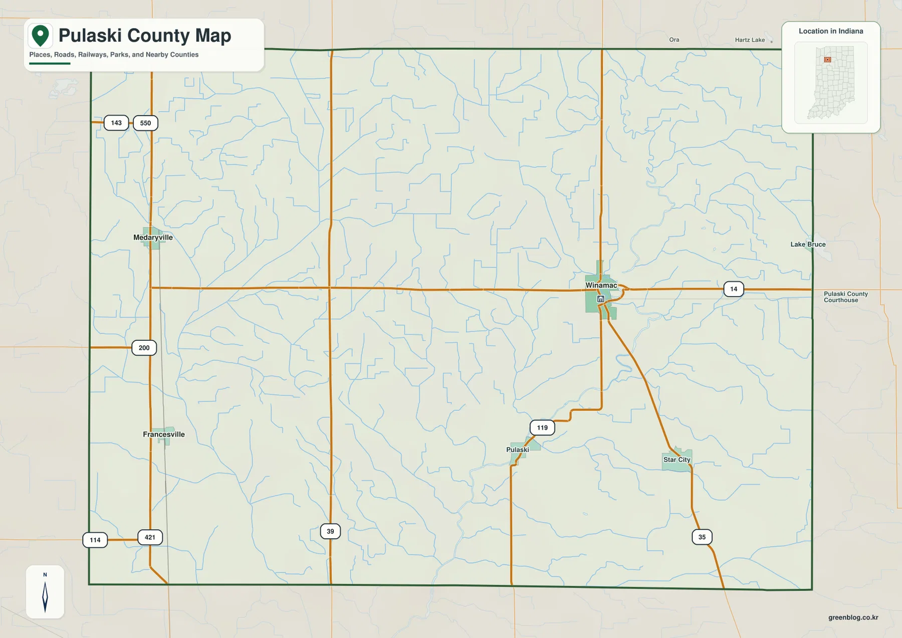
Western Pulaski County has a different arrangement. Route 421 runs near Francesville and Medaryville, with Medaryville in the northwest and Francesville farther south. Route 39 forms another north–south line farther east, between those western places and Winamac. Near the northwest corner, the map also labels Routes 143 and 550, while Route 114 appears near the southwestern edge and meets the 421 corridor. These lines make the west side look more like a grid of long directional routes than the river-shaped eastern interior.
South of Winamac, Pulaski and Star City provide two useful reference points, but they are not on the same road. Pulaski sits closer to the Route 119 approach from the south-central part of the county, while Star City is farther southeast near Route 35. Their positions explain why the two southbound connections from Winamac separate rather than forming one simple corridor. When the map is used for orientation, locating these two places helps distinguish the central-southern route from the route that remains closer to the eastern side.
The general map also shows Lake Bruce just beyond the eastern side of the county and a dense network of small blue waterways inside the boundary. Those features are useful as surrounding context, but this map is primarily a county overview rather than a detailed road-status product. Numbered routes can be used to understand direction and relative placement, while current closures, construction, or travel restrictions should be checked with a current transportation source when they matter.
Comparing Francesville, Medaryville, and Monterey from Winamac
The city-connections map removes much of the secondary road detail and makes the settlement pattern easier to compare. Winamac is the hub. Francesville is shown about 15 miles to the west-southwest, Medaryville about 15 miles to the west-northwest, and Monterey about 9 miles to the northeast. The map specifies that these are direct distances, so they are straight-line measurements, not driving mileage. Road routes may be longer depending on the path taken.
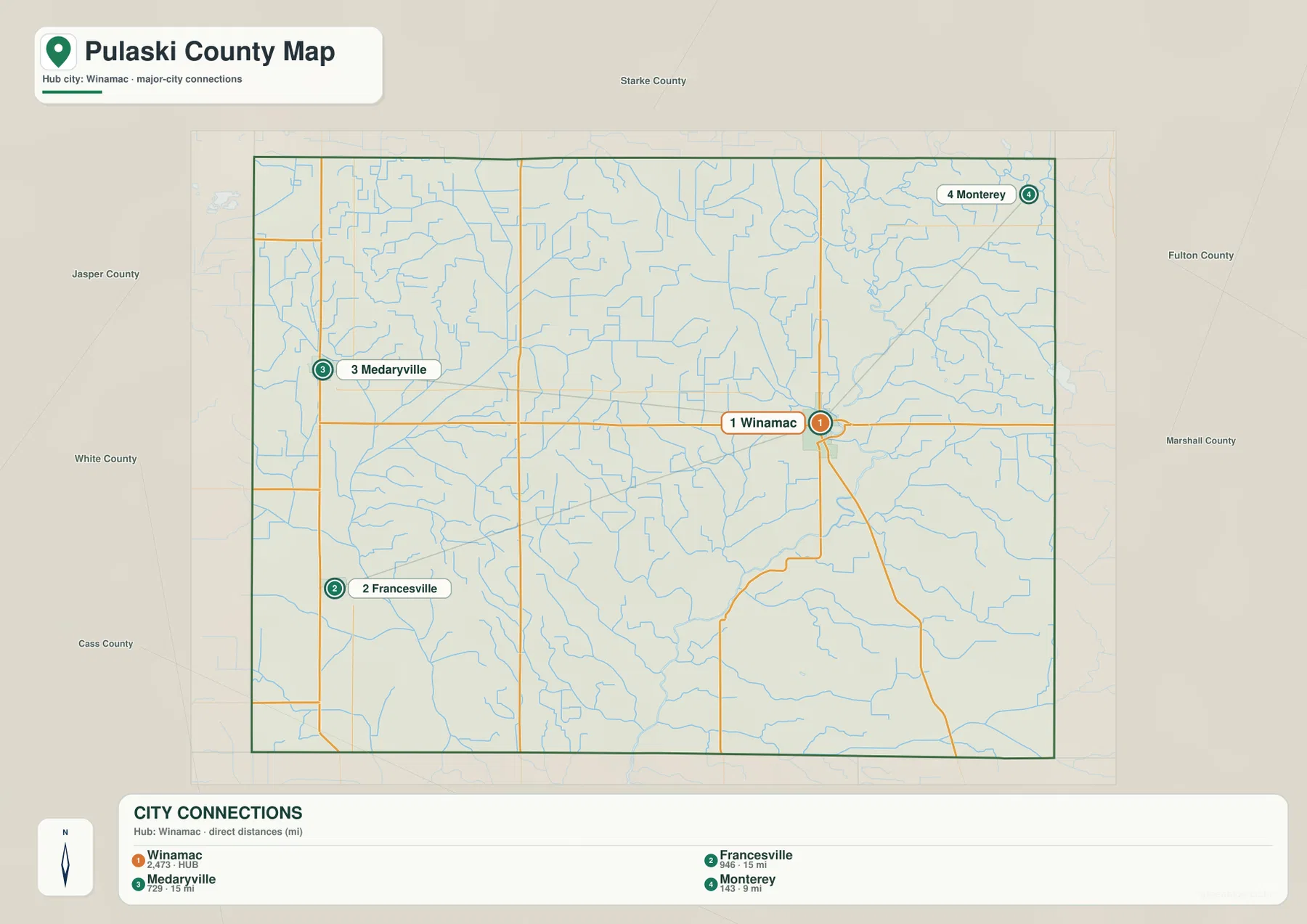
Francesville and Medaryville have similar distance labels, yet their directions are clearly different. Francesville is the southwestern western-side reference, whereas Medaryville is the northwestern one. Monterey is closer to Winamac and lies on the opposite side of the county toward the northeast. This is a useful reminder that a single distance number does not describe the county’s geography by itself; direction matters just as much. The general map can then be used to see which numbered roads occupy the space between those points.
The small numeric values printed next to the city names are best treated as map annotations rather than as a claim about the latest official population. For this article, the more reliable visual message is the settlement arrangement: one central hub, two western places separated north and south, and one northeastern place closer to the hub. That pattern is distinctive enough to make the city-connections map useful even without detailed local roads.
Monterey also provides a convenient transition to the natural geography. It lies in the northeastern direction where the Tippecanoe River and its associated low corridor become prominent on the water and elevation maps. Moving from the city map to the water map therefore preserves a recognizable location: the reader can keep Winamac near the middle, look northeast toward Monterey, and then trace the larger river southward through the eastern half of the county.
The winding Tippecanoe River and the straighter drainage ditches of the west
The terrain-and-water map is dominated by the Tippecanoe River. It enters from the north and bends repeatedly through the eastern half before continuing toward the southern boundary. The river’s shape is noticeably different from the road grid: instead of holding a single direction, it swings back and forth through broad curves. Several smaller waterways approach it from the east and southeast, including Little Mill Creek, Mill Creek, Mud Creek, and Indiana Creek. These labels make the specialized water map much more useful than the general map when the question is the name and position of a stream.
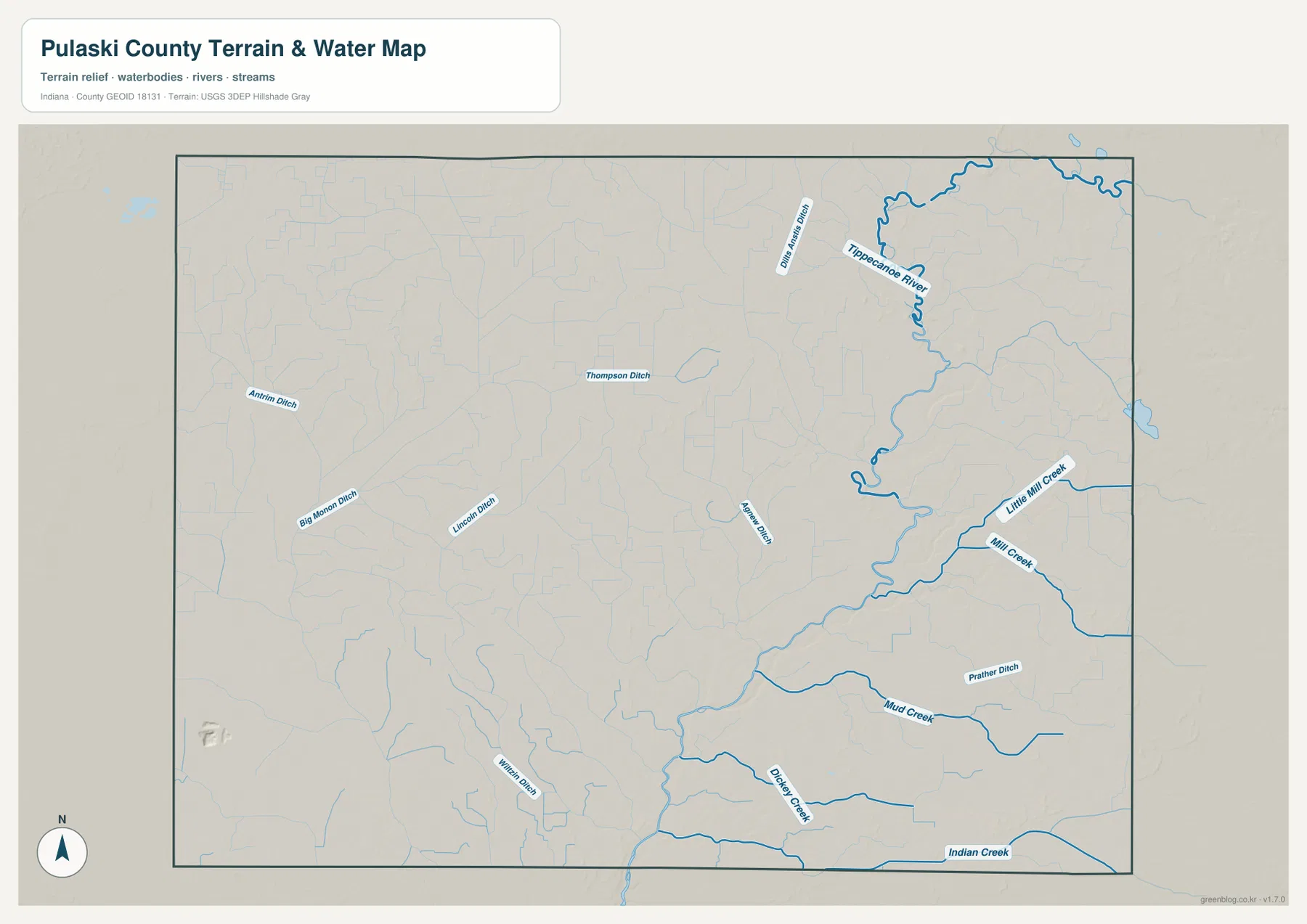
Western Pulaski County has a different visual character. Big Monon Ditch, Lincoln Ditch, and Thompson Ditch are labeled across the west and central-west, and their lines are generally straighter than the main river. Some turn at sharp angles or follow long direct segments. Seeing these features beside the Tippecanoe River helps explain why the county’s blue linework changes from one side to the other. The east is organized around a large natural river and branching creeks, while the west contains many narrower drainage channels with a more rectilinear appearance.
Along the eastern side, Little Mill Creek and Mill Creek approach the Tippecanoe River from higher ground. Farther south, Mud Creek and Indiana Creek add more branches to the network. The main river never becomes a simple north–south line; its repeated bends shift the low corridor east and west across the county. That movement matters when the water map is compared with the elevation map, because the lower green colors follow the same meandering route rather than forming one straight strip.
This map should be used as a county-scale water reference, not as a flood map, parcel map, legal water-boundary product, drainage-engineering plan, or navigation chart. It is well suited to questions such as where the Tippecanoe River crosses the county, which creeks lie on its eastern side, and how the western ditches differ in shape from the main river. Decisions involving current flood conditions, legal jurisdiction, or site-specific drainage require the appropriate current agency data.
A 97–238 meter landscape with a low river valley and higher eastern ground
The elevation legend reports an actual county range of about 97 to 238 meters and a mean of 213 meters. Green colors represent lower areas within the county-scale display, while tan and brown represent higher ground. The strongest feature is the low corridor that follows the Tippecanoe River. Beginning near the northeastern part of the county, the green valley bends southward in almost the same shape as the river shown on the water map. This correspondence makes the two maps especially useful as a pair.
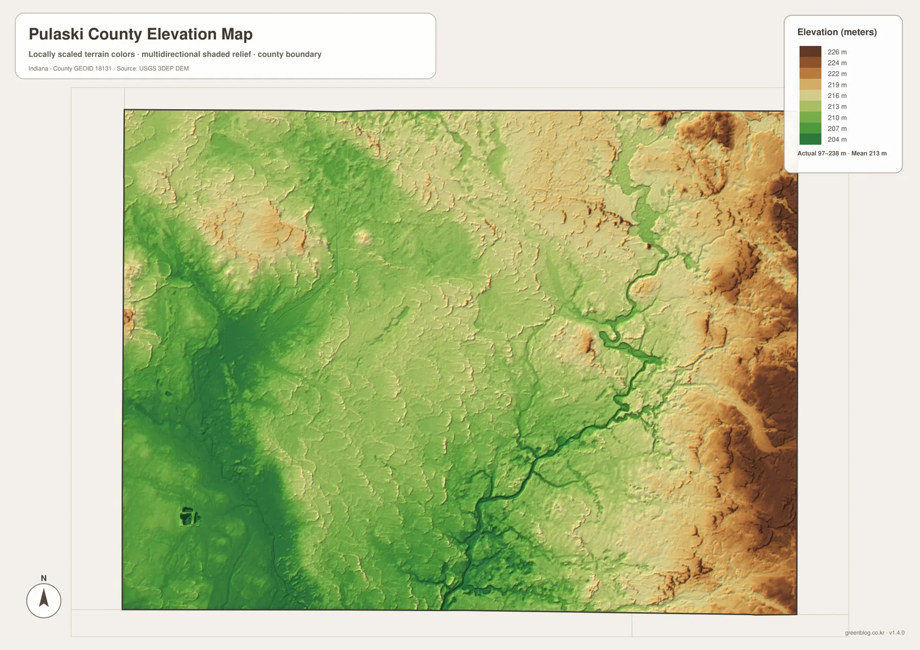
Higher ground is most conspicuous toward the eastern and northeastern edge, where brown and tan shading becomes more frequent. The contrast is sharp in places because the higher terrain stands close to the lower river corridor. Looking at Little Mill Creek and Mill Creek on the water map, then finding the same general area on the elevation map, shows smaller valleys descending from the higher side toward the Tippecanoe. This is a clearer explanation of the terrain than simply saying that the east is “higher,” because the river valley interrupts that high ground with a narrow low route.
The western and southwestern portions contain broad areas of green shading and generally look lower and smoother than the eastern edge. They are not perfectly flat; subtle ridges and shallow depressions remain visible in the shaded relief. Compared with the east, however, the west lacks the same strong combination of a deeply traced meandering river corridor beside immediately higher ground. This difference helps distinguish the Francesville–Medaryville side from the Tippecanoe River side even before settlement names are added.
The elevation surface is generalized for county-level viewing. It is useful for understanding relative highs and lows, the position of a river valley, and broad terrain differences, but it is not a survey-grade surface and should not be used to determine a precise building elevation, road grade, or engineering design value. When exact elevations matter, the USGS 3D Elevation Program or a professional survey source is more appropriate.
Choosing between the road, city, water, and elevation views
Use the general county map when the priority is a place name, a numbered road, or the overall county outline. It gives the most complete single view of Winamac, Francesville, Medaryville, Pulaski, Star City, and the major route labels. The city-connections map is better when road detail is unnecessary and the question is simply how Francesville, Medaryville, and Monterey are positioned relative to Winamac. Because its distance labels are straight-line measurements, it works best for orientation rather than trip mileage.
Choose the terrain-and-water map for stream names and river tracing. It separates the Tippecanoe River, Mill Creek, Little Mill Creek, Mud Creek, Indiana Creek, and several western ditches more clearly than the general map. Then use the elevation map when the question changes from “where is the water?” to “what kind of ground surrounds it?” The low river corridor, broad western low areas, and higher eastern edge can be compared without the distraction of road labels.
The WebP previews are sized for comfortable browser viewing. For larger road labels, smaller water names, elevation colors, or print output, the downloadable archive contains the original high-resolution JPG versions of the general county map, city-connections map, terrain-and-water map, and elevation map. Each JPG measures 3638 by 2572 pixels. Using the originals preserves more detail than taking a screenshot of the on-page images.
A practical way to compare the maps is to keep one familiar point in view. Start with Winamac on the general map, note the western and northeastern settlement directions on the city map, trace the Tippecanoe River near the same central-eastern area, and then look for the low green valley on the elevation map. Repeating one location across all four views makes their different purposes clear without turning the page into a list of map types.
Frequently Asked Questions
What is the easiest place to use as a starting point on the Pulaski County maps?
Winamac is the most useful starting point. It sits slightly east of the county center, Route 14 crosses through it, and Routes 35 and 119 connect nearby. From Winamac, Francesville and Medaryville are to the west, Monterey is northeast, and Pulaski and Star City help orient the southern half.
Are the 15-mile distances to Francesville and Medaryville driving distances?
No. The city-connections map uses direct straight-line distances. Francesville and Medaryville are each shown about 15 miles from Winamac, while Monterey is shown about 9 miles away. Actual road mileage can be longer because the available routes do not follow a straight line.
What does the elevation map add to the Tippecanoe River map?
The water map identifies the river and its tributaries, while the elevation map shows that a lower green valley follows much of the same winding route. Higher tan and brown terrain appears more often to the east and northeast. The elevation legend reports an actual range of about 97–238 meters and a mean of 213 meters.
Map File Information
This ZIP contains the high-resolution JPG originals for the Pulaski County general map, city-connections map, terrain-and-water map, and elevation map. Use the originals for larger road labels, smaller stream names, terrain colors, or print output.
- Printable Size: 3638×2572 px each
Related Maps
Sources and References
The county-specific descriptions above are based on the supplied Pulaski County maps and asset information. The official links below are useful when current boundary, hydrography, or source elevation data is required.
- U.S. Census Bureau TIGER/Line Shapefiles – reference data for county boundaries, roads, and places
- USGS National Hydrography – official hydrography information for rivers and streams
- USGS 3D Elevation Program – source elevation data and program information
Green Map creates custom-edited map images using open geographic data sources such as geoBoundaries, Natural Earth, OpenStreetMap, and government open data.
These maps are edited visual materials, not raw data files, and are provided for education, documents, presentations, and graphic reference.