Evangeline Parish sits in south-central Louisiana, where a chain of small towns and villages is spread across a broad rural road network. Ville Platte is the clearest reference point on the map, while Mamou, Pine Prairie, Turkey Creek, Chataignier, and Basile mark different parts of the parish. The maps on this page separate roads and boundaries from settlement distribution and waterways, and the matching high-resolution JPG files can be downloaded together as a ZIP near the end of the article. High-resolution map files are available for download in the section below.
A useful way to orient yourself is to start with Ville Platte and U.S. 167. The highway runs north from the Ville Platte area toward Pine Prairie and Turkey Creek, while Mamou and Chataignier sit farther south. Basile appears near the southwestern edge of the parish. That arrangement makes Evangeline Parish easier to understand as a long north-to-south landscape rather than a place dominated by one compact urban area.
Table of Contents
Ville Platte and U.S. 167 provide the easiest starting points
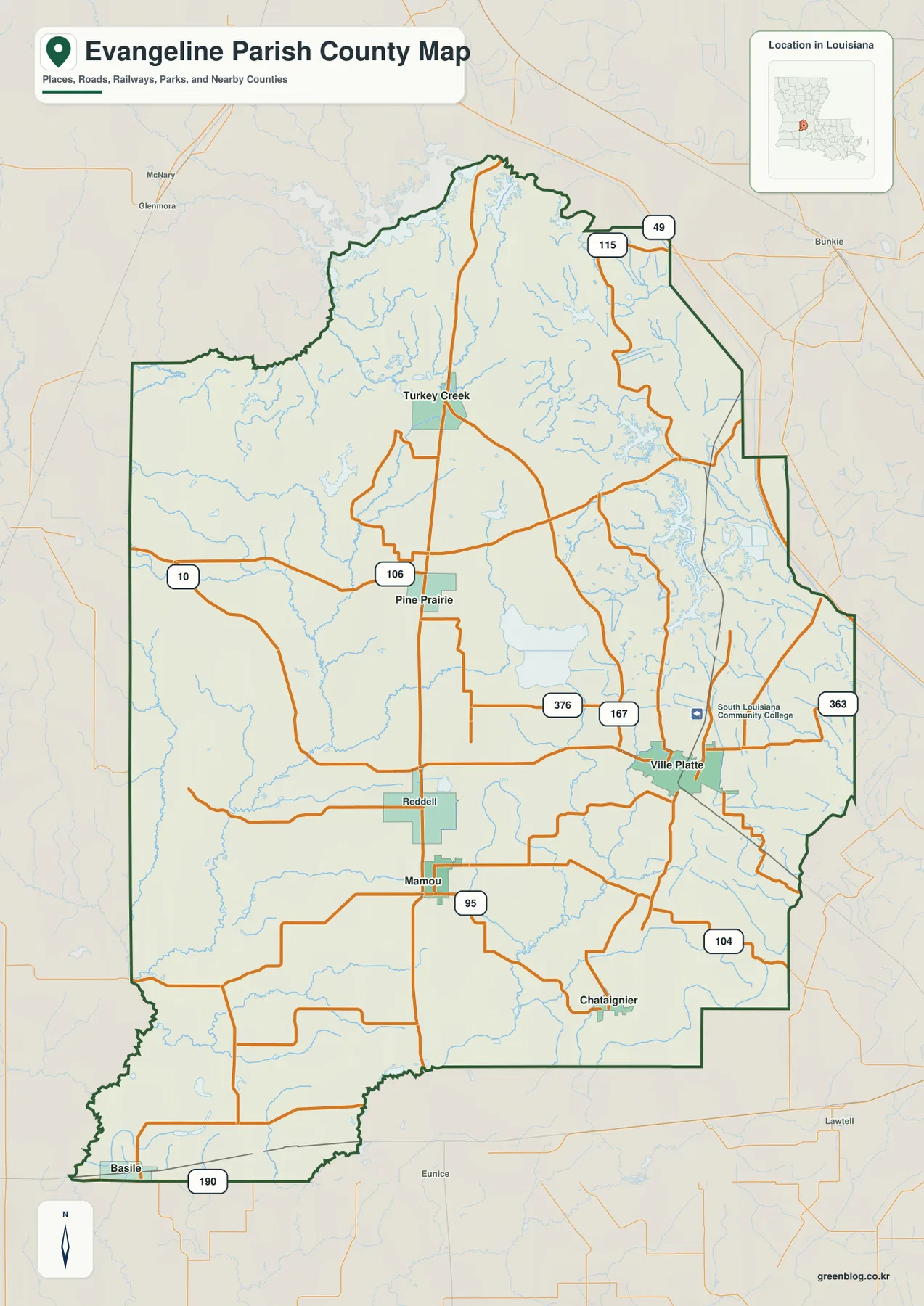
On the general parish map, Ville Platte stands out because several roads meet in and around the city. U.S. 167 passes through the eastern-central part of the parish, connecting the Ville Platte area with Pine Prairie and Turkey Creek to the north. LA 376 approaches from the west, while a web of smaller state and local roads spreads toward Mamou, Chataignier, and the eastern parish line. Following those larger routes first keeps the denser local road pattern from becoming confusing.
The parish outline changes noticeably from one side to another. Parts of the east and south are relatively straight, but the northern and western edges contain more bends. Near the southwest corner, the boundary narrows toward Basile and the U.S. 190 corridor. Places outside the parish, including Bunkie, Eunice, and Lawtell, appear around the frame and help place Evangeline Parish within the wider south-central Louisiana road network.
LA 10, LA 106, and LA 95 divide the parish into useful road references
North of the Ville Platte area, LA 10 and LA 106 help organize the road system around Pine Prairie. LA 10 crosses the western part of the parish and continues through the central-northern road network, while LA 106 meets routes that lead toward Pine Prairie and nearby communities. U.S. 167 remains the strongest north-south reference, but these state routes make it easier to understand how the western side connects with the central corridor.
The southern half has a different road pattern. LA 95 is prominent around the Mamou area, and LA 104 crosses near Chataignier. At the far southwestern edge, U.S. 190 gives Basile a clear regional reference outside the denser Ville Platte road cluster. These lines are useful for geographic orientation, but the map is not a live navigation product. Road closures, construction, and driving times should always be checked with current transportation or navigation information.
East and northeast of Ville Platte, routes such as LA 363, LA 376, LA 115, and LA 49 appear at different points on the map. Rather than trying to memorize every road number at once, it is easier to find Ville Platte, trace U.S. 167 northward, and then work outward to the route needed for a particular town or edge of the parish. This approach also highlights how Pine Prairie and Turkey Creek share a stronger north-south connection, while Mamou and Chataignier depend more on east-west local links.
The settlement map simplifies the parish to six major places
The city-distribution map removes much of the detailed road information and emphasizes six places: Ville Platte, Mamou, Basile, Pine Prairie, Turkey Creek, and Chataignier. Ville Platte is marked as the first-ranked place on this map, with Mamou to the southwest, Pine Prairie and Turkey Creek to the north, Chataignier to the southeast, and Basile at the southwestern edge. The simplified design makes the spacing between communities more obvious than it is on the road-heavy general map.
Neighboring parishes are also labeled around the map. Allen and Acadia parishes lie to the west, Jefferson Davis Parish is toward the southwest, Rapides Parish is north, and St. Landry and Avoyelles parishes appear on the eastern side. Those surrounding labels are especially useful when the goal is to explain regional position rather than individual road names. They should not be treated as a legal boundary survey, but they give quick geographic context.
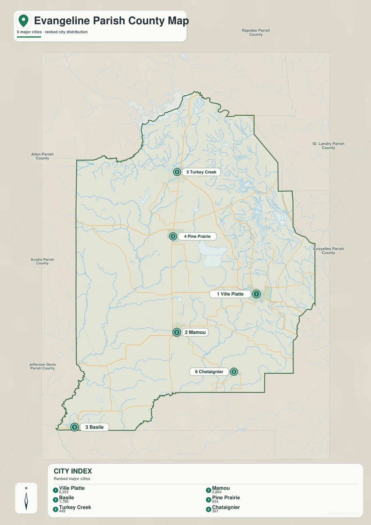
Louisiana State Parks identifies Ville Platte as the parish seat and largest city of Evangeline Parish in its Chicot State Park visitor information. That description matches what the supplied maps suggest visually: Ville Platte is a central reference for roads and nearby communities even though the parish extends far beyond the city. The ranking numbers shown in the city index belong to this map presentation, so readers who need current population estimates should consult current Census data rather than treating the graphic as a live demographic table.
Lake Chicot dominates the eastern water map
The most prominent body of water on the terrain-and-water map is Lake Chicot in the eastern part of the parish. It lies east of the Ville Platte area and is surrounded by numerous small streams and wetland-like channels. Louisiana State Parks describes Chicot State Park, located in Evangeline Parish near Ville Platte, as a landscape of rolling ground and water centered on Lake Chicot. That makes the lake a useful bridge between the road map and the natural-features map: find Ville Platte first, then move east to the large lake system.
Several other named lakes appear north and northwest of Lake Chicot. Dossman Lake and Mountain Bayou Lake are close to the lake-rich eastern section, while Tiger Lake is farther north. Many smaller blue channels are not individually labeled at this scale, but together they show that the eastern side is more water-dense than the road map initially suggests. This is one reason the water map gives a very different impression of the same parish.
Bayou Nezpique branches across the west and center
In the western and central parts of Evangeline Parish, Bayou Nezpique becomes the main water reference. The map labels both West Fork Bayou Nezpique and East Fork Bayou Nezpique, allowing the two branches to be followed separately before they continue southward. Bayou Marsh appears farther west, and smaller tributaries fill the gaps between the named waterways. This branching network contrasts with the broad, easily recognized surface of Lake Chicot on the east.
Farther south, Bayou des Cannes forms another long, curving watercourse, while Bayou Cocodrie is labeled in the northeastern part of the parish. The presence of these named bayous in different directions shows that the parish does not drain toward one single visible channel on the map. For a classroom or regional overview, the water map is therefore more useful than the road map when explaining how streams and bayous are distributed across the parish.
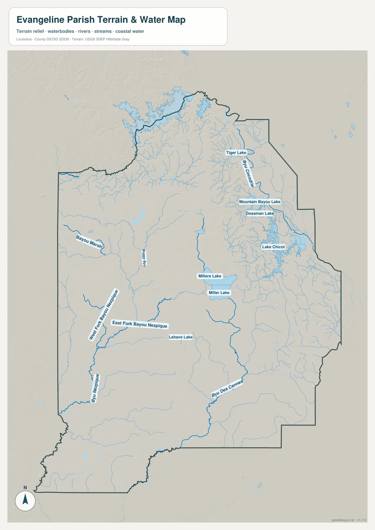
This is a general reference map, not a flood-risk, navigation, parcel, or engineering product. It shows where named water features are located and provides shaded terrain context, but it does not provide water depth, flood frequency, ownership, levee condition, or navigability. The terrain shading is also generalized and should not be used to obtain survey-grade elevations. Official hydrography and elevation sources are more appropriate for technical work.
Pine Prairie and Turkey Creek look simple by road but complex by water
On the general map, Pine Prairie and Turkey Creek are easy to relate because U.S. 167 runs through the same north-south corridor. The water map tells a more complicated story. Numerous small channels spread across the northern half, and the upper parish edge includes broad wet areas and irregular water features. Looking at the two maps side by side helps explain why a region that appears straightforward in terms of highways can still have a dense natural drainage network.
The area east and southeast of Turkey Creek contains many small tributaries, and the lake-rich zone north of Lake Chicot is not far away. Pine Prairie lies closer to the central road network, yet its surroundings also contain numerous streams. For local orientation, this means the road map is best for following community connections, while the water map adds the natural features that are easy to miss when roads are the main visual emphasis.
Mamou, Chataignier, and Basile define three different parts of the south
Mamou occupies a relatively central position in the southern half, with LA 95 providing a clear road reference. Chataignier sits farther east near LA 104, while Basile is separated toward the southwest edge near U.S. 190. The city-distribution map makes these differences especially clear because it removes most minor roads and lets the spacing between the three communities stand out.
The water map adds another layer to the southern half. Bayou des Cannes and waterways associated with Bayou Nezpique continue through this broad area, with many smaller channels between them. A simple road view can make the space between Mamou and Chataignier look relatively open, but the hydrology map shows a much more intricate network of streams. For presentations, showing the settlement map first and the water map second is an effective way to separate human geography from natural features.
Choosing between the general, settlement, and water maps
Use the general parish map when one page needs to show the most information at once. It includes the parish boundary, the major communities, larger road numbers, and enough surrounding context to orient the reader. For a simpler explanation of where people and communities are located, the settlement map is cleaner because it emphasizes Ville Platte, Mamou, Basile, Pine Prairie, Turkey Creek, and Chataignier without the full road detail.
The terrain-and-water map is the better choice when Lake Chicot, Bayou Nezpique, Bayou des Cannes, or smaller streams are the subject. Road labels are de-emphasized so water names and branching channels are easier to see. In a report or slide deck, the general map and water map work well as a pair: one establishes roads and settlements, and the other reveals the natural network beneath that road pattern.
The downloadable ZIP contains the three original JPG files that correspond to the maps shown in the article. Each image is 2572 × 3638 pixels in portrait orientation. The lighter WebP versions are convenient for reading online, while the original JPGs are better suited to printing, classroom handouts, presentation screens, and documents where small road or water labels need to remain legible.
What these maps can and cannot be used for
These maps are intended for general geographic orientation, education, trip preparation, personal research, and presentation material. They are not legal boundary surveys and should not be used to determine property ownership, active road restrictions, flood insurance zones, water depth, navigability, or engineering-grade elevation. For those purposes, readers should consult current official sources such as Census TIGER/Line data, USGS hydrography, transportation agencies, or other appropriate public records.
Within those limits, the three views complement one another well. The general map makes Ville Platte and U.S. 167 easy to locate, the settlement map clarifies the spacing among six major communities, and the water map brings Lake Chicot and the bayou network forward. Together they provide a practical geographic picture without forcing every type of information into a single crowded graphic.
Frequently Asked Questions
What is the easiest place to use as a reference point in Evangeline Parish?
Ville Platte is the most practical starting point. It is the parish seat, several roads meet around it, and U.S. 167 provides a clear north-south reference toward Pine Prairie and Turkey Creek. From Ville Platte, Mamou and Chataignier can then be located farther south while Lake Chicot is easy to find to the east on the water map.
Which map is best for Lake Chicot and Bayou Nezpique?
Use the terrain-and-water map. It shows Lake Chicot along with Dossman Lake, Mountain Bayou Lake, the east and west forks of Bayou Nezpique, Bayou des Cannes, Bayou Cocodrie, and many smaller channels that are less prominent on the general road map.
Are the downloadable files higher resolution than the maps displayed in the article?
Yes. The article uses lighter WebP images for online viewing, while the ZIP contains the matching original JPG files at 2572 × 3638 pixels. The larger originals are more suitable when small labels need to remain readable in print or on a presentation screen.
Map File Information
The ZIP contains the original high-resolution JPG files corresponding to the general parish map, settlement map, and terrain-and-water map shown on this page.
- Included Files: parish map JPG, city map JPG, terrain-and-water map JPG
Related Maps
Sources and references
- Evangeline Parish Police Jury
- Louisiana State Parks – Chicot State Park
- U.S. Census Bureau TIGER/Line Shapefiles
- USGS National Hydrography
Green Map creates custom-edited map images using open geographic data sources such as geoBoundaries, Natural Earth, OpenStreetMap, and government open data. These maps are edited visual materials, not raw data files, and are provided for education, documents, presentations, and graphic reference.