East Carroll Parish occupies a long section of northeastern Louisiana beside the Mississippi River, with Lake Providence serving as the parish seat and the clearest place-name reference on the map. The maps on this page show the parish boundary, local highways, the position of Lake Providence, and a dense network of lakes, bayous, and smaller streams. Matching high-resolution JPG files are available in the download ZIP farther down the page.
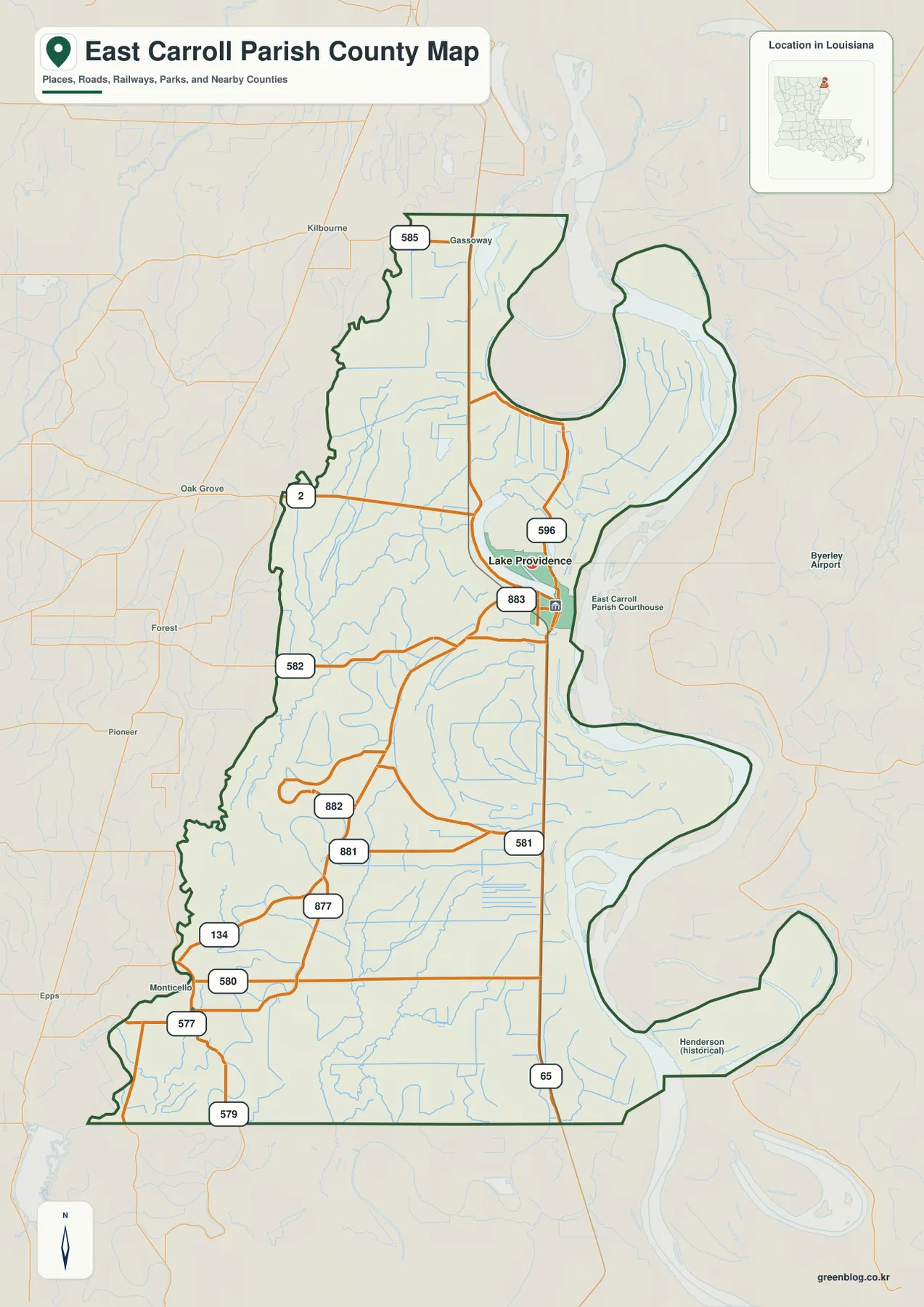
The easiest way to orient yourself is to start with Lake Providence near the eastern side of the parish and then follow the Mississippi River along the irregular boundary. LA 2 approaches the town from the west, while LA 65 runs roughly north to south near the river side of the parish. Away from the town, the map becomes much more rural: numbered state roads spread across broad open areas, and many small waterways weave through the interior before reaching the larger river system.
Table of Contents
Lake Providence as the main reference point
On the general parish map, Lake Providence stands out immediately because the town and the lake sit close together near the Mississippi River. The East Carroll Parish Courthouse is marked nearby, reinforcing the town’s administrative role. Gassoway appears farther north, while places outside the parish such as Kilbourne, Oak Grove, Monticello, and Epps help establish the broader setting. These labels are useful because East Carroll is narrow compared with many inland parishes and stretches much farther north to south than east to west.
The eastern boundary is especially distinctive. Rather than following a straight survey line, it bends repeatedly with the Mississippi River, creating several deep curves and rounded projections. The western edge is straighter overall, though it still contains small irregularities, and the southern boundary includes a long straight segment. Seeing these different boundary types on one map makes it clear how strongly the river has shaped the outline of the parish.
Using LA 2 and LA 65 to understand the road network
Two roads provide the simplest framework for reading the highway map. LA 2 crosses the parish toward Lake Providence from the west, while LA 65 runs along the eastern side and continues south past the town. Once those two routes are located, smaller numbered roads become easier to place. LA 585 and LA 596 lie in the northern half, and LA 581, LA 580, and LA 134 help organize the southern portion of the parish.
The interior network includes routes numbered 881, 882, 877, and 582, along with several short connecting roads. They do not form the dense grid found in an urban parish. Instead, the roads branch across a broad rural landscape and often curve around waterways or property patterns. This map is not intended to replace live navigation or current road-condition information, but it is well suited to understanding which routes lead toward Lake Providence and which roads serve the northern and southern parts of East Carroll Parish.
A city map centered on a single major town
The city-distribution map simplifies the background and emphasizes Lake Providence as the parish’s principal urban reference. Unlike maps of metropolitan parishes that contain several ranked cities, this one highlights a single major town. That makes the geography easy to read: Lake Providence sits well east of the parish’s centerline and close to the Mississippi River side, while large rural areas extend to the west and south.
Neighboring parishes provide additional orientation. West Carroll Parish is shown to the west, Richland Parish to the southwest, Madison Parish to the south, and Morehouse Parish farther north. The map does not try to estimate driving times or road distances between those places. Its value is in showing direction and relative position without the distraction of many road labels, making it useful for classroom materials, presentations, or a quick geographic overview before looking at the more detailed road map.
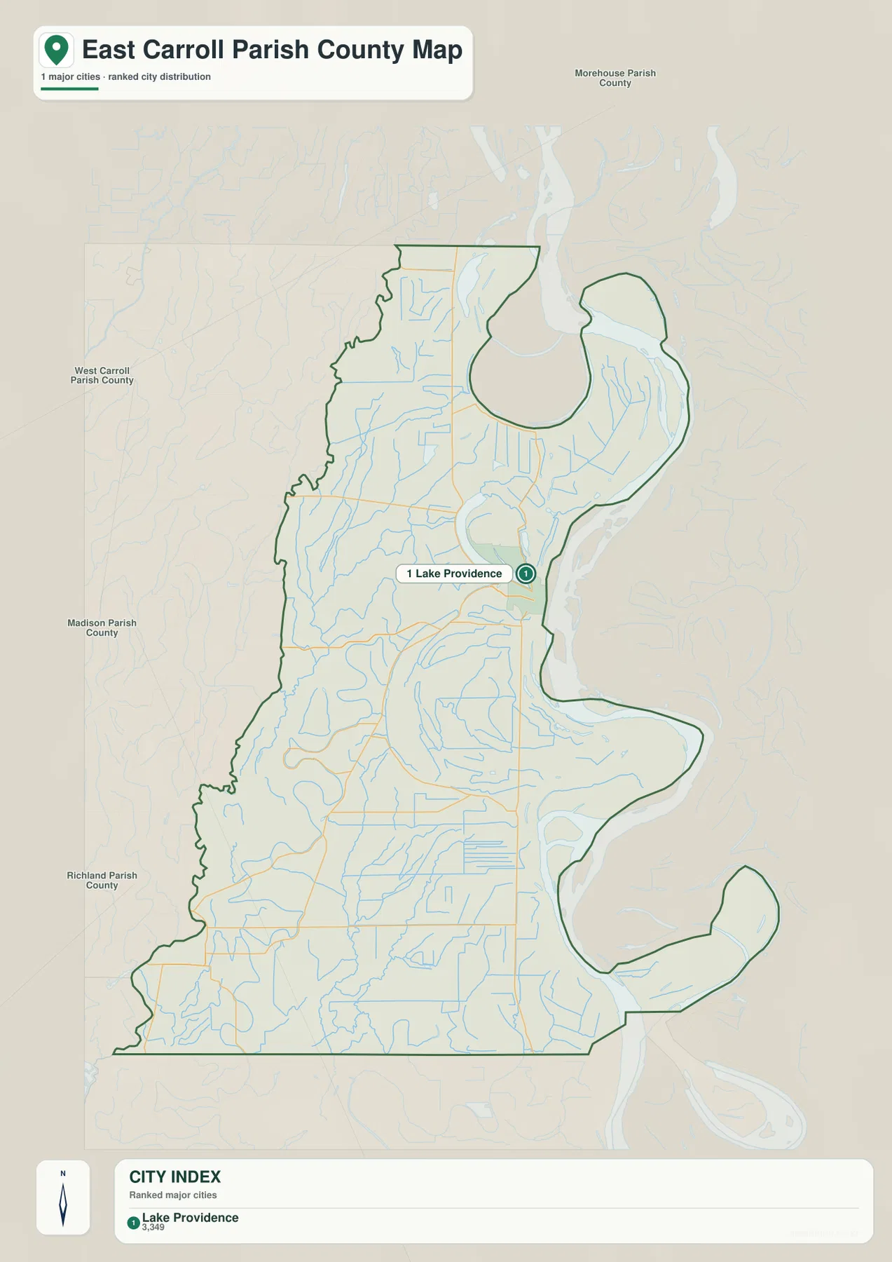
Lake Providence is also a useful bridge between the road and water maps. Find the town on the city map first, then move to the detailed parish map to see LA 2 and LA 65, or switch to the water map to compare the town with its namesake lake and the Mississippi River. Using one familiar point across all three images prevents the smaller roads and waterways from becoming overwhelming.
Mississippi River bends define the eastern edge
The Mississippi River is the strongest geographic feature on the eastern side of East Carroll Parish. It follows nearly the entire edge of the parish and creates large sweeping bends, including a deep curve in the northeast and another broad arc farther south. These bends explain why the parish outline contains rounded lobes instead of a simple straight border. On the general map, the river is part of the regional background; on the water map, its relationship to old channels and nearby lakes becomes much more apparent.
Several named water features sit close to the river. Old River and Old River Chute appear inside the northern bend, while Concord Lake and Vinning Lake lie farther south. Together they illustrate a river landscape where the present channel is not the only prominent water feature. The map should be used for location reference rather than navigation, flood-risk decisions, or levee analysis; those tasks require current information from appropriate state and federal agencies.
Lake Providence and the chain of nearby lakes
Lake Providence is the most useful water landmark because it sits directly beside the town of the same name. North of it, Gassoway Lake and Doe Lake are labeled near the upper part of the parish. Farther south, Concord Lake and Vinning Lake provide additional reference points close to the Mississippi River. The number of named lakes is notable on such a narrow parish map, and they help distinguish the eastern river side from the more creek- and bayou-dominated interior.
Explore Louisiana describes Lake Providence as a northeastern Louisiana community associated with its namesake lake, Mississippi Delta heritage, and the nearby Mississippi River. That regional description matches what the maps show visually: the town, lake, and river are closely related landmarks rather than isolated features. For a visitor or student unfamiliar with the parish, locating these three elements first makes the rest of the map much easier to interpret.
Bayous and creeks spread across the interior
The smaller waterways are just as important for understanding the interior of the parish. Wilson Bayou and Baker Bayou appear in the northern and central portions, while Joe’s Bayou and Tensas Bayou wind through the western and southern half. Graveyard Bayou, Fishers Creek, and Broad Lake are labeled nearer the southern edge. Numerous thinner unnamed channels fill the spaces between them, giving the water map a much denser appearance than the road-focused version.
This network helps explain why a water map adds information that cannot be obtained from the highway map alone. A route that looks isolated on the general map may pass through an area crossed by several bayous and drainage channels. Conversely, the Mississippi River dominates the eastern edge so strongly that the smaller interior watercourses can be easy to overlook. Comparing both versions provides a more balanced picture of how roads and water occupy the same rural landscape.
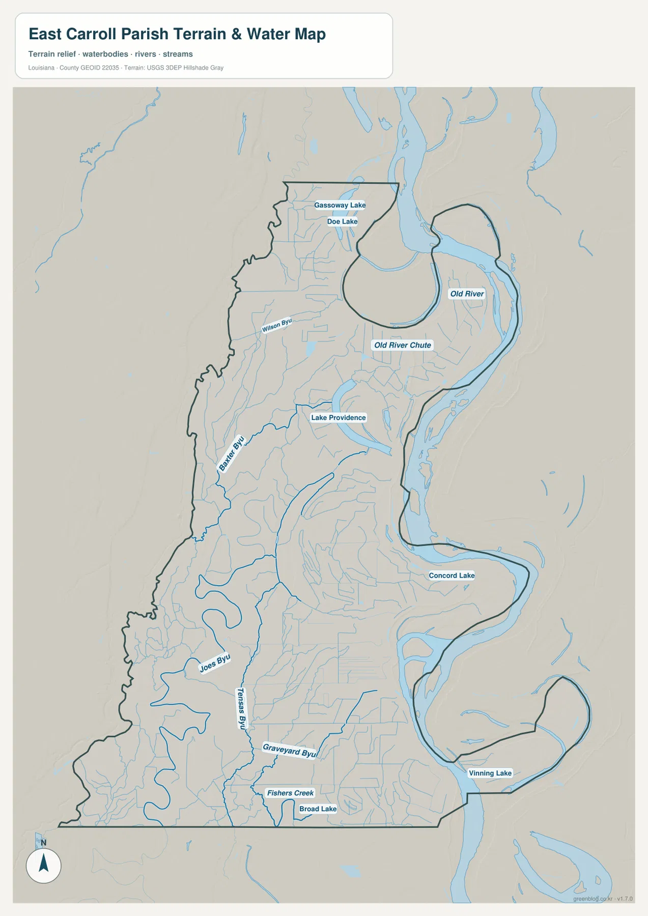
The shaded terrain background is intentionally generalized. It helps separate the broad low-relief surface from the channels and water bodies, but it is not a survey or engineering elevation product. East Carroll Parish is part of the Mississippi Delta region, so the map emphasizes flat river country rather than steep ridges or mountain valleys. Anyone who needs precise elevation values should consult an authoritative elevation dataset such as the USGS 3D Elevation Program.
Reading the road and water maps together
The most useful details emerge when the maps are compared rather than viewed in isolation. On the general map, Lake Providence is a town connected by LA 2 and LA 65. On the water map, the same location becomes the point where a town, an oxbow-shaped lake, and the Mississippi River sit close together. In the south, LA 134 and LA 580 can be located first on the road map and then compared with Joe’s Bayou, Tensas Bayou, Fishers Creek, and nearby water features.
The same method works in the north. Locate LA 585 and the Gassoway area on the parish map, then switch to the water map to find Gassoway Lake and Doe Lake. This approach is useful for school assignments, regional presentations, family-history research, and general place orientation because it links familiar labels instead of asking the reader to interpret every symbol at once.
Choosing a map for print, class, or presentation use
The general parish map works best when you need one image that combines boundaries, roads, nearby places, and major water features. The city map is cleaner and better for explaining where Lake Providence sits within the parish and how East Carroll relates to neighboring Louisiana parishes. The terrain-and-water map is the strongest choice when the subject is the Mississippi River, lakes, bayous, or the physical setting of the Delta.
The download archive contains three original JPG files matching the maps shown in the article. Each image is 2572 × 3638 pixels in portrait orientation, giving you more resolution than the lighter WebP versions used on the page. That makes the JPG files better suited to printing, full-screen slides, and documents where road labels or smaller water names need to remain readable.
For small-format printing, avoid squeezing every label into a narrow space. If the goal is only to show parish location, the city map may be the clearest option. If readers need minor water names, use the water map at a larger size. Matching the map to the purpose usually produces a cleaner result than placing all available detail into a single figure.
Important limits of these reference maps
These maps are designed for general geographic reference, learning, trip preparation, presentations, and personal map collections. They are not legal boundary surveys, parcel maps, flood-insurance maps, live road-condition products, navigation charts, or engineering elevation models. For official boundary and road data, consult sources such as the U.S. Census Bureau TIGER/Line files; for hydrography, use the USGS National Hydrography resources and other current agency data.
Within those limits, the set is a practical way to understand East Carroll Parish quickly. Lake Providence provides a consistent central landmark, LA 2 and LA 65 organize the road network, the Mississippi River explains the unusual eastern boundary, and the water map reveals the many bayous and lakes that are easy to miss on a road-focused image. Together, those elements give a clear introduction to this part of northeastern Louisiana without requiring specialized GIS software.
Frequently Asked Questions
Which map is best for finding Lake Providence quickly?
The city-distribution map is the simplest choice because it emphasizes Lake Providence without many competing road labels. It also shows the general direction of West Carroll, Richland, Madison, and Morehouse parishes. Use the general parish map as a second step if you also need LA 2, LA 65, and other numbered roads.
Can I see the Mississippi River, Old River, and Lake Providence on the same map?
Yes. The terrain-and-water map shows the Mississippi River along the eastern edge, Old River and Old River Chute in the northern bend, and Lake Providence beside the town. Concord Lake, Vinning Lake, several bayous, and smaller creeks are also labeled on that map.
What files are included in the download ZIP?
The ZIP contains three high-resolution JPG files corresponding to the general parish map, the city-distribution map, and the terrain-and-water map. Each image is 2572 × 3638 pixels and can be used separately in print documents, presentations, or classroom materials.
Map File Information
Download the original high-resolution JPG files for the general parish map, city-distribution map, and terrain-and-water map in one ZIP archive.
- Included Files: parish map JPG, city map JPG, terrain and water map JPG
Related Maps
Sources and References
- Explore Louisiana – Lake Providence
- U.S. Census Bureau QuickFacts – East Carroll Parish
- U.S. Census Bureau TIGER/Line Shapefiles
- USGS National Hydrography
- USGS 3D Elevation Program
Green Map creates custom-edited map images using open geographic data sources such as geoBoundaries, Natural Earth, OpenStreetMap, and government open data. These maps are edited visual materials, not raw data files, and are provided for education, documents, presentations, and graphic reference.