Beauregard Parish occupies a broad part of southwestern Louisiana, with DeRidder as the main civic and road center, Merryville near the western side, and smaller communities such as Singer, Longville, and Oretta spread across the interior. This Beauregard Parish Map collection shows US 190, US 171, LA 27, LA 110, the Sabine River boundary, Bundick Creek, Bundick Lake, Whiskey Chitto Creek, and many smaller waterways.
The package includes three map themes only: a general parish map, a city-distribution map, and a terrain-and-water map. High-resolution JPG versions of all three are available together in a downloadable ZIP. DeRidder and Merryville provide useful settlement anchors, while the Sabine River on the west and Bundick Creek on the east make the parish’s water geography easy to compare.
Table of Contents
DeRidder joins US 190 and US 171 at the center of the main road network
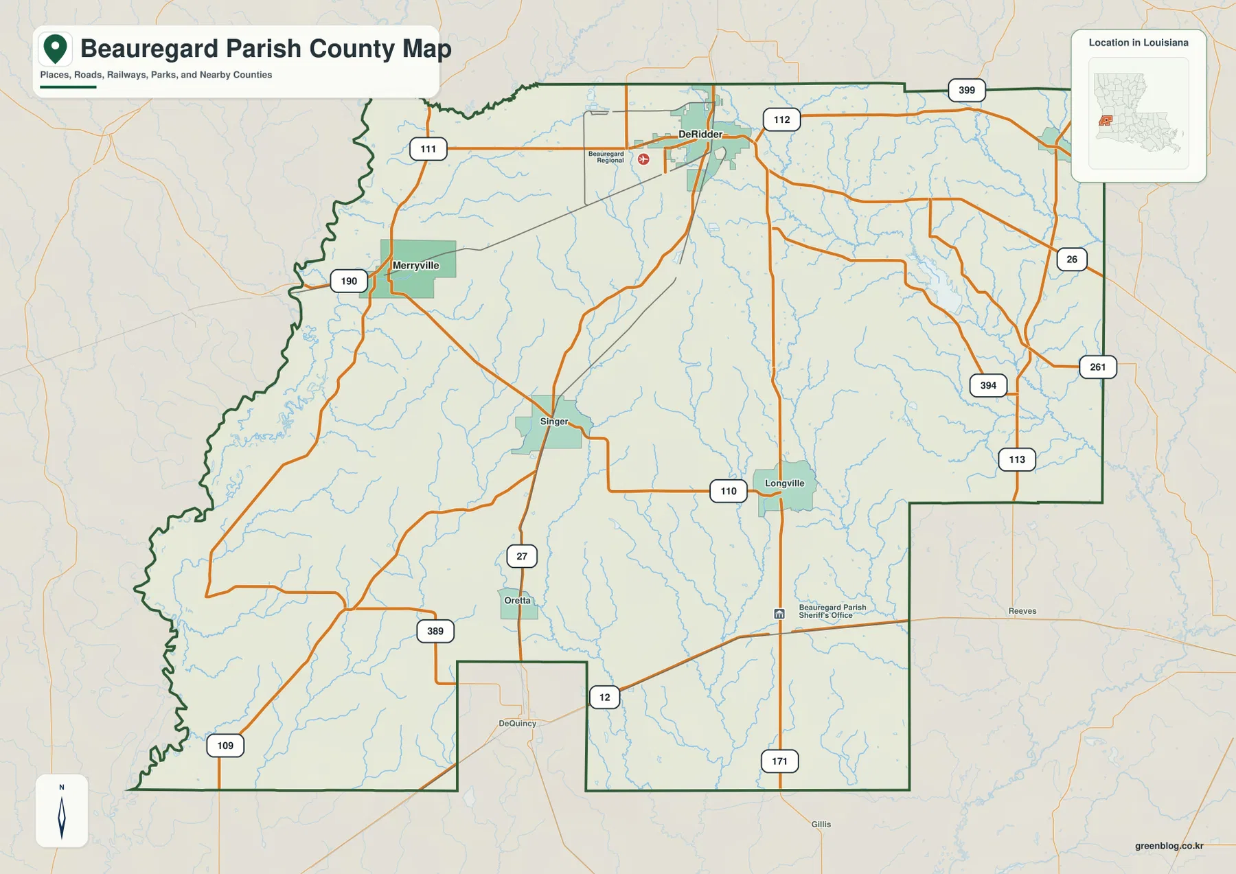
DeRidder is the clearest place to begin reading the general map. US 190 enters from the Merryville side and continues through DeRidder, while US 171 forms the stronger north–south reference. LA 112 and several local roads also converge near the city, and Beauregard Regional Airport appears just outside the built-up area.
Merryville lies west of DeRidder near US 190 and LA 111. Singer sits farther south, with LA 27 continuing toward Oretta. LA 389 and LA 109 add more references across the southwest, where the parish outline becomes irregular near the Sabine River. Roads in this section bend more often than the straighter connections around DeRidder because they have to work around stream valleys and the river boundary.
Longville provides a useful reference in the east-central part of the parish along LA 110. LA 113, LA 394, LA 261, and LA 26 appear farther east, while US 171 and LA 12 connect the southern side with communities beyond the parish. The spacing between roads increases away from DeRidder, reflecting a more rural landscape crossed by many small creeks.
The general map is intended for geographic orientation rather than live navigation. It does not show current traffic, construction, speed limits, or private access conditions, so a current road service should be used for driving decisions.
DeRidder and Merryville are the two major-city references on the distribution map
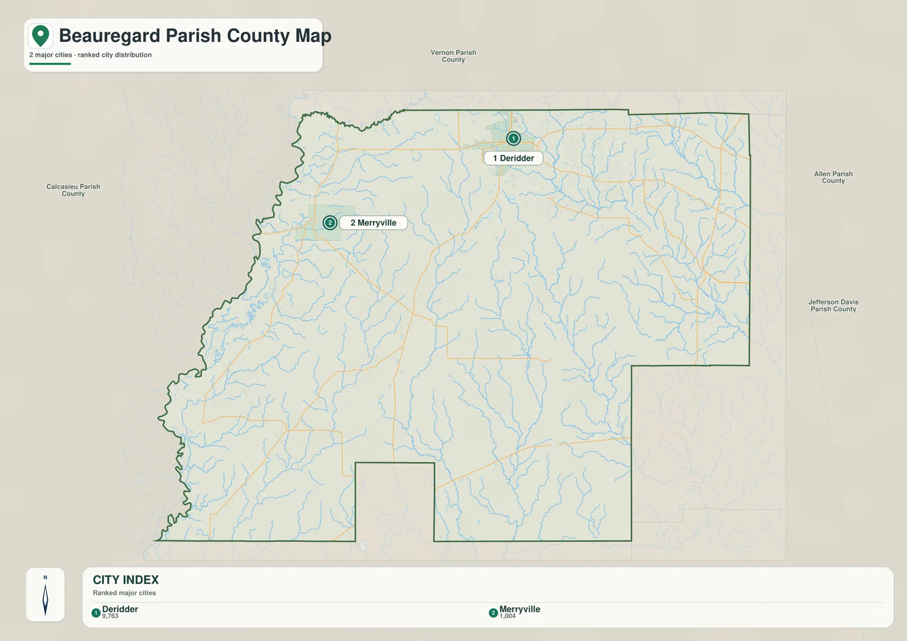
The city-distribution map removes most route labels and highlights DeRidder and Merryville. DeRidder sits near the north-central part of the parish, while Merryville lies much closer to the western boundary. Their spacing makes it clear that the parish is not one continuous urban area; most of the land between and around them is rural.
Louisiana’s official Beauregard Parish profile identifies DeRidder as both the parish seat and a city, with Merryville listed as a town. The Beauregard Parish Police Jury also maintains its administrative office in DeRidder, reinforcing the city’s role as the primary civic reference for the parish.
Vernon Parish appears to the north, Allen and Jefferson Davis Parishes are east, and Calcasieu Parish is shown toward the southwest. The western edge follows the Sabine River side of Louisiana, placing Beauregard Parish between the Lake Charles region and the Louisiana–Texas boundary.
The population figures printed in the city index belong to the source snapshot used to create the map and should not be treated as current official totals. Recent demographic comparisons should use the U.S. Census Bureau. The main purpose of this file is to show the relative placement of DeRidder and Merryville.
Sabine River, Bundick Creek, and interior lakes shape the water map
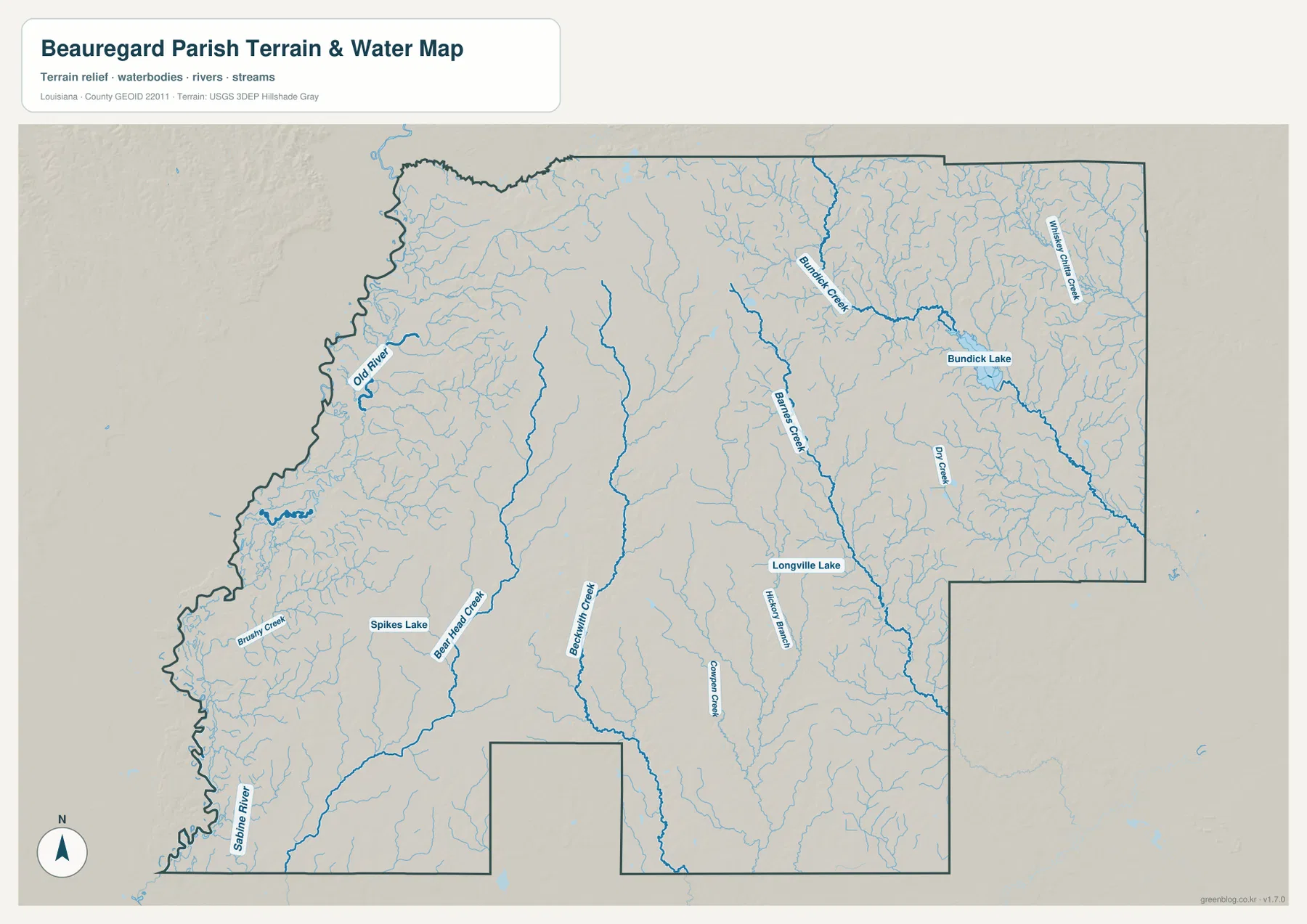
The Sabine River is the strongest water reference on the western side. It follows much of the southwestern boundary, while Old River appears farther north as a separate winding channel. Numerous small tributaries reach toward the border, helping explain the irregular outline visible on the general parish map.
Brushy Creek, Bear Head Creek, and Beckwith Creek provide long interior references across the western and central portions of the parish, with Spikes Lake nearby. These streams collect many short tributaries, so the water map looks much denser than the road map in rural areas around Singer and Oretta.
The eastern half is organized around a different set of waterways. Bundick Creek runs through Bundick Lake and continues southeast, while Whiskey Chitto Creek is prominent in the northeast. Barnes Creek extends southward through the interior, Longville Lake appears near the Longville area, and smaller features such as Dry Creek, Hickory Branch, and Cowpen Creek fill the gaps between the larger streams.
This terrain-and-water file is a geographic reference, not a flood-insurance map, depth chart, navigation product, legal shoreline record, or parcel survey. Current flood, boating, access, and property-boundary questions should be checked with FEMA, USGS, or local parish sources.
Three parts of the parish show different road-and-water relationships
Around DeRidder, roads are the easiest features to follow. US 190, US 171, LA 112, and local connections create the parish’s most recognizable transportation center. The City of DeRidder’s official site provides local civic and transportation information, while the map shows how the city connects west toward Merryville and south toward the rest of Beauregard Parish.
The Merryville–Singer side is shaped more strongly by the Sabine River and its tributaries. US 190 and LA 27 remain useful road references, but Brushy Creek, Bear Head Creek, and the river boundary become increasingly important farther west. Comparing the road and water maps explains why routes in this area often curve around stream corridors instead of following a regular grid.
Longville and the eastern side are associated with Bundick Creek, Barnes Creek, Bundick Lake, and Whiskey Chitto Creek. LA 110 gives the road map a clear east-central reference, but the terrain-and-water file reveals how many separate drainage lines cross the same area. Looking at all three sections shows that Beauregard Parish contains several distinct water systems rather than one dominant river corridor.
Choose the Beauregard Parish file that matches the detail you need
The general map is the best starting point for DeRidder, Merryville, smaller communities, highways, and the parish outline. The city map is cleaner when the two major city references are the main concern. The terrain-and-water map is the strongest choice for the Sabine River, Bundick Creek, Whiskey Chitto Creek, named lakes, and the dense tributary network.
- General map: Use it for DeRidder, Merryville, Singer, Longville, Oretta, US 190, US 171, LA 27, LA 110, LA 111, LA 112, LA 113, LA 109, LA 389, and LA 394.
- City map: Use it to compare DeRidder and Merryville and to see the directions of Vernon, Allen, Jefferson Davis, and Calcasieu Parishes.
- Terrain and water map: Use it for Sabine River, Old River, Brushy Creek, Bear Head Creek, Beckwith Creek, Barnes Creek, Bundick Creek, Whiskey Chitto Creek, Bundick Lake, Longville Lake, and Spikes Lake.
Each original JPG measures 3638 × 2572 pixels in landscape orientation, preserving more small road and waterway labels than the web previews. Keeping the original aspect ratio is recommended for printing. When using all three files, start with DeRidder and Merryville, then compare the Sabine River side with the Bundick Creek and Bundick Lake side.
Frequently Asked Questions
Which map is best for DeRidder, Merryville, and US 190?
The general parish map is the best choice because it combines DeRidder, Merryville, Singer, Longville, US 190, US 171, LA 27, LA 110, LA 111, LA 112, and other major roads in one view.
Where can I see the Sabine River and Bundick Lake most clearly?
The terrain-and-water map shows Sabine River, Old River, Bundick Creek, Bundick Lake, Whiskey Chitto Creek, Barnes Creek, Bear Head Creek, Longville Lake, and other tributaries. It is a geographic reference rather than a flood, depth, navigation, or legal-boundary map.
Why does the city map show only DeRidder and Merryville?
The city-distribution file uses a simplified major-city index and highlights only those two places. Singer, Longville, Oretta, and other communities remain visible on the general map, while current population totals should be checked with the U.S. Census Bureau.
Map File Information
The ZIP contains high-resolution JPG versions of the Beauregard Parish general map, city-distribution map, and terrain-and-water map. Use the previews to check DeRidder, Merryville, major roads, the Sabine River, Bundick Creek, and Bundick Lake before opening the original files.
- Included Files: Use only the versions confirmed in the article and supplied images
- File Type: Use the confirmed download contents
- Intended Use: Printing, education, presentations, and map-based projects
Related Maps
Sources and references
The geographic discussion is based primarily on the supplied Beauregard Parish maps, with official parish and DeRidder pages plus federal boundary and hydrography sources used for context.
- Beauregard Parish Police Jury — official parish government and local information.
- Louisiana.gov – Beauregard Parish — official parish profile, parish seat, and municipality list.
- City of DeRidder official website — official city information and services.
- U.S. Census Bureau TIGER/Line Shapefiles — official geographic boundary and road data.
- USGS National Hydrography — federal hydrography background for rivers, creeks, lakes, and water features.
Green Map creates custom-edited map images using open geographic data sources such as geoBoundaries, Natural Earth, OpenStreetMap, and government open data. These maps are edited visual materials, not raw data files, and are provided for education, documents, presentations, and graphic reference.