Trimble County is a compact northern Kentucky county where two small cities, a major river boundary, rolling uplands, and a dense network of creeks fit into a relatively small area. This Trimble County Map collection shows Milton and Bedford, US 421, KY 36 and KY 42, the Ohio River, the Little Kentucky River, and terrain ranging from about 129 to 295 meters. The four maps separate roads, city distribution, waterways, and elevation so each part of the county can be examined without crowding every detail into one image.
The map files are available as high-resolution JPG downloads after the web previews. Trimble County’s official government describes the county as a place shaped by agriculture and history, while the supplied maps add a strong physical-geography story: the Ohio River wraps around the west and north, narrow valleys cut into the interior, and higher ridges rise quickly away from the river bottoms. Milton and Bedford occupy different parts of that landscape, which makes them useful anchors for comparing the maps.
Table of Contents
US 421 links riverside Milton with inland Bedford
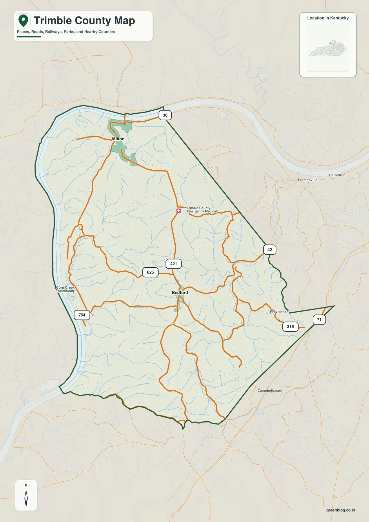
Milton and Bedford are the clearest settlement references on the general county map. Milton sits near the Ohio River at the northern end of the county, while Bedford lies farther south in the interior. US 421 provides the easiest north–south line to follow because it passes through the Milton area and continues toward Bedford. Near Milton, KY 36 supplies an east–west reference, and around Bedford, KY 42 and several smaller roads spread toward the county edges.
Additional route numbers make the local network easier to understand. KY 625 appears west of Bedford, and KY 754 runs closer to the western river side. On the eastern side, KY 316 and KY 71 approach the pointed southeastern part of the county. Providence is labeled near that side of the map, while the surrounding road pattern shows how Bedford functions as an inland junction rather than a riverfront town.
The Ohio River is impossible to miss along the county’s western and northern edge. It forms a broad curved boundary, and Milton sits just inside that river landscape. Bedford, by contrast, is surrounded by smaller creeks and upland roads. That difference matters when reading the map because a route that looks short in straight-line distance may still cross rolling terrain or follow a winding creek valley once it leaves the river bottom.
Names outside the boundary give useful regional context. Carrollton and Prestonville appear to the east, and Campbellsburg lies farther southeast. Across the Ohio River is Indiana rather than another Kentucky county. The general map is intended for geographic orientation, not live navigation: it does not display current traffic, construction, road restrictions, speed limits, or private access conditions.
Milton and Bedford stand out as the two major-city references
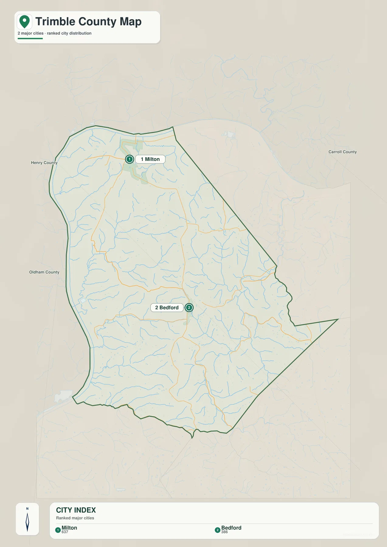
The city-distribution map removes most road labels and highlights just two major-city references: Milton and Bedford. Milton is placed close to the northern river bend, while Bedford sits much farther inland near the middle of the county. The simplified view makes the contrast easy to grasp before returning to the more detailed road or terrain maps.
Neighboring county labels also help position Trimble County within northern Kentucky. Henry County is shown to the west-southwest side, Oldham County lies to the southwest, and Carroll County is east of the county. The Ohio River separates much of the west and north side from Indiana, so Trimble County does not have Kentucky counties surrounding it in every direction. That river boundary is a defining part of both its shape and its regional setting.
The numbers printed in the city index belong to the source snapshot used to produce this map and should not be treated as current official population totals. Up-to-date demographic work should use the U.S. Census Bureau or another current official dataset. Here, the city map is best used to answer a spatial question: where are Milton and Bedford relative to the river, the county boundary, and each other?
The Ohio and Little Kentucky rivers frame a dense creek network
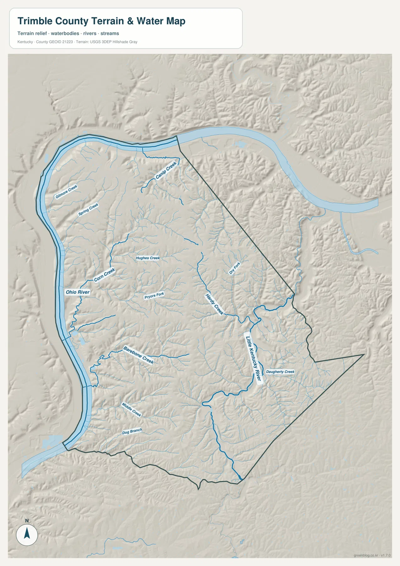
The terrain-and-water map puts the Ohio River at the center of the county’s physical geography. The river follows the western side and then bends around the north, creating a long strip of low ground beside the county. Narrow tributary valleys cut eastward and southward from that river edge, so the interior is divided into many ridges rather than one broad upland surface.
Several named creeks help organize the interior. Corn Creek, Hughes Creek, Spring Creek, Canip Creek, and Barebone Creek appear in different parts of the county. Their channels occupy low corridors between the ridges visible in the shaded relief. Some drain toward the Ohio River, while others connect with the Little Kentucky River system on the eastern side. This split between two larger river systems is one reason the county has so many short branching valleys.
The Little Kentucky River is especially prominent toward the east and southeast, where it bends through a broad low corridor. Daugherty Creek joins that general drainage area, and Dry Fork is labeled farther north. Comparing these waterways with the road map shows why some local roads curve and change direction even though the county itself is small: the roads are working through a landscape repeatedly cut by creek valleys.
This file is a water-reference and terrain map, not a flood-insurance map, legal shoreline record, navigation chart, or parcel map. It should not be used to determine flood risk, water depth, boating conditions, private property, or regulatory boundaries. For those questions, current agency data should be used. The map’s purpose is to show where the main rivers and named creeks lie and how they fit into the surrounding relief.
A 129–295 meter elevation range separates river bottoms from upland ridges
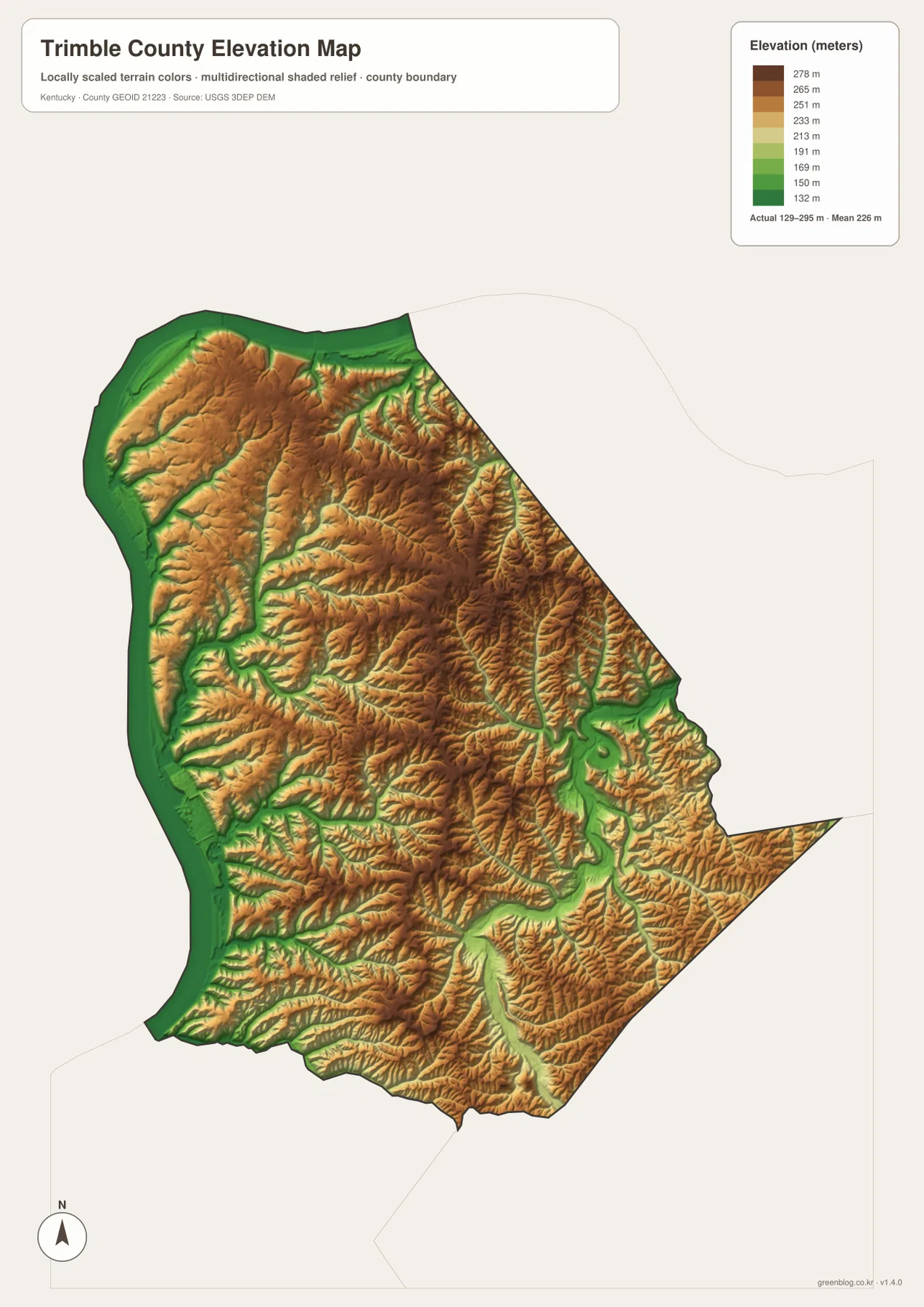
The elevation legend reports an actual county range of about 129 to 295 meters, with a mean near 226 meters. Green marks the lower ground, while yellow, orange, and brown shades represent progressively higher terrain. The broadest low zone follows the Ohio River along the west, with another conspicuous low corridor tracing the Little Kentucky River on the east.
Moving inland from either major river, elevation rises quickly into a network of narrow ridges. Those ridges are not continuous flat plateaus. Creek valleys cut into them from many directions, producing a branching pattern of green lowlands surrounded by warmer-colored slopes and ridge tops. Corn Creek, Hughes Creek, Barebone Creek, and other tributaries that were blue lines on the water map appear again as lower corridors on the elevation map.
The central and northeastern uplands contain some of the stronger concentrations of higher terrain. Near the Little Kentucky River, however, the colors drop abruptly into a winding green valley before climbing again on the opposite side. The southern half shows the same general pattern at a smaller scale: elongated valleys run between higher ridges, which helps explain why the local road network often follows bends rather than straight lines.
The 129–295 meter range is appropriate for county-scale comparison, but this surface is generalized and not survey-grade. It should not be used to establish a building elevation, bridge height, drainage design, or parcel-level engineering value. Detailed work should rely on the underlying USGS 3D Elevation Program data at a suitable resolution and, when required, professional field survey measurements.
Following Milton, Bedford, and the river valleys across the map set
A practical way to compare the four files is to start at Milton. On the general map, Milton is a northern community tied to US 421 and KY 36. On the water map, the same location is immediately adjacent to the Ohio River. On the elevation map, the river corridor is one of the lowest parts of the county. The same place therefore connects transportation, settlement, water, and relief in a very direct way.
Bedford provides a different comparison. It is farther from the Ohio River, surrounded by a branching road network and numerous small creek valleys. The terrain map shows a more dissected interior landscape around it, while the elevation map places Bedford among higher uplands separated by lower drainage corridors. Following US 421 between Milton and Bedford shows a transition from the northern river setting into the interior hills.
The eastern edge offers a third reference point. KY 42 and the roads near KY 316 and KY 71 approach the Little Kentucky River side, where a broad green valley stands out on the elevation map. This area looks different from both the Ohio River frontage and the central uplands. For a classroom or local overview, comparing those three settings—Milton by the Ohio, Bedford in the interior, and the Little Kentucky River valley to the east—captures much of Trimble County’s geographic character without relying on a long list of road names.
Choosing the Trimble County map file that fits the task
The general county map is the best choice when roads, communities, and the county outline need to be visible together. The city map is simpler when the goal is to show the positions of Milton and Bedford. The terrain-and-water map emphasizes the Ohio River, Little Kentucky River, and named tributaries, while the elevation map makes the low river corridors and higher interior ridges much easier to compare.
- County map: Use it for Milton, Bedford, US 421, KY 36, KY 42, KY 625, KY 754, KY 316, KY 71, and the county boundary.
- City map: Use it to compare Milton and Bedford and to show the neighboring Henry, Oldham, and Carroll County directions.
- Terrain and water map: Use it for the Ohio River, Little Kentucky River, Corn Creek, Hughes Creek, Spring Creek, Barebone Creek, and other tributaries.
- Elevation map: Use it to compare the 129–295 meter relief, especially low river bottoms and higher interior ridges.
Each original JPG is 2572 × 3638 pixels in portrait orientation, so the downloaded files preserve more labels and terrain detail than the web previews. Keeping the original aspect ratio is recommended for print use. When several maps are used together, a useful order is roads and settlements first, the two-city distribution second, waterways third, and elevation last so the same locations can be followed from one theme to the next.
Frequently Asked Questions
Which map is best for Milton, Bedford, and US 421?
The general county map is the best option because it combines Milton, Bedford, US 421, KY 36, KY 42, and the county boundary in one view. The city map is better when only the relative positions of Milton and Bedford are needed.
Where are the Ohio River and Little Kentucky River easiest to see?
The terrain-and-water map shows both major rivers along with Corn Creek, Hughes Creek, Spring Creek, Barebone Creek, Daugherty Creek, and other tributaries. It is a geographic reference map rather than a flood, depth, navigation, or legal-boundary product.
Can the 129–295 meter elevation map be used for engineering or surveying?
No. The elevation map is designed for county-scale comparison of low valleys and higher ridges. Its approximately 129–295 meter range and 226 meter mean describe regional relief, but engineering, drainage, construction, and property-level survey work require more precise source data and appropriate field measurements.
Map File Information
The ZIP contains high-resolution JPG versions of the Trimble County general map, city map, terrain-and-water map, and elevation map. Use the previews to check Milton, Bedford, major roads, the Ohio and Little Kentucky rivers, and the 129–295 meter relief before selecting the original files.
- Included Files: Use only the versions confirmed in the article and supplied images
- File Type: Use the confirmed download contents
- Intended Use: Printing, education, presentations, and map-based projects
Related Maps
Sources and references
The geographic discussion is based primarily on the supplied Trimble County maps, with official county, city, boundary, hydrography, and elevation sources used for context.
- Trimble County Fiscal Court — official county information, history, and local context.
- City of Milton — official information about Milton and its Ohio River location.
- U.S. Census Bureau TIGER/Line Shapefiles — official geographic boundary and road data.
- USGS National Hydrography — federal hydrography background for rivers, creeks, and water features.
- USGS 3D Elevation Program — federal elevation and terrain data program.
Green Map creates custom-edited map images using open geographic data sources such as geoBoundaries, Natural Earth, OpenStreetMap, and government open data. These maps are edited visual materials, not raw data files, and are provided for education, documents, presentations, and graphic reference.