Bracken County occupies a deeply dissected corner of northern Kentucky along the Ohio River. Augusta sits on the riverfront, Brooksville serves as the inland county seat, and Germantown lies near the eastern Mason County line. KY 8 follows the Ohio River, while KY 9, KY 10, KY 19, KY 22, KY 165, KY 352, KY 435, KY 539, KY 546, and KY 875 cross a dense network of narrow creek valleys and ridges. High-resolution map files are available for download in the section below.
This guide follows Augusta, Brooksville, Germantown, the Ohio River, Locust Creek and other interior waterways, and relief ranging from about 144 to 303 meters. WebP previews are included for quick viewing, and the same maps can be downloaded as high-resolution JPG files in one ZIP for printing, classroom work, or close study.
Table of Contents
Augusta occupies the Ohio River edge while Brooksville anchors the inland county government
Augusta lies directly on the Ohio River, with KY 8 tracing the riverfront corridor. The developed strip is narrow because the hills rise quickly south of town. Brooksville sits farther inland near the county center, where KY 19 and several local routes meet, and the Bracken County Clerk and county government maintain their primary offices.
The Kentucky county formation record lists Bracken County as a 1797 county created from Campbell and Mason counties, with Brooksville as the county seat. Augusta had been an earlier political and commercial center, but the shift of county government inland left the county with two very different focal points: a historic river town and a hill-country administrative center.
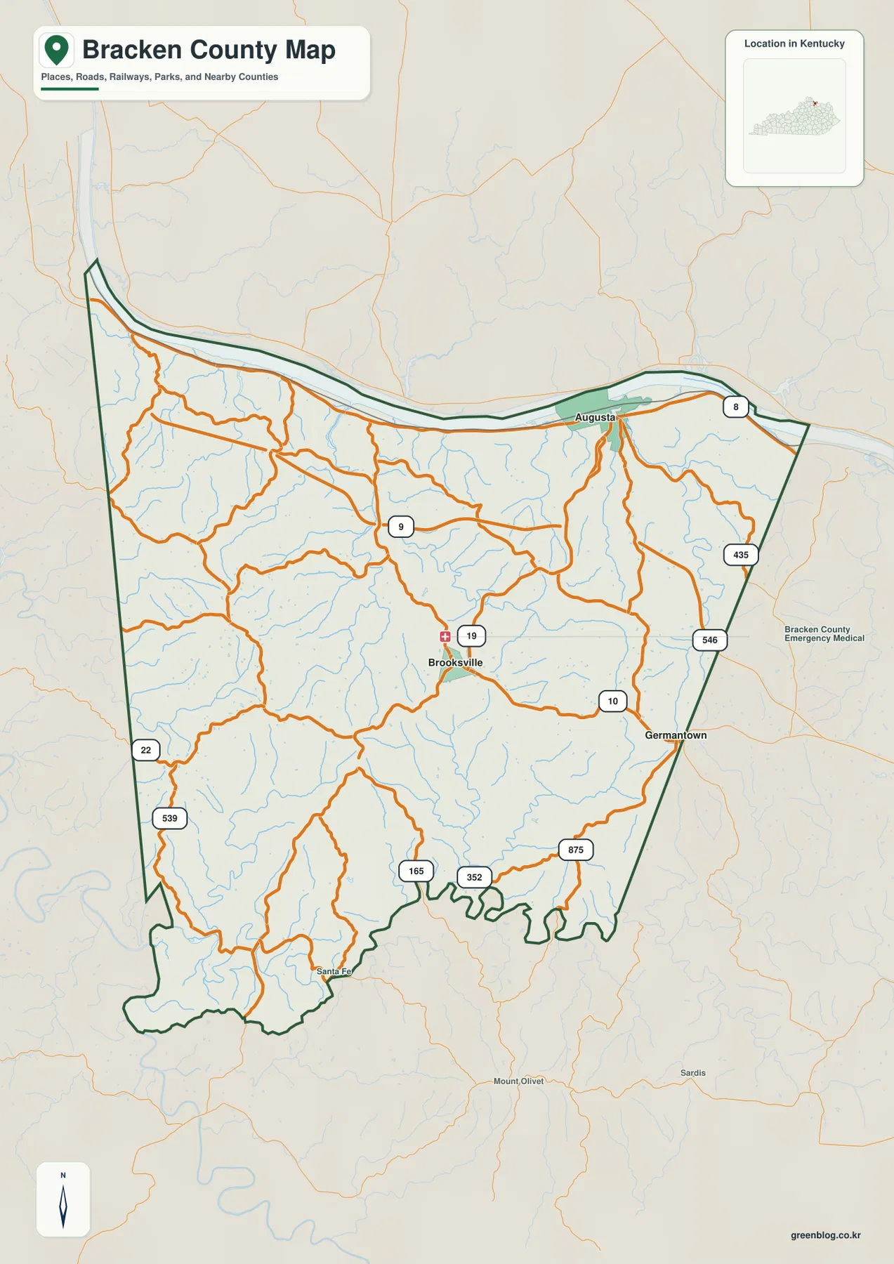
Germantown sits near the Mason County line along the KY 10 side, while Santa Fe appears in the southern countryside. Robertson and Pendleton counties border the west and Harrison County borders the south, so travel from Brooksville can lead toward the Ohio River, the Licking River system, or increasingly rugged interior hills.
The city-connections panel uses Augusta as the hub for Brooksville and Germantown
The supplied city panel places Augusta at an index value of 1,510, Brooksville at 883, and Germantown at 232. These are map index values rather than current official population estimates. Brooksville is labeled about 7 miles from Augusta and Germantown about 8 miles away in straight-line map distance; neither figure represents driving distance.
The short straight-line spacing hides substantial terrain differences. Augusta occupies the low Ohio River edge, Brooksville sits among inland hills, and Germantown lies toward the eastern drainage network near Mason County. Roads between them follow ridges and creek valleys rather than direct lines.
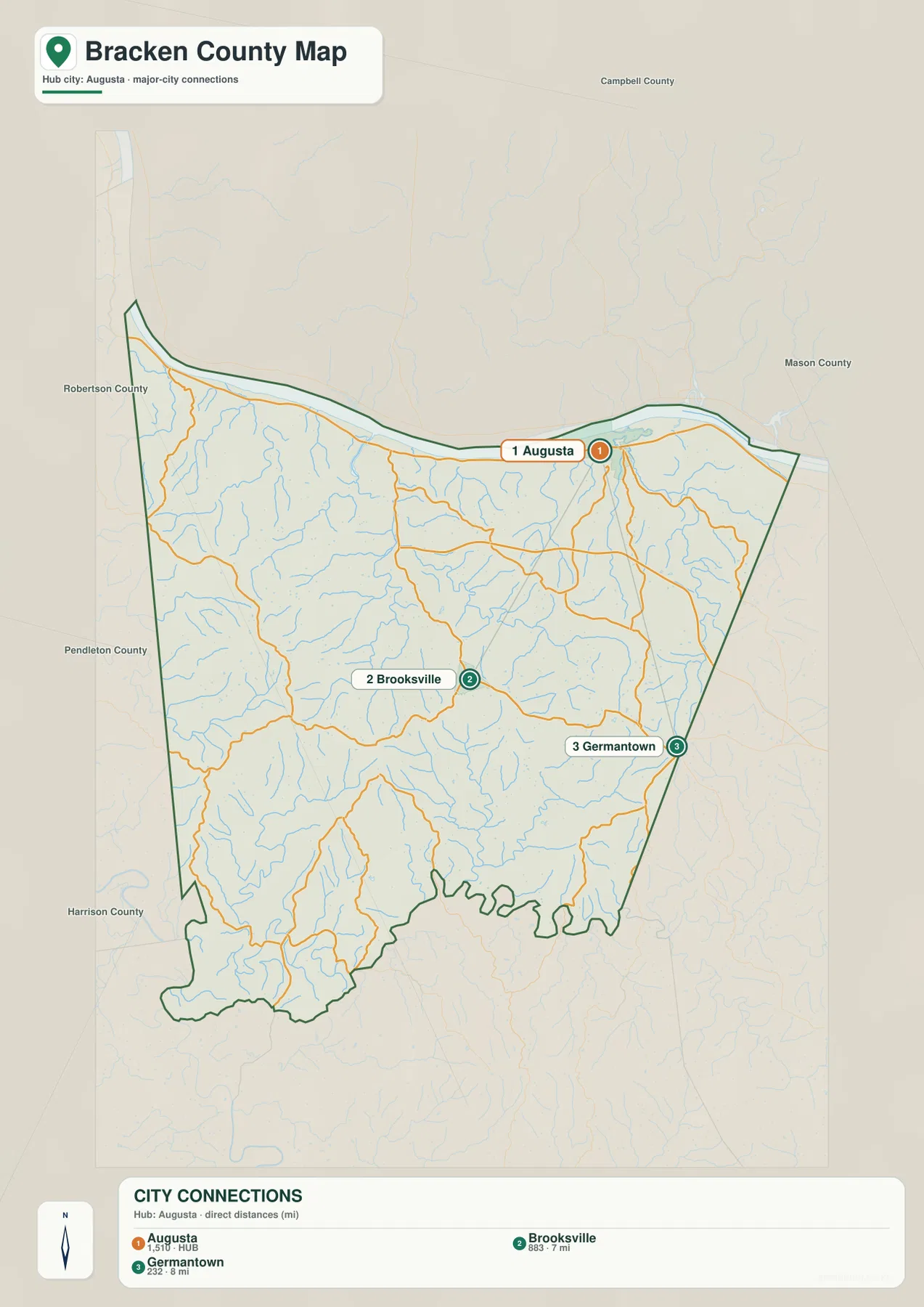
The panel is a simplified major-place view rather than a complete settlement list. Brooksville’s role as county seat and Germantown’s position on the eastern edge are better understood when the city panel is compared with the road and terrain maps.
The Ohio River defines the north while Locust Creek and Bracken Creek cut the interior hills
The Ohio River is the dominant water feature along the northern border. Augusta occupies its low bank, but the land rises quickly away from the river. A dense web of short tributaries cuts the uplands south of the river, creating the strongly ridged surface visible across most of the county.
Locust Creek is one of the clearest interior waterways, joined by Goose Creek and Opposum Trot Branch. Bracken Creek and Little Bracken Creek drain the eastern side, while Kincaid Creek crosses the west and Willow Creek occupies the southwest. Brooksville Reservoirs appear near the center-south, with Camp Creek and Willow Branch providing additional southern references.
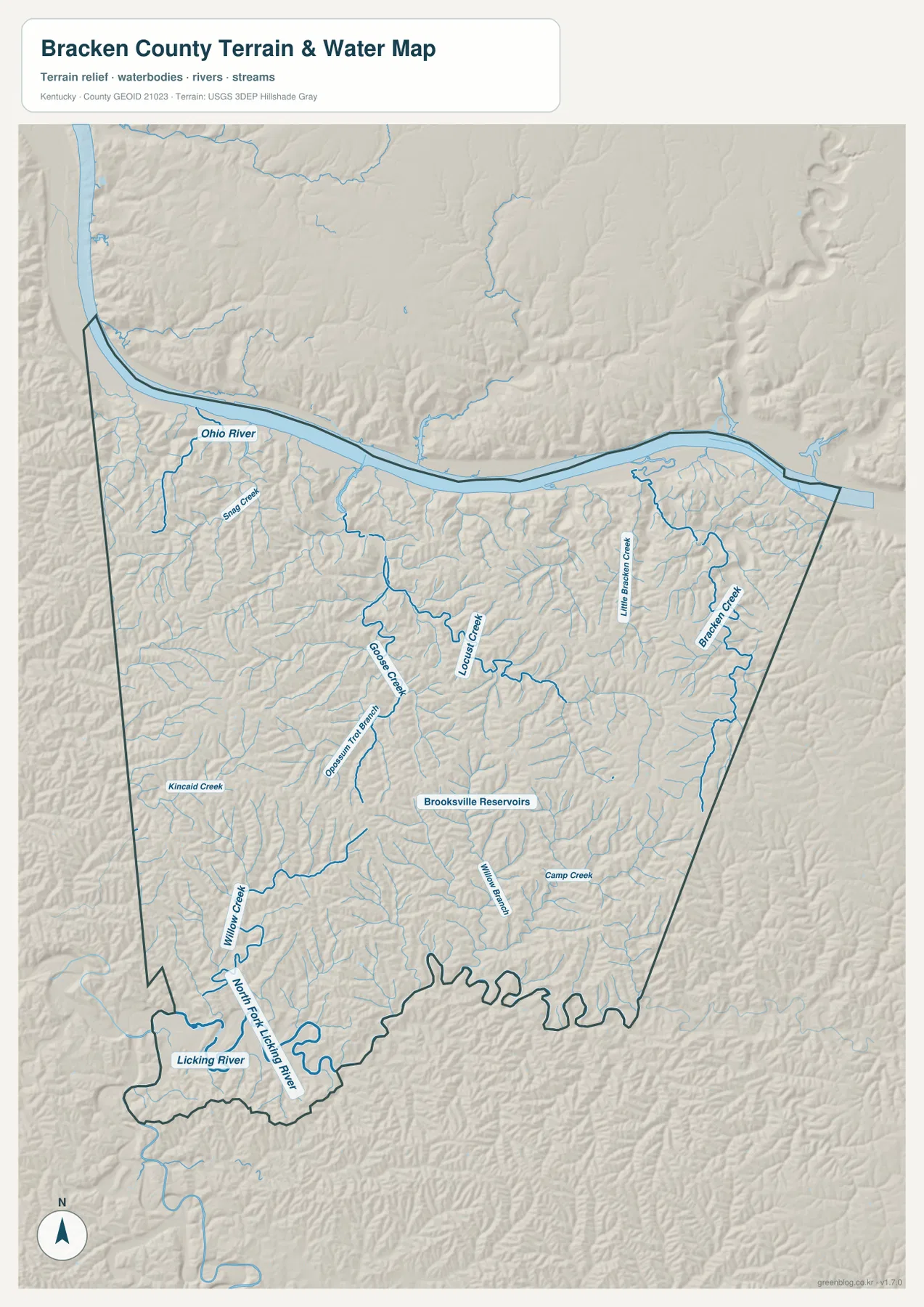
The southwestern corner reaches the Licking River and North Fork Licking River system. Those low corridors contrast with the higher interior between the Licking and Ohio river basins, where short ridges and narrow hollows repeatedly divide the landscape.
This image is intended for geographic reference rather than floodplain, navigation, water-quality, parcel, or legal-boundary decisions. Current agency information should be used whenever river stage, access, safety, or property decisions depend on water conditions.
Elevation from 144 to 303 meters rises sharply from the river bottoms into dissected hill country
The elevation surface ranges from about 144 to 303 meters, with a mean near 242 meters. A dark green low strip follows the Ohio River, but tan and brown hills appear almost immediately to the south. Across the center, east, and west, closely spaced ridges are separated by a branching network of lower creek valleys.
Brooksville sits on moderately elevated interior terrain rather than on the highest ridge crests, with Locust Creek and smaller tributaries nearby. Augusta occupies a much lower riverfront setting, and the Bracken Creek side of the county shows another long series of valleys cutting into the uplands.
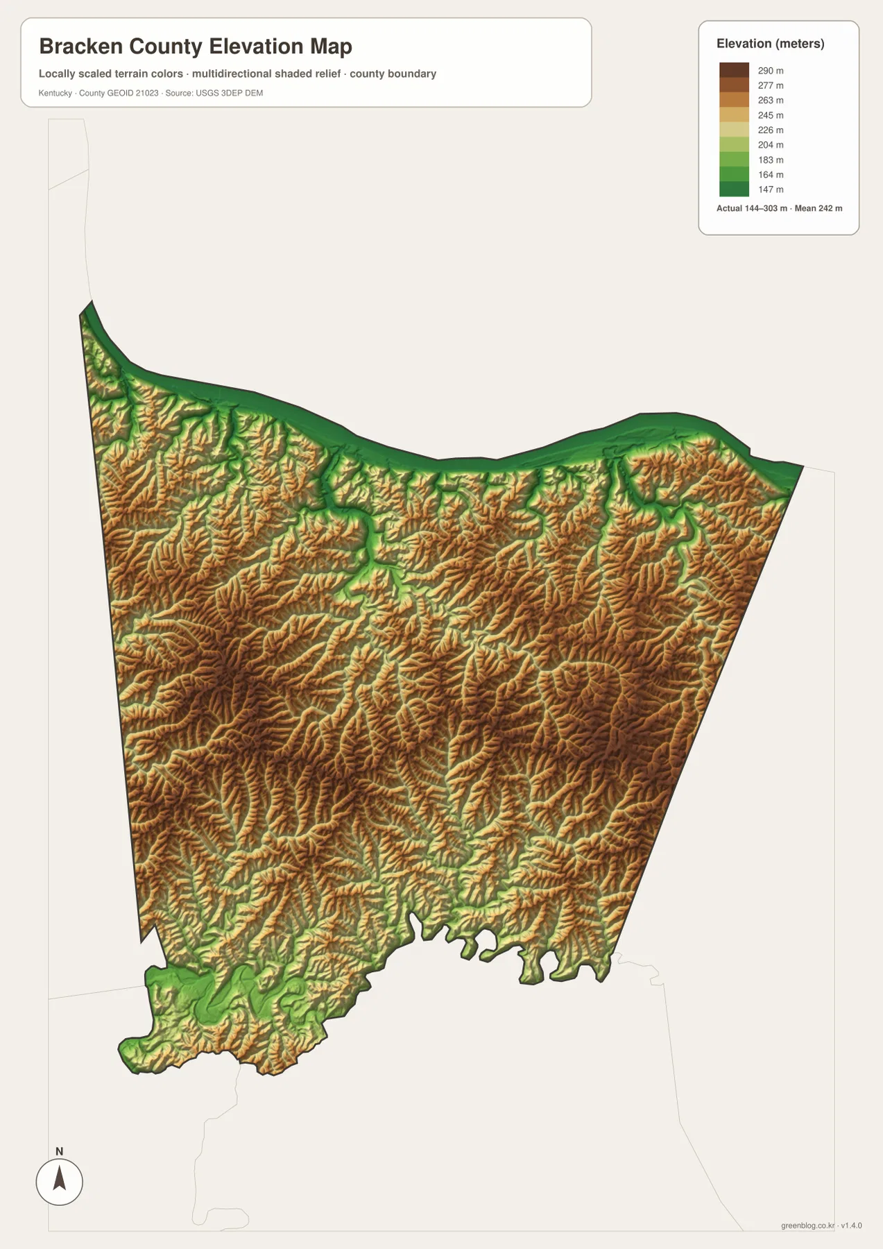
The Licking River corner drops again in the southwest, but much of the land between the two major river systems remains strongly dissected. That pattern explains why a short trip inland from Augusta can feel much hillier than the distance suggests and why many local roads bend through hollows and lower saddles.
The elevation surface is generalized for county-scale comparison. It is not survey-grade or engineering-grade measurement and should not be used for parcel elevations, construction grades, drainage design, or legal boundary work.
Augusta preserves the county’s Ohio River history
The Kentucky Historical Society’s Bracken County marker records the county’s formation from Campbell and Mason counties and notes several important Augusta connections, including Augusta College, founded in 1822. Kentucky Tourism continues to present Augusta as a historic Ohio River town with a preserved riverfront and nineteenth-century architecture.
The map helps explain why Augusta developed differently from Brooksville. Its narrow built-up area hugs the Ohio River, where trade and river travel once offered advantages that inland hill communities did not have. Even after county government moved to Brooksville, Augusta remained an important river community.
Today the riverfront, Main Street, historic district, and nearby visitor attractions still concentrate within a small area between the Ohio River and the first interior hills, giving Augusta a landscape unlike the rest of rural Bracken County.
Walcott Covered Bridge links Locust Creek with Bracken County’s rural transportation history
A Kentucky Historical Society marker places Walcott Covered Bridge about five miles north of Brooksville over Locust Creek. The 75-foot timber truss served the Walcott community from 1824 until 1954 and was listed on the National Register of Historic Places in 1975.
Locust Creek is one of the central water features on the terrain map, so the bridge provides a useful real-world landmark for understanding the county’s valley network. It also shows how important creek crossings were in a landscape where ridges and hollows could make even short local trips difficult.
Modern roads have changed the transportation system, but the covered bridge remains a tangible reminder that Bracken County communities developed around narrow waterways and practical crossing points long before the present highway network.
White Burley tobacco and John Gregg Fee add distinctive chapters to county history
Bracken County’s official history and the Kentucky Historical Society both connect the county with the development of White Burley tobacco. The strain became a major agricultural product across Kentucky and surrounding states, reinforcing Bracken County’s long association with farming and the burley belt.
The county is also the birthplace of John Gregg Fee, founder of Berea College. Berea College’s official history describes Fee as a Bracken County native who began a one-room school in 1855 with a commitment to interracial and coeducational learning, an institution that eventually became Berea College.
Those stories add depth to a county that might otherwise look simply like Ohio River farmland. Augusta’s river trade, Brooksville’s government role, tobacco agriculture, and Fee’s educational legacy all emerged from the same compact landscape of river bottoms, creek valleys, and steep interior hills.
Travel from Augusta to Brooksville quickly leaves the river bottom for rolling ridges
A trip inland from Augusta begins on the low Ohio River margin and soon climbs into a maze of short ridges divided by tributaries. The change happens over only a few miles, which is why road distance and driving time can feel longer than the straight-line city panel suggests.
East of Brooksville, routes move toward the Bracken Creek and Little Bracken Creek drainage near Germantown. Westbound roads cross the Kincaid Creek side toward Robertson and Pendleton counties, while the southwest drops toward Willow Creek and the North Fork Licking River. Each direction has its own combination of ridges and low valleys.
For posters, classroom prints, or presentation slides, use the original JPG files in the download archive rather than enlarging the web previews. Small route labels, creek names, city-index text, and the elevation legend remain clearer at the higher resolution.
Frequently Asked Questions
Are Augusta 1,510, Brooksville 883, and Germantown 232 current populations?
No. They are map index values supplied with this package rather than current official population estimates. The roughly 7-mile and 8-mile labels are straight-line map distances from Augusta, not driving distances.
Why do Augusta and Brooksville look so different even though they are close together?
Augusta sits on the low Ohio River margin, while Brooksville occupies much higher inland terrain cut by numerous creeks. The 144–303 meter elevation image makes that transition from river bottom to hill country especially clear.
How does Walcott Covered Bridge relate to the terrain map?
The bridge is a historic crossing over Locust Creek north of Brooksville. Locust Creek is one of the county’s strongest interior drainage lines, so the bridge gives a useful physical reference for the narrow valley system shown on the terrain-and-water image.
Map File Information
The archive contains the Bracken County, Kentucky general county map, city-connections map, terrain-and-water map, and elevation map as original high-resolution JPG files.
- Included Files: Use only the versions confirmed in the article and supplied images
- File Type: Use the confirmed download contents
- Intended Use: Printing, education, presentations, and map-based projects
Related Maps
Sources and references
- Bracken County, Kentucky official site — county setting, agriculture, and White Burley tobacco history
- Bracken County Clerk — county government location in Brooksville and Augusta office information
- Kentucky Historical Society: Bracken County — county formation, Augusta College, John Gregg Fee, and White Burley history
- Kentucky Historical Society: Walcott Covered Bridge — covered bridge history on Locust Creek
- Berea College: Early History — John Gregg Fee and the founding of Berea College
- USGS 3D Elevation Program — elevation and terrain reference data
Green Map creates custom-edited map images using open geographic data sources such as geoBoundaries, Natural Earth, OpenStreetMap, and government open data. These maps are edited visual materials, not raw data files, and are provided for education, documents, presentations, and graphic reference.