Carlisle County occupies a distinctive corner of far western Kentucky, where the broad Mississippi River lowlands meet a more dissected interior of short ridges and creek valleys. Bardwell sits slightly west of the county’s center and serves as the county seat, while Arlington provides a second clear reference point near the southern edge. On the general map, U.S. 51 connects those two communities, and the county boundary bends dramatically along the Mississippi River on the west instead of following a simple straight line. High-resolution map files are available for download in the section below.
The maps on this page can be viewed as WebP images, and the original high-resolution JPG versions can also be downloaded together in a ZIP archive for printing or closer inspection. Use the general and city maps when roads and settlement locations matter most; turn to the water and elevation maps when you want to compare the Mississippi floodplain with inland creeks, ridges, and valleys. These are reference maps for geographic context rather than parcel, flood-certification, engineering, surveying, or live-navigation products.
Table of Contents
U.S. 51 links Bardwell and Arlington while KY 80 crosses the southern county
U.S. 51 is the easiest road to use as a north-south reference in Carlisle County. It runs through Bardwell and continues south to Arlington, tying the two principal cities on the map to the same corridor. Around Bardwell, several local and state routes branch away from the main road, and the Carlisle County Courthouse is marked nearby. In Arlington, KY 80 crosses U.S. 51 and creates a strong east-west reference, making the southern city useful for understanding how traffic can move toward the Mississippi side of the county or toward communities farther east.
Other routes fill in the rural parts of the county without creating the dense street network found in metropolitan areas. KY 123 approaches Bardwell from the southwest, while KY 62 passes through the northeastern part of the county near Cunningham and Scotts Corner. KY 849, KY 121, and KY 307 are prominent on the eastern half of the general map. Because wide rural spaces separate these routes, road numbers and named communities work best together when you are trying to place a location that is outside Bardwell or Arlington.
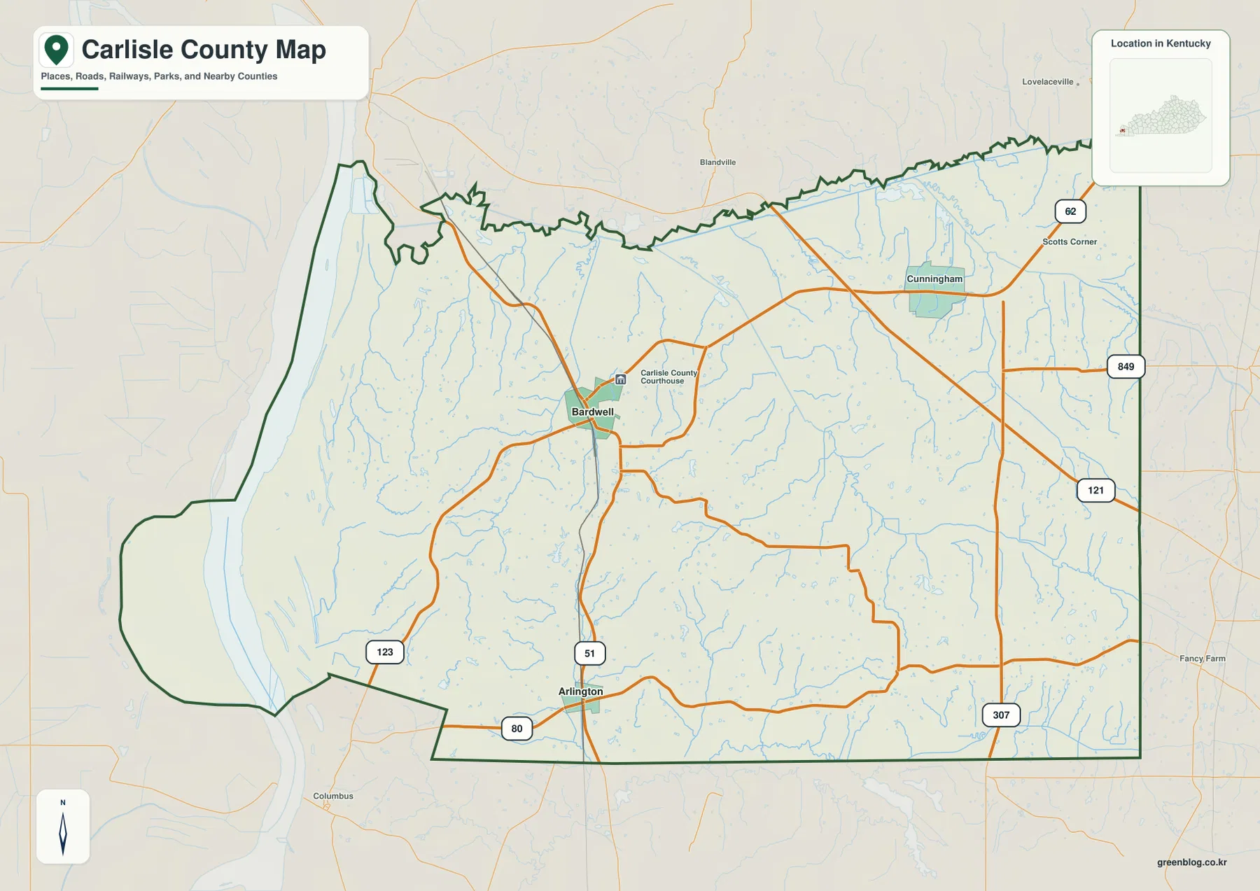
The western county line is especially useful for orientation because it follows the Mississippi River and includes several pronounced bends. A broad projection on the southwest side reaches toward the river, while the eastern edge of the county contains longer, straighter boundary segments. This contrast makes the county look very different from a rectangular grid county. It also explains why locations that appear equally far from Bardwell in a simple east-west comparison can sit in very different river, road, and terrain settings.
Carlisle County was created from Ballard County in 1886, and Bardwell is the county seat. Kentucky’s official county-formation chart lists Carlisle as the 119th county in the Commonwealth, while the county’s own regional website emphasizes the Mississippi River as its western boundary. Those facts align closely with the map: Bardwell lies in a practical interior position, and the county stretches from river bottoms on the west to rolling uplands and creek-cut terrain farther east.
Bardwell and Arlington form a simple two-city frame for a mostly rural county
The city map deliberately reduces the visual detail and highlights Bardwell and Arlington as the two major cities shown in the index. Bardwell is positioned west of center, while Arlington lies near the southern boundary. Their separation is easy to understand because both sit along U.S. 51. Instead of presenting a cluster of similarly sized cities, the map gives Carlisle County a clear two-point structure that works well for readers who first need to know where the principal communities are before studying smaller roads and natural features.
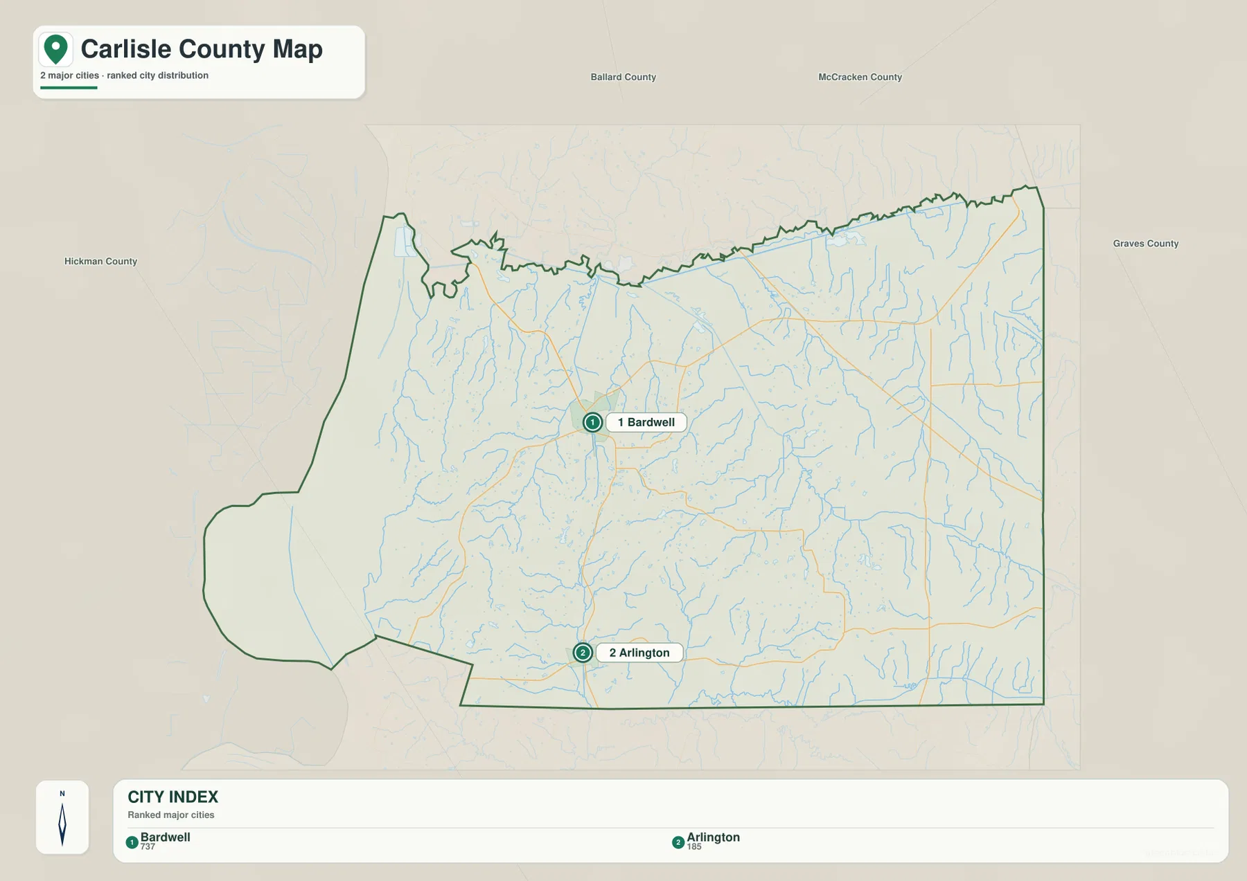
The general map adds context around that two-city framework. Cunningham and Scotts Corner appear in the northeast, and additional roads branch toward the eastern and western rural areas. Arlington is particularly easy to relocate on the general map because U.S. 51 and KY 80 intersect there. Bardwell is easier to recognize by its concentration of connecting roads and the courthouse symbol. For a presentation or handout, the city map may be enough; for route planning at a broad regional scale, the general map gives the additional road labels needed to understand how those places connect.
The county’s own community information describes Bardwell as the county seat and Arlington as a southern agricultural community. That distinction fits what the maps show without requiring a complicated urban hierarchy. Bardwell is the administrative and road reference in the interior, while Arlington anchors the southern end of the county. Looking at them separately also prevents the rural land between the two from disappearing into a generic description of “western Kentucky,” because the map shows how roads, creeks, and terrain change as you move away from each center.
Mississippi River lakes contrast with Truman Creek and the Mayfield Creek drainage
The water map is dominated by the Mississippi River along the western edge. Next to the river, several named water bodies sit within the broad lowland: Forked Lake, Crooked Lake, Indian Camp Lake, Fish Lake, and No 4 Lake. Their concentration gives the western side a very different appearance from the interior. Rather than a single river line with dry land immediately beside it, the map shows a river landscape with lakes, slough-like channels, and low areas that reflect the long influence of the Mississippi floodplain.
Farther inland, named creeks become the main water features. Truman Creek runs through the central-western part of the county, while Hurricane Creek and Lick Creek stand out in the northeast. West Fork Mayfield Creek crosses a large part of the east and southeast, joined by a network of smaller tributaries. Hinton Creek and Little Creek are also labeled. These streams are narrow compared with the Mississippi, but they matter for understanding the interior terrain because they follow the lower valleys between short ridges.
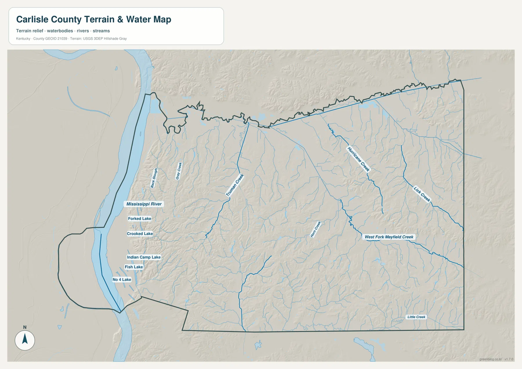
The contrast between west and east becomes clearer when the water and elevation maps are viewed together. Near the Mississippi, broad low surfaces contain the named lakes and elongated water features. Inland creeks occupy narrower valleys, and their tributaries branch into the surrounding uplands. West Fork Mayfield Creek is especially useful as an eastern reference because its course can be traced across several valley segments, while Truman Creek provides a similar anchor closer to the middle of the county.
This water map should not be treated as a current flood, water-level, water-quality, or boating-status map. A creek shown here may change in flow through the year, and the presence of a lake or channel does not establish public access. For property or safety decisions near the Mississippi River or a smaller stream, consult current flood and local agency information. The map is best used to identify names, relative locations, and the broad relationship between water features and the county landscape.
An 89–169 m elevation range separates river bottoms from rolling uplands
The elevation map shows an actual county range of roughly 89 to 169 meters, with a mean near 117 meters. The lowest terrain forms a broad green zone along the Mississippi River on the west. Moving inland, colors shift quickly into lighter greens, tans, and browns as short ridges rise above the bottom lands. Carlisle County is not mountainous, yet the map makes clear that the interior is far from uniformly flat. Local relief is strong enough to create repeated ridges and valleys across much of the central and eastern county.
Higher ground is especially visible immediately east of the Mississippi lowland and in several belts across the middle and east. Narrow green valleys cut between brown and tan ridges, producing a textured pattern that is easy to miss on a road-only map. Truman Creek, West Fork Mayfield Creek, Hurricane Creek, and their tributaries generally occupy those lower corridors. The result is a county where water and relief reinforce one another: the creeks mark the valleys, while the surrounding ridges explain why those valleys remain distinct.
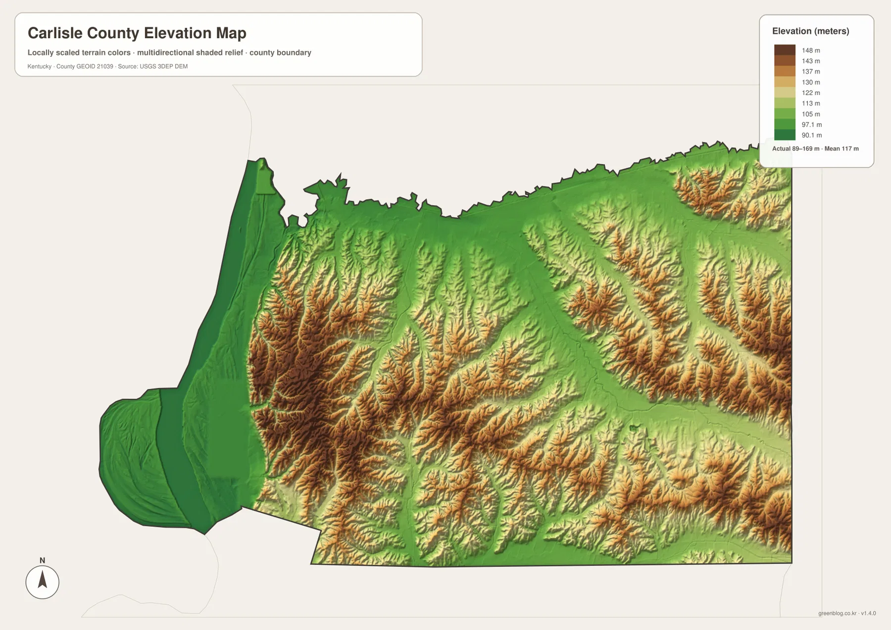
Carlisle County’s regional website describes the landscape in two broad parts: bottom lands beside the Mississippi and uplands shaped by stream erosion. That description is visible in the elevation colors. The western edge is low and comparatively smooth, while the interior contains rolling hills, locally flatter ridge tops, and broad valleys. The county therefore offers a useful example of how a modest absolute elevation range can still produce obvious local terrain differences.
The elevation colors are generalized for county-wide comparison and should not be used as survey-grade measurements. They can help explain why a creek occupies a particular valley or why the Mississippi-side land looks flatter, but they do not provide the precise elevation of an individual building site, road grade, drainage structure, or property corner. Engineering or construction work requires detailed source data such as the USGS 3D Elevation Program and, where necessary, professional field surveying.
Choose the map by the question: routes, settlements, water, or relief
The general map is the best starting point when you need several kinds of information at once. It places Bardwell and Arlington beside U.S. 51, shows KY 80 crossing the south, and adds routes such as KY 62, KY 123, KY 121, KY 307, and KY 849. It also preserves the county outline along the Mississippi River, so a reader can connect roads to the unusual western boundary. If your goal is simply to show where the two principal cities are located, the city map removes most of that extra detail and produces a cleaner visual.
For river and creek questions, the water map is more informative. It identifies the Mississippi River lowland lakes as well as Truman Creek, Hurricane Creek, Lick Creek, West Fork Mayfield Creek, Hinton Creek, and Little Creek. The elevation map answers a different question by showing where the land sits low or rises into ridges. Its 89–169 m range makes the Mississippi bottom lands easy to distinguish from the rolling interior, especially when the map is viewed next to the water layer.
Pairing maps can be more useful than forcing every detail into one image. The general and city maps work well together when introducing Bardwell and Arlington and then adding the road network. The water and elevation maps explain why the western river edge looks different from the interior valleys. The general and water maps can also be compared to see where roads approach or cross named creeks. Choosing the map that matches the question keeps the page readable while still giving enough detail for research, classroom use, presentations, and personal reference.
Frequently Asked Questions
Which map is best for locating Bardwell and Arlington?
The city map is the simplest choice when you only need the relative positions of Bardwell and Arlington. Use the general map when road context matters. U.S. 51 connects the two cities, and KY 80 crosses U.S. 51 at Arlington, so the general map makes it easier to understand how the southern community connects east and west as well as north toward Bardwell.
Why are several small lakes shown near the Mississippi River?
Forked Lake, Crooked Lake, Indian Camp Lake, Fish Lake, and No 4 Lake are grouped in the low western part of the county near the Mississippi River. Carlisle County’s regional information describes this area as bottom land with lakes, ponds, sloughs, and former river-related channels. The map shows their location, but it does not establish current water levels, flood risk, or public access.
What does the 89–169 m elevation map show most clearly?
Its strongest contrast is between the broad, low Mississippi River bottoms on the west and the rolling ridges and creek valleys farther inland. The county mean is about 117 meters, but the color pattern shows meaningful local variation within that modest range. Use it for regional terrain comparison, not for the exact elevation of a property, road, or construction site.
Map File Information
Carlisle County map files
- Included Files: county map, city map, water map, elevation map
- File Type: JPG
Related Maps
Sources and references
Local context for Bardwell, Arlington, the Mississippi River boundary, and Carlisle County’s landscape is available from the Carlisle County regional website and the Kentucky Department for Libraries and Archives county formation chart. Boundary data can be referenced through U.S. Census Bureau TIGER/Line, hydrography through USGS National Hydrography, and elevation through the USGS 3D Elevation Program.
Green Map creates custom-edited map images using open geographic data sources such as geoBoundaries, Natural Earth, OpenStreetMap, and government open data. These maps are edited visual materials, not raw data files, and are provided for education, documents, presentations, and graphic reference.