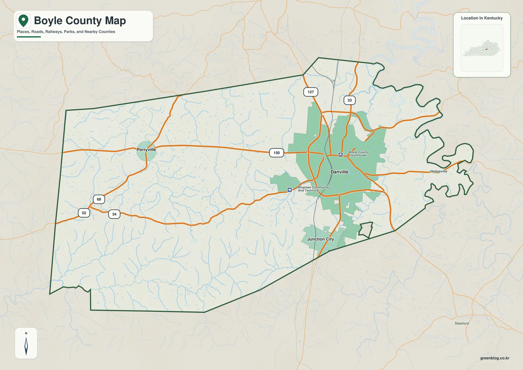
Boyle County sits in central Kentucky, with Danville serving as the county seat and the main road hub. Junction City lies immediately to the south, Perryville anchors the western side, and the landscape becomes much more rugged toward the southwestern Knobs. US 127 runs through Danville, KY 150 links Danville with Perryville, and US 68 with KY 52 and KY 34 provides useful references across the western countryside. High-resolution map files are available for download in the section below.
This guide follows Danville, Junction City, Perryville, the county’s major roads, Chaplin River and Salt River drainage, and terrain ranging from about 202 to 415 meters. WebP previews are included for quick viewing, and the matching high-resolution JPG files can be downloaded together in one ZIP for printing, classroom use, or close map study.
Table of Contents
Danville anchors the road network while Perryville and Junction City define the western and southern sides
Danville occupies the east-central part of Boyle County and functions as the county seat. US 127 runs north–south through the area, while KY 150 crosses west toward Perryville. KY 33 and local routes spread from the city toward the county’s northern and eastern edges, making Danville the most obvious reference point for reading the general map.
Junction City sits only a short distance south of Danville along the US 127 corridor. Perryville is farther west along KY 150, where development becomes more rural and the road network thins. US 68, KY 52, and KY 34 provide additional western references, especially where the county begins to transition into more strongly dissected hills.
Danville’s importance extends beyond transportation. The Danville-Boyle County tourism office identifies Constitution Square as a major statehood landmark, and Centre College is also located in the city. Government, education, and historic sites therefore occupy the same urban center that dominates the county’s road map.
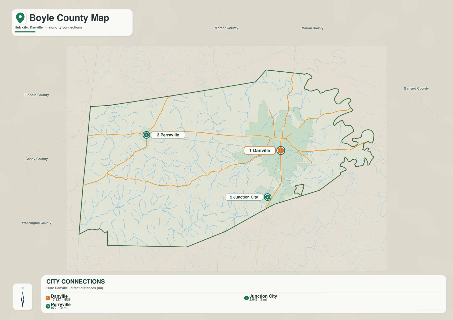
The city-connections panel places Danville well ahead of Junction City and Perryville
The supplied city panel lists Danville at an index value of 17,327, Junction City at 2,643, and Perryville at 970. These numbers are map index values rather than current official population estimates. The panel also labels Junction City at roughly 3 miles and Perryville at roughly 10 miles in straight-line distance from Danville; those are not driving distances.
Junction City belongs to the close Danville–US 127 corridor, while Perryville stands apart in the western countryside. Their different settings are easy to see when the city and terrain views are compared: Junction City lies closer to the county’s central low routes, while Perryville sits among rolling western hills cut by the Chaplin River system.
Perryville’s small index value understates its historical importance. Kentucky State Parks identifies the community as the site of the October 8, 1862 Battle of Perryville, the most destructive Civil War battle fought in Kentucky. The preserved battlefield remains one of the county’s most significant landscapes.
Chaplin River and Salt River organize the western and central drainage network
Chaplin River is the strongest water feature across western Boyle County, passing through the Perryville side and collecting smaller branches and forks from the surrounding hills. Salt River provides another long central drainage reference, with Quirks Run joining from the south. These waterways create the low corridors between otherwise rolling uplands.
Mock’s Branch and Spears Creek appear in the north, while Clark Run and Balls Branch cross the Danville side. Scrubgrass Branch and North Rolling Fork cut through the higher southwest, where narrow valleys become much more pronounced. Boyle Branch and Doctor Fork add smaller western tributary references near the Chaplin River system.
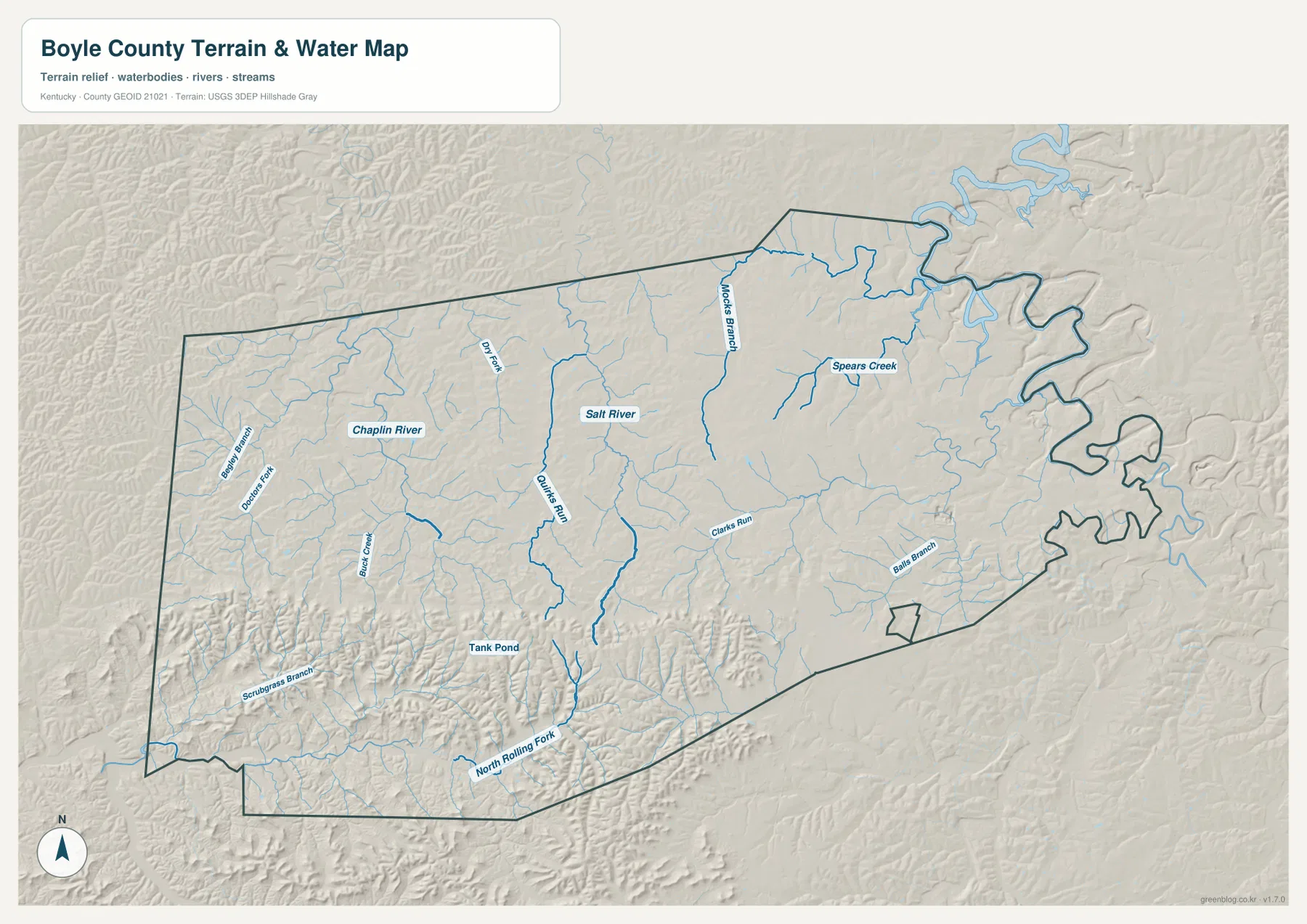
The map does not show a large reservoir dominating the county. Tank Pond appears as a small waterbody, but the county’s terrain is shaped much more strongly by rivers, runs, branches, and narrow creek valleys than by large lakes.
This image is intended for geographic reference rather than floodplain, navigation, water-quality, parcel, or legal-boundary decisions. Current agency information should be used whenever river stage, access, safety, or property decisions depend on water conditions.
Elevation from 202 to 415 meters separates Danville’s gentler terrain from the southwestern Knobs
The elevation surface ranges from about 202 to 415 meters, with a mean near 295 meters. Danville and much of the northeastern county appear in lower green and yellow-green tones, while the southwest contains long brown ridges and much stronger local relief. More than 200 meters of county-wide elevation difference creates a clear contrast between the urban center and the Knobs.
The high southwestern terrain is associated with the Forkland area and the Knobs region. Visit Danville describes Forkland as part of southwestern Boyle County’s Knobs landscape, and the elevation image shows why: North Rolling Fork and Scrubgrass Branch occupy narrow valleys between high, closely spaced ridges.
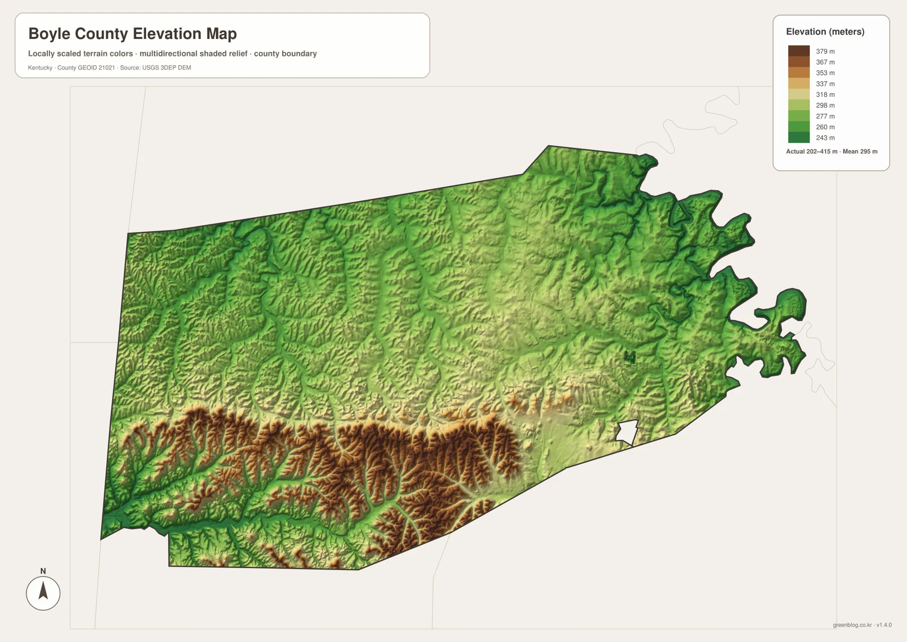
Perryville’s western hills are rolling rather than as high as the southwest ridges, and the Salt River–Quirks Run corridor creates another lower route through the center. Danville and Junction City occupy comparatively gentler terrain, helping explain why the largest settlements and main highways concentrate there.
The elevation surface is generalized for county-scale comparison. It is not survey-grade or engineering-grade measurement and should not be used for parcel elevations, construction grades, drainage design, or legal boundary work.
Constitution Square connects downtown Danville with Kentucky statehood history
The Danville-Boyle County Convention and Visitors Bureau identifies Constitution Square as the place associated with Kentucky’s emergence as a state. A series of constitutional conventions took place in Danville before Kentucky entered the Union as the fifteenth state in 1792, and the historic site preserves buildings and interpretive features tied to that period.
That history adds another layer to Danville’s central position on the map. The city is not simply the largest road junction in Boyle County; it has long served as an administrative and civic center for the surrounding region.
Centre College has kept Danville an educational center since the early nineteenth century
Centre College’s official history states that the institution was chartered in 1819 and began instruction in Old Centre in 1820. The campus remains in Danville, close to the city’s historic core, adding a major educational institution to the same community that houses the courthouse and Constitution Square.
This concentration of government, education, and historic sites helps explain why Danville has a much stronger urban footprint than the rest of Boyle County. Outside the city, roads quickly transition into farm country and creek-cut hills.
Perryville Battlefield preserves both Civil War history and the western rolling landscape
Kentucky State Parks describes Perryville Battlefield as the site of the October 8, 1862 battle that became the most destructive Civil War engagement in Kentucky. More than 7,600 soldiers were killed, wounded, or missing, and the preserved landscape now includes a museum, interpretive trails, grasslands, woodland, and wildlife habitat.
The battlefield’s location west of Danville also makes it useful for understanding the county’s terrain. Perryville sits among rolling hills and creek bottoms rather than the higher southwestern Knobs, so the site connects historical interpretation with the landforms visible on the water and elevation maps.
The Junction City side also connects with Kentucky’s first governor
Isaac Shelby Cemetery State Historic Site lies south of Danville near the Junction City area along KY 300. Kentucky State Parks identifies the half-acre cemetery as the burial place of Isaac Shelby, Kentucky’s first and fifth governor, along with members of his family.
Because Junction City is only about 3 straight-line miles from Danville on the supplied city panel, the southern corridor reads as an extension of the county’s main urban area before the landscape rises toward the southwestern Knobs. The historic site adds another county-specific reference to that transition zone.
Travel west or southwest from Danville and the landscape changes quickly
Westbound travel on KY 150 leaves Danville for Perryville through increasingly rural country shaped by Chaplin River tributaries and low ridges. The Perryville Battlefield occupies this western landscape, where open ground and rolling hills contrast with the denser Danville street network.
Southwest beyond Junction City, elevation rises more dramatically toward Forkland and the Knobs. North and east of Danville, the terrain is generally gentler and roads are more closely spaced. Boyle County therefore combines a compact central city, a historic western town, and a much more rugged southwestern landscape within a relatively short distance.
For posters, classroom prints, or presentation slides, use the original JPG files in the download archive rather than enlarging the web previews. Small route labels, creek names, city-index text, and the elevation legend remain clearer at the higher resolution.
Frequently Asked Questions
Are Danville 17,327, Junction City 2,643, and Perryville 970 current populations?
No. They are map index values supplied with this package rather than current official population estimates. The roughly 3-mile and 10-mile labels are straight-line map distances from Danville, not driving distances.
Why is southwestern Boyle County much higher than the Danville area?
The southwest enters the Knobs region, where narrow streams cut deeply between higher ridges. Danville and the northeastern county occupy gentler terrain, so the 202–415 meter elevation image shows a strong contrast between the two areas.
Why is Perryville important even though it is a small city on the map?
Perryville is the site of Kentucky’s most destructive Civil War battle, fought on October 8, 1862. The preserved battlefield extends across the rolling western landscape, making the town an important historical and geographic reference for the county.
Map File Information
The archive contains the Boyle County, Kentucky general county map, city-connections map, terrain-and-water map, and elevation map as original high-resolution JPG files.
- Included Files: Use only the versions confirmed in the article and supplied images
- File Type: Use the confirmed download contents
- Intended Use: Printing, education, presentations, and map-based projects
Related Maps
Sources and references
- Danville-Boyle County Convention & Visitors Bureau — Constitution Square, Danville, and Boyle County history
- Kentucky State Parks: Perryville Battlefield State Historic Site — battle history and preserved landscape
- Centre College: Our History — the college’s 1819 charter and Danville educational history
- Kentucky State Parks: Isaac Shelby Cemetery State Historic Site — the historic site near Junction City
- USGS National Hydrography — river and stream reference data
- USGS 3D Elevation Program — elevation and terrain reference data
Green Map creates custom-edited map images using open geographic data sources such as geoBoundaries, Natural Earth, OpenStreetMap, and government open data. These maps are edited visual materials, not raw data files, and are provided for education, documents, presentations, and graphic reference.